|
KV 27 (Unknown)
General Site Information
Structure: KV 27
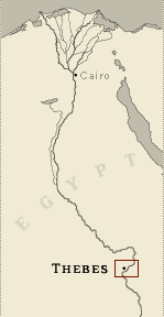
Location: Valley of the Kings, East Valley, Thebes West Bank, Thebes
Owner: Unknown
Other designations:
Site type: Tomb
Description
This undecorated tomb of unknown,
non-royal ownership is located on the east side of the same hill in
which KV 5 and KV 6 are cut, near the head of the southeast branch
off the main wadi. KV 28 lies only a few meters to the northeast and
KV 21 to the southwest. Belzoni and Wilkinson may have known of the
tomb, although it was not shown on their maps. Lefébure described it
briefly, but no documented clearance took place until Ryan cleared
debris resulting from at least seven flood events.
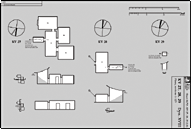
The rectangular entryway shaft A opens directly into a rectangular
chamber (B) with an axis perpendicular to the shaft. Three side
chambers open off this chamber with one on the south (Ba) and two on
the west (Bb, Bc).
Noteworthy features: The unusual design of the tomb with its
multiple side chambers is similar to KV 5 (but on a smaller scale),
and also to KV 12 and KV 30.
Site History
The lack of decoration or texts, as well as the absence of securely
datable artifacts, make dating of the tomb difficult. Its location
in a branch wadi near KV 20 and KV 43 may indicate association with
either of these tombs. Clearance in side chamber Bc yielded ceramic
remains datable to the reigns of Thutmes IV or Amenhetep III.
Dating
This site was used during the following period(s):
New Kingdom, Dynasty 18 (dated by
proximity to KV 20 and KV 43, as well as by architectural
typology)
History of
Exploration
Wilkinson, John Gardner (1825-1828): Mapping/planning
Ryan, Donald P. (1990): Excavation
Conservation
- Conservation history: Rubble walls plastered with
cement were recently constructed around the entry shaft to divert
flood water.
- Site condition: The tomb has been partially cleared
by Donald Ryan of Pacific Lutheran University. The tomb has suffered
from flood damage and until recently was used as a shelter..
|
Printable Tomb Drawings
Axis in degrees: 262.4
Axis orientation: West
Site Location
Latitude: 25.44 N
Longitude: 32.36 E
Elevation: 178.765 msl
North: 99,605.516
East: 94,245.470
JOG map reference: NG 36-10
Modern governorate: Qena (Qina)
Ancient nome: 4th Upper Egypt
Measurements
Maximum height: 2.89 m
Minimum width: 0.89 m
Maximum width: 7.65 m
Total length: 20.78 m
Total area: 91.87 m²
Total volume: 178.5 m³
Additional Tomb Information
Entrance location: Hillside
Owner type: Unknown, probably non-royal
Entrance type: Shaft
Interior layout: Chambers
Axis type: Bent
Categories of Objects Recovered
Human mummies
Vessels
|