|
Chapter 51 -
The Hammer and the Pendulum
Although beyond the scope of this book, a detailed exposition of the
earth-crust displacement theory is to be found in Rand and Rose Flem-Ath’s
When the Sky Fell (published by Stoddart, Canada, 1995).
As noted, this geological theory was formulated by Professor Charles Hapgood and supported by
Albert Einstein. In brief, what it suggests
is a complete slippage of our planet’s thirty-mile-thick lithosphere
over its nearly 8000-mile-thick central core, forcing large parts of
the western hemisphere southward towards the equator and thence
towards the Antarctic Circle. This movement is not seen as taking
place along a due north-south meridian but on a swivelling
course—pivoting, as it were, around the central plains of what is
now the United States.
The result is that the north-eastern segment
of North America (in which the North Pole was formerly located in
Hudson’s Bay) is dragged southwards out of the Arctic Circle and
into more temperate latitudes while at the same time the
north-western segment (Alaska and the Yukon) swivels northwards into
the Arctic Circle along with large parts of northern Siberia.
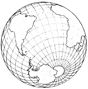
In the southern hemisphere, Hapgood’s model shows the landmass that
we now call Antarctica, much of which was previously at temperate or
even warm latitudes, being shifted in its entirety inside the
Antarctic Circle. The overall movement is seen as having been in the
region of 30 degrees (approximately 2000 miles) and as having been
concentrated, in the main, between the years 14,500 BC and 12,500
BC—but with massive aftershocks on a planetary scale continuing at
widely-separated intervals down to about 9500 BC.
According to the earth-crust displacement theory, large parts of
Antarctica were positioned outside the Antarctic circle prior to
15,000 BC and thus could have been inhabited, with a climate and
resources suitable for the development of civilization. A
cataclysmic slippage of the crust then shifted the continent to the
position it occupies today—dead centre within the Antarctic circle.
Suppose that, before the displacement of the earth’s crust, a great
civilization had grown up in Antarctica, when much of it was located
at green and pleasant latitudes? If so, that civilization might
easily have been destroyed by the effects of the displacement: the
tidal waves, the hurricane-force winds and electric storms, the
volcanic eruptions as seismic faults split open all around the
planet, the darkened skies, and the remorselessly expanding ice-cap.
Moreover, as the millennia passed, the ruins left behind—the cities,
the monuments, the great libraries, and the engineering works of the
destroyed civilization—would have been ever more deeply buried
beneath the mantle of ice.
Little wonder, if the earth-crust displacement theory is correct,
that all that can be found today, scattered around the world, are
the tantalizing fingerprints of the gods.
These would be the traces,
the echoes of the works and deeds, the much misunderstood teachings
and the geometrical edifices left behind by the few survivors of
Antarctica’s former civilization who had made it across the
turbulent oceans in great ships and settled themselves in faraway
lands: in the Nile Valley, for example (or perhaps, first, around
Lake Tana at the headwaters of the Blue Nile), and in the Valley of
Mexico, and near Lake Titicaca in the Andes—and no doubt in several
other places as well ...
Here and there around the globe, in other words, the fingerprints of
a lost civilization remain faintly visible. The body is out of
sight, buried under two miles of Antarctic ice and almost as
inaccessible to archaeologists as if it were located on the dark
side of the moon.
Fact?
Or fiction?
Possibility?
Or impossibility?
Is it a geophysical possibility or a geophysical impossibility that
Antarctica, the world’s fifth-largest continent (with a surface area
of almost six million square miles) could (a) previously have been
located in a more temperate zone and (b) have been shifted out of
that zone and into the Antarctic Circle within the last 20,000
years?
Is Antarctica movable?
A lifeless polar desert
‘Continental drift’ and/or ‘plate-tectonics’ are key terms used to
describe an important geological theory that has become increasingly
well understood by the general public since the 1950s. It is
unnecessary to go into the basic mechanisms here. But most of us are
aware that the continents in some way ‘float around’, relocate and
change position on the earth’s surface.
Common sense confirms this:
if you take a look at a map of the west coast of Africa and the east
coast of South America it’s pretty obvious that these two landmasses
were once joined. The time-scale according to which continental
drift operates is, however, immense: continents can typically be
expected to float apart (or together) at a rate of no more than 2000
miles every 200 million years or so: in other words, very, very
slowly.1
1 Encyclopaedia Britannica, 1991, 3:584.
Plate-tectonics and Charles Hapgood’s earth-crust displacement
theory are by no means mutually contradictory. Hapgood envisaged
that both could occur: that the earth’s crust did indeed exhibit
continental drift as the geologists claimed—almost imperceptibly,
over hundreds of millions of years—but that it also occasionally
experienced very rapid one-piece displacements which had no effect
on the relationships between individual landmasses but which thrust
entire continents (or parts of them) into and out of the planet’s
two fixed polar zones (the perennially cold and icy regions
surrounding the North and South Poles of the axis of
spin).
Continental drift?
Earth-crust displacement?
Both?
Some other cause?
I honestly don’t know. Nevertheless, the simple facts about
Antarctica are really strange and difficult to explain without
invoking some notion of sudden, catastrophic and geologically recent
change.
Before reviewing a few of these facts, let us remind ourselves that
we are referring to a landmass today oriented by the curvature of
the earth so that the sun never rises on it during the six winter
months and never sets during the six summer months (but rather, as
viewed from the Pole, remains low above the horizon, appearing to
transcribe a circular path around the sky during each twenty-four
hours of daylight).
Antarctica is also by far the world’s coldest continent, where
temperatures on the polar plain can fall as low as minus 89.2
degrees centigrade. Although the coastal areas are slightly warmer
(minus 60 degrees centigrade) and shelter huge numbers of seabird
rookeries, there are no native land mammals and there is only a
small community of cold-tolerant plants capable of surviving lengthy
winter periods of total or near-total darkness.
The Encyclopaedia
Britannica lists these plants laconically:
‘Lichens, mosses and
liverworts, moulds, yeasts, other fungi, algae and bacteria ...’2
2 Encyclopaedia Britannica, 1991, 1:440.
In other words, although magnificent to behold in the long-drawn-out
antipodean dawn, Antarctica is a freezing, unforgiving, almost
lifeless polar desert, as it has been throughout mankind’s entire
5000-year ‘historical’ period.
Was it always so?
Exhibit 1
Discover The World Of Science Magazine, February 1993, page 17:
‘Some 260 million years ago, during the Permian period, deciduous
trees adapted to a warm climate grew in Antarctica. This is the
conclusion palaeobotanists are drawing from a stand of fossilized
tree stumps discovered at an altitude of 7000 feet on Mount Achernar
in the Transantarctic mountains. The site is at 84° 22’ south, some
500 miles north of the South Pole.
‘ “The interesting thing about this find is that it’s really the
only forest, living or fossil, that’s been found at 80 or 85 degrees
latitude,” says Ohio State University palaeobotanist Edith Taylor,
who has studied the fossil trees.
“The first thing we palaeobotanists do is look for something in the modern records that
is comparable, and there are no forests growing at
that latitude today. We can go to the tropics and find trees growing
in a warm environment, but we can’t find trees growing in a warm
environment with the light regime these trees had: 24 hours of light
in the summer and 24 hours of dark in the winter.” ’3
3
Discover The World Of Science, February 1993, p. 17.
The fifteen
mineralized tree stumps, presumably the remnant of a much larger
forest, range from three and a half to seven inches in diameter.
They were saplings of a well-known genus of seed fern, Glossopteris
[found in much of the southern hemisphere’s coal]. Unlike true
ferns, seed ferns had seeds instead of spores, were often treelike,
and are now extinct ... All around the Mount Achernar tree stumps,
Taylor’s colleagues found the tongue-shaped imprints of fallen
Glossopteris leaves.
Deciduous trees are an indicator of a warm climate, and so is the
absence of ‘frost rings’. When Taylor analysed the growth rings in
samples from the stumps she found none of the ice-swollen cells and
gaps between cells that arise when the growth of a tree is disrupted
by frost. That means there wasn’t any frost in the Antarctic at that
time.
‘In our memory Antarctica has always been cold,’ says Taylor. ‘It’s
only by looking at fossil floras that we can see what potential
there is for plant communities. This fossil forest, growing at 85
degrees latitude, gives us some idea of what is possible with
catastrophic climate change.’
N.B. The trees were killed by a flood
or mudflow—another impossibility in Antarctica today.
4 The Path of
the Pole, p. 61. 5 Ibid., pp. 62-3.
Exhibit 2
Geologists have found no evidence of any glaciation having been
present anywhere on the Antarctic continent prior to the Eocene
(about 60 million years ago.)4 And if we go as far back as the
Cambrian (c. 550 million years ago) we find irrefutable evidence of
a warm sea stretching nearly or right across Antarctica, in the form
of thick limestones rich in reef-building Archaeocyathidae:
‘Millions of years later, when these marine formations had appeared
above the sea, warm climates brought forth a luxuriant vegetation in
Antarctica.
Thus Sir Ernest Shackleton found coal beds within 200
miles of the South Pole, and later, during
the Byrd expedition of
1935, geologists made a rich discovery of fossils on the lofty sides
of Mount Weaver, in latitude 86° 58’ S., about the same distance
from the Pole and about two miles above sea level.
These included
leaf and stem impressions and fossilized wood. In 1952 Dr Lyman H.
Dougherty, of the Carnegie Institution of Washington, completing a
study of these fossils, identified two species of a tree fern called
Glossopteris, once common to the other southern continents (Africa,
South America, Australia) and a giant fern tree of another species
...’5
Exhibit 3
Admiral Byrd’s own comment on the significance of the Mount Weaver
finds:
‘Here at the southernmost known mountain in the world,
scarcely two hundred miles from the South Pole, was found conclusive
evidence that the climate of Antarctica was once temperate or even
sub-tropical.’6
Exhibit 4
‘Soviet scientists have reported finding evidence of tropical flora
in Graham Land, another part of Antarctica, dating from the early
Tertiary Period (perhaps the Paleocene or Eocene) ... Further
evidence is provided by the discovery by British geologists of great
fossil forests in Antarctica, of the same type that grew on the
Pacific coast of the United States 20 million years ago. This of
course shows that after the earliest known Antarctic glaciation in
the Eocene [60 million years ago] the continent did not remain
glacial but had later episodes of warm climate.’7
Exhibit 5
‘On 25 December 1990 geologists Barrie McKelvey and David Harwood
were working 1830 metres above sea level and 400 kilometres [250
miles] from the South Pole in Antarctica. The geologists discovered
fossils from a deciduous southern beach forest dating from between
two and three million years ago’.8
Exhibit 6
In 1986 the discovery of fossilized wood and plants showed that
parts of Antarctica may have been ice free as little as two and a
half a million years ago. Further discoveries showed that some
places on the continent were ice-free 100,000 years ago.9
6
In Dolph Earl Hooker, Those Astounding Ice Ages, Exposition Press,
New York, 1958, page 44, citing National Geographic Magazine,
October 1935.
7 Path of the Pole, p. 62.
8 Rand Flem-Ath, Does the
Earth’s Crust Shift? (MS.).
9
Daniel Grotta, ‘Antarctica: Whose Continent Is It Anyway?’, Popular
Science, January 1992, p. 64.
Exhibit 7
As we saw in Part I, sedimentary cores collected from the bottom of
the
Ross Sea by one of the Byrd Antarctic Expeditions provide conclusive
evidence that ‘great rivers, carrying down fine well grained
sediments’ did flow in this part of Antarctica until perhaps as late
as 4000 BC. According to the report of Dr Jack Hough of the
University of Illinois:
‘The log of core N-5 shows glacial marine
sediment from the present to 6000 years ago.
From 6000 to 15,000
years ago the sediment is fine-grained with the exception of one
granule at about 12,000 years ago. This suggests an absence of ice
from the area during that period, except perhaps for a stray iceberg
12,000 years ago.’10
Exhibit 8
The Orontaeus Finnaeus World Map reviewed in Part I accurately
depicts the Ross Sea as it would look if it were free of ice and, in
addition, shows Antarctica’s ranges of lofty coastal mountains with
great rivers flowing from them where only mile-deep glaciers are to
be found today.11
Charles Hapgood, The Path Of The Pole, 1970, page 111ff:
‘It is rare
that geological investigations receive important confirmation from
archaeology; yet in this case, it seems that the matter of the deglaciation of the Ross Sea can be confirmed by an old map that has
somehow survived many thousands of years ... It was discovered and
published in 1531 by the French geographer Oronce Fine [Oronteus
Finnaeus] and is part of his Map of the World ...
It has been possible to establish the authenticity of this map. In
several years of research the projection of this ancient map was
worked out. It was found to have been drawn on a sophisticated map
projection, with the use of spherical trigonometry, and to be so
scientific that over 50 locations on the Antarctic continent have
been found to be located on it with an accuracy that was not
attained by modern cartographic science until the 19th century.
And,
of course, when this map was first published, in 1531, nothing at
all was known of Antarctica. The continent was not discovered in
modern times until about 1818 and was not fully mapped until after
1920 ...’12
10 Path of the Pole, p. 107.
11 See Part I.
12 Path of the Pole, p. 111ff.
13 See Part I for details.
Exhibit 9
The Buache Map, also reviewed in Part I, accurately depicts the subglacial topography of Antarctica.13 Does it do so by chance or
might the continent indeed have been entirely ice-free recently
enough for the
cartographers of a lost civilization to have mapped it?
Exhibit 10
The reverse side of the coin. If the lands presently inside the
Antarctic Circle were once temperate or tropical, what about lands
inside the Arctic Circle? Were they affected by the same dramatic
climate changes, suggesting that some common factor might have been
at work?
‘On the island of Spitzbergen (Svalbard), palm leaves ten and twelve
feet long have been fossilized, along with fossilized marine
crustaceans of a type that could only inhabit tropical waters. This
suggests that at one time the temperatures of the Arctic Ocean were
similar to the contemporary temperatures of the Bay of Bengal or the
Caribbean Sea.
Spitzbergen is half way between the northern tip of
Norway and the North Pole, at a latitude of 80 degrees N. Today,
ships can reach Spitzbergen through the ice only about two or at the
most three months during the year.’14
There is firm fossil evidence that stands of swamp cypress
flourished within 500 miles of the North Pole in the Miocene
[between 20 million and 6 million years ago], and that water-lillies
flourished in Spitzbergen in the same period:
‘The Miocene floras of
Grinnell Land and Greenland, and Spitzbergen, all required temperate
climatic conditions with plentiful moisture.
The water lillies of
Spitzbergen would have required flowing water for the greater part
of the year. In connection with the flora of Spitzbergen it should
be realized that the island is in polar darkness for half the year.
It lies on the Arctic Circle, as far north of Labrador as Labrador
is north of Bermuda.15
Some of the islands in the Arctic Ocean were never covered by ice
during the last Ice Age. On Baffin Island, for example, 900 miles
from the North Pole, alder and birch remains found in peat suggest a
much warmer climate than today less than 30,000 years ago. These
conditions prevailed until 17,000 years ago:
‘During the Wisconsin
ice age there was a temperate-climate refuge in the middle of the
Arctic Ocean for the flora and fauna that could not exist in Canada
and the United States.’16
14 The Biblical Flood and the Ice Epoch, pp. 109-10.
15 Path of the
Pole, p. 66.
16 Ibid., pp. 93, 96.
Russian scientists have concluded that the Arctic Ocean was warm
during most of the last Ice Age. A report by academicians Saks,
Belov and Lapina covering many phases of their oceanographic work
highlights the period from about 32,000 to about 18,000 years ago as
being one during which particularly warm conditions prevailed.17
As we saw in Part IV, huge numbers of warm-blooded, temperate
adapted mammal species were instantly frozen, and their bodies
preserved in the permafrost, all across a vast zone of death
stretching from the Yukon, through Alaska and deep into northern
Siberia. The bulk of this destruction appears to have taken place
during the eleventh millennium BC, although there was an earlier
episode of large-scale extinctions around 13,500 BC.18
We also saw (Chapter Twenty-seven) that the last Ice Age came to an
end between 15,000 and 8000 BC, but principally between 14500 and
12,500 BC, with a further outburst of extraordinarily intense
activity in the eleventh millennium BC. During this geologically
brief period of time, glaciation up to two miles deep covering
millions of square miles which had taken more than 40,000 years to
build-up suddenly and inexplicably melted:
‘It must be obvious that
this could not have been the result of the gradually acting climatic
factors usually called upon to explain ice ages ... The rapidity of
the deglaciation suggests that some extraordinary factor was
affecting climate ...’19
17 Ibid., p. 99.
18 See Part IV.
19 Ibid.
The icy executioner
Some extraordinary factor was affecting climate ...
Was it a 30° one-piece shift of the lithosphere that abruptly
terminated the Ice Age in the northern hemisphere (by pushing the
most heavily glaciated areas southwards from the northern pole of
the spin axis)? If so, why shouldn’t the same 30° one-piece shift of
the lithosphere have swivelled a largely deglaciated
six-million-square-mile southern hemisphere continent from temperate
latitudes to a position directly over the southern pole of the spin
axis?
On the issue of the movability of Antarctica, we now know that it is
movable and, more to the point, that it has moved, because trees
have grown there and trees simply cannot grow at latitudes which
suffer six months of continual darkness.
What we do not know (and may never know for certain) is whether this
movement was a consequence of earth-crust displacement, or of
continental drift, or of some other unguessed-at factor.
Let us consider Antarctica for a moment.
We have already seen that it is big. It has a land area of 5.5
million
square miles, and is presently covered by something in excess of
seven million cubic miles of ice weighing an estimated 19
quadrillion tons (19 followed by 15 zeros).20 What worries the
theorists of earth-crust displacement is that this vast ice-cap is
remorselessly increasing in size and weight: ‘at the rate of 293
cubic miles of ice each year—almost as much as if Lake Ontario were
frozen solid annually and added to it.’21
The fear is that when it is coupled with the effects of precession,
obliquity, orbital eccentricity, the earth’s own centrifugal motion,
and the gravitational tug of the sun, moon and planets, Antarctica’s
huge, ever-expanding burden of glaciation could provide the final
trigger-factor for a massive displacement of the crust:
The growing South Pole ice-cap [wrote
Hugh Auchincloss Brown,
somewhat colourfully, in 1967] has become a stealthy, silent and
relentless force of nature— a result of the energy created by its
eccentric rotation. The ice-cap is the creeping peril, the deadly
menace and the executioner of our civilization.22
Did this ‘executioner’ cause the end of the last Ice Age in the
northern hemisphere by setting in motion a 7000-year shift of the
crust between 15,000 BC and 8000 BC—a shift that was perhaps at its
most rapid, and would have had its most devastating effects, between
14,500 BC and 10,000 BC?23
Or were the sudden and dramatic climate
changes experienced in the northern hemisphere during this period
the result of some other catastrophic agency simultaneously capable
of melting millions of cubic miles of ice and of sparking off the
worldwide increase in volcanism that accompanied the melt-down?24
Modern geologists are opposed to catastrophes, or rather to
catastrophism, preferring to follow the ‘uniformitarian’ doctrine:
‘that existing processes, acting as at present, are sufficient to
account for all geological changes’. Catastrophism, on the other
hand, holds that,
‘changes in the earth’s crust have generally been
effected suddenly by physical forces.’25
Is it possible, however,
that the mechanism responsible for the traumatic earth changes which
took place at the end of the last Ice Age could have been a
geological event both catastrophic and uniform?
20
Encyclopaedia Britannica, 1991, 1:440; John White, Pole Shift,
A.R.E. Press, Virginia Beach, 1994, p. 65.
21 Pole Shift, p. 77:
Twenty billion tons of ice are added each year at Antarctica.
22 H.
A. Brown, Cataclysms of the Earth, pp. 10-11.
23 See Part IV.
24
Ibid.
25 Biblical Flood and the Ice Epoch, p. 228.
The great biologist Sir Thomas Huxley remarked in the nineteenth
century: To my mind there appears to be no sort of theoretical
antagonism between Catastrophism and Uniformitarianism; on the
contrary, it is very conceivable that catastrophes may be part and
parcel of uniformity. Let me illustrate my case by analogy. The
working of a clock is a model of uniform action. Good timekeeping
means uniformity of action. But the striking of a clock is
essentially a catastrophe.
The hammer might be made to blow up a barrel of gunpowder, or turn
on a deluge of water and, by proper arrangement, the clock, instead
of marking the hours, might strike at all sorts of irregular
intervals, never twice alike in the force or number of its blows.
Nevertheless, all these irregular and apparently lawless
catastrophes would be the result of an absolutely uniformitarian
action, and we might have two schools of clock theorists, one
studying the hammer and the other the pendulum.26
26 Thomas Huxley cited in Path of
the Pole, p. 294.
Could continental drift be the pendulum? Could earth-crust
displacement be the hammer?
Mars and earth
Crustal displacements are thought to have taken place on other
planets. In the December 1985 issue of Scientific American, Peter H.
Schultz drew attention to meteorite impact craters visible on the
Martian surface. Craters in polar areas have a distinctive
‘signature’ because the meteorites land amid the thick deposits of
dust and ice that accumulate there.
Outside the present polar
circles of Mars, Schultz found two other such areas:
‘These zones
are antipodal; they are on opposite faces of the planet. The
deposits show many of the processes and characteristics of today’s
poles, but they lie near the present-day equator ...’
What could have caused this effect?
Judging from the evidence,
Shultz put forward the theory that the mechanism appeared to have
been,
‘the movement of the entire lithosphere, the solid outer
portion of the planet as one plate ... [This movement seems to have
taken place] in rapid spurts followed by long pauses.’27
If crustal displacements can happen on Mars, why not on earth? And
if they don’t happen on earth, how do we account for the otherwise
awkward fact that not a single one of the ice-caps built up around
the world during previous Ice Ages seems to have occurred at—or even
near—either of the present poles.28 On the contrary, land areas
bearing the marks of former glaciation are very widely distributed.
If we cannot assume crustal shifts, we must find some other way to
explain why the ice-caps appear to have reached sea level within the
tropics on three continents: Asia, Africa and Australia.29
27 Scientific
American, December 1985.
28 Path of the Pole, pp. 47-9.
29 Ibid., p.
49.
Charles Hapgood’s solution to this problem is simple, extremely
elegant and does not affront commonsense: The only ice age that is
adequately explained is the present ice age in Antarctica. This is
excellently explained. It exists, quite obviously, because
Antarctica is at the pole, and for no other reason. No variation of
the sun’s heat, no galactic dust, no volcanism, no subcrustal
currents, and no arrangements of land elevations or sea
currents account for the fact.
We may conclude that the best theory
to account for an ice age is that the area concerned was at the
pole. We thus account for the Indian and African ice sheets, though
the areas once occupied by them are now in the tropics. We account
for all ice sheets of continental size in the same way.30
30 Ibid., p. 58.
The logic is close to inescapable. Either we accept that the
Antarctic ice cap is the first continent-sized ice sheet ever to
have been situated at a pole—which seems improbable—or we are
obliged to suppose that earth-crust displacement, or a similar
mechanism, must have been at work.
Memories of the polar dawn?
Our ancestors may have preserved in their most ancient traditions
memories of a displacement. We saw some of these memories in Part
IV: cataclysm myths that appear to be eyewitness accounts of the
series of geological disasters which accompanied the end of the last
Ice-Age in the northern hemisphere.31
There are other myths too,
which may have come down to us from that epoch between 15,000 and
10,000 BC. Among these are several which speak of lands of the gods
and of former paradises, all of which are described as being in the
south (for example, the Ta-Neteru of the Egyptians) and many of
which seem to have experienced polar conditions.
The great Indian epic, Mahabaratha, speaks of Mount Meru, the land
of the gods:
At Meru the sun and moon go round from left to right
every day, and so do all the stars ... The mountain by its lusture,
so overcomes the darkness of night, that the night can hardly be
distinguished from the day. ... The day and night are together equal
to a year to the residents of the place ...32
Similarly, as the reader will recall from Chapter Twenty-five,
Airyana Vaejo, the mythical paradise and former homeland of the
Avestic Aryans of Iran, seems to have been rendered uninhabitable by
the sudden onset of glaciation. In later years it was spoken of as a
place in which:
‘the stars, the moon and the sun are only once a
year seen to rise and set, and a year seems only as a day.’33
In the Surya Siddhanta, an ancient Indian text, we read, ‘The gods
behold the sun, after it has once arisen, for half a year.’34
31 See Part IV.
32 The Mahabaratha, cited in The Arctic Home in the Vedas, pp. 64-5.
33 Ibid., pp. 66-7.
34 Cited in Paradise Found: The Cradle of the Human Race at the
North Pole, p. 199.
The
seventh Mandala of the Rigveda contains a number of ‘Dawn’ hymns.
One of these (VII, 76) says that the dawn has raised its banner on
the horizon with its usual splendour and reports in Verse 3 that a
period of several days elapsed between the first appearance of the
dawn and the rising of
the sun that followed it.35 Another passage states, ‘many were the
days
between the first beams of the dawn and actual sunrise’.36
Are these
eyewitness accounts of polar conditions? Although we can never be
sure, it may be relevant that in Indian
tradition the Vedas are believed to be revealed texts, passed down
from the time of the gods.37 It may also be relevant that in
describing the processes of transmission, all the traditions refer
to the pralayas (cataclysms) which occasionally overtake the world
and claim that in each of these the written scriptures are
physically destroyed.
After each destruction, however, certain Rishis or ‘wise men’ survive who
re-promulgate, at the beginning of the new age, the knowledge
inherited by them as a sacred trust from their forefathers in the
preceding age ... Each manvantara or age thus has a Veda of its own
which differs only in expression and not in sense from the
antediluvian Veda.38
35 Arctic Home in the Vedas, p. 81.
36 Ibid., p. 85.
37 Ibid., pp. 414, 417.
38 Ibid., p. 420.
An epoch of turmoil and darkness
As every schoolboy geographer understands, true north (the North
Pole) is not quite the same thing as magnetic north (the direction
compass needles point). Indeed the magnetic north pole is presently
situated in northern Canada, about 11 degrees from the true North
Pole.39 Recent advances in the study of palaeomagnetism have proved
that the earth’s magnetic polarity has reversed itself more than 170
times during the past 80 million years ...40
What causes these field reversals?
While he was teaching at the University of Cambridge the geologist
S. K. Runcorn published an article in Scientific American which made
a pertinent point:
There seems no doubt that the earth’s magnetic field is tied up in
some way to the rotation of the planet. And this leads to a
remarkable finding about the earth’s rotation itself ... [The
unavoidable conclusion is that] the earth’s axis of rotation has
changed also. In other words, the planet has rolled about, changing
the location of the geographical poles.41
39 Pole Shift, p. 9.
40 Ibid.
41 Ibid., p. 61.
Runcorn appears to be envisaging a complete 180-degree flip of the
poles, with the earth literally tumbling—although similar
palaeomagnetic readings would result from a slippage of the crust
over the geographical poles. Either way, the consequences for
civilization, and indeed for all life, would be unimaginably
dreadful.
Of course, Runcorn may be wrong; perhaps field reversals can occur
in the absence of any other upheavals.
But he may also be right.
According to reports published in Nature and New Scientist, the last
geomagnetic reversal was completed just 12,400 years ago—during the
eleventh millennium BC.42
This is of course the very millennium in which the ancient Tiahuanacan civilization in the Andes seems to have been destroyed.
The same millennium is signalled by the alignments and design of the
great astronomical monuments on the Giza plateau, and by the erosion
patterns on the Sphinx.
And it was in the eleventh millennium BC
that Egypt’s ‘precocious agricultural experiment’ suddenly failed.
Likewise it was in the eleventh millennium BC that huge numbers of
large mammal species all around the world vanished into extinction.
The list could continue: abrupt rises in sea level, hurricane-force
winds, electrical storms, volcanic disturbances, and so on.
Scientists expect the next reversal of the earth’s magnetic poles to
occur around AD 2030.43
Is this an intimation of planetary disaster? After 12,500 years of
the pendulum, is the hammer about to strike?
Exhibit 11
Yves Rocard, Professor of the Faculty of Sciences at Paris:
‘Our
modern seismographs are sensitive to the ‘noise’ of limited
agitation at every point in the earth, even in the absence of any
seismic wave. One may in this noise discern a man-made vibration
(for example, a train four kilometers away, or a big city ten
kilometers off) and also an atmospheric effect (from changing
pressure of the wind on the soil) and sometimes one registers also
the effects of great storms at a distance. Yet there remains a
continued rolling noise of cracklings in the earth which owes
nothing to any [such] cause ...’44
42
Nature, volume 234, 27 December 1971, pp. 173-4; New Scientist, 6
January 1972, p.
7.
43 J. M. Harwood and S. C. R. Malin writing in Nature, 12 February
1976.
44 The Path of the Pole, op. cit., Appendix, pp. 325-6.
Exhibit 12
‘The North Pole moved ten feet in the direction of Greenland along
the meridian of 45 degrees west longitude during the period from
1900 to 1960 ... a rate of six centimeters (about two and a half
inches) a year. [Between 1900 and 1968, however,] the pole moved
about twenty feet. [The pole therefore] moved ten feet between 1960
and 1968, at a rate of
about ten centimeters (four inches) a year ...
If both these
observations were accurate when made, as we have every right to
expect in view of the eminence of the scientists involved, then we
have here evidence that the lithosphere may be in motion at the
present time [and that it is experiencing] a geometrical
acceleration of the rate of motion ...45
Exhibit 13
USA Today, Wednesday 23 November 1994, page 9D:
‘INTERACTIVE IN ANTARCTICA: Students Link With South Pole
Scientists
‘A live remote broadcast from the South Pole featuring
Elizabeth
Felton, a 17-year-old graduate of Chicago public schools, will take
place Jan 10. Felton will use US Geological Survey data to
reposition the copper marker designating the Earth’s geographic
South Pole to compensate for the annual slippage of the ice
sheet.’46
45 Ibid., p. 44.
46 USA Today, 23 November 1994, p. 9D.
Is it just the ice sheet that is slipping, or is the entire crust of
the earth in motion? And was it just an ‘unusual interactive
education project’ that took place on 10 January 1995, or was
Elizabeth Felton unknowingly documenting the continued geometrical
acceleration of the rate of motion of the crust?
Scientists do not think so. As we shall see in the final chapter,
however, the coming century is signalled in a remarkable convergence
of ancient prophecies and traditional beliefs as an epoch of
unprecedented turmoil and darkness, in which iniquity will be worked
in secret, and the Fifth Sun and the Fourth World will come to an
end ...
Exhibit 14
Kobe, Japan, Tuesday 17 January 1995:
‘The suddenness with which the
earthquake struck was almost cruel. One moment we were fast asleep,
an instant later the floor—the entire building—had turned to jelly.
But this is no gently undulating liquid motion. This is jarring,
gut-wrenching shuddering of awesome proportions ...
‘You are in bed, the safest place in the world. Your bed is on the
floor, what you used to think of as solid ground. And with no
warning the world has turned into a sickening roller-coaster ride,
and you want to get off.
‘Possibly the most frightening part is the sound. This is not the
dull rumble of thunder. This is a deafening, roaring sound, coming
from everywhere and nowhere, and it sounds like the end of the
world.’ (Eyewitness report on the Kobe earthquake by Dennis Kessler,
Guardian,
London, 18 January 1995. The tremor lasted 20 seconds, registering
7.2 on the Richter scale, and killed more than 5000 people.)
Back to
Contents
or
Continue to Chapter 52
→
Back to
Antarctica Rediscovered
|