|
ENDOTHERMIC
MODE SLIDE 41.
In
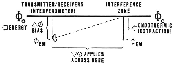
the endothermic mode, the bias on the transmitters is such that energy is
extracted from the distant intersection zone, to re-emerge at the
transmitters. There the energy must be caught and disposed of if it is not to
burn out the transmitters. When very large amounts of energy are extracted from
distant points, the Soviets often use a "dump" method of
temporarily capturing, and storing in an accumulator, the heat energy emerging
at the transmitters. A second howitzer in the exothermic mode is then fed by a
"scalar energy tap" established into the accumulator. This howitzer is
focused on a distant dump site -- often Bennett Island, where
exhausts are continually observed by U.S. weather satellites. In
the impulsive endothermic mode, energy is impulsively extracted from the distant
intersection zone. In the atmosphere this results in a very sharp cooling, or a
"cold explosion." It also results in the type of boom and rumble often
associated with thunder after a lightning bolt. On April 9, 1984 the Soviet Union tested such a "cold explosion" off the coast of Japan, near the Kuril Islands. In the suddenly induced low pressure "cold zone" above the ocean, ocean water was sharply sucked up from the ocean, forming a dense cloud. Then air rushing in to the low pressure zone forced the cloud upward, forming a mushroom much like that of an atomic explosion in visual appearance, except for the absence of a flash and the absence of a giant shock wave moving out away from the site of the explosion. (In this case the Soviets controlled the rise time of the pulse so that no "giant atmospheric boom" occurred.). As
the cloud rises, it expands by mixing -- very similar to a giant
thunderhead buildup, except much faster. In this case the cloud rose to 60,000
feet in about 2 minutes, spreading out until it reached a diameter of about 200
miles. The incident was seen by the pilots and crews of several Boeing 747 jet
airliners in the general vicinity. Sometime after that, a U.S. weather satellite
photo of the area occurred. The cloud in that photo has an anomalous density
distribution, differing from that of all other clouds in the area. |