|
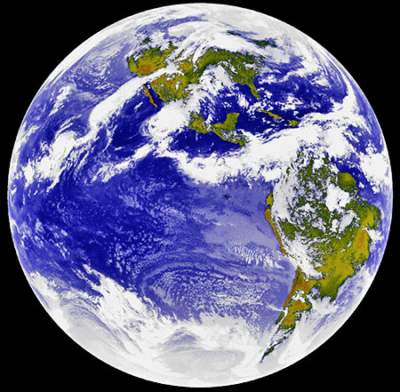
Johan has given us an update
about the conditions there. I find his descriptions of South Africa
quite interesting and thought others would enjoy them as well.
They in turn control the meteorologists with their licenses by prohibiting them from reporting any weather conditions which are not first reported by the NWS. In other words, if the local weathercaster declares a tornado, they will lose their license if the NWS did not report it first.
One of these was a Little Rock, AR
meteorologist who saved the town by setting off the tornado siren
when the NWS refused to declare a tornado. I believe this was in the
1990's.
When they returned, she
was gone and was never seen again. Nor did anyone else ever make
such a statement about the spiral storms again.
They also cut him off in mid sentence
and he was gone when they returned from commercials and never
returned. This was around Feb 2009, I think.
When business is down at the local hospitals, they run news segments on scanning machines and old technology checkups to boost business.
They only devote one sentence to any
real news item. Nothing negative which might chase away Consumer
business or tourism or pique anyone's concerns about weather changes
or global problems.
Even when we are 103 to 106 degrees, they report 97 or 98, etc. Or 10 inches of rain as 2.5. If they get caught, they claim microclimates as the reason.
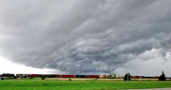
They frequently declare tornadoes to be straight-line winds even with a thousand witnesses unless you can capture and prove it was a tornado on multiple films from multiple sources.
Here is one of their straight-line Winds on a photo I took near Greenville, TX.
Does this look like straight-line winds?
Or the WTC from 50,000 dead, reduced to under 3000. They sugar coat the results to stop angry mobs from forming or to disguise their complicity in false flag attacks or corrupt government mishandling of disaster management.
As a former major metro Emergency
management agency member, this is just a drop in the bucket to the
corrupt tricks the government has already done and will do. And to
think we used to complain about Soviet propaganda. They don't begin
to compare to what our own US government has done.
For instance, the shape of the US Jet Stream which affects our climate and storm formations which never used to dip further south than the Dallas area has been dipping down into central Mexico during the warmer months since the axis shifts began in 2003 and 2004.
Prior to the axis shift the Jet Stream never dipped into Mexico.
This shift in the Jet Stream is exactly
what we would expect with an axis shift. The change in southerly dip
of the Jet Stream corresponds with the shift of the axis during the
summer months.
However, since the winter Jet Stream dip no longer comes down to Texas and no longer brings down the Canadian cold air, the southern states now experience warmer winters.
Just follow the Jet Stream...
The Canadian Inuit tribes have also noticed a difference in the sun position as well, which you can read on my old posts. So when you are reading the opinions of others, keep in mind the age group of the person providing them. Age group affects knowledge, quality of education, attitude and personal experience.
How can they relate to changes they have never seen before the shift. It also depends on how much attention they have paid to the sun position and weather conditions. It sometimes takes years of experience to notice changes. Even those at 45 now would have only been 30 in 2000.
So the best observers before
and after the axis shift would now be over 55 and aware of their
environment.
These are the spiraling gravity fields
which control the spinning of water in drains, or the spinning of
hurricanes and tornadoes. The spinning direction is reversed in the
southern hemisphere.
We had over 30 inches of rain last May
2015. Then, 10 inches this past January in less than one week. At
the time of my January post only 6 inches had rained. It was over 10
inches when it had finished.
So for May 2007, the weather animation will show you the weather cloud patterns as it steps through each day of the month at 4PM.
Keep an eye on Oklahoma for the spinning
storms I described which occurred every spring, day after day from
the last week of April thru the first week of June. But only after 2005. Not before. Another effect of the axis shift is on the temperatures of the oceans and oceanic water flow patterns.
The pacific coast used to have frigid arctic waters along the California coast. Quite a difference from our warm Atlantic coast or gulf coast. I have lived on both coasts and the gulf area as well. There is a huge temperature difference.
The icy cold Pacific coast waters before the axis began shifting in 2003 and 2004 caused rain storms to develop over California every winter when the warm air contacted the frigid coastal waters which flowed down the California coast from Alaska.
Creating weekly winter rain in
California and snow in the mountains.
Massive amounts of wasted water on unneeded rice crops while warehouses in Thailand have tons of rice rotting in storage while California's precious water resources are wasted.
Are these California rice farmers paying
for the billions of gallons of water they are wasting?
The only good thing will be the loss of
sharks from lack of favored food sources but not until sharks have
shifted to humans and dolphins as an alternate food source.
It might be interesting to watch for these spinning hurricane like storm systems over the central US between the last week of April and first week of June.
Also keep an eye on the Jet Stream behavior as well.
The equinox dates are Sept 23rd and Mar 21st. Despite the axis shift which depending on the year, has extended the tropic of cancer 850-2000 miles (depending on the year) north of its normal position in mid Mexico on June 21st the summer solstice and 850-2000 miles south of the tropic of Capricorn during the winter solstice on Dec 21st… that means the equator is still the midpoint despite the axis shift.
The amount of the shift will alter the sun position equally north in the Summer and to its opposite and equal position to the south in December.
This is due to the way we orbit
the sun at a tilt. Even with an exaggerated or increased tilt, the
sun is the same distance too far north during June as it is the same
equal distances too far south in December.
This was also the same midpoint when the axis was normal. So no matter how much the axis shifts, it will always measure the same over the equator in March and Sept. equinoxes.
During the spring and fall months the sun travels between the tropics of Capricorn and Cancer crossing the equator on the equinox dates I mentioned above. It performed this journey the same way before 2000 Y2K or now.
And still does so whether the axis tilt and tropic lines were normal or whether each tropic line had shifted 850-2000 miles beyond their normal tropic lines with the increased axis shifts and tilt.
The difference before Y2K was the shorter distance the sun traveled between the two tropic lines. After the axis shift that distance of travel increased.
For instance, when the
earth shifted 850 miles to the north, the sun traveled an extra 1700
miles between the 2 increased tropic lines but was always over the
equator on the spring and fall equinoxes.
This is because of the way earth orbits the
sun at a tilt. This was taught in 3rd grade science.
One other item concerns comparing sun position over certain spans of years.
Most of the axis shifts occurred after 2003 and before 2007. Between 2007 and 2013 only a couple small shifts occurred. For several years it remained at the same position. So if you compared the wrong years, there were no changes at all.
Then then was the huge increase between 2013 and 2014.
Then the significant reversal between 2014 and 2015,
There have been several people jumping the gun who are trying to compare the sun position this month, so it appears I need to explain why it cannot be done in spring or fall.
Only the solstice dates can provide the info we need.
These are the two days of the year when
the sun is the farthest north and farthest south, indicating when it
is directly over the tropics of Cancer and Capricorn, and how far beyond those lines it
has traveled due to the axis shift.
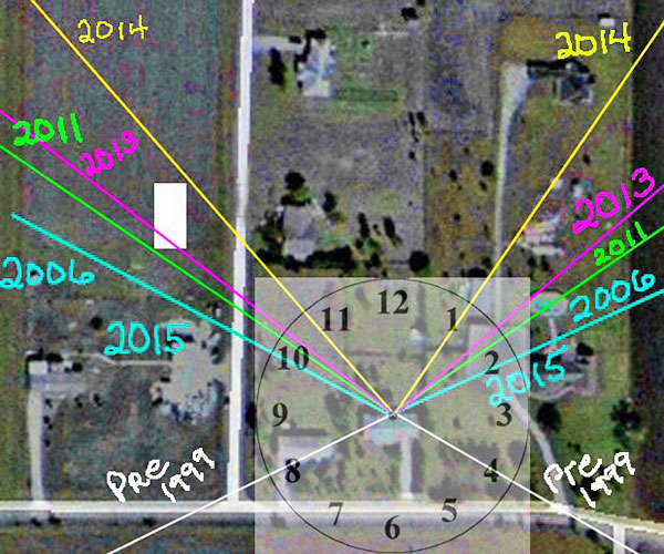
E clock face solar angle changes
April 21, 2014
from
Youtube Website
See also "Possible 'Post-Transition' Continental Maps".
|