|

from
LostCivilizations Website
Physical Evidence of Atlantis - 1
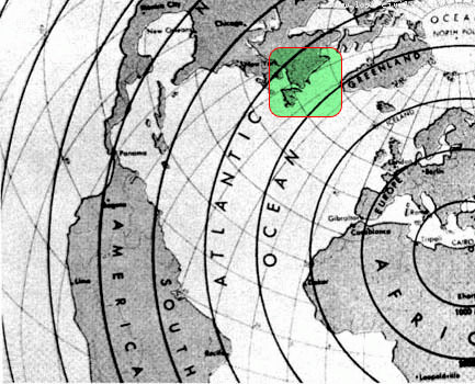
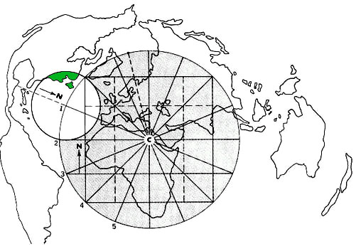
The Piri Reis Map of 1513 is the
first surviving map that shows the Americas (the Vinland map may be
older but only shows a part of North America). The Piri Reis map
shows North America, South America, Greenland and Antarctica which
had not yet been discovered. Piri Reis was a famous admiral
of the Turkish fleet in the sixteenth century. His passion was
cartography, he was always on the lookout for new maps and other
such documents. In 1513 a map had been commissioned him.
Piri Reis was high rank within the Turkish navy which allowed him to
have a privileged access to the Imperial Library of Constantinople.
He was considered an expert on Mediterranean lands and coastlines,
and he even wrote a famous sailing book called
Kitabi Bahriye
where he described all the details of coastlines, harbors, currents,
shallows, bays and straits of the Mediterranean and Aegean seas. He
died in 1554 or 1555 being beheaded for unknown reasons.
It is said that in a now-forgotten sea battle he met, among the
prisoners, a sailor who claimed to have been sailing along with
Columbus in his three journeys to the new world, and that he was one
of his pilots. It turned out that Columbus had a map of the lands he
was chasing, and that this map now was in the possession of that
pilot.
Admiral Piri Reis got to put hands and eyes on the map; then in 1513
he compiled a world map based on that map and on the other antique
charts from his collection - many of which had survived from the
days of the Great Library of Alexandria.
The map had drawn the attention of scholars in 1929 when it had been
discovered in the archives of the Imperial Palace in Constantinople.
The map showed the outline of South America very accurately. This
was surprising since Columbus had discovered the New World only 21
years earlier in 1492. Notes made by Piri indicated he had based his
map on earlier maps, including one consulted by Columbus before his
famous voyage.
This excited the scholars since there had been rumors that there
existed a pre-Columbian map of the New World. Piri's claim that he
had possessed the "lost map" intrigued historians.
It wasn't the accuracy of the South American coastline that
interested Mallery, though. It was what was shown at the very bottom
of the map: a chunk of land that looked very much like Antarctica.
This was surprising since Antarctica had not been discovered until
1820. Even more intriguing was a section of the coastline of this
southern continent. Part of it looked very much like the coast of
Queen Maud Land which was a section of Antarctica.
The strange thing was that the coast of Queen Maud Land had been
covered with a thick sheet of ice for many centuries and its shape
was only known now to modern mapmakers through the use of modern
seismographic equipment.
This made Mallory wonder if the Admiral had somehow owned maps that
dated back before the ice sheet covered the coast and if the coast
had been somehow surveyed from the air. Most serious professional
geographers, though, rejected Mallery's radical theory without even
considering it carefully.
Professor Charles H. Hapgood, of Keene State College at
the University of New Hampshire, did take an interest in the map
and Mallory's thoughts. Professor Hapgood was known for his support
of unorthodox theories. With the help of some of his students,
Hapgood did a careful examination of Piri's map and several other
old maps and published a book on the subject called Maps of the
Ancient Sea Kings.
The book suggests that at one time in the ancient past there was a
world-wide civilization with advanced technology. Though this
civilization was destroyed, some of its knowledge survived to wind
up in the maps.
Later, an even more radical theory for Piri's map was advanced from
writer Eric Von Daniken. Von Daniken, a supporter of the idea
that aliens had visited Earth in the distant past, noted that the
map resembled what might be seen from space if you took a picture of
Earth from directly over Cairo, Egypt. He suggested that the map was
the result of aerial photographs taken from an alien spaceship.
Critics of Hapgood and Von Daniken offer a more mundane explanation
for the map. They start by pointing out that lots of maps from that
era displayed a continent at the bottom of the Earth, though none
had yet been found.
There was a general belief going back to the time of the Greeks that
all the continents must have been connected at one time. This lead
to the belief in a southern continent (Interestingly enough, they
were correct. The modern theory of plate tectonics supports the idea
of single land mass in the very distant past).
The critics point out that the land mass shown on the map may have a
similar coastline to that of Queen Maud Land, but the
similarity is not unmistakable. What is on Piri's map, they argue,
is just a lucky attempt to display an unknown, but suspected land.
The similarity, say critics, is just coincidence.
They also point out that the map shows South America and Antarctica
connected, which they have not been for many millions of years. Also
information about weather conditions and animal life in Antarctica
as found on the map is completely wrong.
Other experts speculate that though the first recorded sighting of
land in the Antarctica was in 1820, there may have been earlier
unreported voyages to the southern reaches.
Though this might not explain the coastline of Queen Maud Land on
the Piri map, it might be the reason that there was such a strong
belief in the existence of a southern continent.
Maps of the
Ancient Sea Kings
An ancient map that
King Henry owned in 1500 A.D. clearly shows Atlantis
Greek documents and maps showing Atlantis that Christopher Columbus
studied before he set sail for America,
including the 1482
Benincasa Map showing 3 Atlantis islands that no longer exist!
Explorers View 'Lost City' Ruins Under
Caribbean
from
WorldHistoryArchives Website
December 6, 2001
Reuters
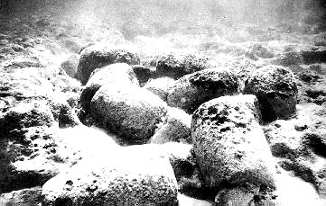
Explorers using a miniature submarine to probe the sea floor
off
the coast of Cuba said on Thursday they had confirmed the
discovery of stone structures deep below the ocean surface that
may have been built by an unknown human civilization thousands
of years ago.
Researchers with a Canadian exploration company said they filmed
over the summer ruins of a possible submerged "lost city'' off
the Guanahacabibes Peninsula on the Caribbean island's western
tip. The researchers cautioned that they did not fully
understand the nature of their find and planned to return in
January for further analysis, the expedition leader said on
Thursday.
The explorers said they believed the
mysterious structures, discovered at the astounding depth of
around 2,100 feet and laid out like an urban area, could have
been built at least 6,000 years ago. That would be about 1,500
years earlier than the great Giza pyramids of Egypt.
"It's a really wonderful
structure which looks like it could have been a large urban
center,'' said Soviet-born Canadian ocean engineer
Paulina Zelitsky, from British Columbia-based Advanced
Digital Communications (ADC).
Zelitsky said the structures may
have been built by unknown people when the current sea-floor
actually was above the surface. She said volcanic activity may
explain how the site ended up at great depths below the
Caribbean Sea.
In July 2000, ADC researchers using
sophisticated side-scan sonar equipment identified a large
underwater plateau with clear images of symmetrically organized
stone structures that looked like an urban development partly
covered by sand. From above, the shapes resembled pyramids,
roads and buildings, they said.
This past July, ADC researchers, along with the firm's Cuban
partner and experts from the Cuban Academy of Sciences, returned
to the site in their ship "Ulises.'' They said they sent a
miniature, unmanned submarine called a Remotely Operated
Vehicle (ROV) down to film parts of the
7.7-square-mile area.
Those images confirmed the presence of huge, smooth, cut
granite-like blocks in perpendicular and circular formations,
some in pyramid shapes, the researchers said. Most of the
blocks, measuring between about 6.5 and 16 feet in length, were
exposed, some stacked one on another, the researchers said.
Others were covered in sediment and the fine, white sand that
characterizes the area, the researchers said.
The intriguing discovery provided evidence that Cuba at one time
was joined to mainland Latin America via a strip of land from
the Yucatan Peninsula, the researchers said.
"There are many new hypotheses
about land movement and colonization, and what we are seeing
here should provide very interesting new information,''
Zelitsky said.
ADC's deep-water equipment includes
a satellite-integrated ocean bottom positioning system,
high-precision side-scan double-frequency sonar, and the ROV.
The company currently is commissioning what it calls the world's
first custom-designed ocean excavator for marine archeology to
begin work both at the Guanahacabibes site and at ship wrecks.
ADC is the deepest operator among four foreign firms working in
joint venture with President Fidel Castro (news - web sites)'s
government to explore Cuban waters containing hundreds of
treasure-laden ships from the colonial era.
The Canadian company already has discovered several historic
sunken Spanish ships.
In an earlier high-profile find, ADC was testing equipment in
late 2000 off Havana Bay when it spotted the century-old wreck
of the American battleship USS Maine. The ship had not been
located since it blew up mysteriously in 1898, killing 260
American sailors and igniting the Spanish-American War.
The rush of interest in Cuba's seas in recent years is due in
part to the Castro government's recognition that it does not
have the money or technology to carry out systematic exploration
by itself, although it does have excellent divers.
The Scott Stones- Are
They Real?
Miami Museum of Science
The ruins of temples dated at 12,000 years old have been found near
Bimini, Bahamas. Megalithic structures are not supposed to be in the
Bahamas. Preliminary analysis has revealed that the original
structures, although smaller in size than the
Great Pyramid of Giza,
appear to have been more advanced.
Casing stones have been measured which
are of the same unique angle as those at the Great Pyramid.
The ruins are megalithic and bear a
remarkable resemblance to ancient sites in Egypt. So called "quarry
marks" found in the Aswan quarries and also on the Great Pyramid,
itself, appear to be identical matches with those found on the
Bimini temple stones.
One major difference, however, between the Egyptian sites and these
stones is that on
The Bimini stones you find a great number
of sky maps which have recorded the paths of various heavenly
bodies. The major concern of the mysterious ancient civilization
that produced these heavenly maps seems to have been Saturn and
Jupiter - with the oldest records reflecting an emphasis in Saturn.
Some of the stones are under water and some of them are under the
sand under water. They are not in their original formation.
It appears that the most important or revered numbers associated
with these ruins were the numbers five and nine. These numbers were
also of great significance to the ancients of Egypt and Meso-America.
Evidence indicates that a "checkerboard" calculator system was being
used. Examples of this system were found on top of the Great Pyramid
and were long used for numerical calculations in Meso-America.
This same checkerboard pattern shows up on the lintel stones of
temples built by Celts of Iberian origin. Also, according to some
astronomers, this pattern served as a calendar regulator to measure
the sunrise and sunset directions on solstices and equinoxes.
Other characteristics closely match features at megalithic sites in
Peru, the Yucatan, Ireland and Scandinavia. Analysis of these
enigmatic ancient temples built near Bimini over 12,000 years ago
has only just begun.
Although many maps of the heavenly realm adorn various walls of
these mysterious Bimini temples, there is an almost complete lack of
other markings. Of the limited glyphs that do exist, however,
several match those found in the famous Altamira Cave in Spain
(known as the Sistine Chapel of pre-history) which contains the
well-known bison painting. In addition, there are exact orbital
plots of the planets and what seem to have been intricate star
shafts, metal-coated walls, and intermingled stones of various
colors.
One of the unique features of the ancient temple ruins, built near
Bimini by an unknown advanced civilization which apparently was
thriving while most of the rest of the world was plodding through
the Stone Ages, is that these stones may be far more likely to yield
an accurate account of their true age than most of the famous
megalithic sites around the world.
There are also instances in which lava has flowed in between some of
the temple stones which may give scientists an approximate date when
submitted to testing.
The antiquity of the stones almost leaps out at you upon first
glance. There are hollows which have been left in certain broken
stones which have undergone such an extensive amount of crystal
growth upon their inner surfaces that they now look like the inside
of a geode!
In many cases, the cement that once held the huge stones together is
now completely crystallized. Some of the massive granite blocks,
themselves, now exhibit significant portions, which have
metamorphosed over the ages to the point where they are no longer
even granite.
But perhaps, most significant of all is the fact that organic matter
has been found within a hermetic seal, along with unrusted, worked
iron. The iron began to rust soon after the seal was opened,
however, which would indicate that the seat had prevented the entry
of oxygen for thousands of years. The organic matter was in pristine
condition and should prove to be an interesting target for dating
procedures. Other hermetic seals, which have yet to be opened, are
know to exist as well.
Edgar Cayce predicted that just this sort of thing
would be discovered. These findings not only match Cayce's
predictions but Plato's writings.
There are exact orbital plots of the
planets and what seem to have been intricate star shafts,
metal-coated walls, and intermingled stones of various colors
(including red, white and black).
Experiences of
Andrew Collins and the Scott Stones
During a full-length interview on Atlantis and its association with
the Great Bahamas Bank produced by Douglas Kenyon and Thomas Miller
during the late 1970s, Wingate reported how between the years 1925
and 1928 the US Army Core of Engineers hired a Miami salvage company
to collect large quantities of stone ballast for the construction of
various sea walls and jetties in the Miami area, including those
examples at Jupiter Inlet, north of West Palm Beach, and at South
Beach and Fisher Island, east of downtown Miami.
In this last case two miles of sea-walls
of loose stone end in parallel jetties that reach out like arms into
the open sea for a distance of around 400 yards.
According to Wingate, all these jetties and sea-walls contained
large stone blocks, mostly hard granite, basalt and coral, dredged
from a shallow water location named Moselle Shoals (formerly
Moselle Reef), which lay some 30 miles north of Bimini. More
significantly, he claimed that many of these blocks were not only
regular in shape, with right angles and smooth surfaces, but that
they also bore evidence of circular bore holes which regularly
penetrated their entire width, depth or length for anything up to
twelve feet.
Strangest of all was his claim that some
granite blocks possessed five-sided bore-holes which appeared to
turn as they passed through the solid rock, rather like the
barreling of a rifle. Wingate argued that these stone blocks were
among those removed from Moselle Shoals, and even managed to
find and interview on camera an ageing seaman who could recall the
several barge-loads of rock being transported from the Great Bahamas
Bank to Miami and Jupiter Inlet. This now elderly gentleman also
recalled that one of the barges got into trouble and finally sank to
the bottom where it remains to this day.
Video footage and photographic stills were shown of the sea-walls
and jetties in question, while there was close ups of the stone
blocks containing either circular or five-sided bore-holes. Clearly,
if Wingate was correct in his surmise, then it strongly suggested
that an advanced culture with a highly sophisticated technological
capability may well have been responsible for the construction of
the stone structures found on the Great Bahamas Bank. This would
have been strong evidence in support of Cayce's prophecy suggesting
that the remains of Atlantis, in particular part of the temple of
Poseidia, would be discovered off the coast of Bimini.
Was it possible that Duval's
Scott Stones were none other than the
cut and machined blocks previously recorded both at Juniper Inlet
and South Beach, Miami, by Richard Wingate during the late 1970s?
Firstly, Duval linked his alleged discoveries with Egypt's highly
advanced stone-ware technology, in particular the stone cutting
techniques evident in the granite quarries at Aswan. This, of
course, brought to mind the circular and five-sided bore-holes
referred to by Wingate.
There was also the fact that Duval had mentioned stones in three
colors - black, red and white - bringing to mind the basalt, granite
and coral found among the jetty stones. In our opinion, however, the
clincher was when we heard Wingate say on the TV documentary that
attached to some of the jetty stones was a form of 'Atlantean glue',
or mortar - exactly what Duval claimed to have discovered attached
to the remains of his 'temples'. Since Wingate obviously believed
that these stones were fragments of an Atlantean temple once located
at Moselle Shoals, it was understandable why Duval should
have come to the same conclusions about the Scott Stones.
Yet if these assumptions were correct, and Duval had simply
rediscovered the stones placed among the sea-walls and jetties at
Miami's South Beach (near his home in North Beach), then,
-
Why had he
not credited Wingate for these discoveries?
-
Did he not know of his
work, or had he deliberately chosen to ignore Wingate's findings?
-
More importantly, were the bored stones spoken of by Wingate really
of great antiquity?
The elderly seaman from the salvage
company involved with removing the ballast from Moselle Shoals
had also pointed out that the rest of the stones used to construct
the sea-walls and jetties had come from stone quarries in North
Carolina and Maine.
-
How could Wingate, and presumably Duval as well, tell such stones
apart?
-
How could they know whether a stone block was either from the
sea-bed or a mainland quarry?
It was a troubling thought, and one
which needed to be addressed one way or another.
In order to settle the matter, I decided to return to Miami,
arriving there on Thursday, 5 March 1998. The following day I took a
taxi ride to Jupiter Inlet and after much tramping around I found
the sea-walls in question. They lay either side of the narrow inlet
and extended out as jetties into the open sea. In the time
permitting I was only able to inspect the stones on the southern
side, which consisted mainly of large pieces of white granite and
coral fragments, the latter coming from a location just off-shore.
Some of the granite possessed lines of shallow bore-holes along
their edges, which were clearly done to fracture the stone, while
only one piece of granite bore a distinctive circular borehole. It
was around four inches in diameter and penetrated through its entire
depth for a distance of some four feet. Unfortunately, all the
granite stones were unquestionably quarry off-cuts brought in fairly
recently to extend the existing sea-wall. This I know as I was able
to speak to workmen actually working on the reconstruction of the
sea-wall during my visit.
Whether the stones in the sea-wall and jetty on the opposite side of
the inlet contained more ancient stones removed from Moselle
Shoals remains to be seen. Enigmatically, one work-man - looking
like an extra from The Village People - did say that he was
unaware of the composition of many of them, saying only that they
were 'as hard as Hades', whatever that was supposed to mean. He was
unable to elaborate any further.
Slightly disappointed I returned to Miami and the next day made my
way out to the sea-wall and jetty located at the most southerly
point of South Beach. Of the thousands of loose granite blocks
examined many hundreds of them bore evidence of circular drill holes
of varying sizes and depths. These generally took the form of short
incisions in rows, clearly done to fracture, weaken and finally
break the rock away from the bedrock.
Other holes pierced right through the length, width or breadth of
individual blocks, just as Wingate had described. More significantly
I found two good examples of five-sided holes, yet I quickly
realized that these had been made by a powerful circular drill that
had simply jolted off-centre as it had penetrated through the rock,
leaving a geometrical, five-sided impression.
More telling was the fact that all
around one of these five-sided holes were lines of perfectly
circular holes that matched the diameter of the curve that formed
each of the five sides of the hole, meaning that they had been made
by the same drill. Elsewhere I even found a hole with three
beautifully curved sides, caused by the same drilling defect.
There were literally thousands of huge stone blocks, many several
tons a piece, that bore clear evidence of sophisticated drilling
operations, and yet not one of them showed any sign of having lain
in shallow waters for many thousands of years. The ballast was clean
and free of ages of slime and coral, meaning that the vast majority
of the stones making up these sea-walls and jetties were, like those
at Jupiter Inlet, quarry off-cuts and not the remains of Atlantean
temples.
Even if the five-sided bore-holes found by myself were not those
featured in Wingate's TV documentary from the 1970s, it is simply
too much to imagine that the ancient Atlanteans were able to bore
five-sided holes in solid rock in the same manner as modern-day
quarry drills. In addition to all this, I came across granite blocks
stained with iron oxide, caused it would seem either by poles having
once been placed inside the circular holes or, in case, the remains
of what appeared to be a highly rusted drill bit still stuck in
position. I also found traces of modern concrete attached to some of
the stones, making me recall the 'Atlantean glue' referred to both
by Duval and Wingate - I suppose you can mistake one for the other.
Removing the significance of the Miami and Jupiter jetty stones from
the equation leaves little significance in the knowledge that vast
quantities of rock was removed from Moselle Shoals to build
sea-walls and jetties in different parts of Florida in the 1920s. It
also destroys Wingate's claims to have found granite and basaltic
masonry from the temples of Atlantis. H
ow this affects Duval's
claims to have found Atlantean temples off the Bimini coast is up to
the reader to decide.
The publishers who offered him an enormous
advance for exclusive rights to a book that would prove once and for
all the existence of Atlantis are still hoping that Duval might have
something to offer them.
Even if Duval's claims do come to nothing, it is our opinion that
major discoveries are to be made in the shallow waters of the Great
Bahamas Bank. After his death in 1994, it was found that J. Manson
Valentine had left a detailed catalogue of no less than sixty-five
proposed archaeological sites, all of them in the vicinity of Bimini
and the Bahaman islands in general.
Furthermore, Bill Donato and his specialist diving team have
recently discovered cut and dressed granite blocks in the vicinity
of Moselle Shoals that simply cannot be put down to either
dumped ballast from colonial vessels or local beach rock. There is
also the Bimini Road itself which, despite claims to the
contrary, remains totally unexplained.
Should these sites prove to be as
ancient as many now believe, then it is clear that Egypt's
Sphinx-building Elder culture may not have been alone, and that it
was simply one small piece of a much larger jigsaw on a global
scale.
Physical Evidence of Atlantis - 2
City on
the bottom of the Atlantic Ocean off Spain
found by Dr. Maxine Asher's
expedition
1973
UPI Report
Pyramid explored by Dr.
Ray Brown on the sea floor off the Bahamas in 1970. Brown
was accompanied by 4 divers who also found roads, domes,
rectangular buildings, unidentified metallic instruments, and a
statue holding a "mysterious" crystal containing miniature
pyramids. The metal devices and crystals were taken to Florida
for analysis at a university there. What was discovered was that
the crystal amplified energy that passed through it.
It is made in a method unknown to the scientists who analyzed
it. It was found in a mysteriously lit up chamber inside the
underwater pyramid with some kind of ray gun like instrument
pointed at it. Kirlian photographs, which record
impressions beyond our limited range of vision, showed an eye
inside the crystal not visible to the naked eye.
What technology could build a long blacktop paved road for
hundreds of miles that was still in good condition over 10,000
years later! This road was found underwater off the East Coast
by the deep diving submarine Aluminaut and contained
magnesium oxide.
In 1977, a mysterious discovery was made on the floor of the
Atlantic concerning an unknown technology. A 650-foot pyramid
was mysteriously lit up, with sparkling white water surrounding
it that turned deep green, a shocking contrast to the dark black
waters at that depth. The discovery was photographed by Arl
Marahall's expedition off Cay Sal.
Dr. William Bell's 1958 photos taken on the bottom of the
Atlantic showed a six-foot spire protruding from a couple of
circular gear-like bases with peculiar light emanations from the
bottom of the shaft. Were these the remnants of the Eternal
Flame spoken of by the ancients, powered by an inter-dimensional
cosmic energy taken out of the atmosphere by a form of crystal
conductor at the apex of pyramids or towers?
Pyramids larger than any building in the world made in our
modern times have been found on the bottom the Atlantic Ocean
and in China, and one in Egypt that our own technology has
failed to match.
These Pyramids have cement that our scientists admit is superior
to what we use today. The writings of the ancients describe
pyramids as Time Capsules containing the history and technology
of the Empire of the Sun and latter day Atlantis.
A huge pyramid, in 10,000 feet of Atlantic water, was reported
to have been found with a pulsating crystal on top of it, by
Tony Benik's expedition. The group also found an opaque
crystal tablet there, and reported that when a light was beamed
through it, mysterious inscriptions became visible.
More underwater pyramids were found off Central America,
Yucatan, and Louisiana, where domes were found in the Straits of
Florida. A marble Greek style building was found between Florida
and Cuba. And what about the column that radiated energy Dr.
Zink found in the Bahamas and Zink also brought up other
artifacts from his dives over Atlantis, and he was interviewed
by Mind International agent Steve Forsberg.
One of the most amazing finds on the bottom of the Atlantic was
reported by Captain Reyes Miraga's crew on the salvage ship
Talia from Spain. They video-taped miles of pillared temples,
buildings, and statues and wide curving boulevards, with smaller
avenues branching out from the center like spokes in a wheel,
with majestic temples and pyramids.
Much of this city, as well as the
city found off Spain by Dr. Maxine Asher's expedition and later
by Professor Akayonove's expedition (all photographed), show a
startling similarity to Plato's description of Atlantis!
An urn brought to the surface by Dr. Asher's expedition.
More than 30 separate ruins have been found on the bottom of the
Atlantic since 1956, and in ancient libraries, several old maps
showing Atlantis and its island chain have been found. The
islands are known as Aryan, Og.
Poseid, and Antigua and the
nation was Atlan. Garden City, or Poseid, was reportedly the
capital of a continent stretching from off of North Africa and
Europe to off Florida with a tropical climate on the western and
southern shores, and a cool climate on the north and east.
Ruins of roads and buildings found off Bimini Island in the
1960's by the photographed and published expeditions of Dr.
Mansan Valentine.
Steven Forsberg, co-founder
of the Lahaina Times newspaper dove into these ruins in 1982 to
witness them first hand. Similar ruins were also photographed
off Cay Sal in the Bahamas. The ruins are of the same
construction as the oldest city ever found on land, according;
to archaeologists, in
Tiahuanaco, Bolivia, where a
calendar was uncovered that shows the exact position of the
stars and planets 27,000 years ago. This is more than 20,000
years BEFORE the oldest civilizations in school history books!
Similar underwater ruins found off Morocco and photographed 50
to 60 feet underwater.
Dr. David Zink found in 1957, off the Bahamas coast, a
stylized marble head, building block cast in a mold and a
construction piece drilled by a bit, as well as a stone column
that he reported radiated energy. Forsberg of M.I.N.D.
interviewed Dr. Zink and obtained the photographs.
A ruined harbor like complex discovered on the sea floor off
Bimini Captain John Alexander.
The deep sea diving submarine Aluminaut discovered a well
preserved paved road on the bottom of the Atlantic Ocean make of
blacktop magnesium oxide, running along the sea floor from
Florida to South Carolina.
Temple pillars, buildings, statues, wide curving boulevards with
smaller avenues branching out like spokes in a wheel, majestic
temples and pyramids videotaped by Captain Reyes Miraga
on the Spanish named salvage ship "Talia".
A huge 11 room pyramid found 10,000 feet under water in the mid
Atlantic Ocean with a huge crystal top, as reported by Tony
Benlk.
Several acres of white marble-like ruins found on tile ocean
floor off Cuba reported by Lieceser Hemingway.
Mysterious dome structures reportedly seen in clear water by
several pilots in the Straits of Florida.
Soviet expeditions to the Atlantic Ampere Seamount
resulted in photographs of ruins destroyed by lava (like the
Aztecs and Mayans wrote Atlan was destroyed by). This discovery
was in the New York Times May 21, 1978. The photos were
developed by the Academy's Petrovsky Marakuyev and
reported by the deputy Director of the Soviet Academy of
Science's Institute of Oceanography, Professor Aksyonove,
who also reported ruins found off Cadiz, Spain in the same area
as Dr., Maxine Asher's previous discovery.
1981 expedition of P. Cappellano discovered mysterious
ruins with strange symbols on them on the sea floor off the
Canary Islands.
1977 report of a huge pyramid found off Cay Sal in the Bahamas,
photographed by Ari Marshall's expedition, about 150 feet
underwater. The pyramid was about 650 feet high. Mysteriously,
the surrounding water was lit by sparkling white water flowing
out of the openings in the pyramid and surrounded by green
water, instead of the black water everywhere else at that depth.
The foundations of a 100 by 75 foot structure photographed on
the sea bottom off Andros Island.
A sunken city about 400 miles off Portugal found by Soviet
expeditions led by Boris Asturua, with buildings made of
extremely strong concrete and plastics. He said "the remains of
streets suggests the use of monorails for transportation". He
added that he brought up a statue.
Pillars found on the Atlantic floor in 1969 by Robert Fero
and Michael Grumley, a chunk of which was carved from
rock NOT found anywhere in that part of the world. 20. A road
off the Bahamas explored by Dr. Manson Valentine.
Dimitri Rebikoff, using his underwater platform and a
special collecting lens, reported ruins found encircling an
underwater freshwater spring.
Marble Acropolis underwater across five acres of fluted columns
raised on pillars.
Heinrich Schilemann, the man who found and excavated the
famous ruins of Troy {which historians thought was only a
legend), reportedly left a written account of his discovery of a
bronze vase with a metal unknown to scientists who examined it,
in the famous Priam Treasure. Inside it are glyphs in
Phoenician stating that it was from King Chronos of Atlantis!
IDENTICAL pottery was found in Tiahuanaco, Bolivia.
Twenty researchers, including archaeologists, a marine
biologist, geologist, and cartographer dove onto ruins on the
sea floor off Bimini in 1975 and brought back artifacts from
which they concluded that the walls and roads were made of
materials not found in that part of the world.
|