|

by Linda Moulton Howe
July 2002
from
EarthFiles Website
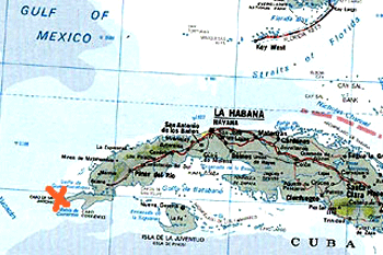
A half mile down in
the waters of Cabo de San Antonio off the western tip of Cuba's
Guanahacabibes
marked by red X is a 20-kilometer square area of
clean, white sand punctuated by tall,
megalithic stones or
structures first reported in May 2001
by Paulina Zelitsky, Ocean
Engineer, Havana, Cuba.
"They (megalithic stones) are very
unique structures. They really are not easy to understand and I
do not have any easy explanation for them in a natural
geological process."
Manuel Iturralde-Vinent, Ph.D., Geologist,
National Museum of Natural
History, Havana, Cuba
July 10, 2002 Havana, Cuba A year ago
in May 2001, I first reported at Earthfiles.com the startling
comments made by ocean engineer, Paulina Zelitsky in Havana, Cuba
about her finding earlier in 2000,
"possibly a sunken city built in
the pre-classic period and populated by an advanced civilization
similar to the early Teotihuacan culture of Yucatan.... Researchers
using sonar equipment have discovered at a depth of about 2,200 feet
(700-800 meters) a huge land plateau with clear images of what
appears to be urban development partly covered by sand. From above,
the shapes resemble pyramids, roads and buildings."
(Earthfiles May
18, 2001)
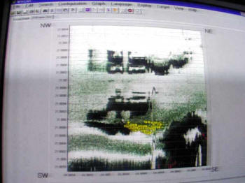
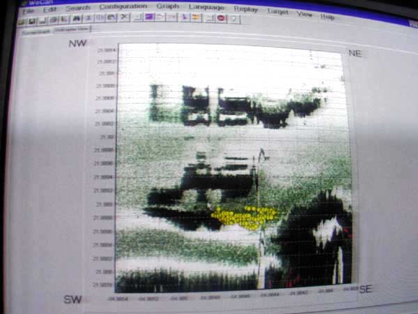
Original high
resolution sidescan sonar received by the
EXPLORAMAR expedition in 2000
directed by Paulina
Zelitsky and Paul Weinzweig
Since then, I have interviewed Paulina
and her husband, Paul Weinzweig, several times about the evolution
of their research and goal to get a specially built robot down to
the megalithic site which could have lights for videotaping and
drilling equipment to sample from the megalithic stone structures.
(See Earthfiles June 13, 2001, November 19, 2001, December 1, 2001,
December 15, 2001 and December 28, 2001.)
The couple operates the
Advanced Digital Communications known as ADC in Canada and Havana
which contracts to perform deep ocean research.
Originally, ADC had hoped to have a robot on the ocean floor by the
summer of 2002, but its cost of $2 million has been an obstacle. So
far, the National Geographic Society continues to express interest
in adding its resources and media production efforts to the
exploration, but to date no official contract has been signed. So, Paulina and Paul have taken on other assignments to pay bills while
periodically sending remote operated vehicles known as ROVs down to
pick up small rocks that lay on thick sand around the large
megalithic stone "structures."
Some of those samples have gone to geologist Manuel Iturralde-Vinent,
Ph.D., who works for Cuba's National Museum of Natural History in
Havana. Since early spring 2002, Dr. Iturralde-Vinent has studied
side-scan sonar images and videotape from the half-mile-deep site
and has concluded that he cannot assign a completely natural
geological explanation for the large, rectangular-shaped rocks that
stand up on a vast, white field of deep sand spread over 20 square
kilometers.
However, he is waiting for the first analyses of rock
samples expected around July 19th. Until then, he is reserving
opinion about the composition of the megalithic structures. However,
Paulina Zelitsky describes the structures are polished granite not
indigenous to either Cuba or the Yucatan.
This week I talked with both Paulina Zelitsky and Dr. Iturralde-Vinent about their current research and theories about
what might have happened off the extreme northwestern Cuba peninsula
known as Guanahacabibes.
Interviews:

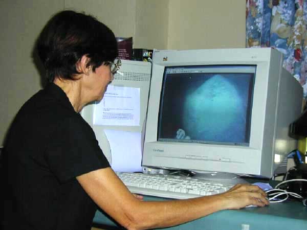
Paulina Zelitsky
at her computer in Havana studying a pyramidal-shaped stone
videotaped at the half mile deep site in July 2001 by her ADC
remote operated vehicle (ROV).
Paulina Zelitsky, Ocean Engineer,
Advanced Digital Communications, Havana, Cuba:
"Samples that we recovered from the
ocean bottom have justified our structures that we call
megalithic structures. The samples are granite stone, completely
polished, with some incrustations of fossils. Fossils of organic
creatures that normally live on the surface, not on the ocean
bottom. This is very interesting because this is evidence that
the whole surface sank to the depth of 700 meters (2,297 feet,
or about a half mile down).
The area has been seismically active for thousands of years. And
what we find on the ocean bottom are fractures from which the
magma and volcanic ash came out. From these structures we were
able to delineate a configuration of the land that sank because
you can see them clearly. The land that sank is very obvious
from our image of the ocean bottom. And you can see bays, like
harbors, and it's all at the depths of 900 and 700 meters.
Geologically, does Dr. Iturralde-Vinent and others have any
idea what happened volcanically? Was it one large eruption or
series of eruptions?
Series of eruptions and as he is saying, it is still active. A
series of eruptions that created major tectonic movement to such
a degree that land is sinking. For example, Cuba has sank and
re-emerged a couple of times! But that was long ago,
geologically. Now, what happened more recently geologically is
that land sank that joined to Yucatan islands between Yucatan
and Cuba, they sank.
Also, geologically and botanically in terms of organic life,
Yucatan and Cuba the extreme northwestern part of Cuba which
is Peninsula Guanahacabibes are completely
identical. Completely identical. It's the same limestone and the
same organic life and the same botanic and animal represented.
It's very obvious that land that was joining that is now on
ocean bottom is land that was joining Yucatan and Cuba. But this
land was sinking because of tectonic movement which were
occurring. Of course, earthquakes and volcanoes were
accompanying the tectonic movements. Tectonic movement is not
something that moves softly. It is always accompanied by
dramatic volcano and earthquake activity.
But we saw on ocean bottom where the bays and coastal lines of
the island that sank. We think there was a series of islands
between Cuba and the Yucatan. There could have been sinking
15,000 years ago.
One area between the fractures. Not on the fractures. It is
between the fractures was left undisturbed and just sank flat
without fractures. On this area, we can observe those megalithic
structures, or constructions. And they have completely different
and independent delineation from geological faults, from our
geology of the sunken land, or the geology of island Cuba.
Completely independent delineation of their own.
As if they came from some place else?
We don't know yet. But it obviously didn't come from Cuba.
That's one thing. The stone we recovered from ocean bottom is
very polished granite. All of the peninsula of northwest part of
Cuba, all of this peninsula is limestone, very fractured
limestone. So, geologically, it (megalithic granite structures)
is totally foreign to Cuba. But it's also not known in Yucatan
because Yucatan is also limestone, not granite. Granite is found
only in the center of Mexico.
It covers approximately a beautiful, beautiful, flat, clean
area. Nothing else in this area. And it covers approximately 20
square kilometers of this area. It's flat, completely flat. Huge
white silicon field. In the middle of all of that are these
megalithic structures surfacing out of it.
What is the scientific consensus so far about how 20 square
kilometers could get down a half mile?
The whole island sank. Probably what we think happened is that
Cuba and Yucatan at one historical time were both joined. But
little by little, this land was fractured into islands and sank
to the ocean bottom. So, the land on which we discovered
megalithic structures sank somewhere between 15,000 and maybe
50,000 years ago, which is quite recent geologically.
What for you is the next most important step you can take to
collect one or more samples directly from the megalithic
structures?
I wouldn't be able to do any serious work without a robot to
that is working on ocean floor because I need stability in order
to be able to make an opening in the megalithic structures. We
need to make an opening to enter. National Geographic is
interested in investigating the site with submersibles. So that
might be another opportunity.
Do the submersibles have the ability to drill into stone?
No. Submersibles don't. They just have the ability to observe
with human eyes.
Or videotape.
Or video camera, yeah. But it must be operated by humans.
If you can get the special robot constructed and down there
that costs $2 million, you would be able to photograph with good
light and be able to drill into a megalithic structure?
Oh, yes. I would be able to make opening and enter inside the
structures. What I am the most interested in doing is to enter
inside because if there are some artifacts, they should be
inside the structures and not outside.
Then if National Geographic, or other interested
organization, can get funding together, you might be able to go
forward full time on research and get the robot down to both
photograph and drill into the structures?
Yes, that's right. And discover a completely new page in our
history."
Manuel Iturralde-Vinent, Ph.D., Geologist, National Museum of
Natural History, Havana, Cuba, who presented a scientific paper
about the deep water megalithic structures in March 2002 at an
International Geophysical meeting in Havana:
"I do not yet know if the megalithic
structures are granite. I have been working with the data
provided by Paulina for three months and I have been observing
the side-scan sonar images, the video images with some samples
recovered from different places within the area with the
megalithic stones are and also from an area located to the south
of this region.
My impression is first that the structures that are in the
megalithic area at the 600 to 700 meter depths, I cannot explain
these structures by any geological means right now. So, I am not
sure that I can find a geological explanation for the origin of
these structures.
So I'm clear the structures don't fit into any natural
explanation currently?
Yeah, we think that in natural geological terms, I cannot give a
logical explanation now. So, I am not telling that they are
artificial, but what I say is right now I don't have a good
explanation as to the origin by natural cause of these
structures. They might have an artificial origin. But in this
case, we are opening into a very interesting situation because
given the depth of this structures and if we calculate the
timing when these might have been uplifted, it will take us up
to 50,000 years ago. (Meaning, when the land mass now down a
half mile might have been above sea level.)
This is if we follow the rules of the normal tectonic movement
as we have been recording them in the past 100 years in Cuba.
But these figures are well known in the world. More or less, the
sea floor can move down as quickly as 16 millimeters a year.
That's one of the very interesting issues that are related to
this discovery.
Meaning that the area is still active seismically and you are
seeing that parts of Cuba are still sinking.
Current geological knowledge and data indicates that the area is
still very active and sinking even now. We are not done with
this research. We need to still do more research, collect more
samples, provide more observation to be sure about what we are
talking about. But something is very safe to say now is that we
are not dealing with blocks that have been falling down from the
slope. They (megalithic stones) are very unique structures.
They
really are not easy to understand and I do not have any easy
explanation for them in a natural geological process. That's my
conclusion now. I need more time and more data before going
forward."
More
Information:
If any organizations or individuals are interested in helping fund
the several million dollars needed to accomplish the deep underwater
research of the Cuban megalithic site, Paulina Zelitsky and
Paul Weinzweig suggest writing to:
Sylvia Earle,
Explorer-In-Resident
National Geographic Society
1145 17th Street N. W.
Washington, D. C. 20036
|