View Part: 1 2 3 4 5 6 7 8 9 10 11 12
PART 9 - IN SEARCH OF ATLANTIS
The story of Atlantis is generally credited to Plato, even though he ascribed the story to much earlier Egyptian sources. According to those sources, the ancient, advanced Atlanteans ruled over islands and continents from an island kingdom outside of the Pillars of Hercules, which is thought to be the Straights of Gibralter. In Greek mythology, Atlas was the first king of Atlantis. Atlas had seven daughters known as the Atlantides. Because their mother was named Hesperis, they were also known as the Hesperides.
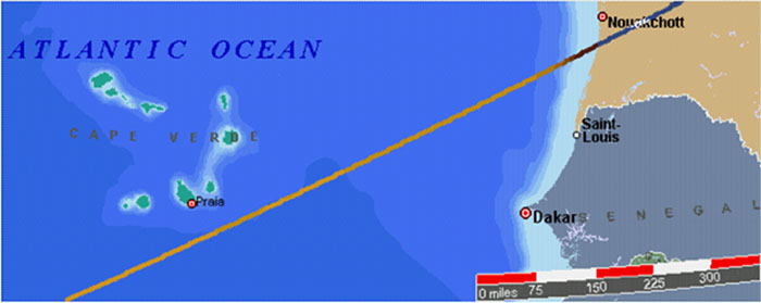
Machupicchu and the Great Pyramid are equally distant from the Cape Verde Islands. Easter Island and the Indus Valley are also equally distant from Cape Verde. When the Cape Verde Islands were rediscovered by European mariners in 1460 they were found to be uninhabited. However, islands in this location are found on earlier maps and described as inhabited in ancient times.
The Mecia de Viladestes map of 1413 shows islands in the location of Cape Verde labeled Gades. The information in this map is thought to have come from Roman sources dating back to the first century AD.
The discoveries of the world from their first originall unto the yeere of our Lord 1555, written by Antonio Galvao in 1563, lists the ancient names for the Cape Verde Islands as the Dorcades, Hesperides and the Gorgades. A 1587 map by Richard Hakluyt also labels the Cape Verde Islands as the Gorgades and the Hesperides.
According to Plato, there was a mountainous region north of the city of Atlantis. One possible location for Atlantis is in the Atlantic Ocean, just south of the Cape Verde Islands.
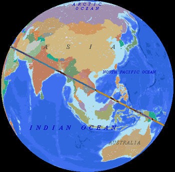
Arysio Nunes dos Santos proposed that Atlantis was originally located in the Bay of Bengal, just south of the mouth of the Ganges, and in the South China Sea. These areas were above sea level during the earth's last glaciation. The landmass that forms the shallow bottom of the South China Sea is the only known area on earth, large enough to meet Plato's description of the size of Atlantis, that sank at the end of the last ice age.
Santos argues that scientific evidence, and references in ancient writings, folklore and myths, prove that the South China Sea and the Bay of Bengal were the original sites of Atlantis and Lemuria. Santos contends that a super eruption of Krakatoa in Atlantean times destroyed Atlantis and caused the end of the last ice age by covering the earth with volcanic ash which absorbed sunlight and melted the ice.
The alignment of world wonders crosses over the Bay of Bengal, just south of the mouth of the Ganges, and goes right across the middle of the South China Sea. The halfway point betwen Mohenjo-Daro and Angkor is also located in the Bay of Bengal.
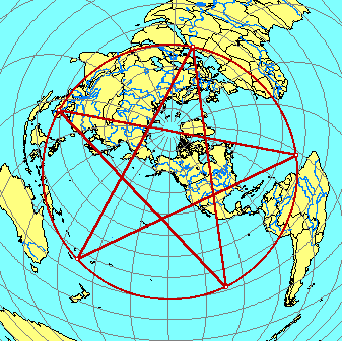
Another possible Atlantis location is halfway between the Great Pyramid and Easter Island, at 4° 19' north latitude, 41° 30' west longitude, under the Atlantic Ocean northeast of the mouth of the Amazon. On the diagram below, the marked locations are Giza, Angkor, Anatom Island, Easter Island, and 4° 19' north latitude, 41° 30' west longitude in the Atlantic Ocean.
The distance from the Great Pyramid to Easter Island is approximately 40% of the circumference of the earth. The marked location in the Atlantic is halfway between the two, 20% each way. Machupicchu is halfway between Easter Island and the marked location in the Atlantic, 10% each way. The Distance from the Great Pyramid to Angkor Wat is approximately 20% of the circumference, and the Indus Valley is halfway between the two, 10% each way.
The Distance from Easter Island to Angkor Wat is approximately 40% of the circumference, and Anatom Island is halfway between them, 20% each way. Although there are no islands in the Atlantic near 4° 19' north latitude, 41° 30' west longitude, it is interesting to note that the famous Piri Reis map shows a large island in this location, and the geology of recent core samples, taken from the ocean floor in this area, is of continental rather than oceanic type rock.