|
by Laurence Hecht
21st CENTURY
Winter 1993-1994
from
21stCenturyScienceTech Website
|
Laurence Hecht is an
associate editor of 21st Century magazine. He began
serving a 33-year sentence as a political prisoner in
the state of Virginia on Nov. 4, 1993, along with five
other associates of Lyndon LaRouche. |
We are now in an ice age and have been for about the past 2 million
years.
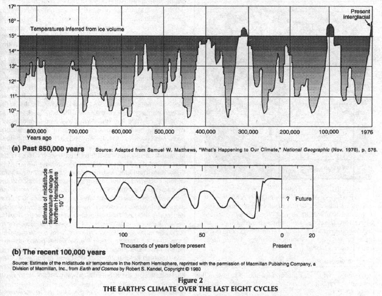
Over the past 800,000 or so years, the
Earth's climate has gone through eight distinct cycles of roughly
100,000-year duration. These cycles are driven by regular
periodicities in the eccentricity, tilt, and precession of the
Earth's orbit.
In each of the past eight cycles, a
period of glacial buildup has ended with a melt, followed by a
roughly 10,000-year period - known as an
interglacial - in which relatively
warm climates prevail over previously ice-covered northern
latitudes.
|
 |
 |
|
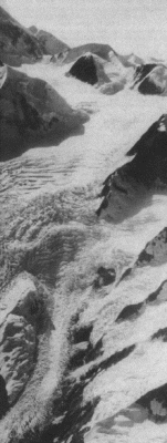
The Margerie Glacier
in Glacier Bay National Monument, Alaska,
is a typical
fast-moving mountain glacier. |
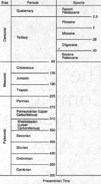
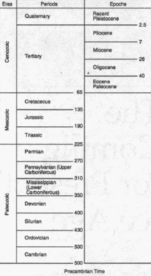
Figure 1
THE GEOLOGIC TIME
SCALE
Time units of the
geologic time scale.
(Numbers are absolute
dates in millions of years before present.) |
The present interglacial has already
lasted beyond the 10,000-year average.
One may thus suspect that a new period
of glacial advance, a new "ice age/' is in the making. Whether it
will take a few thousand years or a few hundred, or whether the
process of glacial advance is already under way is difficult to say.
Of one thing we are sure:
The present hysteria over global
warming - with its apocalyptic forecast of melting of the
polar ice caps, flooding of the coastal cities, and
desertification of the world's breadbaskets - is not helping
citizens to understand the real and complex forces that shape
the Earth's climate.
We do not wish to counter the
global-warming hysterics with a new scare tactic of our own. Nor
will we concern ourselves here with refuting every wild conjecture
put forward by the proponents of a global warming. Enough holes have
already been poked in this "theory" (really only a conjecture) to
cause honest scientists to exercise caution.1
Rather, let us take a sober look at the
long-term picture of Earth's climate that has been put together over
centuries of careful work in the fascinating and challenging
multidisciplinary science known as
paleoclimatology.
Our Present
Ice Age
At the present time, glaciers - large, slowly flowing masses of ice
formed from recrystallized snow - cover about 6 million of the
approximately 57 million square miles of land area on the Earth. At
the height of an ice age, perhaps another 8 to 12 million square
miles of land area, largely in the Northern Hemisphere, becomes
covered with a thick layer of ice and crushed snow.
The idea of large-scale glacial motion was brought to the attention
of modern science by a Swiss chamois hunter in the early 19th
century, who hypothesized that unusual striations in large exposed
rocks had been caused by the pressure of a glacier that had since
retreated up the mountain.
Louis Agassiz, the Swiss
paleontologist and associate of the famous Humboldt brothers, waged
the fight to convince the scientific community of the truth of this
hypothesis, beginning at a conference of the Swiss Society of
Natural Sciences at Neuchatel in 1837.
Northern Hemisphere glaciers have been with us only for
approximately the past 2 million years, a short stretch on the
roughly 4.6 billion-year scale of geologic time, in which our
present era, the Cenozoic, occupies the most recent 50 million years
(Figure 1 above). The Cenozoic era is divided into two periods, the
Tertiary and Quaternary, the latter of which began about 2 million
years ago with the onset of the glacial buildup.
Within our present
Quaternary period, there are two
further subdivisions known as epochs. These are the
Pleistocene, which began about 2
million years ago, and the
Holocene (or Recent) epoch, which
is roughly 10,000 to 12,000 years old. (Some paleontologists argue
quite cogently that we are still in the Pleistocene and
dispense with the designation of a Recent epoch.)
Currently, the greatest area of glaciation is the continental ice
sheet of
Antarctica (about 5.0 million
square miles), which began its expansion about 5 million years ago.
The largest Northern Hemisphere glacier is the Greenland ice sheet
(about 0.8 million square miles).
As the glaciation expands, most of the
additional growth takes place in the Northern Hemisphere.
The whole of the last 2 million years, the Quaternary period, is
considered an ice age, a relatively rare state of affairs in
geologic history. But this long-term ice age has been marked by ebbs
and flows in glacial extent. The work of the past two centuries in
climatology, paleobiology, meteorology, astronomy, geology,
geophysics, and many other fields has confirmed the existence of an
astronomically determined cyclical pattern within the Quaternary ice
age.
Driven by well-defined cycles in the
Earth's orbital orientation to the Sun, periods of roughly 100,000
years of generally advancing glaciation have been followed by short
periods, of roughly 10,000 years' duration, in which the glaciers
retreat.
These two periods or subdivisions of the
ice age are known as glacials and interglacials.
The 100,000-year periods are not one
continuous downward slope of temperature and glaciation, but are
modulated by roughly 20,000-year cycles, consisting of 10,000 years
of cooling and glacial advance followed by 10,000 years of warming
and retreat.
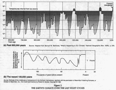
But these shorter-term ups and downs of
the glaciation curve tend to get cooler and cooler as the
100,000-year cycle advances (Figure 2 above).
The maximum extent of glaciation, the
glacial climax of the last 100,000-year ice age, occurred just
18,000 years ago, at a time when human societies were already well
established on the Earth.
At that time, a huge continental glacier
covered North America down through the northeastern states of the
United States, reaching across the mid-western plains and up into
Canada (Figure 3).
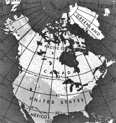
Figure 3
THE LAST GLACIATION
IN NORTH AMERICA
The maximum extent of glaciation occurred just 18,000 years ago and
was known in North America as the Wisconsin.
The dotted white
areas show this huge glacier that covered the northern area of the
continent
and parts of the
western mountain ranges. White areas show today's glaciers.
Source: U.S. Geological Survey
This most recent of the great
continental glaciations is known in North America as the Wisconsin
(in Europe as the Weichselian).
Its southernmost limit extended across
the middle of Long Island, through northern New Jersey, lower New
York State, western Pennsylvania, Ohio, Indiana, Illinois, Iowa,
then up diagonally through the northeastern corner of Nebraska, into
the Dakotas, and across the southern tier of the Canadian plains.
In more southerly regions, mountain glaciers also spread downward
from heights in the Colorado Rockies, the Sierra Nevadas, and the
Cascade Range. In western Europe, the glacier reached down from
Scandinavia over northern Germany, Poland, and the Baltic nations.
It reached deep into Russia and Ukraine south of Kiev, and eastward
as far as the central Siberian Plateau. It stretched southwestward
over the Netherlands and covered Ireland and most of the British
Isles. A separate portion extended outward from the Alps and another
one from the Caucasus Mountains in Asia Minor.
An Arctic climate thus prevailed over much of what are now the major
population centers of western and central Europe and the United
States. The weather over most of the remaining portions of the three
northern continents was quite a bit colder than today's. But hunting
was apparently good along the fringes of the continental glaciers,
and man survived in these regions in a fairly primitive state,
wearing animal furs for warmth and seeking shelter in caves.
The changes wrought in geography during the several-thousand-year
period of retreat of that glacier were enormous. It is somewhat
shocking to realize that major topographical features on the map of
the United States are only about 12,000 years old. Before the
completion of the glacial retreat, there were no Great Lakes, for
example.
None of the many lakes, large and small, that dot the
northern tier of the United States existed. Other lakes - such as
the 20,000-square-mile Lake Bonneville that once covered much of
Utah - dried up, leaving behind only a few relatively smaller
remnants, like the Great Salt Lake.
The rivers that emerged after the retreat were not the same as those
that had been there 100,000 years earlier, before the glaciation.
The northern Missouri River, for example, drained northward into
Hudson Bay, and what is now the upper Ohio flowed northeast into the
Gulf of St. Lawrence.
The lower Ohio drained into a now
nonexistent river, which geologists have named
the Teays.
Where Are We Now?
We are currently beyond the expected end-point of an interglacial
period that began more than 10,000 years ago. We are thus at a point
on the paleoclimatic timetable where the onset of a new 100,000-year
ice age is expected and may even be already in progress.
The global climate has been generally
cooling over the past 6,000 to 8,000 years, and is now about 1
degree Fahrenheit cooler than at the time of the postglacial
climatic optimum. One might cite evidence such as the advance of the
Greenland ice sheet and the southward movement of the limit of
citrus growing in the southeast United States over the past 40 years
to suggest that the expected cooling is even now under way.
However, because these astronomically
driven cyclical trends are of long duration (10,000 years being the
shortest cooling cycle), it is not possible to attribute a climatic
trend on a time span so short as a few decades or even a few
centuries to a single cause. One must take a broader view.
The melting of the glaciers that had formed during the last
100,000-year ice age cycle took a long time, and the rate of melting
was varied. The North American Laurentide ice sheet was the last to
retreat. If we date the beginning of postglacial (interglacial)
times to a point roughly 10,000 years ago (c. 8000 B.C.), it is then
useful to look at the climate, especially temperature trends, over
this recent 10,000 years. Following a number of short-term
oscillations beginning about 12,000 B.C., a rise in temperature that
set in about 8300 B.C. led to sustained warm climates in the
northern European lands formerly covered by ice.
The maximum summer temperatures
experienced in Europe over the last 10,000 years occurred in about
6000 B.C. over North America, where the process of glacial retreat
lagged somewhat, the maximum was reached by about 4000 B.C. That
period is known as the
Postglacial Climatic Optimum (or the altithermal period) when mean temperatures were about 1 degree
Fahrenheit warmer than today.
Beginning about 3500 B.C., a sharp reversal known as the
Piora
oscillation set in, marked by advance of the glaciers in Europe and
large-scale migration of agricultural peoples. From 3000 B.C. to
1000 B.C., the climate regained some of its former warmth but was
apparently subject to recurrent fluctuations, particularly in
rainfall.
From 1000 to 500 B.C., the glaciers
advanced again. In Europe the most marked change appears from 1200
B.C. to 700 B.C., coinciding with the Dark Age period that Homeric
scholarship suggests occurred in Greek-speaking lands. In some
places (Alaska, Chile, China) there is evidence that the cooling and
re-advance of the glaciers began as early as 1500 B.C.2
A period of warmth and higher sea level came to Europe around the
year 400 followed by another reversion to colder and wetter
climates. This was again reversed, and there was a very warm period
that culminated in Greenland about 900 to 1200 and in Europe 1100 to
1300. Known as the
Medieval (or Little) Climatic Optimum,
temperatures in this period became, briefly, nearly as warm as in
the postglacial climatic optimum.
As historical climatologist H.H. Lamb describes it:
Oats and barley grew in Iceland. The
limit of tillage in northern England, Wales, the Scottish
highlands, in central Norway, and in high regions of central
Europe was extended hundreds of meters up the hills and
mountainsides. Mining operations were begun high in the Alps.
Norse colonists were catching cod in the sea off western
Greenland, and a regular northern sea route developed to North
America.
In the Mississippi valley, peoples were
moving northward into Wisconsin and eastern Minnesota, and human
settlements spread up the valleys of all the major rivers.
Renewed moisture in North Africa allowed
cattle to thrive in now-arid regions, and journeys across the desert
from North Africa to Ghana, Mali, and Kufra are described by the
Arab geographers between the 11th and 14th centuries.
This warming period, which ended as early as 1100 in parts of North
America and later in Europe, was followed by a roughly 500-year
period of severe cooling known as the
Little Ice Age - the
Klima-Verschlechterung, or climate-worsening in the German
literature.
The low point of the cooling occurred
from about 1550 to 1750, but extreme cold weather began earlier and
ended considerably later in many parts. The Greenland colony, for
example, died out not long after the year 1400. And in England, tent
cities were set up and Frost Fairs celebrated on the frozen river
Thames as late as the winter of 1813-14.
Some of the symptoms of the cooling as
described by Lamb were:
-
advance of the inland ice and
permafrost in Greenland and of the glaciers in Iceland,
Norway, and the Alps
-
spread of Arctic sea ice into
the north Atlantic around Greenland, forcing abandonment of
the sailing routes used from the year 1000 to 1300
-
lowering of the tree-line in
central European highlands and in the Rockies, spread of
lakes and marshes in Europe and northern Russia, swollen
rivers and increasing frequency of landslides
-
increasing frequency of freezing
of rivers and lakes
-
increasing severity of
windstorms and sea floods
-
harvest failures and rising
prices of wheat and bread
-
abandonment of tillage,
vineyards, and farm villages
-
increased incidence of disease
and death among human and animal populations.
The Conditions
for an Ice Age
From the long-range view of the geologist, the last 2 million years
of glacial climate conditions are not the global "norm." Only two
times in the 600 million year near-term geologic record have the
conditions been ripe for an ice age: once in the Permian period of
the Paleozoic era, about 250 million years ago, and once more in the
present Quaternary period.
There are two basic requirements for an ice age:
-
First, a
configuration of the continents that places a large portion of the
land mass in polar and non-tropical regions.
-
Second, a climate in the higher latitudes characterized by wet,
snowy winters followed by summers cool enough to not reduce the
glacial advances made the previous winter.
Although the causes that give rise to these two conditions are
complex and far from perfectly understood, the recognition of their
importance and of some of the basic mechanisms governing their
genesis dates to no later than the early part of this century.
Subsequent advances in nearly all the physical sciences and the work
of thousands of researchers in the many fields related to historical
climatology have greatly enhanced our understanding and
documentation of the climate record.
But the big challenge, to understand
climate well enough to be able to predict its future course, is
still out of reach.
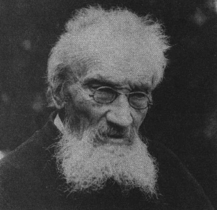
The Köppen-Wegener
Connection
If the name of a single person were to be identified with the birth
of the modern science of paleo-climatology, it would be one that is
little known, even to many specialists in the field: Vladimir
Köppen (1846-1940).
The St. Petersburg-born meteorologist
came from a German family that had settled in Russia during the
reign of Catherine II. He began his study of natural sciences in
Heidelberg in 1866 and received his doctorate in 1870 with a paper,
published in Moscow, on the effects of heat on plant growth. After a
brief period of work at the Central Observatory in St. Petersburg, Köppen came to the
German Marine Observatory in Hamburg where he
stayed for 44 years, becoming first the head of the weather service
and then meteorologist of the observatory.
Köppen's list of publications numbers 526 items. Of these, probably
the most important for today is the one he coauthored with his son-inlaw, Alfred Wegener, in 1924, Die Klimate der geologischen
Vorzeit (The Climates of the Geological Past).
Alfred Wegener (1880-1930) is known to students of the earth sciences
today as the father of the modern theory of continental drift.
|
 |
 |
|
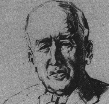
Climatologist Vladimir Koppen, Alfred Wegener's father-inlaw
and collaborator, at the age of 78
by Ε.
Kuhlbrodt |
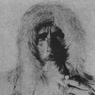
Alfred
Wegener in Greenland
"Die
Weissewüste" by K. Aerdemerten |
Wegener's now famous theory was initially rejected by the science
establishment, and became widely accepted only in the 1960s and
1970s, well after his tragic death on the Greenland glacier in 1930.
It is far less well known that Wegener and his father-in-law Koppen
were also leading proponents of the modern theory of astronomical
determination of the ice age cycles.
The two theories - continental drift and the determination of the
ice ages by the cycle of
solar insolation - had a common
thread. In the minds of Wegener and Köppen they were really one
grand conception. The first theory began with Wegener no later than
1910.
It is recorded in a charming letter to
his wife:
"Doesn't the east coast of South
America fit exactly against the west coast of Africa, as if they
had once been joined? The fit is even better if you look at a
map of the floor of the Atlantic and compare the edges of the
drop-off into the ocean basin rather than the current edges of
the continents. This is an idea I'll have to pursue." 3
The idea itself was not new; it had been
noted in Alexander von Humboldt's famous Cosmos, among other
locations.
But Wegener had at his command the extensive researches of the
previous century, which included data of both a geologic and
paleobiology sort, suggesting the possibility that the continents
had once been linked. The similarity of South American and African
fossils and the close relationship of flora and fauna of many
regions separated by oceans had already been noticed by
investigators.
One prominent attempt at an explanation
was the hypothesis that land bridges had once existed, for example,
connecting South Africa with southern South America, North Africa
with Florida and the Caribbean, and so forth.
Twenty years before Wegener, the great
Viennese geologist Eduard Suess had proposed that the
continents may have been linked together in one supercontinent,
which he called
Gondwanaland. The similarity in
geological development of the continents of the Southern Hemisphere
(including the Indian subcontinent), and their marked difference
from those of the north, had already suggested some such link.
But Suess was not sufficiently versed in
these fields to recognize the paleobiological and climatological
significance of his hypothesis.
Wegener drew on Suess's differentiation of the two major types of
rocks
sial (for silicon-alumina) and
sima (for silicon-magnesia) that
make up, respectively, the bulk of the crustal material of the
continents and the ocean floors.
The sial, which corresponds most closely to granite, has a specific
gravity (a measure of its weight in comparison to an equivalent
volume of water) of 2.7, while the sima, which is like basalt, is
somewhat heavier at 3.0.
Thus the lighter rock making up the
continental crust could be thought of as formed into giant blocks
floating, somewhat like icebergs, above the denser sima.
Wegener's drift hypothesis was first presented in Frankfurt-am-Main
on Jan. 6, 1912, at the annual meeting of the Geological
Association. The first book-length account, Die Enstehung der
Kontinente und Ozeane (The Origin of the Continents and Oceans),
appeared in 1915. Here and in his other early papers, Wegener was
somewhat at a loss to explain by what mechanism the drifting apart
of these blocks would occur.
In 1929, he tentatively proposed the
answer accepted today, referring to the possibility of convection
currents in the magma - the layer of molten rock on which the
Earth's crust is thought to float. The high mountain ranges found
near the edge of continents - the Alps, Himalayas, and the
Cordilleras, which range from Alaska to southern Chile - were seen
as produced by the crumpling up of layers of rock on the leading
edge of the drifting continents, produced by forces similar to that
of a bow wave.4
Together, these ideas condensed in the notion that the continental
blocks had once been united in a single great continent, called
Pangaea, and had subsequently
drifted apart, taking up various configurations before arriving at
the one we know today. In its details, the Wegener hypothesis also
went a long way toward explaining some of the climatic anomalies in
the fossil record and other paleobiology evidence from widely
varying places on the Earth.
A snapshot summary of the modern
reconstruction of the theory of drifting continents can be seen in
the map series showing reconstructions of the global map at major
points on the geologic time scale (Figure 4).
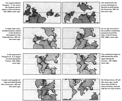
Figure 4
Ice ages occur not
because the Earth as a whole is plunged into a deep freeze
with ice extending
down to the equator, but because in the Earth's evolution,
the slow
process of continental drift carries continents to high latitudes,
where snow can fall
and build up into great ice-sheets.
Source: From The Weather Book by Peter Wright, Ralph Hardy, John
Kingston, and John Gribbin.
1982 by Harrow House.
The Solar
Astronomical Cycles
In 1910, the same year that Wegener was formulating the theory of
continental drift, his father-in-law, Koppen, was musing over the
earlier research of glaciologists Albrecht Penck (1858-1945)
and Eduard Brückner (1862-1927), Die Alpen in Eiszeitalter
(The Alps in the Ice Age).
Through their extensive fieldwork in
Alpine regions, Penck and Brückner had been able to distinguish four
separate cycles of glacial advance and retreat over the ages, and
they produced a climatic curve for the ice age.
Köppen conceived the
idea of superimposing on this curve the time-scale produced by
examining the changes in insolation caused by regular cycles in the
Earth's orbital relationship to the Sun. Köppen's hope was that the
cycles of glacial advance and retreat could be dated by correlating
them to the astronomical cycles.
The idea of a correlation between long-term changes in climate and
the solar-astronomical cycles goes back to a hypothesis put forth in
1830 by Sir John Herschel, the son of the great astronomer
Friedrich Wilhelm Herschel and a leading figure in 19th-century
British science. Herschel thought that the 21,000year cycle of
seasonal predession of the equinox might have a determining effect
on climatic history.
His hypothesis was taken up and
elaborated first by the French mathematician J.F. Adhémar in
1842, and then by the self-taught Scottish climatologist James
Croll beginning in 1860, who added into his calculations the
cycle of change of the eccentricity of the orbit. However, at the
end of the 19th century, the exact periodicity and extent of this
cyclical variable had not been precisely calculated.
Croll was also hampered by his incorrect
supposition that periods of ice buildup would coincide with the
harshest winters.
It has since been deduced that mild
summers, in which the glacial advance of the previous winter's snow
is not erased, are more important than the harshness of winter.
Nevertheless, against great opposition,
Croll defended the hypothesis first advanced by Herschel into the
end of the 19th century. In 1910, when Koppen and then Wegener took
it up again, it was neither a popular nor a widely accepted
hypothesis.
Milutin Milankovitch,
the Yugoslav
climatologist who calculated the astronomical cycles.
Milutin Milankovitch
But one man, Milutin Milankovitch (1879-1958), a skilled
mathematician from the University of Belgrade, had independently
begun his own investigation of the astronomical theory of climate.
From 1911 until his first contact with
Koppen in 1920, Milankovitch carried out painstaking calculations of
the long curve of the variability of solar insolation (the amount of
sunlight) at northern latitudes, in hopes of demonstrating its
forcing effect on the ice age cycles (Figure 5).
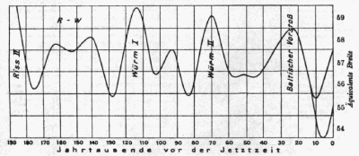
Figure 5
MILANKOVITCH'S
RADIATION CURVE FOR THE LAST 190,000 YEARS
This radiation curve by Milankovitch was reproduced by Koppen and
Wegener
in their book Die
Klimate der geologischen Vorzeit (The Climates of the Geological
Past),
a pioneering work in
paleoclimatology published in 1924.
The horizontal axis
shows years from present; the vertical plots fluctuations in
radiation.
He published a few small papers on his
work and then, in 1920, a book in the French language, The
Mathematical Theory of Heat Phenomena Produced by Solar Radiation,
which came to the attention of Koppen.
In that work, Milankovitch spelled out his theory of astronomical
rhythms, carefully determining the effect of three major cyclical
variables:
-
the 26,000year period of the
precession of the equinox, which, when combined with the
advance of the perihelion, the point at which the Earth is
closest to the Sun, produces a 21,000year cycle
-
the 40,000year cycle of
variation of the
obliquity of the ecliptic (the tilt of the
Earth's axis), which varies from 22 to 24.5 degrees
-
the 90,000 to 100,000year cycle
of variation of the eccentricity of the Earth's elliptical
orbit
A postcard from Koppen initiated an
extended correspondence between the two men.
Milankovitch, who hoped to use his
calculations to produce a curve of past climates, was troubled by
the question of which season and which latitude was most critical to
the advance of glaciation. One of the important fruits of the
exchange was Köppen's conclusion that it is the diminution of summer
heat - not the increase of winter coldness, as Croll had thought -
that is most important to the ice buildup.
At the encouragement of Koppen, Milankovitch calculated the effect
of the three astronomical cycles on Northern Hemisphere glaciation
for 650,000 years into the past and 160,000 years into the future.
This came to be known as the
Milankovitch-cycle theory of climatic history.
In a popular book
published in Leipzig in 1936, Milankovitch described his theory and
his close collaboration with Koppen and Wegener in the form of
letters to an imaginary girlfriend, Durch Feme Welten und Zeiten...
(Through Distant Worlds and Ages: Letters from an Ambler through the
Universe).5
|
What's Wrong with
Global Warming Theory?
Martin Schwarzbach
1986
from "Alfred
Wegener - The Father of Continental Drift"
Everyone would like to know what the temperature will be
tomorrow and some far-sighted people wonder what it will
be like fifty, one hundred, or even thousands of years
into the future. The only honest answer is that we
really do not know.
As indicated by the fluctuations and sometimes rather
rapid reversals of global and regional climate briefly
documented here, it is not possible to draw competent
conclusions from trends of a few decades, or even
centuries concerning the direction of climatic trends.
It is certainly not possible to forecast future climates
on the basis of one parameter (C02 density).
What the historical record does tell us is that we are
in a secular tendency toward a new glaciation.
To propose - as
does the currently popular Malthusian fad known as
'global warming' - that we are moving into a period of
substantial glacial melt and sea-level rise runs counter
to the evidence and the conclusions of more than two
centuries of scientific work.
It is sufficient to point out a few anomalies to call
the whole global warming conjecture into serious doubt:
-
The Greenland
ice sheet and snow buildup in Antarctica have
recently advanced.
-
Since 1980,
there has been an advance of more than 55 percent of
the 625 mountain glaciers (Austria, Switzerland,
Italy, Iceland, United States, and Soviet Union)
under observation by the World Glacier Monitoring
group in Zurich. (From 1926 to 1960, 70 to 95
percent of the monitored glaciers were in retreat.)
-
The limit of
the citrus-growing region in the U.S. Southeast has
moved southward, and the U.S. Department of
Agriculture has revised its hardiness zones
southward.
On Temperature
Increases
The often cited figures for the current
warming trend show a rise in mean global temperature of
about 1 degree F since 1880.
However, these data
are somewhat suspect. A great deal of statistical
manipulation is required to try to discount the warming
caused by urbanization around the monitoring stations.
What one should bear in mind is that the global climate
in 1880, including the Northern Hemisphere was
exceptionally cool.
Thus the curve
starts from a point in time when temperatures were
unusually low, which exaggerates the warming effect.
Furthermore, the
global temperature curve shows warming from 1880 to
1940, cooling from 1940 to 1976, and renewed warming
from 1976 to the present - the net rise being 0.5
Celsius or about 1 degree Fahrenheit.
The point should be
made that most of this 'warming' took place in the first half of the century
before widespread use of fossil fuels (and increased
carbon dioxide emissions).
Moreover, the recent global temperature increase has
occurred over tropical regions.
As atmospheric
scientist Hugh Ellsaesser points out (21st
Century, Winter 1991, p. 53):
"While the
warming up to 1940 was greatest in the North
Atlantic and in winter, the more recent warming
since 1976 has been greatest in the tropics, and
some of the earlier warming in the North Atlantic
has gone away."
These are
conditions that can and apparently do favor advance of
glaciation.
Regarding measurement of carbon dioxide and our
understanding of its role in the atmosphere, one should
consider the following:
-
Estimates of
the pre-industrial levels of C02 are
subjective. Nineteenth century measurements of C02
were carried out with error factors of up to 100
percent.
-
The Mauna Loa
observatory in Hawaii is considered an ideal site
for C02 monitoring. However it is also
near the site of an active volcano whose C02
emissions must be "edited" from the data.
-
The
concentrations of C02 in air bubbles
trapped in ice are often taken as previous
atmospheric concentrations, which assumes that the
air's composition remains unchanged. However,
studies show that C02 content in ice can
be greatly enriched or depleted in comparison to
original atmospheric levels.
-
The out-gassing
of CO2 from the Earth's mantle annually
is 10 times that of man-made sources, and the C02
exchanged annually between the ocean and the
atmosphere is much greater than that. If all the
Earth's fossil fuels were burned it is likely that
the C02 produced would be dissolved in
the ocean, before reaching an atmospheric
concentration double current C02 levels.
It is not out of
the question that a short-term, counter-cyclical trend,
such as the conjectured warming caused by human
production of C02 and other greenhouse gases
(of which water vapor of natural origin is by far the
most prevalent), might
disrupt a longer-term cooling trend. But this must be
proven, as it has not been.
Any competent scientific discussion of the 'global
warming conjecture' would have to be located in the
context of the secular tendency toward an ice age.
The global warming
case has not been put forth as science, however.
Instead, what has been set before the public are scare
scenarios of massive polar ice melt, sea level rise, and
catastrophic flooding for the coastal regions, combined
with heat and drought conditions over large parts of the
rest of the globe.
This is not science
but intellectual dishonesty bordering on fraud. |
Wegener's theory of continental drift, the Milankovitch theory of
astronomical cycles was not widely accepted by the scientific
establishment.
Nevertheless, a number of
paleoclimatologists in America and Europe took it up and carried out
pioneering work from the 1930s onward, which tended to corroborate
the Milankovitch cycles. Much of this was in the field of
paleobiology, examining core samples from various marine basins
under the microscope, using innovative means of dating the biota and
determining sea levels and temperature levels coinciding with the
time of their formation.
Although Milankovitch was still fighting an uphill battle at the
time of his death in 1958, today his general theory is widely
accepted. Deep-sea core samples taken in the 1970s showed the
Milankovitch 20,000, 40,000, and 100,000-year periodicities going
back for 1.7 million years.
The new work was reported in Science
magazine in 1976 in a paper written by a team of young
researchers at Columbia University's Lamont-Doherty Geological
Laboratory.6 Somewhat ironically, the geology department
at that university had been one of the staunchest holdouts against
Wegener's theory of continental drift.
Dr. John Imbrie, who ran the computer programs analyzing the
data, was the first to hypothesize that the evident periodicities
were caused by the Milankovitch cycles. He found that the
100,000-year cycle was predominant.
(Milankovitch had expected that
the 40,000-year cycle of the angle of obliquity would be the
dominant one; it was for the periods before about 800,000 years ago.
But since that time, for reasons not yet fully understood, the
100,000-year periodicity has become dominant.)
To understand the
solar astronomical cycles, which are one of the
foundations of the scientific theory of climate history, we need
only examine some of the key geometric features of the Earth's
elliptical orbit.
Johannes Kepler's discovery in
the early 17th century that the planets move in ellipses about the
Sun, with the Sun at one focus, and his elaboration of the laws of
this motion are the basis of all astronomical hypothesis concerning
climate.
(Wegener, in fact, had studied classical
astronomy and wrote his dissertation at the University of Berlin on
the subject "The Alphonsine Tables for the Use of a Modern
Calculator," a recalculation of the old tables used to ascertain the
positions of the Sun, Moon, and the five then-known planets.)
Geometry of
the Solar Cycles
Let PQ'AQ represent the elliptical orbit of the Earth around the Sun
at S (Figure 6).
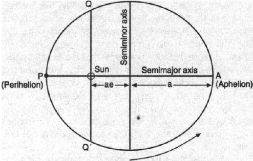
Figure 6
ORBITAL MOTION OF THE
EARTH AROUND THE SUN
Looking down upon the North Pole of the
Earth, the orbital motion is counter-clockwise from Ρ to Q' to A to
Q and back to Ρ again.
We have exaggerated the ellipse in order to
simplify visualization of the processes described. As the Sun sits
at one focus of the ellipse, the distance from Earth to Sun is least
when the Earth is at P, the position known as perihelion, and
greatest at A, the aphelion.
Let us examine the change in the amount of solar radiation that will
be received as the Earth moves from aphelion to perihelion. (The
radiation received at the edge of the Earth's atmosphere is known as
insolation.)
An ellipse is completely described by
two parameters, the length of its semi major axis, a, and the value
of the eccentricity, e, which is the factor by which a is multiplied
to find the foci. Measuring from the center of the ellipse (where
the semimajor and semiminor axes cross), a focus is located at a
distance ae along the semimajor axis. The eccentricity e is thus
always a number between 0 and 1.
With this in mind, we see that the perihelion point, P, sits at a
distance (a - ae) from the Sun while the aphelion, A, is at the
distance (a + ae). If, to simplify, we let a = 1, then the distances
from the Sun are:
Now, since the intensity of light varies
as the inverse square of the distance from the source, the
insolation at A and Ρ will be:
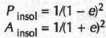
And the difference of the two is:
This is the maximum variation of
insolation between perihelion and aphelion. Since for small
values of e the denominator differs insignificantly from 1, the
value 4e provides a very good approximation for this flux
difference.
The present value of eccentricity for the Earth's orbit is 0.017,
and the variation in insolation thus comes to 0.068, or
approximately 7 percent. But the orbital eccentricity is known to
pass through a complete cycle in approximately 94,000 years, varying
from near 0 (a circular orbit) to 0.07. At the latter value, the
difference in insolation between aphelion and perihelion
becomes 28 percent.
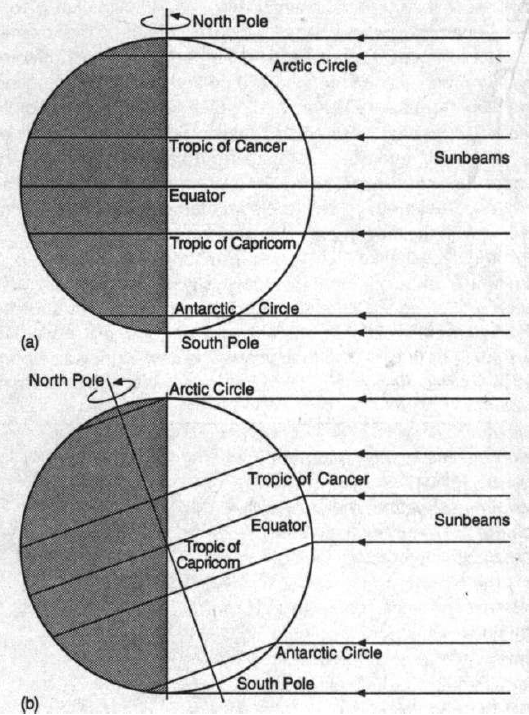
Now, the Earth is not simply a moving point, but a solid body of
more or less spherical shape. It rotates about an axis that is
inclined to the plane of the ellipse by a certain angle known as the
angle of obliquity. It is this inclination of the Earth's axis,
which is now about 23.5 degrees, that causes the main difference in
temperature between polar and equatorial regions.
The flux of the Sun's rays striking the
Earth obliquely is spread over a greater surface area than that of
the rays that strike in a more perpendicular direction.
Even without that obliquity there would
be some variation in temperature between pole and equator, because
of the changing angle at which the parallel rays of the Sun will
strike the circular arc that represents the Earth's surface (Figure
7).
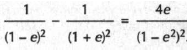
Figure 7
OBLIQUITY AND
INTENSITY OF THE SUN'S RAYS
Even without a tilt of the axis, the variation in angle of incidence
of the Sun's rays (a) would cause the poles to be cooler.
Increasing the angle
of obliquity spreads the effect (b).
An increase in the angle of obliquity
tends to exacerbate this effect.
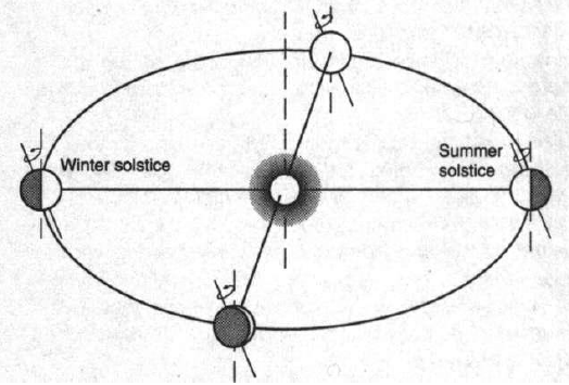
Seasonal change, that is the yearly
passage through spring-summer-fall-winter, is caused by the combined
effect of the orbital inclination and the yearly revolution of the
Earth around the ellipse.
In the course of a year, the Earth's axis
of rotation will point to the same approximate direction in the
distant sky, no matter where on the ellipse we find ourselves
(Figure 8).
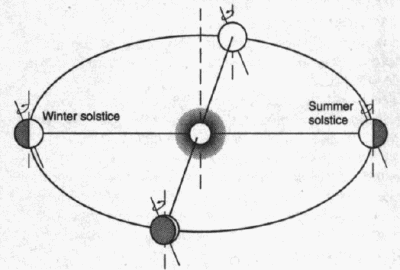
Figure 8
SEASONS AND OBLIQUITY
Seasonal change
results from the combined effect of the orbital inclination and the
yearly revolution of the Earth around the ellipse.
When the Earth's spin
axis is pointed away from the pole of the ecliptic, the Northern
Hemisphere has its shortest day (winter solstice),
while the Southern Hemisphere has its longest day (summer solstice).
However, in one annual revolution around
the Sun, the axis will take up all orientations with respect to the
line perpendicular to the plane of the ellipse and passing through
the center of the Sun, which is known as the pole of the ecliptic.
When the Earth's spin axis is pointed
away from the pole of the ecliptic, the Northern Hemisphere
experiences its shortest day, known as the winter solstice. On the
same day, the Southern Hemisphere experiences its longest day, the
summer solstice. The opposite situation occurs at the position 180
degrees around the ellipse.
If the axis of the Earth had no motion of its own, the seasons would
always occur at the same points in the orbit. But the direction in
the sky to which the Earth's axis of rotation points varies on a
cycle of approximately 26,000 years.
In the course of that cycle, the spin
axis makes a complete rotation around the pole of the ecliptic, one
obvious consequence of which is a change in the pole star (Figure
9).
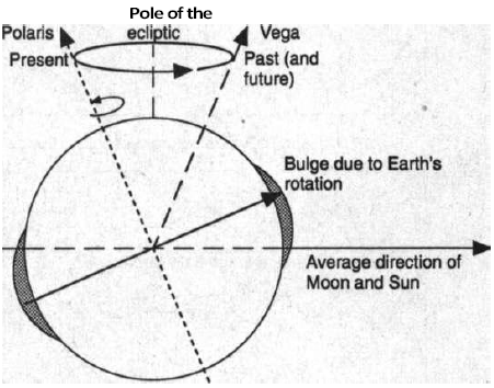
Figure 9
PRECESSION AND CHANGE
OF POLE STAR
The Earth's spin axis makes a complete rotation around the pole of
the ecliptic in a cycle of approximately 26,000 years.
The pole star is now
Polaris, but about 13,000 years ago it was Vega.
Another consequence, which was noted by
the ancient astronomers, was the long-period change of that
constellation in which they observed the Sun rising on the day of
the vernal (spring) equinox.
Later comparison of the physical
dynamics of this phenomenon to the precession of a spinning top (the
wobbling as it winds down) led to the name precession of the equinox
for the 26,000-year cycle.
As a result of this phenomenon, we must take into account where on
the ellipse the winter and summer solstices occur. When the Earth is
at Ρ in Figure 6 (far above) and the axis is turned 180 degrees away
from the Sun, we will have winter in the Northern Hemisphere. That
was the situation in approximately the year 1250.
Today we have moved a bit on the
precession cycle and find the Northern Hemisphere winter occurring
at roughly the position shown in Figure 10.
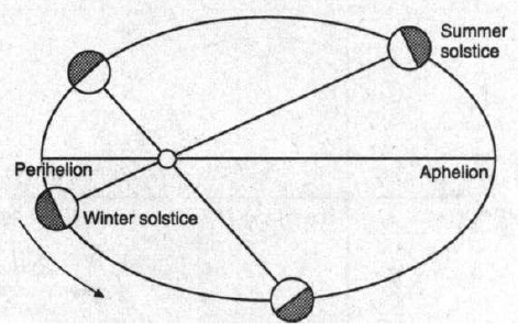
Figure 10
PRECESSION AND LOCATION OF THE SOLSTICE
The precession cycle changes the location on the ellipse where the
winter and summer solstices occur.
The approximate
positions on the ellipse are shown for the solstices today.
In addition to the phenomenon known as
precession of the equinox, the perturbations in the Earth's orbit
caused by the motion of the other planets, most notably Jupiter,
cause a phenomenon known as precession of the orbit, or advance of
the perihelion.
The result is that the complete cycle of
return to the position where Northern Hemisphere winter occurs at Ρ
takes approximately 21,000, not 26,000, years (Figure 11).
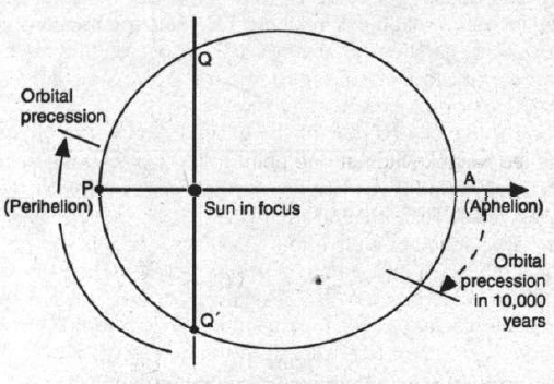
Figure 11
ADVANCE OF THE PERIHELION OR ORBITAL PRECESSION
Perturbations in the Earth's orbit, the result of the motion of the
other planets (in particular, Jupiter)
cause a phenomenon
known as advance of the perihelion or precession of the orbit,
in which the
complete cycle of precession takes approximately 21,000 years, not
26,000.
Recalling that the most important
astronomical requirement for glacial advance is a string of mild
summers in which the winter snow buildup is not completely erased by
melt, we are now in a position to examine how the orientations of
the orbit might contribute to meeting this need.
Astronomy and Climate
It might at first appear that the occurrence of Northern Hemisphere
summer at A, combined with a relatively high eccentricity, would
produce the most favorable conditions.
However, we have yet to take one other consideration into account.
The rate of motion of the Earth in its elliptical orbit is not
uniform.
As Kepler was able to demonstrate, the planets move more
swiftly when near to the Sun at position Ρ than when at position A.
He was able to define the rate of change of velocity as such that
the radius vector of the moving planet sweeps out equal areas on the
surface of the ellipse in equal times (the
Equal Area Law).
The case is illustrated for an ellipse
of high eccentricity (e = 0.5) in which the planet's motion in
one-tenth of a year is marked out in portions of the orbit near
perihelion and aphelion (Figure 12).
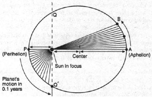
Figure 12
INSOLATION AND THE EQUAL AREA LAW
As Kepler demonstrated, the rate of motion of the Earth in its
elliptical orbit is not uniform:
Planets move more
swiftly when near to the Sun at perihelion than when at aphelion.
In this ellipse of
high eccentricity, e = 0.5,
the planet
takes the same time to move from aphelion to Β as it takes from
perihelion to Q'.
The rate of change of
the angle that the radius vector makes with a fixed direction
is inversely
proportional to the square of the distance between the Sun and
planet.
This is the same law
that describes the diminution of insolation with distance.
When this variation in time is analyzed
more closely, it is found that the rate of change of angle that the
radius vector makes with a fixed direction is inversely proportional
to the square of the distance between the Sun and planet.
Thus, the same mathematical law that
describes the diminution of insolation with distance also
describes the diminution in rate of change of the angle of the
radius vector.
The consequence is that the planet intercepts the same quantity of
solar radiation for each degree of angular rotation, although it
passes through each degree of rotation at a varying rate. Thus, if
the orbit is divided up into four quadrants, such as by the points
P, Q', A, Q and the lines connecting them to the Sun, the planet
will receive exactly the same insolation in all four
quadrants.
The trick is to recognize that the time
spent in the two larger quadrants that surround A is longer than
that spent in the two smaller quadrants that surround P. Thus, the
same insolation is received over a longer number of days in
the two larger quadrants and its flux density per day is
consequently less.
If winter solstice occurs at P, climatologists call the two smaller
quadrants caloric winter and the two larger ones caloric
summer. One sees then that another way of describing the
condition described above is to say that the summer is longer and
milder (at least with respect to solar insolation) than
winter.
The difference in length between caloric
summer and winter can be as great as 33 days. At the present time,
the difference is 7 days. This will vary with the eccentricity,
which, as we have mentioned, has a cycle of about 94,000 years.
As the position of the winter solstice moves around the ellipse, a
pair of perpendicular lines drawn through the Sun will always
describe the four seasonal positions. Thus it can be seen that a
cycle of 21,000 years' duration will be superimposed on the longer
cycle of 94,000 years' duration. Let us suppose, for example, that
we begin at a point in time when the winter solstice is at Ρ and the
orbital eccentricity is at a maximum.
The greatest excess in the number of
days of caloric summer over winter will then be experienced, and
consequently the lowest flux density of the summer insolation.
Assuming the proper meteorological dynamics, this should be an ideal
position for the rapid advance of glaciation.
Let the rotational axis then move through one-half of its
21,000-year cycle of seasonal precession - 10,500 years -
bringing us to the position where the winter solstice is occurring
at A. As the eccentricity will have lessened by only about one-fifth
of its greatest value in this position (its cycle of change is not
perfectly linear), the Earth will now experience a most intense
daily flux of solar radiation during the relatively brief caloric
summer, creating ideal conditions for glacial melt.
The winter, however, will be longer and
colder than normal insofar as the solar flux affects it. The outcome
is perhaps a toss-up. Half a
precessional cycle later, winter
solstice occurs again at Ρ and the eccentricity is still relatively
great. Conditions for glacial advance are again good.
It will only rarely be the case, however, that the ideal situation
should occur, in which the maximum of eccentricity and a winter
solstice at Ρ take place simultaneously. Further, a third cycle, the
one that Milankovitch thought primary, must be considered - the
variation in the angle of obliquity over a 40,000-year period.
When these added considerations are
taken into account, a curve can be derived of the sort illustrated
for various latitudes in Figure 13.
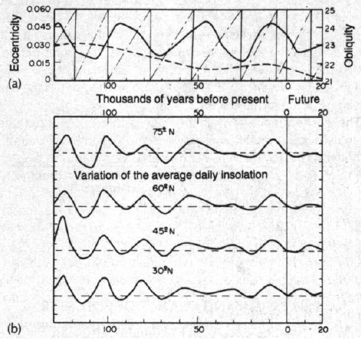
Figure 13
MILANKOVITCH CURVES
AND THE LAST GLACIATION
Milankovitch calculated variations of the orbital and rotational
parameters of the Earth,
and climate, over the
past 130,000 years and the next 20,000.
In (a), the obliquity of the ecliptic (solid line) and the
eccentricity of the orbit (dashed line) are shown.
The dash-dot line
gives the variation of the angle between perihelion and the position
at vernal equinox,
now about 90°, and
going from 0 to 360° in about 20,000 years.
The variation of the average daily insolation from the values of the
year 1950 is shown in (b),
with 1 unit of the
vertical scale corresponding to 25 watts per square meter.
Source: Adapted from A. Berger, 1977, Celestial Mechanics, Vol. 15,
p. 53, and 1978, Quaternary Research, Vol. 9, p. 139.
Reprinted with the
permission of Macmillan Publishing Company,
a Division of
Macmillan, Inc., from Earth and Cosmos by Robert S. Kandel, 1980
The close relationship between the
variations of average daily insolation and the estimated
variation in average temperature during the last 100,000-year-plus
ice age cycle is seen.
The relative smoothness of the future 20,000 years of the cycle led
Milankovitch at one point to forecast that the onset of the next
100,000-year ice age would not occur for another 20,000 years. The
situation is not so simple, however. One sees a similar smoothness
in the insolation curve in the period 20,000 to 50,000 years
before the present, when the ice age cycle was known to be
advancing, in fact, toward the maximum glaciation.
Many other things must be taken into
account, and one cannot use the mathematically derived curves
exactly as a fortune-telling wheel.
One of the interesting features
of the climate cycle is the fact that an advance of glaciation seems
to be self-feeding, because of the increase in the Earth's
surface albedo (the reflectance of incident light) caused by a
covering of bright white ice or snow.
The effect, however, is never direct,
but is modulated by weather patterns - the production of winds,
clouds, ocean currents, and all the many other interrelated factors
that make weather forecasting so difficult and imprecise a science.
Milankovitch's own reflections on the validity of his theory of the
astronomical cycles are worth noting:
"The fluctuations in the radiation
received by the Earth over long periods of time are only one
component of the climate of the past, but they are the most
important one, and, moreover, one which is amenable to precise
investigation." 7
Notes
-
See, for example, Hugh W.
Ellsaesser, 1991. "Setting the 10,000-year Climate Record
Straight," 21st Century, Winter, p. 52; and Dixy Lee Ray,
1990. "Scientific Evidence Vs. Climate Hoaxes: Greenhouse
Earth," 21st Century, Winter, p. 28.
-
H.H. Lamb, 1985. Climatic
History and the Future (Princeton, N.J.: Princeton Univ.
Press), pp. 437-39.
-
Martin Schwarzbach, 1986. Alfred
Wegener: The Father of Continental Drift (Madison, Wis.:
Science Tech, Inc.), p. 76.
-
Schwarzbach, p. 82.
-
Schwarzbach, p. 97.
-
J.D. Hays, J. Imbrie, and N.J.
Shackelton, 1976. "Variations in the Earth's Orbit:
Pacemaker of the Ice Ages," Science, Vol. 194, pp. 1121-32.
-
Schwarzbach, pp. 97-98.
References
-
A. Berger, 1978. "Long-term
variations of caloric insolation resulting from the Earth's
orbital elements," Quaternary Research, Vol. 9, pp. 139-167.
-
H.H. Lamb, 1985. Climatic
History and the Future (Princeton, N.J.: Princeton Univ.
Press).
-
John Imbrie and Katherine Palmer
Imbrie, 1979. Ice Ages: Solving the Mystery (Hillside, N.J.:
Enslow Publishers)
-
Robert S. Kandel, 1980. Earth
and Cosmos (Oxford: Pergamon Press)
-
Kirk A. Maasch, 1992. "Ice Age
Dynamics," Encyclopedia of Earth System Science, Vol. 2, pp.
559-69
-
Martin Schwarzbach, 1986. Alfred
Wegener: The Father of Continental Drift (Madison,
Wisconsin: Science Tech, Inc.). Originally published in 1980
as Alfred Wegener und die Drift der Kontinente
(Stuttgart: Wissenchaftliche Verlagsgesellschaft)
-
Lee A. Smith, 1965. "Paleoenvironmental
Variation Curves and Paleoeustatics," Transactions - Gulf
Coast Association of Geological Societies, Vol. 15, pp.
47-60.
-
Peter Wright, Ralph Hardy, John
Kingston, and John Gribbin, 1982. The Weather Book (Boston:
Little, Brown).
|