|

December 30, 2015
from
TheDailySheeple Website
The storms that devastated the central
United States over the Christmas holidays causing tornadoes and
leaving scores of people dead has shifted to the North Pole where
meteorologists say it is continuing to wreak havoc.
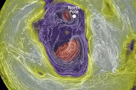
Temperatures at the North Pole, which
are usually about 20° below zero at this time of year, have
spiked as much as 50 degrees in the last 24 hours creating what
scientists call a "bomb cyclogenesis."
The
Washington Post reports:
From Tuesday evening to Wednesday
morning, a mind-boggling pressure drop was recorded in
Iceland: 54 millibars in just 18 hours.
This triples the
criteria for "bomb" cyclogenesis, which meteorologists use to
describe a rapidly intensifying mid-latitude storm. A "bomb"
cyclone is defined as dropping one millibar per hour for 24
hours.
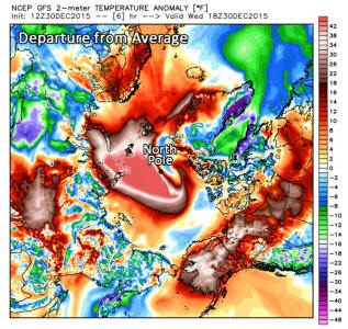
"Consider the average winter
temperature there is around 20 degrees below zero," wrote the
Capital Weather Gang's Jason Samenow on Monday.
A temperature
around the freezing mark signifies a departure from normal of
over 50 degrees, and close to typical mid-summer temperatures in
this region.
In other words,
the area around the North Pole was about
as warm as Chicago on Wednesday, and quite a few degrees warmer
than much of the Midwest.
The major shift in weather in the North
Pole will no doubt lead climate change advocates to cite
global warming as the cause.
But before we make any rash decisions
like
forcing new climate change legislation on the global public or
implementing
Al Gore's
carbon tax credit schemes on businesses who literally stand to
lose trillions of dollars because of the new fees,
let's put
the temperature changes into perspective.
According to NOAA researchers, while the
North Pole storm is outside of the norm, it is not unprecedented:
NOAA's Ocean Prediction Center said
the storm's minimum pressure dropped to 928 millibars around 1am Eastern time, which likely places it in the top
five strongest storms on record in this region.
"According to the center's
records, the all-time strongest storm in this area occurred
on Dec. 15, 1986, and that had a minimum central pressure of
900 millibars," Mashable's Andrew Freedman reported on
Tuesday.
"The second-strongest storm
occurred in January 1993, with a pressure of 916 millibars."
Freak Storm Pushes North Pole...
50°
Above Normal to Melting Point
by Angela Fritz
December 30, 2015
from
WashingtonPost Website
|
Angela Fritz is an
atmospheric scientist and The Post's deputy weather
editor. |
This
storm in the far North Atlantic is the same
storm that caused two tornado outbreaks and
widespread flooding in the United States.
Now,
it's pushing temperatures at the North Pole
well above average. (see
here)
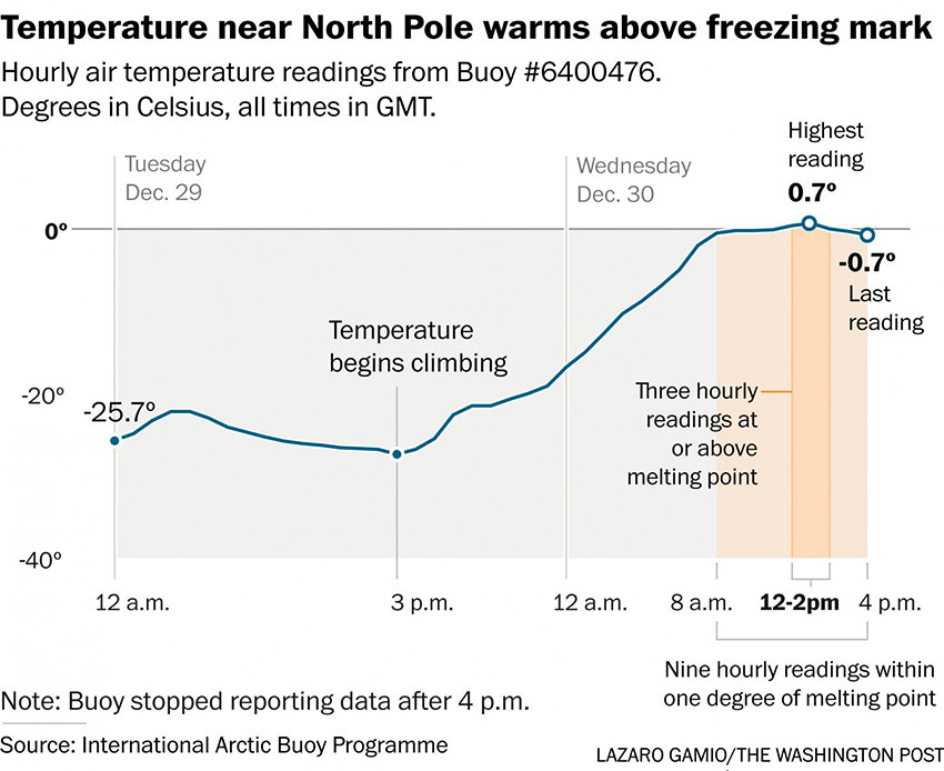
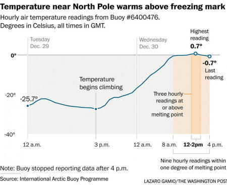
This story has been updated to include buoy measurements that
confirm the North Pole temperature climbed above 32 degrees on
Wednesday.
A powerful winter cyclone - the same storm that led to
two tornado outbreaks in the United
States and
disastrous river flooding - has
driven the North Pole to the freezing point this week, 50 degrees
above average for this time of year.
From Tuesday evening to Wednesday morning, a mind-boggling pressure
drop was recorded in Iceland: 54 millibars in just 18 hours.
This
triples the criteria for "bomb"
cyclogenesis, which meteorologists
use to describe a rapidly intensifying mid-latitude storm. A "bomb"
cyclone is defined as dropping one millibar per hour for 24 hours.
NOAA's Ocean Prediction Center said the storm's minimum pressure
dropped to 928 millibars around 1
am Eastern time, which likely places it in the top five strongest
storms on record in this region.
"According to the center's records, the all-time strongest storm in
this area occurred on Dec. 15, 1986, and that had a minimum central
pressure of 900 millibars," Mashable's Andrew Freedman
reported on Tuesday.
"The second-strongest storm occurred
in January 1993, with a pressure of 916 millibars."
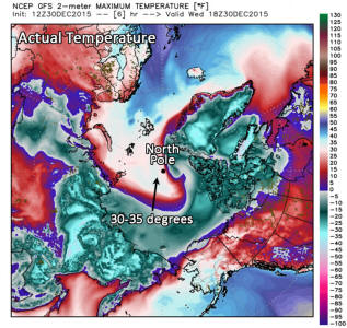 
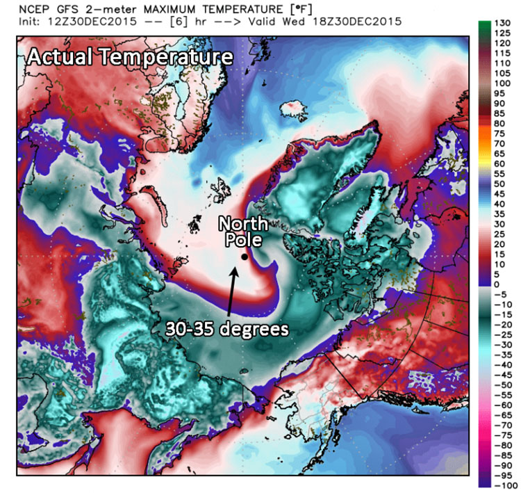
Temperatures in the Arctic Circle
were hovering around
32 degrees on Wednesday morning,
using data from the
GFS model.
(weatherbell.com)
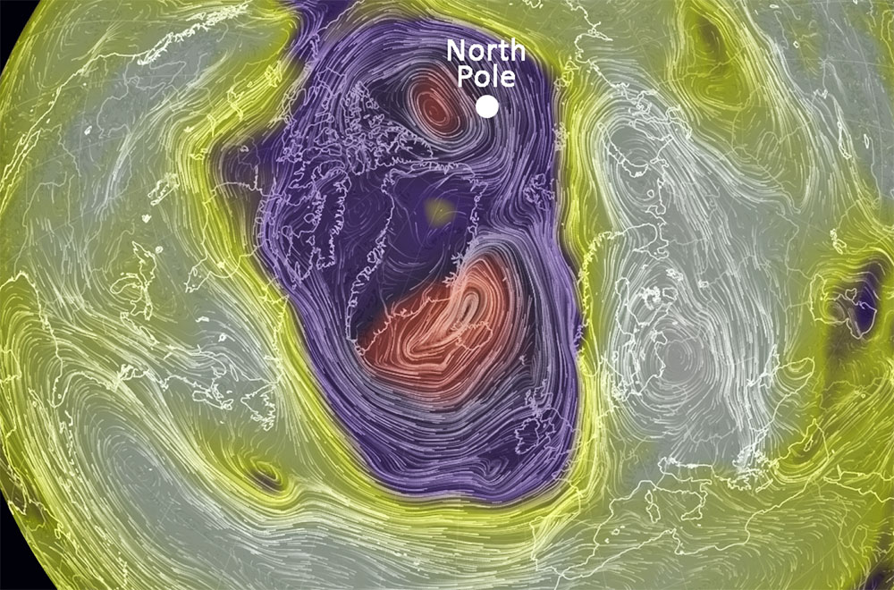
As this storm churns north, it's forcing warm air into the Arctic
Circle.
Over the North Sea, sustained winds from the south are
blasting at 70 mph, and gusting to well above 100 mph, drawing heat
from south to north.
Although there are no permanent weather stations at the North Pole
(or really anywhere in the Arctic Ocean), we can use weather
forecast models, which ingest data from satellites and surrounding
surface observations, to estimate conditions at Earth's most
northern location.
On Wednesday morning, temperatures over a vast area around North
Pole were somewhere between 30 and 35 degrees Fahrenheit, and for
at least a brief moment, surpassed
the 32-degree threshold at exactly 90 degrees North, according to
data from the GFS forecast model.
Data from the International Arctic Buoy Program
confirms that temperatures very
close to the North Pole surpassed the melting point on Wednesday.
A
buoy (WMO ID Buoy 6400476) at a latitude of 87.45 degrees North hit
a high temperature of 0.7 degrees Celsius - or 33 degrees
Fahrenheit.
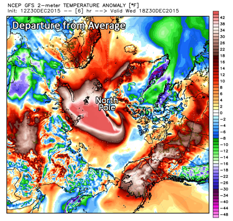
"Consider the average winter
temperature there is around 20 degrees below zero,"
wrote the Capital Weather Gang's
Jason Samenow on Monday.
A temperature around the freezing mark
signifies a departure from normal of over 50 degrees, and
close to typical mid-summer
temperatures in this region.
In other words, the area around the North Pole was about as warm as
Chicago on Wednesday, and quite a few degrees warmer than much of
the Midwest.
How El Niño will affect weather conditions
this year
According to the World Meteorological Organization, the El Niño of
2015-2016 is shaping up to be one of the strongest in this past
century. Here are the types of weather we can expect around the
world due to this year's El Niño.
(World Meteorological
Organization/YouTube)
Meanwhile in habitable areas around the North Atlantic, winds are
howling and waves are rocking the coastline.
In Britain, a week of
excessive rainfall has pushed rivers and streams well beyond their
banks, stranding vehicles and buckling bridges.
In a
blog post on Monday, the U.K. Met office said that December has
been a record-breaking month for rainfall in parts of the United
Kingdom.
A Christmas weekend storm brought up to 8 inches of
addition rainfall on saturated soil.
The Met Office listed just a
small portion of the December records that were set this weekend, in
some cases blowing away the previous December records by 10 inches.
Massive waves and floods hit the U.K.
Ireland, Scotland and England are getting slammed by Storm Frank as
it barrels into Europe. Social media users captured what the heavy
rain and floods look like from windows, cars and backyards. (Jenny
Starrs/The Washington Post)
|