|
from OurHollowEarth Website
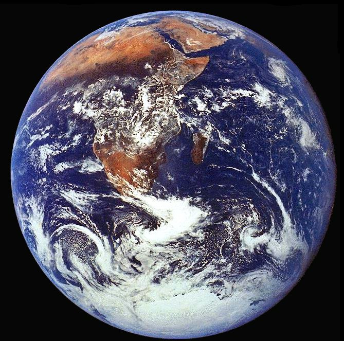
It is assumed that the polar openings were formed when the earth was created because centrifugal force would throw matter away from the axis of rotation leaving a hollow in the earth and polar openings at the polar axis.
Additionally, the earth's foundational
premise is a spiritual hollow globe upon which space dust and rocks
accumulated.
The Pyramid of Giza, which this author believes was built before the Flood of Noah, has a construction orientation aligned with the original axis of rotation of the earth. When the passageway into the pyramid was first discovered it was soon realized that it had originally pointed towards what was then the North Polar Star. That star is not Polaris, the North Star of today.
It has shifted several degrees, indicating that the earth's axis may
have been tilted since the construction of that pyramid.
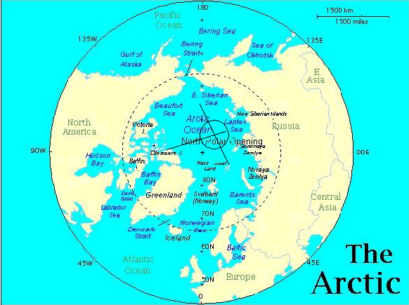
The United States has a permanent station located at the South Pole on the Antarctic continent. And the North Pole has been crossed several times by polar explorers beginning with the Amundsen dirigible expedition in 1926 which flew from Spitsbergen to Alaska over the Pole.
Wally Herbert took his dog sleds over the pole from Alaska to Spitsbergen going the opposite direction. Also the Soviet Ice Breaker, The Yamal, takes tourists to the pole each year north of Franz Josef Land.
This
service is contracted by
ADVENTURE ASSOCIATES Pty Ltd, 197 Oxford
Street Mall, Bondi Junction, Sydney NSW 2022, Australia, Postal
Address: PO Box 612 Bondi Junction NSW 1355 Australia, Ph: (+61 2)
9389 7466 Fax: (+61 2) 9369 1853, for a 19-day trip for
$15,950-$18,950 trip to the North Pole with additional cost for a
flight from your hometown to Murmansk, Russia.
Two other, more expensive, seven-night
trips are offered by High Arctic International (819-252-3616) for
$8,650 per person is based also in Resolute Bay, and Arctic Odysseys
(206-455-1960) $11,000 out of Medina, Washington. These trips depart
each April and include visits to both the geographic and magnetic
North Poles, dog sledding along the northwestern coast of Greenland,
and overnight stops on Ellesmere Island at the Eureka Weather
Station and Grise Fjord. (December 1993, Outside Magazine, p. 50)
The warm north wind in winter, the warm winter foehn storms that come from the north, the drift wood with green
leaves, the migration of birds and animals, the solar wind emanating
from the polar region to light up the auroras and then trapped in
the Van Allen Radiation Belts are a few of the evidences for the
existence of polar openings.
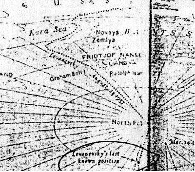
There is the case of the Lost Soviet flyers who flew north from Russia and were lost somewhere between the Kara Sea on the Russian side of the pole and Alaska, as reported by Vilhajalmur Stefansson in his book, UNSOLVED MYSTERIES OF THE ARCTIC.
Then there is the Olaf Jansen's story in which he described their 1829 trip through the North Polar Opening in their small boat sailing between leads in the ice on a course heading North East of Franz Josef Land.
Recently, in Jan Lamprecht's book, Hollow Planets, he describes the sighting by Peary and Cook and other arctic explorers such as Col. Green of the U.S. Navy of a mirage of land North West of Ellesmere Island in Northern Canada. Jan also writes of the Russian sighting of Sannikov land north of Russia.
The Amundsen dirigible transpolar flight of 1926 from Spitsbergen to the Pole and from the Pole to about 100 miles west of Point Barrow, Alaska would indicate the north polar opening would need to be located to one side of their line of flight.
The British
arctic explorer, Wally Herbert, also took this same path only from
the other direction from Alaska to Spitsbergen.
NORAD image of the north polar showing polar orbiting satellite paths
My friend Ivars recently sent me an image that a security guard snapped with his cell phone camera off a NORAD computer screen showing the flight paths of all the polar orbiting satellites.
The interesting part of this image is that on the Russian side of the pole, there are no orbiting satellites between about 115° E Lon and 155° E Lon.
You can see North Land, Russia jutting out
into the Arctic Ocean opposite the geographic pole. This is the
strongest evidence I have seen that the polar opening is located on
the Russian side of the pole.
This most likely happened because they were attempting to put them in orbit over the polar opening without realizing it. Subsequent polar orbiting satellites, therefore, have all been placed in orbit such that they do not pass over the the polar opening.
With no matter over the polar opening to exert a gravitation acceleration towards the center of the planet, satellites put in orbit over the polar opening would be lost into space if above a certain distance, or if too close to the surface, would follow the curvature of the opening into the earth and crash inside the earth.
When we go to the inside
of the earth in our upcoming expedition, we may find that those
first lost satellites actually crashed on the inner surface of the
earth's shell.
Japanese Weather Satellite arctic ice photo
In 2008, my cousin found some Japanese Weather Satellite imagery where he claimed he could see the north polar opening as a permanent oval feature throughout all the stills of the video.
After analyzing it carefully, I discovered that this oval is located exactly at the North Geographic Pole.
In this still image from the video (see above), M'Clure Strait can be seen just north of Banks Island on the northern coast of Canada. To the left top of the oval area in question, can be seen North Land, Russia jutting out into the Arctic Ocean. The video this image was distilled from can be viewed on his website.
The problem I see with this oval being the polar opening, is that it
is located exactly at the North Geographic Pole.
When asked why satellite imagery shows a "hole" at the geographic pole, the response was that the satellite imagery doesn't quite reach up to the pole and so leaves a "hole" in the imagery.
So these "holes" in the satellite imagery do not depict an actual hole in the earth.
The reason polar orbiting satellites cannot take imagery clear up to the pole is revealed in the NORAD polar satellite paths image my friend Ivars sent me. The reason is - NO polar orbiting satellite can pass over the pole because the polar opening is too close to it. Polar orbiting satellites cannot pass over the polar opening because it has no matter to exert a gravitational acceleration on the satellite to keep it in orbit if it went over the opening.
This is a key to
locating the polar opening.
The U.S. nuclear submarine, the
Nautilus, crossed the pole from Alaska in 1958. Wally Herbert from
Britain crossed the pole from Alaska to Spitsbergen with his dog
sleds in 1969.
We visited Billie in Pahrump, Nevada in November, and I have been writing a biography that you can read here. Billie has had a very interesting life, much of it having to do with Our Hollow Earth. After joining the military, Billie was assigned to Area 51 in Nevada, USA.
While at Area 51, Billie was assigned an office in the Administration and Archives, level 6.
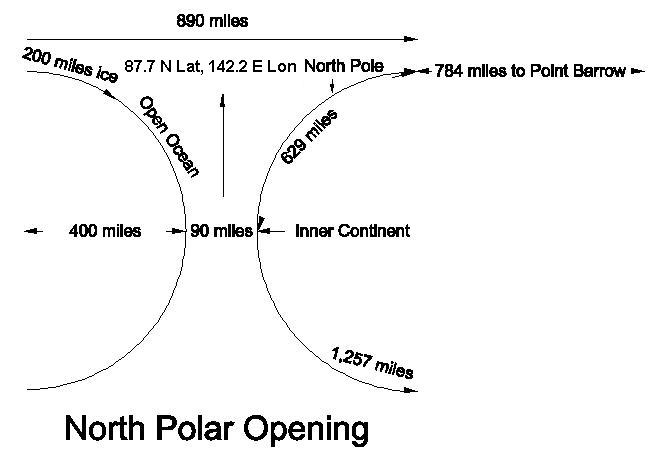
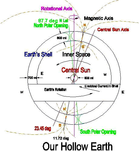
Billie distinctly remembers reading a 35 page document on the discoveries of Our Hollow Earth by Admiral Richard E. Byrd, and before leaving the military recorded the exact coordinates of the north polar opening on a piece of paper Billie managed to take upon being discharged from the military. For the North Polar Opening, those coordinates are 87.7° N Lat, 142.2° E Lon.
I have determined
that these coordinates give the most correct estimate of the
location of the North Polar Opening and supported by all the
evidence I have been able to gather.
That would place the span from the center of the polar opening to the periphery where the earth begins to curve into the opening at 890 miles. The North Geographic pole would be on the top rim of the perimeter, somewhat inside where the opening begins to dip into the polar hole.
This would explain why Wally Herbert had some difficulty in pinpointing the exact geographic pole on his dog sled trek across the Arctic in 1969.
Rodney M. Cluff
1/29/2009 In this drawing of the North Polar Opening, the thickness of the earth's shell is assumed to be 800 miles.
If the earth's shell were any larger, say a thousand or 2,000 miles thick, the polar opening would be too big to be hidden in the Arctic Ocean. So the 800 mile estimate of the earth's shell thickness is a reasonable estimate. It is the estimate of the earth's shell thickness given by the Inner Earth Guide in Etidorhpa and confirmed by Col. Woodard.
The
beginning of the curvature into the opening begins at 890 miles
diameter. At the center of the polar opening, I am estimating the
diameter to be 90 miles.
The
direction from Point Barrow is a bearing of 2.3° to the left
of the geographic north pole. The direction to the North Pole can be
determined at midnight during the spring and summer when the sun can
be seen directly across the pole from Point Barrow.
This estimated location would place the opening on the Russian side
of Amundsen's line of flight from the Pole to Alaska, and yet also
be in the line of sight of the direction that Admiral Peary sighted
the mirage of Crocker land from the west coast of Ellesmere Island
in Northern Canada.
Indicative that the curve into the opening has already begun near the pole is Amundsen's navigator error upon reaching Alaska.
They
had assumed a straight line of flight from Spitsbergen to the Pole
and from the Pole to Point Barrow, Alaska, but upon arriving in
Alaska were surprised that they were around a 100 miles too far west
of Point Barrow, closer towards the Bering Sea that they didn't even
see Point Barrow. This may indicate that near the pole they had
actually dipped somewhat down into the polar opening causing their
straight line of flight to be skewed to the right somewhat.
He
had to retrace his path towards Spitsbergen back to the pole after
having supposedly crossed the Pole in order to find it, and even
then he had difficulty pin pointing the location of the pole because
the sun height would vary above the horizon throughout the day,
which indicates he was actually some distance inside the polar
opening as he was attempting to pin point the location of north
pole.
The island they found on their third day's sailing northeast of Franz Josef Land is not on our maps today.
They found a large accumulation of drift-wood on the northern shore of that island, trunks of coniferous trees two feet in diameter and forty feet long. This encouraged them to continue north.
Again, several days further on, on page 84, Olaf reported,
If this can be taken
as any indication of the direction they were sailing, the north
polar opening would seem to be located northeast of Franz Josef
Land, in the same area that the Soviet flyers were lost, as
described in Vilhajalmur Stefansson's book,
UNSOLVED MYSTERIES OF
THE ARCTIC, and in the same direction that Admiral Peary and Cook
saw the mirage of Crocker land from the west coast of Ellesmere
Island.
Of all Arctic explorers we have
record of, Nansen was the one that got closest to the North Polar
Opening without entering and discovering it. Some of the
observations of Nansen that support a polar opening location north
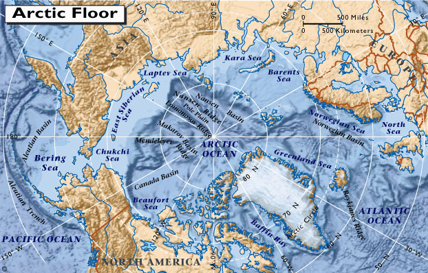
of the New Siberian Islands are as follows.
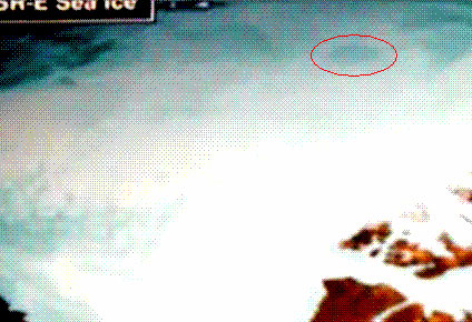
An area north of the New Siberian Islands shows no ice
First, Nansen discovered a substantial stretch of open ocean north of the New Siberian Islands. In contrast, in his passage north of Norway and Russia to the New Siberian Islands, he had to stay close to the coast to get past the ice.
And yet, north of the New Siberian Islands, in September of 1893 on their way north, they didn't find ice until 79° N. Latitude.
Only after 7 days sailing north
over rolling open ocean did they reach the pack ice north of the New
Siberian Islands. Curiously, images gleaned from satellite imagery
on the Living Earth website shows a permanent area north of the New
Siberian Islands that has no ice. This could be an indication that
the polar opening is located on the Russian side of the pole.
They found rock
and large quantities of mud and driftwood on some of the icebergs
that indicated to Nansen that much of the Arctic ice originates in
some river, perhaps further to the north than they were then located
- in some uncharted land.
Curiously, Nansen
discovered that ocean water temperatures were also warmer the
further down he measured it beneath the ice, as also the air
temperature above the ice when measured from the ship's crows nest
was discovered to be warmer than next to the ice.
But there is a possibility that it could have been a mirage of the inner sun.
On page 162, Nansen recorded,
He remarked that it had a hazy, smoky-red color,
similar to the description of the inner sun given by Olaf Jansen,
whose father also at first thought it was a mirage, when they first
caught sight of it in their 1829 journey to the inner world through
the North Polar Opening northeast of Franz Josef Land.
Then volcanic dust fell on the Fram and settled everywhere causing discomfort and irritation.
Nansen wrote in his ship's journal,
There must have been
volcanic eruption on the inner continent near the Polar Opening at
that time because there was none on the outer world. The dust must
have blown out of the Polar Opening onto the ice and upon Nansen's
ship, the Fram.
The New Siberian islands even today are covered with bones and remains of mammoths and other inner earth animals that Olaf Jansen claims fell into ice crevasses of inner earth rivers that empty into the Arctic Polar Opening where they froze and later were carried out to sea and eventually ended up deposited on northern Arctic shores. Remains of woolly rhino, steppe lions, giant deer, mammoth, foxes and a hardy breed horse that scientists claim are prehistoric are preserved in the Arctic ice.
Recently these scientists have been attempting to find some of these exotic animal remains that are frozen and preserved in Arctic ice.
They want to take samples of the
frozen flesh and use it to clone these exotic animals to start a
sort of Jurassic Park. Little do they know that a Jurassic Park
already exists located inside Our Hollow Earth, and can be reached
through the North Polar Opening, north of the New Siberian Islands,
from whence all the frozen exotic carcasses come from.
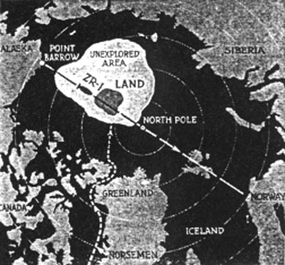
MacMillan had turned back after journeying 120 miles out over the ice pack because the mirage of Crocker land continued to appear ever farther northward no matter how far they traveled towards it.
Later, Lt. Green published an article in Popular Science Monthly, in the December 1923 issue, that he was still convinced that Crocker land still existed and had even convinced the Navy to build a dirigible named the ZR-1 that was going to attempt an over flight of that land.
Here is Lt. Green's
Arctic map showing his estimated location of that unknown land that
MacMillan and his Eskimos thought was just a mirage.
In warmer climates of the world, a mirage mostly looks like water on the horizon because it is reflecting the blue sky.
But in the Arctic, a mirage is caused by warm moist air that comes up out of the Polar Opening from the Inner World. This layer of warmer air above the colder air next to the ice causes mirages or reflections of the ground or ice on the ocean, and not the sky, as in the warmer climates of the world.
In the warmer climates of the world the temperature of the air becomes colder with height above the ground. Just the opposite is the case in the Arctic and Antarctic. Warm, moist air emanating from the earth's hollow interior through the polar openings rises above the ice and serves as a boundary of air that reflects objects on the ground.
Jan Lamprecht, in his book, Hollow Planets, gives convincing evidence that the mirage of Peary's Crocker land and Cook's Bradley land could easily have been a double inverted image of land within the North Polar Opening located somewhere northwest of Ellesmere Island within the area Lt. Green termed on his map the "Unexplored Area."
Notice that my estimated
location for the North Polar Opening is located within Green's
unexplored area. The land that Green thought must be there, is,
however, actually located within the Polar Opening.
The last ship known to have returned from their Arctic colonies to Norway was in 1410.
When the Dark Ages had past and Greenland was once again rediscovered with Hans Egede establishing the first modern settlement there in 1721, all that could be found of the original Viking settlers was their ruins and some of their animals.
Even the Arctic author Vilhajalmur Stefansson in his book, UNSOLVED MYSTERIES OF THE ARCTIC, concluded that the disappearance of the lost Viking colony in Greenland was a mystery.
The Viking colonists had apparently migrated further and further
north where they found wild life and fish more plentiful, until they
disappeared.
The Viking explorer parties had come back and had told the rest of their Greenland colony of their wonderful discovery. All promptly packed their bags, and singing songs, departed suddenly northward and never returned.
The Eskimo tradition is that over the ice towards the northwest, in the direction Admiral Peary sighted Crocker land and Cook sighted Bradley land, is a ...
Lt. Green shows that trail on his map.
It is located on the west side of Greenland, and goes up around Ellesmere Island, and out over the pack ice in a northwest direction towards the land he claimed exists in the "Unexplored Area."
That is the
same area I have estimated the North Polar Opening is located.
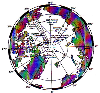
direction mirages of land seen in arctic
Jan Lamprecht has a map on page 193 of his book, HOLLOW PLANETS, showing the location and directions of sightings of mirages of anomalous lands in the arctic, which are not found on any current day maps.
Taking these sightings and triangulating them towards the points towards which they were observed and from the locations in which they were sighted, gives us another indication where the center of the North Polar Opening most likely is located. North from the New Siberian Islands the Russians sighted the mirage of Sannikov land. Northwest of Ellesmere Island was the sighting of Crocker land by Admiral Peary, Lt. Green and MacMillan.
Bradley land was also sighted in that same general direction by Polar explorer Dr. Cook on his way to discover the pole. From Alaska, from Harrison Bay, was sighted land also towards the north west by Captain Keenan.
If we draw a line from each of
these locations towards their respective directions in which
anomalous land was sighted, we arrive at the approximate location of
the North Polar Opening.
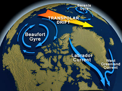
Nansen embedded his ship in the ice and drifted across the Arctic in the ice flows to the east side of Greenland. This arctic current called the Transpolar Drift acts like a swift running stream of water in a ditch. In fact, the underwater canyons in this area follow the same direction as the Transpolar Drift.
On this map (below) you can see three ocean bottom ridges crossing the Arctic ocean in the same direction as the Transpolar Drift.
This current carries ice out of the polar opening across the Arctic Ocean to the Greenland side of the pole causing eddy currents on either side of the Transpolar Drift. The eddy current on the Canadian side of the Transpolar Drift produces the Beaufort Gyre north of Canada and rotates clockwise.
This eddy current causes the ice to pile up onto the shores of northern Canada to the greatest depths of anywhere in the Arctic ocean.
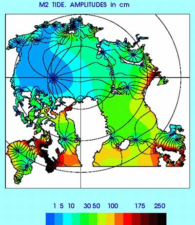
The thinnest ice is located where the ice comes from - in an area north of the New Siberian Islands - another indication where the polar opening is located. Then on the Russian/European side of the Transpolar Drift in the Barents Sea, the eddy current rotates counter-clockwise. Because the eddy current is stronger on the Canadian side, the whirlpool effect causes the lowest tide height in the Arctic ocean in the center of the Beaufort Gyre.
You can see below a map of this low tide location:
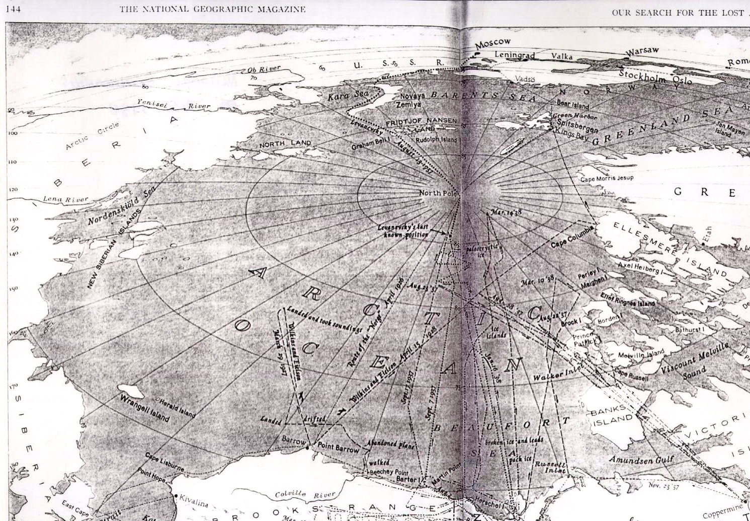
I did not accept this argument because that whole area on the Canadian side of the pole was crisscrossed by the search flights looking for the missing Soviet Flyers as shown in the National Geographic map published in Vilhajalmur Stefansson's book, UNSOLVED MYSTERIES OF THE ARCTIC.
Yet, the Americans didn't extend their search to the Russian side of the pole in the area I had estimated the polar opening to be located and the search flights from the Russians just went up to their sextant determined pole and not beyond, which if they had continued on would have gotten lost also.
Notice that the Soviet Flyers made a course correction after supposedly reaching the pole. Most likely, then, the Lost Soviet Flyers never actually reached the North Geographic Pole.
Instead,
they reached a point on the lip of the polar opening that gave the
sextant reading showing the correct angle between the horizon and
the sun that would have indicated they were at the pole, but since
they were instead on the lip of the polar opening and thinking they
were at the pole, they then turned to the right towards Alaska,
which course actually took them directly through the neck of the
polar opening and into the interior of the earth.
It
is a jet stream of air that follows the same path of the Transpolar
Drift across the north pole. Studying this, I then realized that
this jet stream of moist air is coming up out of the polar opening
north of the New Siberian Islands, flows across the arctic and drops
it's moist air onto the Greenland ice cap. Over the years, this has
resulted in an accumulation of ice on the Greenland continent to the
awesome depth of nearly two miles!
If it had, those places would today be covered by an ice cap 2 miles thick just like Greenland is today!
If we follow that jet stream of moist air from Greenland back across the Arctic, we find that it points to the location of the polar opening - on the Russian side of the pole!
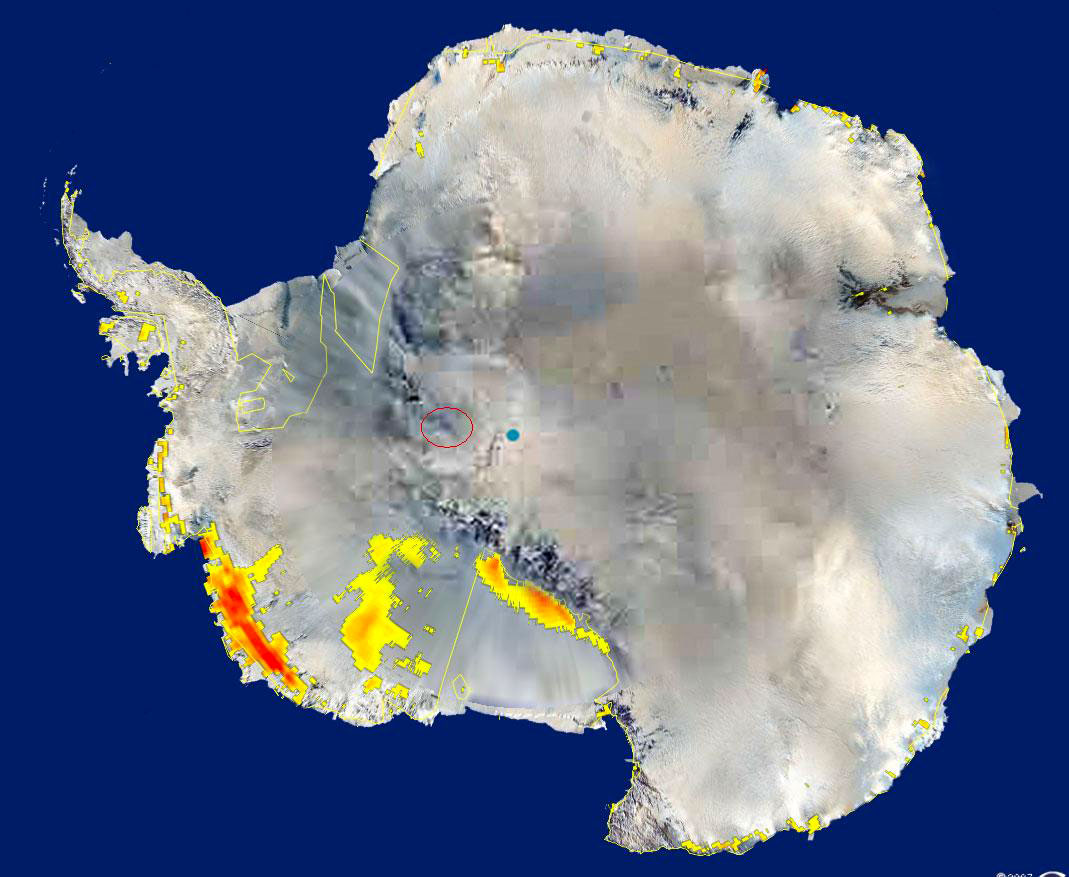
The same thing is happening in Antarctica. I estimate the South Polar Opening to be located at the exact opposite of the globe from the North Polar Opening, which would put the South Polar Opening at 88° S Lat, 38° W Lon.
Warm, moist air coming up out of the south polar opening blows
out over east Antarctica and has created an ice cap there to a depth
of over 2 miles!
Eddy currents on each side of the Transpolar Drift flowing out of that area cause the Beaufort Gyre to rotate clockwise and the gyre in the Barents Sea to rotate counter clockwise on either side of this swift current of water coming up out of the polar opening.
Perhaps the
Transpolar jet stream and ice flows originate from the valley of the
River Hiddekel that empties into the Arctic Ocean within the polar
opening from the Inner Continent.
South Polar Opening
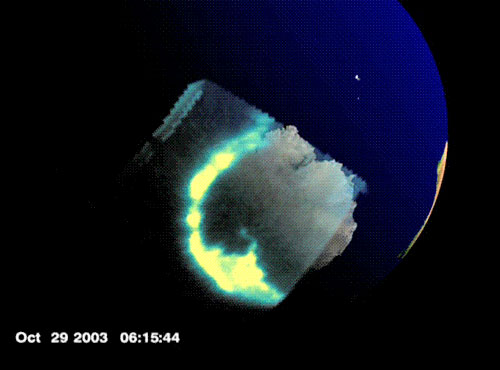
It shows the auroral radiation coming from an oval location on the western portion of Antarctic where I estimate the south polar opening is located.
This location of the South Polar opening is located in the
same area that looks like an elliptical area in the Apollo 17 image
(above).
NASA Auroral Australis photo The oval location from which the auroral radiation is emanating from can be seen better by viewing the auroral NASA movie that this still was taken from.
You can view the movie below.
Another NASA auroral image (below) also shows the source of the auroral radiation coming up from the western part of Antarctica.
The location for the South Polar Opening is located on the earth opposite the North Polar Opening.
The North Polar Opening centered on the coordinates of 142.2° E Longitude, 87.7° N Latitude would put the location of the South Polar Opening 180° opposite the location of the North Polar Opening at 37.8° W Longitude and at 87.7° S Latitude.
|