|

17 Septiembre 2008
del Sitio Web
TrinityEyes
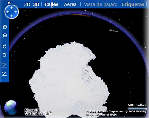
Foto desde el ordenador de Sat7.
Así pude comprobar que la Nasa pone parches a la fotografía de la
Antártica.
Te invito a hacer la prueba tal y como enseña Tito
Martínez:
¿Sabía usted que la NASA falsifica las fotografías de la tierra y
del resto de los planetas del sistema solar? Y esto lo hace para
ocultar que
todos ellos son huecos, con aperturas polares, y con un
sol interno.
Esto lo voy a demostrar con el siguiente reportaje
gráfico.
-
Para empezar, entre usted en este sitio Web:
http://maps.live.com
y luego haga clic arriba a la izquierda, donde pone 3D, para
descargar la versión en tres dimensiones de esa cartografía de la
NASA.
-
Abajo a la derecha verá que dicha cartografía corresponde a la
NASA, es decir, no es una cartografía cualquiera, sino que
corresponde a fotografías de satélite tomadas por la NASA desde el
espacio.
-
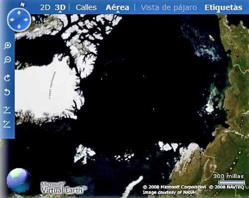
Ahora con el ratón mueva el mapa, y diríjase hacia la
Antártica,
y poco a poco aumente la imagen con la rueda del ratón. Y te saldrá
la fotografía que me salió a mi mismo (Sat7) puesta al principio del
post. Vas a comprobar por tí mismo el gran parche blanco que han
colocado sobre la fotografía de la entrada al interior de la Tierra
en el polo sur.
Y ahora movámonos y trasladémonos al “Polo Norte” y observe bien la
foto.
¿Donde se encuentra el casquete polar? ¡En ninguna parte!.
En
la foto aparecen los hielos de Groenlandia, el norte de Canadá y el
norte de Siberia, pero el casquete de hielo del “Polo Norte” no
aparece por ninguna parte, ¿por qué?, ¡por la sencilla razón de que
no existe!.
La NASA ha falsificado la fotografía, ocultando la
Apertura Polar Norte, de la misma manera que han ocultado la
Apertura Polar Sur.
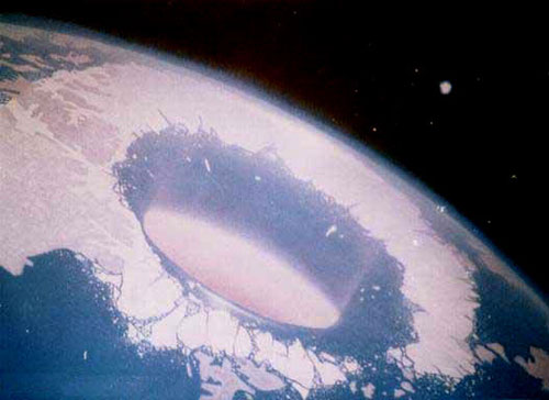
Lo siguiente que vas a hacer es mover el ratón en dirección a
Siberia mas o menos y vas a comprobar que ya no da mas la foto
satelital, pues bien, ahí vas a darle a la lupa acercando y alejando
y con sorpresa vas a ver que hay un círculo de puntos blancos en la
zona donde debería de verse la entrada a la Tierra Hueca!
Esta es la foto desde mi ordenador:
¿Porqué hay puntos blancos dibujando un circulo casi perfecto en las
aguas del polo norte?
Porque ésa es la entrada al interior de la
Tierra por el polo norte y sale mucha luz de ella, pero no lo
taparon bien, seguramente en unos días (después que ellos lean esto,
corregirán su chapuza. Pero mientras tanto, nosotros al menos
sabremos de sus mañas ocultistas).
Esta es la imagen real de la apertura del polo norte:
La NASA no solo falsifica las fotografías de la Tierra tomadas por
los satélites artificiales, para ocultar las dos aperturas polares,
sino que también falsifica las fotografías de los planetas del
sistema solar, para ocultar que todos ellos también son huecos, con
aperturas polares, y con un sol interno.
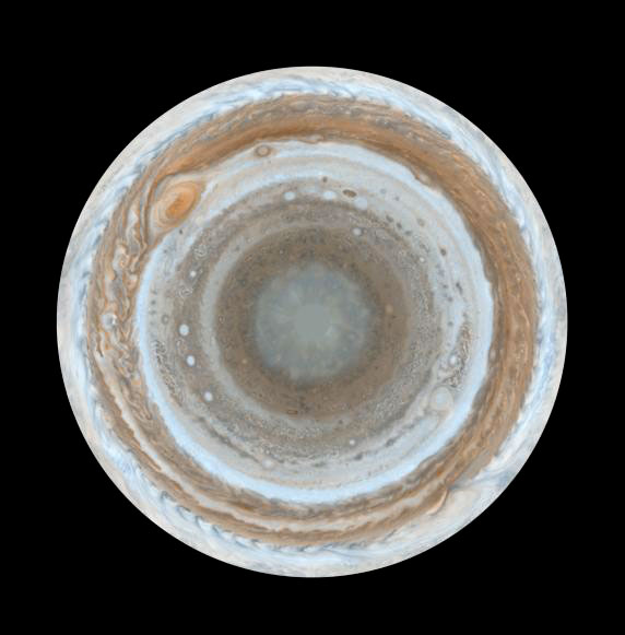
La siguiente foto la he
tomado de
corresponde al planeta Júpiter y fue tomada por la nave espacial
Cassini de la NASA en el año 2000.
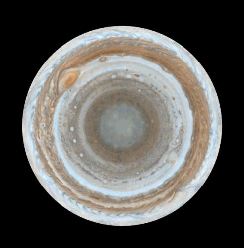
http://photojournal.jpl.nasa.gov/catalog/PIA07784
La foto corresponde al polo sur
de Júpiter. La nave espacial se acercó a Júpiter durante su vuelo
alrededor del planeta. La nave Cassini estaba en camino hacia
Saturno. La foto es la más completa y detallada que existe de
Júpiter.
Observad bien la imagen de Júpiter, la cual he ido ampliando en
cuatro secuencias.
Fijaos bien en el centro de la imagen, si miráis
bien la foto más ampliada veréis que ¡¡ el sol interno de Júpiter ha
sido tapado con un parche redondo de color gris!!. sin embargo, los
rayos solares de dicho sol interno de Júpiter se pueden apreciar
perfectamente en los bordes de dicho parche (es lo mismo que
hicieron con la apertura del polo norte de la tierra).
Con todo esto, ya solo nos queda preguntarnos: ¿Porqué nos lo
ocultan?
LA TIERRA ES HUECA
por Mizar-Petrus
Abril 1, 2009
del Sitio Web
Vimeo
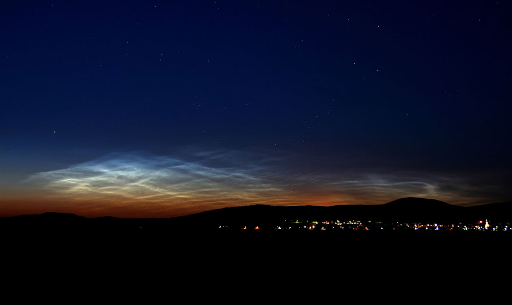
Puedes ver aquí abajo, una fotografía de nubes iluminadas por el sol
interior de la tierra, claro que los de la NASA dicen que no tienen
explicación:
NASA Satellite Captures First View of 'Night-Shining Clouds'
by Cynthia O'Carroll
June 28, 2007
from
NASA Website
traduccion Google
A NASA satellite has captured the first occurrence this summer
of mysterious shiny polar clouds that form 50 miles above
Earth’s surface.
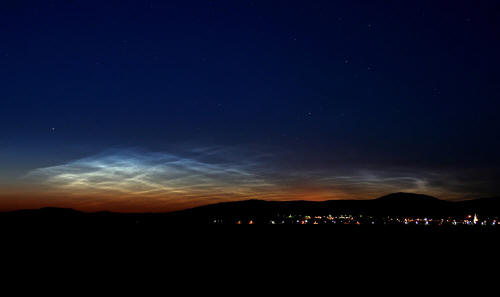
This image shows one of the first ground sightings
of noctilucent clouds in the 2007 season.
Credit: Veres Viktor
of Budapest, Hungary taken on June 15, 2007.
The first observations of these "night-shining" clouds by a
satellite named "AIM"
which means Aeronomy of Ice in the
Mesosphere, occurred above 70 degrees north latitude on May 25.
People on the ground began seeing the clouds on June 6 over
Northern Europe. AIM is the first satellite mission dedicated to
the study of these unusual clouds.
These mystifying clouds are called Polar Mesospheric Clouds, or PMCs, when they are viewed from space and referred to as "night-shining"
clouds or Noctilucent Clouds, when viewed by observers on Earth.
The clouds form in an upper layer of the Earth’s atmosphere
called the mesosphere during the Northern Hemisphere’s summer
season which began in mid-May and extends through the end of
August and are being seen by AIM’s instruments more frequently
as the season progresses.
They are also seen in the high
latitudes during the summer months in the Southern Hemisphere.
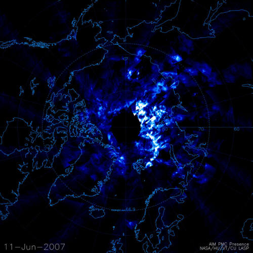
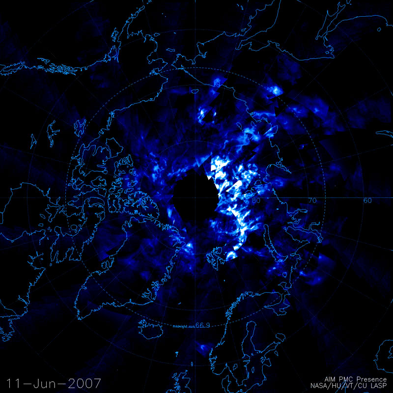
On June 11, 2007 the cameras on the AIM satellite
returned some of the first data documenting noctilucent clouds
over the Arctic regions of Europe and North America. This new
data reveals the global extent and structure of these mysterious
clouds, to a degree that was previously unattainable.
White and
light blue represent noctilucent cloud structures. Black
indicates areas where no data is available.
Credit: Cloud
Imaging and Particle Size Experiment data processing team at the
University of Colorado Laboratory for Atmospheric and Space
Physics
Very little is known about how these clouds form over the poles,
why they are being seen more frequently and at lower latitudes
than ever before, or why they have been growing brighter.
AIM
will observe two complete cloud seasons over both poles,
documenting an entire life cycle of the shiny clouds for the
first time.
"It is clear that these clouds are changing, a sign that a part
of our atmosphere is changing and we do not understand how, why
or what it means," stated AIM principal investigator James
Russell III of Hampton University, Hampton, Va.
"These
observations suggest a connection with global change in the
lower atmosphere and could represent an early warning that our
Earth environment is being changed."
AIM is providing scientists with information about how many of
these clouds there are around the world and how different they
are including the sizes and shapes of the tiny particles that
make them up.
Scientists believe that the shining clouds form at
high latitudes early in the season and then move to lower
latitudes as time progresses. The AIM science team is studying
this new data to understand why these clouds form and vary, and
if they may be related to global change.
Once the summer season ends in the Northern Hemisphere around
mid- to late August, the Southern Hemisphere spring season
starts about three months later in the period around mid- to
late November. AIM will then be watching for shining clouds in
the Southern Hemisphere from November through mid-March when
that season ends.
AIM is managed at Goddard Space Flight Center, Greenbelt, Md
and the AIM Project Data Center is located at Hampton
University.
|