|

from
HollowOrbs Website
The following is a sped-up NASA film
clip of the aurora australis. One thing that is unique about this
clip is that it shows the aurora emanating from an orifice in the
continent of Antarctica. This observation flies in the face of the
accepted theory that the aurora is directly caused by the solar
winds. We suggest that radiations from the Sun, including the solar
winds, well up within the hollow portion of the Earth and are
expelled at times, causing the auroral display at a certain altitude
of friction.
Watch NASA Clip:
Perhaps the reader would like to familiarize him or herself with
this concept of an upshooting aurora. Testimony from the Arctic
explorers of yesteryear can help:
Upwards Aurora
Below, the reader will find still shots extracted from the clip
which show the point of origin of the aurora. Please note that our
humble efforts have not produced the same quality of resolution as
the NASA clip. At this point we can focus on another unique
characteristic of this NASA clip - its satellite imagery clearly
shows the location of the Southern orifice. A made-to-order clip
could not serve our purposes better.
At this point it would be helpful to refer the reader to another
NASA image and its interpretation, which can be found on our
Radarsat page. Our comments on the location of the Southern orifice
should be understood in conjunction with the far below report (Antartic
Opening).
What the reader should keep in mind as he or she peruses the images
below is that the opening is not a matter of flat surface where a
hole opens up such that the opening is formed by a right angle drop.
The area around the opening, in other words- that whole side of the
Antarctic, is a basin or depression which funnels down into the
orifice in a way similar to an hourglass because, of course, the
orifice flairs open on the other side. The problem is that this
depression, which is 3-D, is being represented on a two dimensional
surface, a flat map, such that the opening gives the impression of a
straight-down hole being drilled on a flat surface. Again, it is not
exactly like that.
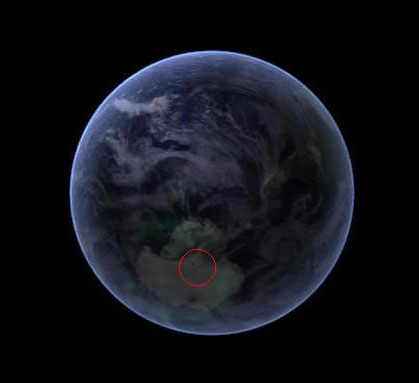
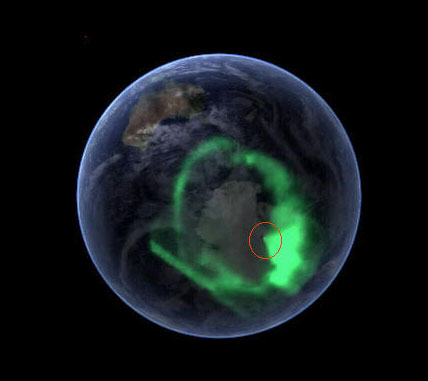
In the first image below, a dark point
can be seen within the pink circle. Basically, it sits between the
American McMurdo Base, The South Pole, the Russian Vostok, and sits
within a thin strip denominated "unclaimed territory" on
Antarctic
maps.
At this point, the image below shows
that the aurora is spouting out from the opening.
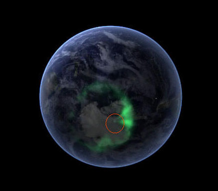
Again, the point of origin for the out-flowing aurora is seen.
Towards the end, the outflow is more intense, and it can be seen
that the solar winds are brushing the out-flowing aurora to one
side.
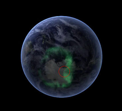
Ditto for this image.
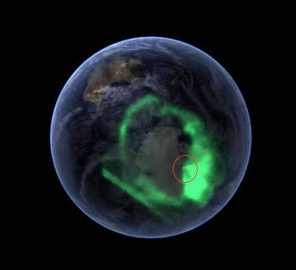
Finally, the opening can be seen with the diffuse aurora around it.
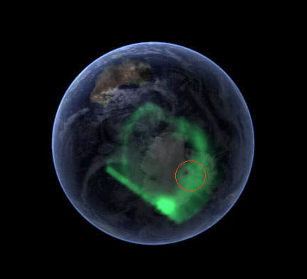
Thus, these NASA images demonstrate that
the aurorae originate from within the Earth, that they are expressed
through the polar orifices, and the images pinpoint the location of
the Southern polar orifice, for all time, better than any of our
efforts could do.
These images from NASA archives were brought to our attention by
Jones Mc Nibbley.
Antartic Opening?
from
HollowOrbs Website
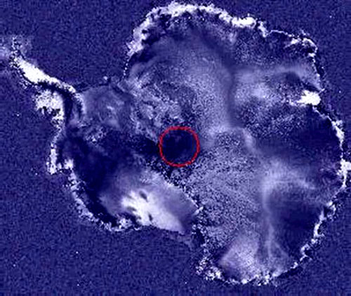
"If you blow up the RadarSat image
of the area I have identified as the south polar opening, you
can see fog coming up out of the opening on the right side of
the dark area. Now why would fog be coming up out of this area
if it's not the opening? I think this fog may be our first clue
that this is the area we have been looking for.
Also, notice that towards the top left is an area where there is
a lot of icebergs that regularly break off the Antarctic ice and
that there is a definite flow of ice from this dark circular
area located at what I estimate to be 84.4° S Latitude, 39° E
Longitude. Looking at the edges of this dark area of low radar
reflectivity I see a definite depression. On the sides you can
see clearly the surface details which taper off in in clarity
towards the dark area caused by the sloping angle as you enter
the depression.
I think we all need to take another close look at this RadarSat
image. We need to consider the fog coming out of it, the
tapering off of the reflectivity with change of slope, and the
flow of ice from this direction."
(Rod M. Cluff )
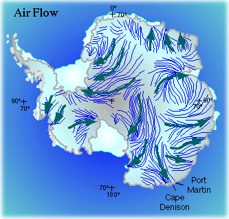
Antarctic Wind Pattern Map
The Antarctic Wind Pattern Map shows that the Antarctic wind
patterns originate in an area off towards the Queen Maud's
Land/Africa side of Antarctica, (on the map, this is to the right of
the Pole). Since the winds are really a matter of the warmer air
emanating from within, this gives us an indication of the location
of the orifice.
This area is to the right of where the Radarsat Map seems to
indicate the opening. Since the geographers are mapping an inward
slope on a flat-map surface, however, some shuffling must occur. Brinsley Le Pour Trench mentions that the
Russian base of Vostok is
on the edge of the "Area of Inaccessibility" (understatement!) of
Antarctica, so the opening must be towards the Pole from Vostok.
Perhaps if we were to drag the area
where the wind patterns originate to a point a bit closer to Vostok
and the Pole, we would then have correspondence between the point
where the Radarsat map indicates the opening, and the area where the
Antarctic Wind Pattern Map shows the origin of the wind patterns.
|