|

by Rick Richards
February 2013
from
RickRichards Website
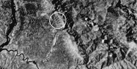
On December 30, 1975, this photograph was taken by the
Landsat II
satellite at an altitude of 500 miles over the jungles of
southeastern Peru at 71 degrees, 30 minutes west longitude in the
Madre de Dios region of the Amazon.
The photo shows eight
symmetrical structures on the edge of the Amazon jungle. These
pyramids are only slightly smaller in height than the
Great Pyramid
of Egypt!

(Above photo was taken from a helicopter.)
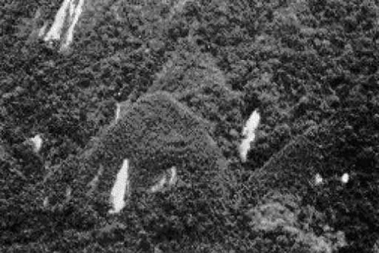
A closer view reveals pyramid-shaped structures with "washouts,"
which are the result of trees failing to get a firm hold onto the
side of the structure. This is a strong indication that the
structures are of artificial construction.
Exploration of these structures is near impossible because of the
necessity of crossing through the thick jungle from the Pini Pini
River (a tributary of the Amazon River) and the ever-present
Machiguenga tribal Indians who consider themselves the traditional
guardians of these "sacred places."
-
Could these ancient pyramids belong to
the Akakor complex hidden in
the jungles of southeastern Peru?
-
Or is this something more amazing?
-
Remnants of
Atlantis?
-
Are these mounds the
12 Atlantean Pyramids
of
MURIBECA?
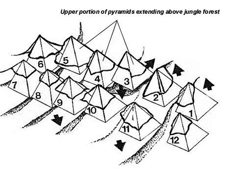
The illustration above depicts perhaps the most significant
archaeological find in modern historical time. Arranged by 'Sacred
Geometry' these pyramids are said to be older than the Pyramids of
Egypt.
The arrows indicate earthquake shifts and fault lines and how the
pyramids have shifted from their original location over the years.
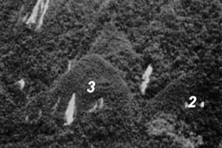
Upper portions of pyramid #2 and #3
extending above the jungle canopy.
UPDATE
December 30, 2004
A visitor to this site recently sent me an
email with information about some explorers who journeyed into this
remote area. Below are two photos of the area where the
pyramid-structures are located that were taken during their
exploratory expedition.
 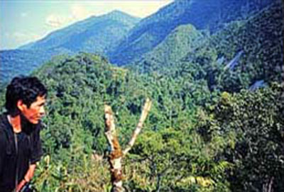
A
B
Photo A shows a person standing on the side of one of the
pyramid-structures' bald, washout areas.
Photo B shows a birds-eye
view of the area in general. IMO, the photos are inconclusive,
especially since no archeological and geological excavation of the
pyramid-structures and the surrounding area was conducted.
But let us assume for just a moment that the mound in Photo A is
indeed a natural feature. It's very smooth slope may still have been
shaved/shaped in the form of a pyramid structure by the hands of a
once thriving civilization.
-
And what about the other pyramid
structures?
-
What do they look like up close and personal in the eyes
and hands of an archaeologist and geologist?
-
Are all their slopes
equally smooth on all sides?
-
Is the angle the same on all the
structures?
-
What is the composition of the rock?
-
What could have
created these eight, cone-shaped, out-of-the-ordinary symmetrical
mounds?
-
Are they nothing more than eight, prehistoric volcanoes in a
row?
1000s of years of vegetation and ground cover would need to be
removed and a serious excavation (digging) of the area would need to
be undertaken to prove conclusively that no ancient civilization
once thrived here.
For these reasons, IMO this area remains a
mystery.
"Whether we get through, and emerge again,
or leave our bones to rot in there, one things for certain.
The answer to the enigma of Ancient South America
-
and perhaps of the prehistoric world -
may be found when those old cities are located
and opened up to scientific research.
That the cities exists, I know..."
Colonel Percy Fawcett
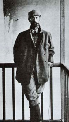
Colonel Percy Fawcett lost his life searching for
the lost cities in the jungles of the Amazon.
|