|

by
Peter W. Merlin
(extracted from "Area
51 - Dreamland - Fifty Years of Secret Flight Testing in Nevada" by Peter W.
Merlin)
from
Scribd Website
Close-up
aerial photo of Area 51 from 1965
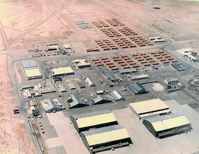
This excellent close-up aerial photo of
Area 51 shows the base as it looked in 1965. Most of the buildings
are still in place today, as part of what is now the north end of
the base. The four large hangars in the foreground are hangars 4-7
(building #200, 202, 206 and 208), which were used for the A-12 and
YF-12 development.
Later they were used for "foreign
technology" items, such as fully operational MiG fighter jets, and
became known as "Red Hat Hangars". Behind them are the U-2 hangars,
the oldest hangars of the base, followed by a group of
administration and operations buildings.
The large building on the left is the Base Supply and Administration
Building (building #265). Next to it is the Dining Hall (building
#267) and the Base Headquarters (#269). On the far right is the
recreation complex, including the building that later became known
as "Sam's Place" (building #170), a gym and swimming pool. Behind
it, partly out of the frame, is the baseball field.
In the background are the old living quarters, which have since been
replaced by more modern and more comfortable quarters. The runway is
out of the frame to the left.
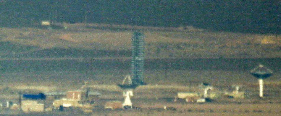
New Tall Structure at
Area 51, January 2006
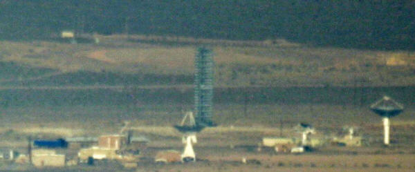
A new tower structure was built near the
RCS range at the north end of Area 51. The shadow of the structure
can first be seen on a satellite image taken on January 17, 2006.
The tower is not present in a September 28, 2005 photo. So we know
that it was built between Sept. 28, 2005 and January 17, 2006.
It appears to be a permanent structure,
with no visible change between January 2006 and June 2007, when this
photo was taken.
The new tower is about 180 ft. tall, with a triangular cross-section
(visible on new satellite images). It is too tall and too solid for
a drill rig. It is located at approximately N 37° 14.782' and W 115°
49.396', west of the sump ponds. This location is near the DYCOMMS
and Quick Kill radar sites at the south end of Groom Lake. It may
hold a new radar array for RCS tests or other radar measurements.
The tower has line-of-sight to a newly expanded remote facility near
N37° 14' 32" and W115° 53' 24". That facility in turn has several
tall poles, although not as solid. The remote facility was expanded
around the same time our tower was built, so there may be a
connection.
The structure looks somewhat similar to the ICECAP tower at the
Nevada Test Site, without the siding. See this LVRJ article from
December 2000 for more information and some photos. Because of the
proximity to the NTS, and the fact that the towers there are no
longer used, it may be a re-used tower originally designed for
underground nuclear tests. But re-used for what?...
There are also a couple of new structures and tall light poles at
the south end of the scraped area in the back. On new satellite
photos it looks like a shooting range, located at N 37° 14.6' and W
115° 50.25'.
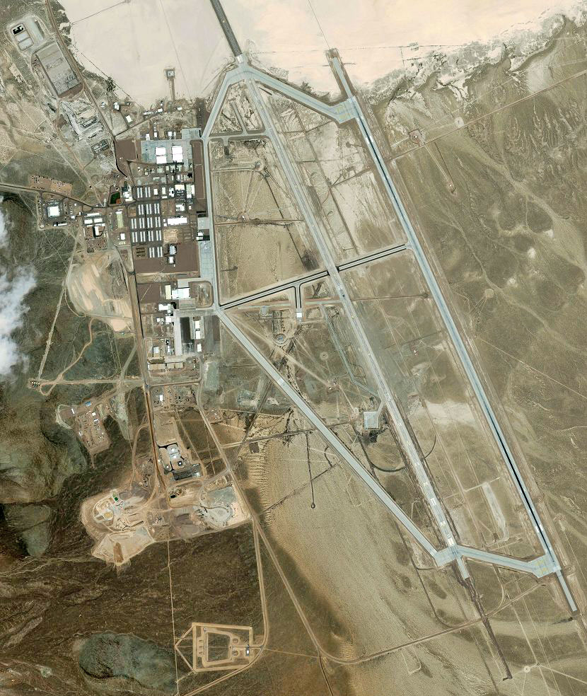
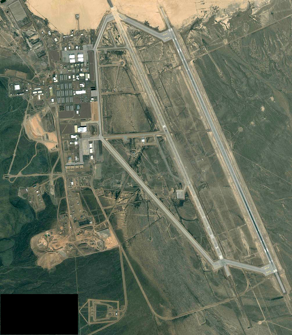
Area 51 Satellite
Image, July 18, 2007
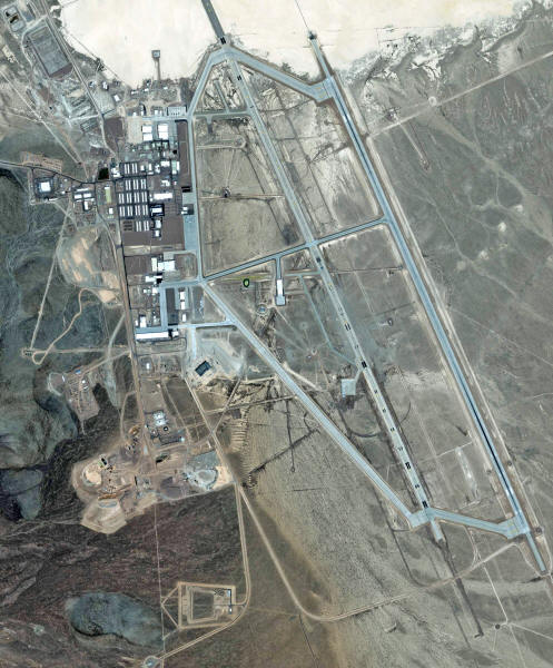
The photo was taken by the IKONOS-2
satellite on Wednesday, July 18, 2007 at 11.43am PDT.
Area 51 Satellite
Image, July 24, 2003
5 meter resolution version of a satellite image of Area 51 taken on
July 24, 2003 by the Ikonos Satellite.
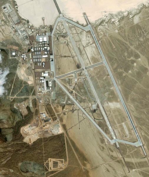
The most notable change over previous
images is the finished new taxiway (with dark shoulders) in the
center of the image. The older runway 14/32 on the left is no longer
used and marked as closed with large yellow X's. The access ramp to
Hangar 19, the arm/de-arm scoot-n-hide hangar, has been extended to
the new taxiway.
The old E-W taxiway has been partially
removed.
The new taxiway is 4625 ft. long and 125 ft. wide. It connects the
southern ramp area with the northern section of the new runway 14/32
on the right. This provides a convenient shortcut for Janets, which
usually land on Rwy. 32 and take off on Rwy. 14. The Janet ramp is
just north of the western end of the new taxiway.
The benefits of the new taxiway are obviously saving taxi time for
the Janets, and avoiding the section of the northern taxiway at the
north end of the old runway that is prone to flooding after heavy
rains. However, both could have been accomplished much easier and
cheaper by widening and extending the existing taxiway east of the
Red Hat hangars.
Most likely, the new center taxiway and the new ramp to the
scoot-and-hide hangar are connected to a new project that is about
to move into the South Ramp area, where several construction
projects can be observed (see below). Access to Runway 14/32 from
the South Ramp would be much faster with the new taxiway. And, as an
added advantage, the most likely top secret development does not
have to taxi past the entire base, with personnel not briefed on
that project.
Other new buildings and construction:
-
A new quonset hut east of the
Consolidated Services Facility
-
Two smaller new quonset huts in
the complex east of the Shipping and Receiving facility
-
A new building (possibly
covering a larger underground structure, possibly a large
tank) in the southern area of the base. Buried pipes or
cables connect it to the Hangar 8 storage building, to
Hangar 17 and to the Steam Plant
-
The southern ramp, north of
Hangars 9-16 is being resurfaced
-
Two large new fuel tanks have
been set up at the site of the old smaller fuel tanks, which
were removed in 2001
-
Runway 14R/32L is now marked as
closed over its full length, including the lakebed overrun
-
Two Janet 737's can be seen
parked at the Janet terminal, as well as three of the
smaller biz-jets. If you look closely you can even see an
F-16 parked on the northern ramp, west of Hangar 6.
Most older satellite images were taken
on weekends, with most of the base vehicles parked at the Janet
terminal. This photo, taken on a weekday, gives a better idea of
areas of activity, based on the number of cars parked there.
These areas include:
-
The parking lot around and north
of the Shipping and Receiving Facility
-
The building complex just west
of the Shipping and Receiving Facility
-
The parking lot in the center of
the base administration offices
-
The area around the Test
Engineering and Support Center
-
The northern ramp area
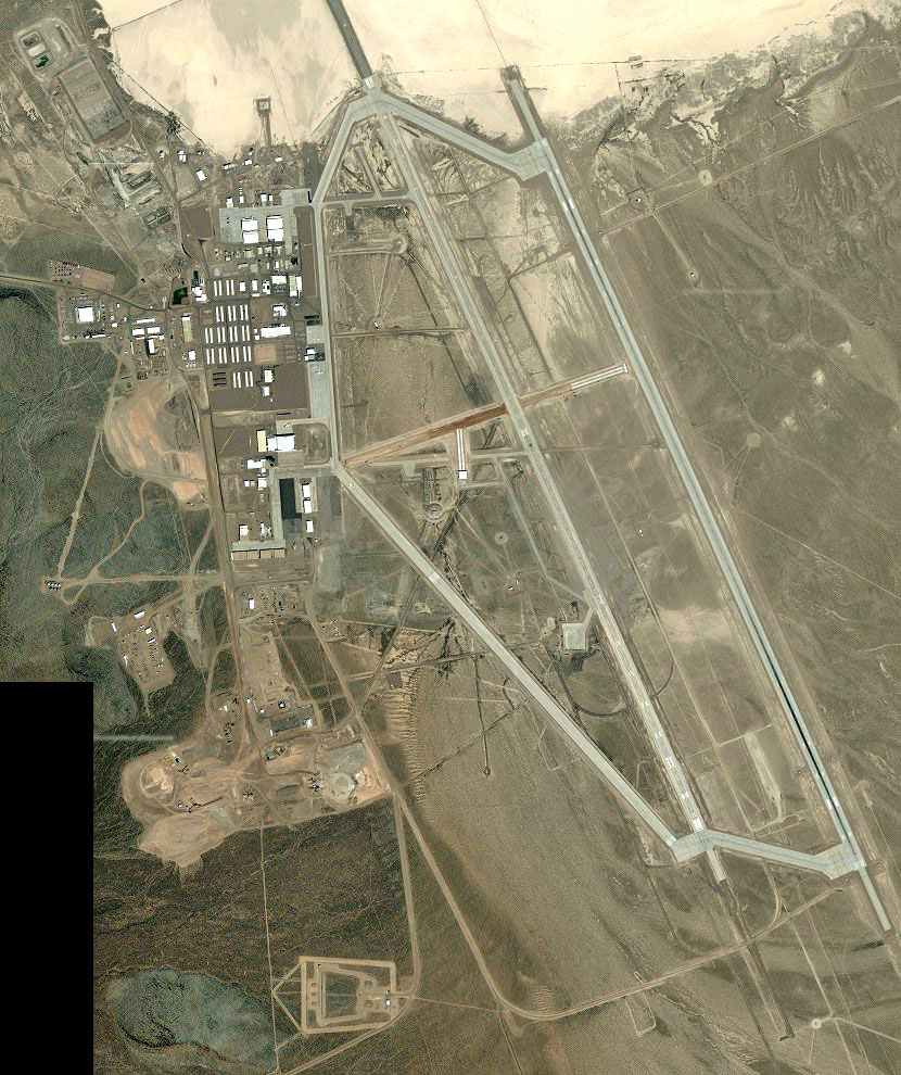
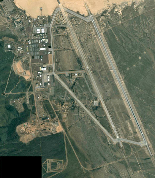
Area 51 Satellite
Image, June 7, 2002
5 meter resolution version of a
satellite image of Area 51 taken on June 7, 2002.

This satellite photo, taken on June 7,
2002, shows the beginning construction of a new center taxiway and
the extension of the ramp that connects it with the scoot-and-hide
Hangar 19. The old center taxiway has been partially removed.
Other new buildings and construction:
-
New foundation for a hangar in
the complex east of the Shipping and Receiving facility
-
The surface of the parking lot
south of the Test Engineering Support Center has been
partially removed. Possibly in preparation of construction
of a new building there
-
Beginning construction of two
large new fuel tanks at the site of the old smaller fuel
tanks, which were removed in 2001
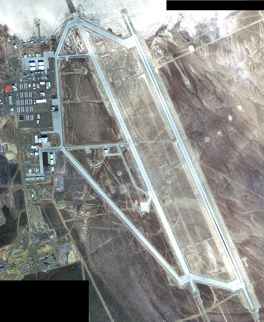
Area 51 Satellite
Image, December 22, 2001
4 meter resolution version of a satellite image of Area 51 taken on
December 22, 2001 by the Ikonos Satellite.
This satellite photo was taken on Saturday, December 22, 2001.
Construction at the Janet ramp is
completed, and now there appears to be some construction at the ramp
west of Hangar 20-23. Judging by the piles of snow in front of
Hangars 9-16 these are not used at the moment. If you look closely
you can see the new markings designating the south taxiway as runway
12/30.
Most of the older fuel tanks south of
Hangars 9-16 have been removed, and you can see the foundation for
two large new tanks.

Area 51 Satellite
Image, April 2, 2000
4 meter resolution version of a satellite image of Area 51 taken on
April 2, 2000 by the Ikonos Satellite.
This satellite photo was taken on Sunday, April 2, 2000. The north
end of the older runway is marked as closed, while the south end is
still in use. The ramp south of the Janet terminal is being
re-surfaced.
During the construction the Janets were
parked on the ramp west of Hangar 20-23.
Area 51 and
the NTS (December 4, 1991)
This satellite photo was taken on December 4, 1991 by "Landsat 4".
It shows Area 51 and Groom Lake in the north-east, Papoose Lake
south of it and the craters from the atomic tests in the 60's at
Yucca Flat and Frenchman Flat west of Papoose in the Nevada Test
Site. The town of Mercury is in the south, and the mysterious Area
19 in the very northwest corner.
You can clearly see the buildings of Area 51 just southwest of Groom
Lake, and the first runway across the dry lake.
The second runway, visible as a white
line south of the lake, is just under construction.

|