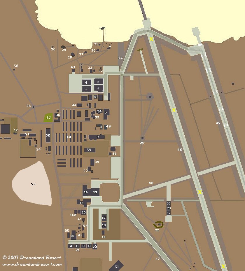
|
# |
|
Building # |
|
Comments |
|
1 |
|
110 |
|
Quick Kill Radar Site |
|
2 |
|
200 |
|
Hangar 4 |
|
3 |
|
202 |
|
Hangar 5 |
|
4 |
|
208 |
|
Hangar 6 |
|
5 |
|
206 |
|
Hangar 7 |
|
6 |
|
217-220 |
|
Old U-2 hangars |
|
7 |
|
265 |
|
Base Supply and
Administration Building |
|
8 |
|
275 |
|
Consolidated Services
Facility |
|
9 |
|
299 |
|
Test Engineering Support
Center |
|
10 |
|
300-335 |
|
Dormitories |
|
11 |
|
400-404 |
|
Janet Terminal |
|
12 |
|
285 |
|
Shipping and Receiving
Facility |
|
13 |
|
430 |
|
Hangar 18 |
|
14 |
|
431-432 |
|
Hangar 18 support buildings |
|
15 |
|
437 |
|
Fire Station #2 |
|
15 |
|
438 |
|
P.E. Building ("Personal
Equipment", flight preparation) |
|
16 |
|
443 |
|
Hangar 8 |
|
16a |
|
441,442,444 |
|
Hangar 8 support buildings |
|
17 |
|
|
|
Hangars 20 and 21 |
|
18 |
|
|
|
Hangars 22 and 23 |
|
19 |
|
|
|
Hangars 20-23 storage
building |
|
20 |
|
470 |
|
Hangar 17 |
|
21A |
|
480 |
|
Hangars 16 and 15 |
|
21B |
|
480 |
|
Hangars 14 and 13 |
|
21C |
|
482 |
|
Hangars 12 and 11 |
|
21D |
|
482 |
|
Hangars 10 and 9 |
|
22 |
|
485 |
|
Weapons Bunker |
|
23 |
|
730 |
|
Hangar 19, Arm/De-Arm,
Scoot-n-Hide |
|
24 |
|
710 |
|
Control Tower |
|
25 |
|
123 |
|
Dish Antenna Building |
|
26 |
|
120 |
|
Range Maintenance Shop |
|
27 |
|
122 |
|
Range B.E. Office |
|
28 |
|
131? |
|
|
|
29 |
|
130 |
|
DYCOMS Radar Building |
|
30 |
|
|
|
DYCOMS Dish |
|
31 |
|
|
|
Helicopter Ramp |
|
32 |
|
103 |
|
Red Hat Quonset Storage |
|
33 |
|
100,101 |
|
Hangar 2, Red Hat Storage |
|
34 |
|
267 |
|
Dining Hall |
|
35 |
|
269 |
|
Old Base Headquarters |
|
36 |
|
170 |
|
Sam's Place, Gym and
Swimming Pool |
|
37 |
|
|
|
Baseball field |
|
38 |
|
|
|
Water Tower |
|
39 |
|
410 |
|
Photo Lab and Precision
Measurement Equipment Lab (PMEL) |
|
40 |
|
412 |
|
Main Security Building |
|
41 |
|
447 |
|
Compressor Building |
|
42 |
|
476 |
|
Steam Plant |
|
43 |
|
|
|
New Scoot-n-Hide shelter |
|
44 |
|
213 |
|
Fire Station #1 |
|
45 |
|
|
|
Runway 14L/32R (new runway) |
|
46 |
|
|
|
Runway 14R/32L (old runway,
no longer used) |
|
47 |
|
|
|
Southern Taxiway and Runway
12/30 |
|
48 |
|
|
|
New Center Taxiway (Spring
2003) |
|
49 |
|
|
|
New Quonset Hut (2003) |
|
50 |
|
|
|
Workshops (?) |
|
51 |
|
|
|
Unknown use |
|
52 |
|
|
|
Old Toxic Waste burning pits |
|
53 |
|
|
|
New smaller building (2003)
with indications of a larger underground structure,
possibly a new buried tank. Underground lines leading to
#20, 41 and 42 from here. |
|
54 |
|
|
|
New Twin Hangar (Late
2002/Early 2003) |
|
55 |
|
|
|
New Hangar east of Hangar 9
(Spring 2005) |
|
56 |
|
|
|
New Extension to Hangar 19
(Spring 2005) |
|
57 |
|
|
|
New Extension to Hangar 19
(Spring 2005) |
|
58 |
|
|
|
New tower structure near RCS
range (Late 2005) |
|
59 |
|
|
|
New Base Headquarters (2005) |
|
60 |
|
|
|
New building east of Hangar
17 (2005) |
|
61 |
|
|
|
New large hangar
(Spring/Summer 2007) |