|

by
Erol Torun
February 29, 1996
from
ErolTorun Website
The following article is the result of
work done in 1988 and 1989 concerning an enigmatic landform located
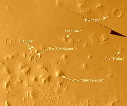
in the Cydonia Mensae region of Mars. The object
pictured here is five-sided, pyramidal, and located a few miles from
the Face on Mars.
Like the Face, the D&M Pyramid is
part of a complex of unusual landforms that may be the product of
intelligent design.
The article is subdivided into these sections:
-
Background - The Cydonia
investigation up to 1988, geological setting, and imagery
selection criteria
-
Geomorphology - Discussion
of the D&M Pyramid in terms of the geological
processes believed to be active on Mars
-
Criteria - Reconstructive
technique, and criteria for analyzing this geometry for the
mathematical and architectural features that suggest
intelligent design
-
Geometry - Diagrams and
conclusions
-
Images
-
References - Numbered
references cited in the above sections
Background
Introduction
Among the images obtained by the Viking mission to Mars in 1976
are some that show peculiarly shaped surface features that are
inconsistent with the regional geology and with surrounding
landforms. Some of these objects are of such unusual morphology that
there is considerable difficulty in theorizing a mechanism for their
formation.
The first of these unusual features to be noticed was a 2 km long
knob that resembled a human face staring straight up from the
surface. The Face was found in the northern hemisphere of
Mars at the boundary between the basin of Acidalia Planitia
and the higher ground of Cydonia Mensae. The object’s
resemblance to a face was noticed by NASA personnel at the
Jet Propulsion Laboratory (JPL), who briefly displayed it
at a press conference. NASA officially dismissed the Face as
a trick of light and shadow. The Face was rediscovered by Vincent
DiPietro and Gregory Molenaar, computer scientists
working at the Goddard Space Flight Center who unexpectedly
found it while working with the Viking imagery. They later found
another image of the Face that had been taken under different
lighting conditions.
Computer enhancement of these images
revealed bilateral symmetry, detail resembling eyes, a nose, and a
mouth, and persistence of this detail under two different sun
angles. Their work was largely ignored by the planetary sciences
community, and was published independently as a monograph (DiPietro
and Molenaar [1]). Subsequent work by Dr. Mark Carlotto [2]
using single-image shape from shading techniques demonstrate that
the Face is not a trick of light and shadow or the result of
variations in surface albedo. It is a three dimensional landform
that, for whatever reason, has the form of a human face. Enhanced
image processing by Carlotto more clearly reveals the
presence of an eye socket in the shadowed side, as well as detail in
the mouth that is suggestive of teeth.
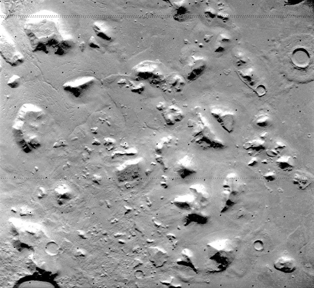
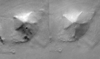
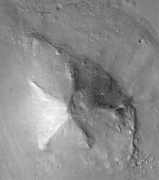
High-resolution
mosaic of the D&M released in September of 2003
DiPietro and Molenaar’s
image processing also aided in the observation of other landforms
that are inconsistent with the local geology. Richard Hoagland,
seeing the work of DiPietro and Molenaar, began
investigating the imagery and discovered the presence of a cluster
of polyhedral objects, later named the "City", that have a
rectilinear arrangement and a major axis aimed directly at the Face.
The Face’s axis of symmetry is itself perpendicular to the City’s
major axis. Hoagland [3] later demonstrated that a square
arrangement of objects in the center of the City, termed the "City
Square", marks the exact midpoint along the City’s major axis, and
would have served as an excellent vantage point for a sightline to
the Face.
In 1983, Hoagland organized and
led the "Independent Mars Investigation", a cooperative
effort of specialists in image processing, geology, architecture,
and anthropology who studied these objects in greater detail. It was
from this investigation that more information began to emerge
concerning geometry and alignments. DiPietro and Molenaar
had previously noted the presence of a massive pyramid, nearly 3 km
in length and 1 km high, to the south of the city and face.
Hoagland, working with a higher quality image processed by
Stanford Research Institute, Inc., observed the object to be a
5-sided, bilaterally symmetrical pyramid whose axis of
symmetry is aimed directly at the face.
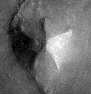
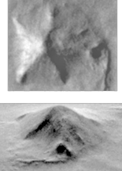
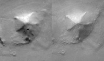
This "flipped" image
of the D&M Pyramid demonstrates
near-perfect symmetry
when the newly revealed angle is used as an axis
Hoagland also noted the alignment of one
edge of the pyramid with the city square and of another edge of the
pyramid with an unusually shaped round hill that lies to the east of
the city on the same latitude as the city square that was named the
"Tholus". Hoagland named the large pyramid the "D&M
Pyramid", after the earlier work of DiPietro and
Molenaar.
The front of the D&M Pyramid (closest to the face) is formed
by two congruent angles, with two larger congruent angles forming
the sides. A fifth angle forms the rear section. The pyramid
exhibits some domed uplift on its right side, and what appears to be
an unusually deep impact crater further to the same side. The
geometric regularity of the D&M Pyramid, together with its
alignment with other enigmatic landforms, has led some to speculate
that the object may have an artificial origin (DiPietro and Molenaar
[1], Hoagland [3], Pozos [4]). Others discount this speculation,
citing the slim likelihood of life evolving on Mars past the
microbial stage, and the indeterminable likelihood of
colonization of Mars by a civilization from elsewhere.
Geological Setting
The geology of Cydonia Mensae is described by Guest,
Butterworth, and Greeley [5]. The region shows a
mixture of smooth and fractured plains, and a small to moderate
amount of cratering. Most relief in the vicinity of the D&M
Pyramid is composed of mesas, knobs, and smooth plains material.
Mesas are most likely the remnants of an earlier surface type that
was removed by erosion, leaving mesas of more resistant material.
Knobs may have been formed in a similar fashion, perhaps from rough,
heavily cratered terrain. The shape of some knob material appears to
have been modified by mass wasting or slumping, perhaps driven by
the freezing and thawing of ground ice, with the excess material
carried off by wind or, under different climatic conditions, by
water or glacial ice.
Further evidence for some type of erosion is provided by the
presence of several pedestal craters in Cydonia Mensae. A
pedestal crater is an impact crater surrounded by an ejecta blanket
that ends in a steep scarp that may drop hundreds of meters to the
surface. The ejecta blanket is presumably composed of material that
is more resistant to erosion than the surrounding surface.
There is a theory that the northern Martian basin called
Acidalia Planitia was once a shallow sea. This would place the
area of Cydonia Mensae under study near the former shoreline. Small
craters in this area appear to have been modified by water erosion,
perhaps by shallow wave action. This would match the observations of
recent researchers that linear features in this area may be
lacustrine deposits resulting from shallow wave action at the edge
of an ancient sea [6].
The morphology of Cydonia Mensae is thus complex and not completely
understood. The region exhibits evidence for previous epochs of
cratering, erosion, and deposition, contributing to the wide variety
of observed landforms and surface types.
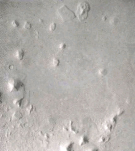
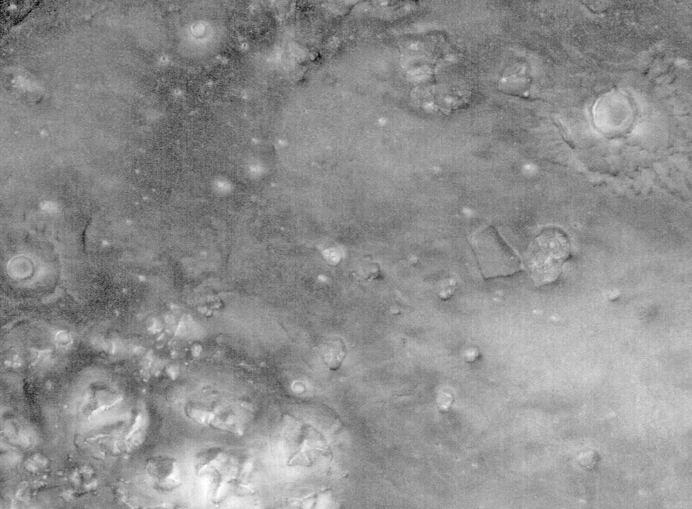
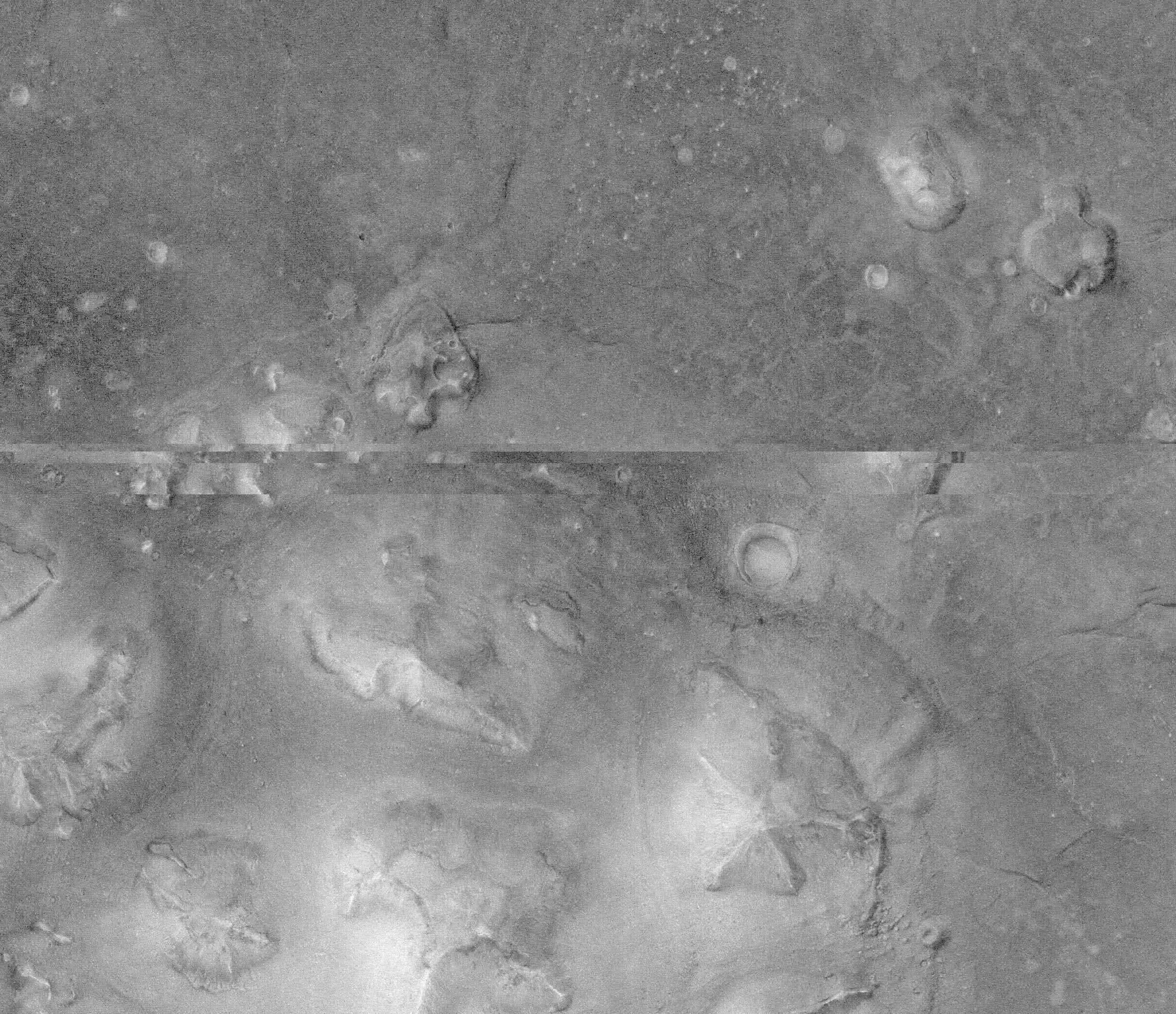
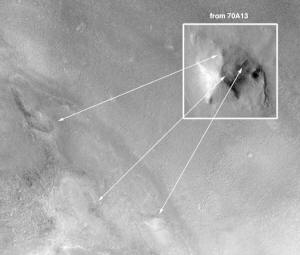
Imagery
Viking orbiter frames 35A72, 70A11, and
70A13 show the D&M Pyramid, located at 40.65N 9.55W. All three
frames were taken close to periapsis and yield a pixel resolution of
~50 m.
|
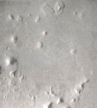
frame 35A72 |
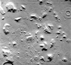
frame 70A11 |
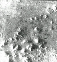
frame 70A13 |
Other frames show the region at
resolutions insufficient for detailed study. The frame selected for
the examination of the D&M Pyramid’s geometry is 70A13. (The
nomenclature indicates the 70th orbit, 13th
frame of the "A" orbiter.) This frame was taken at a higher sun
angle than 35A72 and thus shows more of the object’s structure.
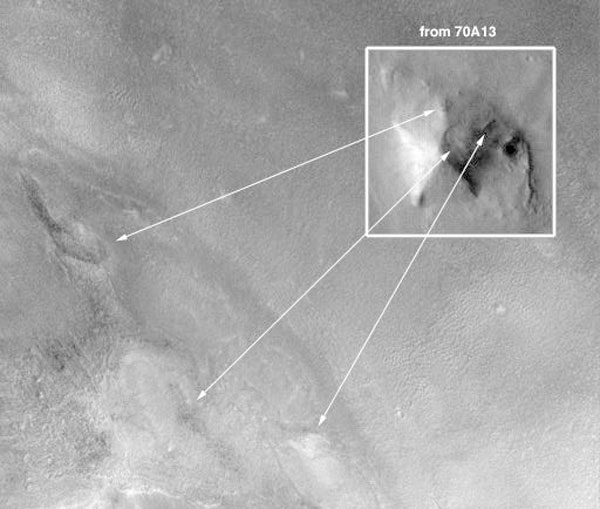
Images of 70A13 used later for angle measurements include an
enhanced closeup of the D&M Pyramid prepared by Carlotto,
and an NGF filtered orthographic rectification of the entire frame
obtained from the National Space Science Data Center, Greenbelt,
Maryland, USA.
To Top
Geomorphology
The hypothesis that the D&M Pyramid is the result of
geomorphological processes requires that some mechanism be proposed
to account for its formation. The processes discussed below are
evaluated in terms of their ability to produce landforms with the
same general morphology as the object under study. Processes meeting
this requirement are then discussed with respect to the specific
morphology of the D&M Pyramid.
Fluvial Deposition/Erosion
It is now almost universally accepted that liquid water once flowed
on Mars, this belief supported by the discovery by the Mariner 9
mission [7] of numerous drainage channels whose form is consistent
with formation by water (as opposed to lava channels, which have
also been found in some areas). Fluvial processes can yield roughly
symmetrical relief, such as the teardrop-shaped islands observed in
many Martian stream beds. But in this case, fluvial processes can be
ruled out as mechanisms for forming the D&M Pyramid as there are no
indications that water ever flowed 1 km deep in Cydonia Mensae
(1 km being the approximate height of the D&M Pyramid. It is also
true that sharp edged multi-faceted symmetrical shapes are not
characteristic of fluvial landforms.
As mentioned earlier, there is a theory that the basin north of
Cydonia called Acidalia Planitia was once a shallow sea
[6]. There are features in the study area that are suggestive of
lacustrine erosion, such as small craters with a "smudged"
appearance that may at one time have been submerged and subject to
shallow wave action. There are also some curvilinear features
suggestive of lacustrine deposition. The D&M Pyramid,
however, bears no resemblance to these features.
Aeolian Deposition/Erosion
Aeolian depositional landforms on Mars typically take the
form of sand dunes which are morphologically similar to those found
on Earth, and have been described by Breed, Grolier,
and McCauley [8]. Dunes may occur singly, in small groups, or
in dune fields, and are transient in form and location. Dunes will
occasionally form star-shaped dunes and crescent-shaped symmetrical
dunes known as barchans, but no dune will ever form a symmetrical
polyhedron resembling the one under study. Flat sides and straight
edges are unobserved in terrestrial or Martian sand dunes.
Aeolian erosion is now the dominant mechanism of geomorphic change
on Mars and has been since the disappearance of liquid water
and the cessation of volcanic activity, both of which have been
estimated to have occurred early in the planet’s history (>2 b.y.
ago). One type of aeolian erosional feature found on Mars that can
assume roughly pyramidal shapes are known as yardangs (Ward
[9]). Yardangs are landforms that have been modified by
deflation (removal of particles by wind) and by the abrasive action
of wind-borne particulates, and typically resemble hills with sharp
edges aligned with the prevailing winds. Their shape has been
likened to upturned boat hulls. Yardangs can occasionally
exhibit sharp edges, roughly flat sides, and bilateral symmetry.
Comparison of the D&M Pyramid with landforms known to be
yardangs immediately reveals some serious inconsistencies. The D&M
Pyramid is an isolated landform with no other nearby objects
exhibiting a similar shape and orientation. Yardangs normally
begin with the downcutting and expansion of low spots, producing a
series of parallel ridges that are gradually denuded into separate
hills. These hills are eroded further by abrasion on the windward
side and by deflation on the leeward side. It is rare for
yardangs to be found in isolation.
Another type of aeolian landform that can be somewhat
pyramidal in shape are known as ventifacts. Terrestrial
ventifacts are normally formed from small rocks that are exposed
to the abrasive action of sand carried by the wind. Multifaceted
terrestrial ventifacts are believed to have been produced as a
result of movement of a rock causing it to present different faces
to the direction of the prevailing winds, a process described by
Sharp [10] and Greeley and Iverson [11]. Large
ventifacts can also exist, produced from boulders and assuming a
roughly pyramidal shape with three edges (dreikanters). These
landforms present a long edge toward the prevailing winds, and a
somewhat flat surface in the opposite direction. The leading edge is
cut by abrasion of wind-borne particulates and the trailing surface
apparently formed by deflation from locally reversed airflow,
mechanisms essentially the same as those that form yardangs.
Five-sided symmetrical ventifacts or yardangs appear
to be totally nonexistent on Earth and Mars. Prevailing winds are
not likely to have shifted periodically with perfect symmetry and
timing. Even if this seemingly impossible condition were satisfied,
another factor would prevent such an object from forming. As noted
above, locally reversed airflow can cut a flat surface perpendicular
to the wind direction on the leeward side of a wind-cut hill. This
locally reversed airflow, and associated surface level turbulence,
would prevent the formation of this hypothetical five-sided
ventifact. Each time the wind shifted to a new direction, the
reversed airflow would start erasing the edges formed by other wind
directions. The end result would not be a pyramidal hill, but rather
a round one.
The overall morphology of the D&M Pyramid, with its straight
edges and flat surfaces in radial arrangement, is inconsistent with
the morphology of aeolian landforms. The nearby Face shows no
evidence of wind faceting, and there are no intervening objects
between the Face and the D&M Pyramid to deflect
wind. Also inconsistent is the presence of a flat-faced protuberance
at the front of the object, a flat surface that should not exist at
the leading edge of wind cut features such as yardangs or
ventifacts. It is reasonable to conclude that aeolian
processes cannot have produced the D&M Pyramid due to the lack of a
plausible mechanism of formation, and the absence of similar
landforms on Mars or Earth.
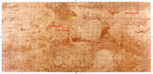
Mars Map
Mass Wasting
The results of downslope movement of large amounts of rock
and/or soil under the influence of gravity has been observed in many
areas of Mars. This process, perhaps driven by the freezing and
thawing of subsurface water, was likely a factor in shaping many of
the irregular knobs found in Cydonia Mensae, as well as the
angular remnants of cratered plateau material to the south. Mass
wasting, however, is unlikely to have formed the D&M Pyramid.
It is uncharacteristic of mass wasting of loose material, or
slumping of single masses, for such material to slide off of a hill
in such a way as to leave behind multiple flat surfaces and straight
edges where none had previously existed.
It is also unlikely that such mass wasting would occur
symmetrically. When mass wasting produces a flat surface, it is
normally due to some previously existing fault or sedimentation
layer that provides a shear surface for the mass wasting or
slumping. An analogous example from Earth geology would be the
failure of a slope consisting of Cretaceous clay that has such
internal layers. If this type of internal layering occurs on Mars,
it is unlikely to occur symmetrically so as to yield a symmetrical
erosional remnant.
Volcanism
Volcanism on Mars was once an important factor in producing
and modifying surface features. Most volcanism appears to have
ceased ~2 b.y. ago, and is described by Carr [12] as having
been concentrated in certain regions; the Tharsis bulge, and
the Elysium and Hellas regions being the most
prominent. There are no signs of significant volcanic activity in
the Cydonia Mensae region, thus drastically reducing the
possibility of any landform in the region being thus formed.
Fluvial erosion of terrestrial volcanoes can produce erosional
calderas that are roughly symmetrical, but these landforms do not
even faintly resemble the object under study. Erosional calderas
form from the downcutting and widening of channels that eventually
merge to form amphitheatre-like depressions in the sides of the
volcano. These depressions extend for most of the height of the
volcano, and are roughly parabolic in cross section, never flat. No
Martian volcanoes observed to date show signs of having been heavily
denuded by rainfall, due to the apparent lack of large amounts of
rainfall in recent epochs. Additionally, the D&M Pyramid has no vent
at its apex, and exhibits a symmetry unknown in volcanic landforms.
Crystal Growth
Nearly all examples of naturally occurring symmetrical polyhedra are
the result of crystal growth. It has been theorized that a
freeze-thaw cycle might have produced unusual crystal growth from
the water believed by some to lie beneath the surface of Mars, but
the D&M Pyramid could not possibly have been produced in this
manner. The size of the object (> 2 km long) would alone preclude
the possibility of it being an ice crystal, as would the fact that
ice crystals have hexagonal symmetry. Crystallization of other
substances can also be ruled out as it is impossible for any normal
crystal to possess 5-fold symmetry. The D&M Pyramid actually
deviates from perfect 5-fold symmetry by being somewhat elongated
along one axis, and is thus even further removed from crystalline
geometries.
There is an exotic form of "crystalline" matter known as
quasicrystals. These exhibit icosahedral symmetry in
three dimensions, and thus have five-fold symmetry planes in two
dimensional sections. Quasicrystals are produced by rapid
quenching of molten alloys of aluminum and magnesium. The materials
and process of formation do not remotely resemble the conditions and
surface chemistry of Mars, and can also be ruled out as a causative
mechanism for five-fold landforms.
The Geomorphic Hypothesis is thus left with no mechanism that
can explain the formation of the D&M Pyramid. This object’s
5-sided shape and bilateral symmetry is unlike any landform seen to
date in this solar system, and even small-scale phenomena such as
crystal growth cannot explain its morphology.
|
All
observations to date of the geophysics of Mars, its
gravity, meteorology, geomorphology, etc., indicate that
Mars is a place where the laws of physics and principles
of geomorphology as we understand them apply, with minor
variations due to gravity and atmospheric density and
content. It is illogical to assume that there is one
small place on the surface of Mars where these same
principles are being violated. Being thus faced with no
known natural mechanism to account for the D&M Pyramid’s
formation, we will explore the possibility that it is
the product of intelligent design. |
To Top
Criteria
Geometric Reconstruction
The hypothesis that the D&M Pyramid may be the product of
intelligent design cannot be advanced simply because there is no
geomorphological explanation, but must be subjected to an objective
analysis, especially due to its location on Mars, a place where life
is not known to have existed. Thus we must first ask a preliminary
question: What are the hallmarks of architectures that distinguish
them from landforms and how may they be objectively recognized and
evaluated?
In searching for the signs of intelligent design, we cannot allow
ourselves any subjective, Earth-based frames of reference. The
observation "it looks like a pyramid" is sufficient to focus our
attention towards further investigation, but proves nothing else.
With subjective appearances set aside, there are a number of
objective characteristics of architectures that can be identified:
Is the object’s geometry inconsistent with known landforms and
geomorphological processes? (i.e. does the object exhibit straight
lines, curved lines having fixed radii, regular patterns, one or
more axes of symmetry, and does the combination of these
characteristics preclude geomorphology as a mechanism of origin?)
Is the object aligned with the cardinal directions and/or with
significant astronomical events?
Is the object collocated with other objects that are also
inconsistent with the surrounding geology? And if so, are they
geometrically aligned with each other?
Does the object’s geometry express mathematically significant
numbers, and/or the symmetries associated with architecture?
The characteristics listed above cannot by themselves establish an
object as being the product of intelligent design. What is required
is a totality of geometric relationships that, when viewed as a
whole, preclude the likelihood of a natural origin. This is
precisely the same "convergence of evidence" technique used in the
photo-interpretation of aerial photography and satellite imagery.
[13]
Methods
In exploring the geometry of the D&M Pyramid, the most conservative
approach possible was pursued. The reasons for this are partly
historical. The Great Pyramid of Egypt has a long history of being
mathematically abused by mostly well-meaning investigators who, in
attempts to "prove" various theories, have subjected the Great
Pyramid to excessively complex measurements and calculations. It is
only the simplest and most elegant of these measurements that are
widely accepted by architects as valid.
Study of the D&M Pyramid’s geometry was therefore restricted to
overall observations of location and symmetry, and to these simple
relationships:
-
The values of observable angles
expressed in radian measure.
-
Examining the ratios formed
between the observable angles for equality with
mathematically significant numbers.
-
Examining the Sine, Cosine, and
Tangent of measured angles for the presence of
mathematically significant numbers.
These approaches were selected due to
their simplicity, their validity in number bases other than decimal,
and their independence from our convention of expressing angles as a
portion of a 360 degree circle.
Technique
As previously mentioned, the D&M Pyramid shows signs of being
damaged on one side, perhaps by a meteoric impact. Some edge and
angle reconstruction was therefore necessary before any accurate
measurements could be obtained. This is a speculative
reconstruction, due to the eroded state of the object. The
reconstructive technique is however the same as that used widely in
archaeology when evaluating sites in which geometry is important, as
in archaeoastronomy.
An NGF filtered orthographic negative of Viking orbiter frame
70A13 was obtained from the National Space Sciences Data Center.
An orthographic projection was necessary to ensure that the geometry
of the object under study was accurately represented on the image.
The negative image of the D&M was projected using a
photographic enlarger that had first been calibrated with a
projection grid. This image was used for the reconstruction,
combined with reference to an unrectified image processed by Dr.
Mark Carlotto for confirmation of detail that was sometimes less
clear in the contrasty original negative.
The most distinct edges on the pyramid, those on the sunlit side,
were marked by visual averaging. These edges were extended to locate
the position of the hypothetical original apex.
-
A straight line was drawn from
the apex through the flat protuberance at the front of the
pyramid to mark what appears to be an axis of symmetry.
-
A line was extended from the
apex to the right front corner, which is sharp and clearly
visible on the Carlotto image.
-
The figure was enclosed, based
upon the left side of the pyramid and the right front
corner.
All visible angles of the D&M Pyramid
were measured (+/- 0.2 deg) and subjected to the tests mentioned
earlier: radian measure, angle ratios, and trig functions. The
results of these measurements are summarized in the following
section.
To Top
Geometry
Evaluation
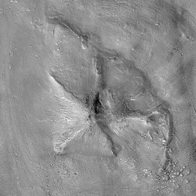
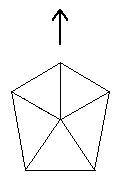
The reconstructed geometry of the D&M Pyramid shows a
five-sided object having facets with differing angles. The object
has bilateral symmetry, with a pair of congruent angles forming the
front, and another pair of congruent angles forming the sides. In
the illustration below, the arrow points along the axis of bilateral
symmetry.
The D&M Pyramid appears to be
positioned with architectural alignment to other enigmatic objects
nearby that have also been studied as possibly artificial. The main
axis of the D&M as illustrated above points at the Face in
Cydonia. Henceforth we will refer to this direction as the
"front" of the pyramid.
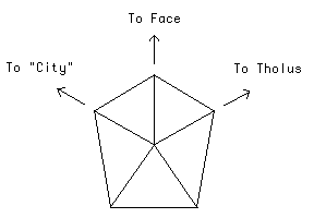
The front of the D&M Pyramid has
three edges, spaced 60 degrees apart. As noted above, the center
axis points to the Face. The edge on the left of this axis points
toward the center of a feature that has been nicknamed the "City" by
the Cydonia investigators. The edge on the right of the center axis
points toward the apex of a dome-like structure known as the "Tholus".
The five-sidedness, bilateral symmetry, and primary alignments were
first observed by Richard Hoagland after studying quality digital
enlargements prepared in 1984 by SRI International from negatives of
images processed by DiPietro and Molenaar. These
events are documented in detail by Hoagland [3] and Pozos [4].
Turning back to the reconstructed geometry, we will now consider the
internal symmetries of this object.
The D&M Pyramid displays a complex interplay between
five-fold and six-fold symmetry. Both symmetries are present
simultaneously, with the front of the pyramid exhibiting six-fold
symmetry, and the "ground level" of the pyramid yielding a 36 degree
angle that is characteristic of five-fold symmetry.
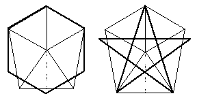
It is worth noting that the practice of
combining symmetries was widely practiced by the architects of
antiquity. It was believed that geometry and certain mathematical
relationships were crucial building blocks of the Cosmos, and
that architecture should reflect these symmetries. These practices
were later revived in the Islamic world and especially in
Renaissance Europe.
The angles formed by the D&M Pyramid when viewed from above
differ from each other. Consequently, they can form various ratios.
These angle ratios were studied to see if the values were
significant, or merely random.
The angle ratios display significant values, with a preponderance of
square roots and fractions involving square roots. Once again, we
have a theme used by Classical architects, who used the square roots
of two, three, and five in laying out the proportions of their
buildings.
For clarity, three of these angle ratios are illustrated below:

The ratios of the shaded angles are
equivalent to the indicated values. In the right hand illustration,
the ratio of the shaded angles is equivalent to the ratio of e
(the base of the natural logarithms) and pi (the relationship
between a circle’s diameter and circumference).
(This ratio of e/pi is nearly equal to the square root of
three divided by two, and the precision of measurement, +/- 0.2 deg,
is insufficient to distinguish between these two possible values.)
A table has been prepared displaying a list of the measured angles,
and the results of the analysis. The square roots of three and five,
and the values of e and pi predominate. The identity of these values
is strengthened by the numerous combinations in which they occur.
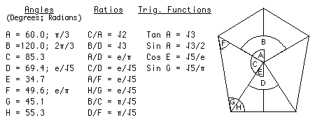
Note that the radian measure and
trigonometric functions of some angles yield the same values
produced by the angle ratios. The geometry thus has a common
contextual thread.
As mentioned earlier in the section on criteria, all of this
geometry is "dimensionless", i.e. it is not dependent on such
cultural conventions as counting by tens, or measuring angles in the
360 system. This geometry will "work" in any number system.
A Speculation Concerning
Tetrahedral Geometry
The aforementioned ambiguity concerning e/pi vs. the square root of
three divided by two can be resolved with the geometry of a
circumscribed tetrahedron.
A tetrahedron is the simplest of the Platonic solids, a polyhedron
having six edges, four vertices, and four sides where each side is
an equilateral triangle. A circumscribed tetrahedron is a
tetrahedron that has been enclosed in a sphere that just touches
each of the four vertices.
The presence of 60 degree angles produces the ambiguity: the Sine of
60 degrees is defined as (√3)/2, and this is very close, but not
equal to, the ratio of e/pi:
(√3)/2 = 0.866025
e/pi = 0.865256
It is this ambiguity that is resolved by
the geometry of a circumscribed tetrahedron.
The surface area of a sphere, divided by the surface area of the
tetrahedron circumscribed by it, yields a very close approximation
of e which shall be termed e’:
e = 2.718282
e’ = 2.720699
When the ratio e/pi is evaluated using
this "tetrahedral approximation of e", the result is precisely equal
to (√3)/2:
e/pi = 0.865256
e’/pi = 0.866025 = (√3)/2
Conclusions
This investigation of the D&M Pyramid reveals a morphology
that is inconsistent with the surrounding geology. The
geomorphological processes observed to exist on Mars not only
fail to provide a potential mechanism for the D&M Pyramid’s
formation, but seem to preclude its very existence. Analysis of the
object’s geometry, and its alignment with other anomalous landforms,
reveal intricate relationships that are numerous and logical, and
are suggestive of highly sophisticated design.
This object has been compared with the elaborate symbolic
architecture of antiquity. While much of the geometry is the same
utilized by Classical architects, it is important to note that the
implementation is totally different. Nowhere in Earth history is
this exact type of geometric symbolism to be found.
The same techniques used for most of this century in air photo
interpretation show that the D&M Pyramid may be artificial,
or may be a natural landform modified by intelligence. The
true nature of this object can be resolved by re-imaging the
Cydonia region to obtain high-resolution imagery of the D&M
Pyramid and the other enigmatic landforms nearby. The issue of
possible ruins at Cydonia is thus the only question involving
extraterrestrial intelligence that can be easily resolved with known
scientific means.
|
The author
wishes to acknowledge Dr. Mark J. Carlotto, The Analytic
Sciences Corporation, the National Space Science Data
Center for the imagery and coordinate information, and
Mr. Richard C. Hoagland for background information and
collaboration on the research described herein.
|
To Top
Images
|
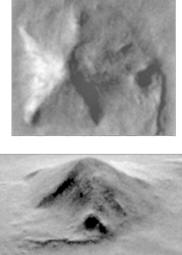
Viking
(1976)
. |
THEMIS image
(2002)
. |
The Mars
Global Surveyor captured this quadrant of the D&M
Pyramid during its 1998 re-imaging of the Face |
|
Partial
frame 35A72 |
A stereo
view of the D&M based on images from Viking and THEMIS |
ESA Photographs
Cydonia
The Europeans Space Agency's Mars Express orbiter has
captured a "widescreen" image of the Cydonia region.
The image shows the
Face, D&M Pyramid, City, Cliff, and other notable surface
anomalies in disappointing resolution.
To Top
References
-
V. DiPietro and G. Molenaar,
’Unusual Martian Surface Features’ Mars Research, Glen Dale,
Maryland (1982).
-
M.J. Carlotto, ’Digital imagery
analysis of unusual Martian surface features’, Applied
Optics, 27, 1926-1933 (1988).
-
R.C. Hoagland, ’The Monuments of
Mars - A City on the Edge of Forever’, North Atlantic Books,
Berkeley, 1987, 1992.
-
R.R. Pozos, ’The Face on Mars:
Evidence for a Lost Civilization?’, Chicago Review Press,
Chicago, 1986.
-
J.E. Guest, P.S. Butterworth and
R. Greeley, ’Geological Observations in the Cydonia region
of Mars from Viking’, J. Geophys. Res., 82, 4111-4120
(1977).
-
T.J. Parker, D.S. Gorsline, R.S.
Saunders, D.C. Pieri, and D.M. Schneeberger, ’Coastal
Geomorphology of the Martian Northern Plains’, J. Geophys.
Res., 82, No. E6, 11,061-11,078 (1993).
-
National Aeronautics and Space
Administration, ’Mars as Viewed by Mariner 9’ (NASA SP-329),
Scientific and Technical Information Office, Washington,
D.C. (1976).
-
C.S. Breed, M.J. Grolier and J.F.
McCauley, ’Morphology and distribution of common ’sand’
dunes on Mars: comparison with the Earth’, J. Geophys. Res.,
84, 8183-8204 (1979).
-
A.W. Ward, ’Yardangs on Mars:
evidence of recent wind erosion’, J. Geophys. Res., 84,
8147-8166 (1979).
-
R.P. Sharp, ’Pleistocene
ventifacts east of the Big Horn Mountains, Wyoming’, J.
Geol., 175-195 (1948).
-
R. Greeley, and J.D. Iverson,
’Wind as a Geological Process on Earth, Mars, Venus, and
Titan’, Cambridge University Press, Cambridge (1985).
-
M.H. Carr, ’The Surface of
Mars’, Yale University Press, New Haven (1981).
-
American Society of
Photogrammetry, ’Manual of Photo Interpretation’, p.109-111
(1960).
To Top
|