|

by BJ
Wolf
Author, Eagles Disobey: The
Case for Inca City, Mars
October 2002
from
Rense Website
Inca City, Mars proven to be part of a
perfectly circular collection of structures!
New photographic evidence shows how Inca City, Mars fits into a
massive complex of anomalous structures that form a perfect circle
on the surface of the Red Planet!
 This
is elegant proof of intelligent construction on a grand scale. This
is elegant proof of intelligent construction on a grand scale.
These massive structures were first identified as potential city
ruins by
Dr. Dan Burisch in the late
1990s. Intensive research isolated many more anomalous artifacts in
the region and led the way to the publication of his findings in the
book Eagles Disobey: The Case for Inca City, Mars. I only
wish Dr. Burisch could see this new evidence.
I know what
he'd say.... "It's so good to be proven right!!!" Unfortunately, he
resides under heavy guard when he is not working at S4,
and any contact with the public has been strongly discouraged.
The
people in charge of the Blk-Ops projects he is working on
were less than pleased that his name and findings with regard to
Mars were ever made public.
Dr. Burisch endured
the loss of his academic credentials rather than back down from his
position that Mars, especially Inca City Mars,
held one of the keys to the question of extraterrestrial life,
and its relationship to human life.
The foundation-like structures seen in the images that Dr.
Burisch used for his initial research were not broad enough to
show the full extent or scope of the find. In fact, when one of the
team sent in a request to see surrounding images, NASA
responded by saying that those frames were private and not available
to the public.
But now that's all changed, thanks to the amazing
improvements in technology, and what seems to be a change in
attitude concerning the release of nearby images.
The MOC camera
permits us to see the full area surrounding Inca City, and as
a result we now know that Inca City is only a small
part of a massive, perfectly circular collection of anomalies!
It's nothing short of spectacular!

from
MalinSpaceScienceSystems Website
|
 |
 |
 |
|
Mars Global Surveyor -
Mars Orbiter Camera
"Inca
City" is Part of a Circular Feature
MGS MOC
Release No. MOC2-319
8 August 2002
"Inca
City" is the informal name given by Mariner 9 scientists
in 1972 to a set of intersecting, rectilinear ridges
that are located among the layered materials of the
south polar region of Mars. Their origin has never been
understood; most investigators thought they might be
sand dunes, either modern dunes or, more likely, dunes
that were buried, hardened, then exhumed. Others
considered them to be dikes formed by injection of
molten rock (magma) or soft sediment into subsurface
cracks that subsequently hardened
and then were exposed
at the surface by wind erosion.
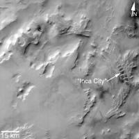
The Mars Global Surveyor (MGS) Mars Orbiter Camera (MOC)
has provided new information about the "Inca City"
ridges, though the camera's images still do not solve
the mystery. The new information comes in the form of a
MOC red wide angle context frame taken in mid-southern
spring, shown above left and above right. The original
Mariner 9 view of the ridges is seen at the center. The
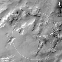
MOC image shows that the "Inca City" ridges, located at
82°S, 67°W, are part of a larger circular structure that
is about 86 km (53 mi) across. It is possible that this
pattern reflects an origin related to an ancient, eroded
meteor impact crater that was filled-in, buried, then
partially exhumed. In this case, the ridges might be the
remains of filled-in fractures in the bedrock into which
the crater formed, or filled-in cracks within the
material that filled the crater. Or both explanations
could be wrong. While the new MOC image shows that "Inca
City" has a larger context as part of a circular form,
it does not reveal the exact origin of these striking
and unusual martian landforms. |
Mars Global Surveyor - Mars Orbiter Camera
Rectilinear Ridges
In South Polar Layered Terrain
("Inca City")
MGS MOC Release: MOC2-35A,
-35B, -35C
MGS MOC Image ID: 568083867.7908
P079-08
March 13, 1998
|
|
 |
|
|
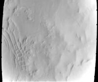
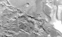
(A) Portion of Viking
Orbiter 2 image 421B64, reproduced here (click on icon) at full
resolution of about 179 meters (585 feet) per picture element. The
outlines of (B) is shown. North is up, sun illumination is from the
top.
|
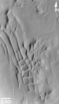
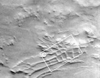
(B) Highest-resolution
pre-Mars Global Surveyor view. Image is a portion of Mariner 9 DAS
#8044333. Click on the small view above to see the image at full
spatial resolution of approximately 100 meters (327 feet) per pixel.
White box indicates location of MOC image (C). North is
approximately "up", sun illumination is from top/upper right.
|
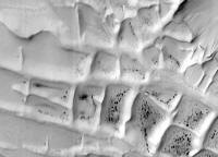
(C) Subframe of MOC
image 7908 reproduced at full resolution, about 23 meters/pixel (75
feet/pixel). Picture shows an area approximately 20 x 14 km (12.4 x
8.7 miles) in size. Sun illumination is from upper left.
|
|