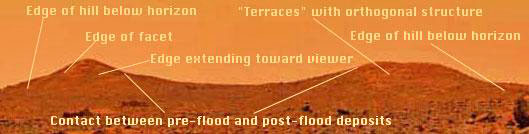
1) What natural process could explain these hills (and the nob to the
north, out of view of the picture but visible in the landing area
photo-map) being the only features that rise above such a vast plain of
hundreds of square miles?
Discussion
It is conceivable that the
catastrophic inundation of what may have been
mountainous or at least hilled terrain was such that all of the
preexisting topography was buried save the two peaks and the
nob, but
that seems a bit coincidental. It is also plausible that the area was a
plain prior to flooding, and the two peaks were the only areas of
topographic relief within miles; examples of such relatively solitary
features do exist on the high plains and in the southwest. However, in
these cases the features are generally more similar to one another, and
are typically erosion remnants, ancient reefs, products of diapirism, or
so called breccia pipes. All of these have relatively easily
identifiable signatures, and none of them are readily assigned to the
characteristics seen in the twin peaks of the subject image.
2) Why is the left hill pointed on top, and the right hill more
mesa-like?
Discussion
This seems a bit more difficult to explain by natural processes, but is
far from conclusive that the features are anything but natural. It seems
reasonable that two features of similar size and composition (an
assumption as stated above) in such close proximity to one another,
subjected to a catastrophic flooding event would likely suffer similar
if not nearly identical destructive forces resulting in their aftermath
appearance being essentially the same. Such is obviously not the case.
It is also possible that the upstream hill (the one on the left) may
have had an original shape that was more angular than that of the
downstream hill, and therefore tended to part the waters, so-to-speak,
much like the bow of a battleship. This could then result in a
convergence of the swirling mass on the downstream peak delivering an
ice tong double impact with combined forces that simply ripped the
downstream hill apart.
Another possible explanation although fraught with some difficulty is
that the right hill is simply older that the left hill, and has been
subjected to a longer period of exposure to whatever natural erosional
forces are present; both physical, and chemical. If this were the case
however, it seems unusual that the older hill would apparently display
more detail than the younger hill. If it was more eroded, then it would
be expected that as a landform it would be more rounded and any detail
would be subdued. That is not the case. It is true that the top of the
hill is flatter, and the slopes are less than those displayed by the
hill on the left, but it is also true that the face of the right hill
retains some peculiar horizontal and vertical color differentiation that
is more well developed than similar linearity on the left hill. It is
also noteworthy that the slope angles of the right hill, where not
masked by the flood-deposited debris, appear to be the original slope
angles.
3) What mechanism could create the variant breaks in slope from the left
hill as compared to the right hill?
Discussion
There are clear breaks in slope in the saddle between the hills on both
sides where the material comprising the saddle fill has been deposited
adjacent to both hills. Close inspection of the left side of the left
hill shows an apparent break in slope as one traverses from the top of
the hill down the slope to a point where the slope angle becomes
flatter. However, the angle of the hill from the top to its base can be
seen to continue beyond this apparent break in slope along the same line
as the steeper natural slope exposed in the upper portion of the
feature. The apparent break appears to be flood debris plastered on the
back side of the hill. Just to the right of the left edge of the left
hill there appears to be another edge, evident only by very subtle
changes in coloration, extending toward the viewer that gives the
impression of a faceted feature; not unlike looking at the edge of a
pyramid.
The right edge of the right slope provides some interesting information,
in that it too continues downward along the upper slope angle beyond the
break in slope that comprises the horizon. There appears to be little or
no debris deposited on this side of the right hill. This could be due to
the plucking action on the down stream side. This process is much like
that observed in a rapidly flowing stream where the downstream side of
boulders is scoured out, whereas the upstream side is subject to
deposition. One might ask why then is the right side of the left hill
intact, and not similarly scoured. A possible explanation is that the
catastrophic flooding from left to right first encountered the left
hill, and as it hit the second (downstream) hill the concomitant
vortices, and backsplash, if you will, filled in along the right side of
the left hill. Indeed, if one looks at the break in slope along the
right side of the left hill, it can be seen that in the saddle adjacent
to the left hill, the debris apron is nearly horizontal in profile.
4) What could cause the faint but discernible orthogonal pattern of
lighter color that seems to emerge from the center of the face of the
right hill?
Discussion
In view of such catastrophic forces that both hills suffered, it is
difficult to explain how one might retain orthogonal structure in a
natural feature, if indeed that is what is being seen. Parallel linear
features of nearly any orientation could be developed as a result of
rapidly moving water, however, retention of similar features at right
angles to such parallel structures, as well as at right angles to the
onrushing forces of the flood, are not so easily dismissed. One possible
explanation is that the orthogonal features represent healed joint sets.
But, if that were the case even more questions arise as to why similar
joint sets are not readily discernible on the left hill, and why the
infilling material in the joints would show such differential and
preferential strength along vertical lines. The same problem arises with
a chemical weathering answer to the phenomenon. If it was chemical
weathering, how is it that the left peak was spared.
Another possibility for a feature displaying linear characteristics at
right angles, is that of columnar jointing of basalt flows. Such
features are readily observed in the Columbia Plateau basalts at many
places, especially along the Columbia River in Washington. However, the
expression of columnar jointing is coherent within each basalt flow, and
is not generally continuous across individual and separate flow
boundaries.
5) Why does the surface of the left peak seem to be so much smoother
than that of the right peak?
Discussion
At this preliminary point in the analysis, I do not have a good answer
to that question. Suffice it to say, however, that perhaps the
explanation given above that the original shape and orientation of the
left hill may have served to protect it somewhat from the catastrophic
onslaught, that is to say it may have presented an edge to the onrushing
water that effectively split the water and divided the force of the
impact.
Dr. Peter Smith in one of his press conferences postulated that the
right hill is a debris pile. This is a possibility. However, it is
puzzling that there appears to be a relatively clear contact between
debris, which drapes both hills in the saddle between the two features,
and the in-place hills. Furthermore, the debris shows no linear features
whereas the in place materials of the right hill clearly show some
evidence of nearly horizontal parallel lineations as well as lineations
at nearly right angles to the horizontal. Regardless, what can be seen
is that the edges of the two hills seem to be somewhat different
regarding their surface tortuosity. The left hill seems to be smoother
and have a faceted appearance, whereas the right hill is more step-like.
It seems reasonable that others may have been interested in the
difference between the two hills because the first high-resolution image
put on the NASA Ames web site was of the top of the hill on the right in
the Presidential Panorama; although it is puzzling to me why the image
was one third hill, and two thirds sky. Regardless, that high-resolution
image just barely includes along its lower boundary the orthogonal
nature of some of the features of the hill. Close inspection of that
image reveals blocky, yet not chaotic orthogonal structure. This is
similarly difficult to readily explain as a result of natural processes
as outlined in the discussions above.
Summary
I have outlined some of the features that I find most interesting, and
worthy of further study, especially since NASA has stated that
the
mission is a success, and that they have accomplished what they set out
to accomplish. Because there undoubtedly will be continued interest and
variant opinions about what the images show, I am concerned that we may
miss a great opportunity to put to rest some of the questions that I as
well as others have raised. Although it is possible in most cases to
develop scenarios involving natural processes that would result in the
features seen on the images, it is also possible that some of the
features are the result of artificial constructs; sufficient evidence is
simply not yet available to say which.
The lander is on Mars. The mission is complete, and a success. It is now
essential that some of the many questions being raised be answered, and
they can be if we simply take the Sojourner and go look. At this point,
it is truly immaterial whether the features are natural or artificial.
What is important is that we find out which is the case. If the observed
features are natural, then we need to understand the processes that
created them in terms of terrestrial analogs--that is exciting. If they
are not natural, then we have an equally exciting future ahead. Suffice
it to say however, that in many aspects, the features do look like
nearly buried remnants of pyramids; the left hill being faceted and more
akin to the general shape of the large pyramidal structures so often
associated with Egypt, and the right hill more step-like and generally
associated with the shape of pyramidal structures in Mexico. Regardless,
natural or artificial at this stage of investigation is not the point.
The point is we are there, we have the capability to look closely at
these features, and others, and we should go look.
Addendum
After viewing scores of posts in the conference center of the
Enterprise
Mission web site I believe it may be worthwhile to try to provide a
modicum of perspective relative to the geologic approach and assessment
of features observed in some of the Pathfinder images. As a geologist,
my analysis, not unlike other technical scientific analyses, begins with
the literature, and whatever information can be brought to bear on a
particular subject. In the instant case the subject being the planet
Mars, and more specifically some of the recent Pathfinder Mission images
being distributed by way of the internet. To become bogged down at this
early stage of analysis in prolonged discussions of imaging technique
and computer compression artifacts, is to some degree to miss the point
entirely.
The point is this. There exists on some of the early
Pathfinder images
features, and items that are difficult to explain using only a geologic
model, and the same features or items become obscured (literally covered
up) or more poorly represented in later images. Furthermore, there is an
eerie silence regarding some of NASA's own multiple working hypotheses
regarding the geology of what is being seen.
My approach to and assessment of the
Pathfinder images began by trying
to identify any anomalous features or relationships of features to
surrounding terrain. The first image that I studied in some detail was
the Presidential Panorama--especially that portion of the panorama that
includes the Twin Peaks (see A Closer Look...). Finding some anomalous
characteristics on the panorama, I then sought to look with a more
discerning eye in the near field. After all, it seemed reasonable to me
that images of nearby objects or features would logically be depicted
with greater clarity and therefore perhaps more detail. I was not
disappointed. Close examination of the images broadcast live on
television by CNN did in fact show some peculiar features in the near
field. This was not enough however to satisfy me that what I was seeing
was not some manifestation of a technique or approach to imaging with
which I am not familiar, or some vestige of the multiple electronic
contortions required to televise such images.
So, I began to search for
a corroborating image that would also show the same objects and
features, in the same anomalous surroundings. Indeed, on frame 80881
downloaded from the NASA Ames Research Center web site there are several
(I've identified over two dozen) objects that seemed to be anomalous
from a geologic perspective, and all of the objects seen on the
CNN
broadcast can be identified in the 80881 image. To aid my investigative
approach in trying to understand the geologic nature of the scene and
place the anomalous objects within a geologic context, I then tried to
categorize the various items and features into broad groups. These were
briefly discussed in my video presented at the Pasadena Conference. To
repeat them here the groupings are:
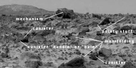
1) Manifolding,
2) Canisters,
3)
Pointy stuff (sorry, but that was all that came to mind in describing
these items), and
4) Mechanisms.
Interestingly enough, all of those
categories of items can be seen on the CNN broadcast image as well as
elsewhere in the 80881 image. At this point, I believed that I did
indeed have the corroborating data that would support the anomalous
nature of some of the items being observed.
Now it seemed to be time to try to articulate just what it is about
these items that seems to make them anomalous--in some way seemingly
unnatural. In brief, it is internally consistent and multiple geometries
and symmetries. What do I mean by that? Well, I'll try to explain. In a
single item (many, in fact most of the items that I consider anomalous)
there can be found multiple combinations of radial geometry,
orthogonal geometry, parabolic geometry, as well as
radial symmetry, and bilateral
symmetry.
Nature produces some amazing and wondrous geometry and symmetry, but for
the most part those geometries and symmetries tend to occur singularly
or at best as a doublet i.e. two symmetries or geometries within the
same item. For example: A tree, in general has obvious bilateral
symmetry and when cut down one only has to view the rings of the trunk
to see well developed circular geometry. Yet, one of the items that I
chose to group as a canister has orthogonal symmetry (rectangular
handles--horizontally opposed), radial or circular symmetry, and a
parabolic nose at the end of a cylindrical object with a base at right
angles to the longitudinal axis of the item. If these things are indeed
a byproduct of some poorly known geologic process, I am at a loss to
identify a terrestrial analog.
Continuing, I looked closely at later images such as 80904, and to my
distress, I found that the items that I was seeking to observe were
greatly changed, or indeed covered over -- they quite simply were not the
same as on the earlier 80881 image. Of course, I am aware of the
difference of elevation of the camera with some of the later images, and
the commensurate potential for paralax-type misidentifications. Many
such items I have dismissed as natural or at least not anomalous,
because of these very phenomena. Yet repeatedly, items of anomalous
interest to me are blurred, changed or covered in later images -- images
that one would expect to be improving with time not deteriorating.
In summary, the items and features that to me are anomalous
from a
geologic perspective are those items or features containing multiple,
internally consistent geometries and symmetries. My approach to
identifying the anomalous characteristics of the various features and
items is the same general approach used by any other serious
investigator trying to develop reasonable working hypotheses in an
effort to understand what makes things the way they are.