|

by Prof. Dr. Afetinan
1954
from
ThePiriReisMapProject Website
Contents
LIFE AND WORKS OF
THE TURKISH ADMIRAL PIRI REIS
INTRODUCTION
Let us take a trip into some periods of the past. The first stop on
this trip will be Turkey thirty years ago. The first quarter of the
present century shows Turkey at the end of the War of Independence,
and the Republic established by Kemal Ataturk (1923). The Turkish
Republic, now thirty years old, was founded on the remains of
another Turkish state, the Ottoman Empire (1299-1923).
For the second stop let us take the year 1929. Let us go into the
Palace of Topkapi of the Ottoman Sultans, situated on one of the
most beautiful spots of Istanbul called Sarayburnu. The palace,
which consists of various buildings, each surrounded by vast
gardens, testifies to the different characteristics of the Ottoman
period. The Turkish Republican Government decided to turn this
palace into a museum.
Discovery of the map of America
In the process of classifying the numerous articles in the
buildings, Mr. Halil Edhem, Director of the National Museums,
discovered a map* (9 Nov.1929)
till then unknown in the world of science. Upon hearing of this
discovery of the oldest map of America Ataturk showed great interest
in the matter. He asked for the map to be brought to Ankara, studied
it and ordered it to be published as it stood and to be submitted to
scholarly research.
*
Map, or chart, "portulano" in
contemporary phraseology, a term used for all such charts showing
the position of ports and based on the idea of the earth being flat.
To study this map for the first time with Ataturk was an immense
thrill. It had been drawn hundreds of years ago on a roe-skin, with
various coloured illustrations and writings on it. As I held it in
my hands, I felt as if I were living in the long forgotten past. My
emotions are twenty-four years old now, but let us, with the same
national and scholarly pride, take a glimpse into the period when
this map was drawn and into the history of the man who had drawn it.
This is one of the oldest and yet most perfect maps of America,
drawn by a Turkish admiral. Now, if you do not mind being centuries
old for a few minutes, come with mc to the XVIth century. In this
third stop our journey suddenly covers a vast ground.
The Sea-Power of the Ottoman-Turkish
Empire in the XVth and XVIth centuries
In the XVth century, particularly after
the conquest of Istanbul, the Ottoman state grew into an Empire. To
secure Turkish domination over the Black Sea and the Mediterranean
she had to possess naval strength, which she did. To get the upper
hand on the Mediterranean, the Turkish forces had to fight against
the Venetians, the Genoese, their usual ally the Knights of St.
John, and the Spanish.
They finally succeeded in acquiring
territorial sovereignty as far as Vienna in west, to the Caucasus,
Iran and Iraq in the east, and south and the as a result of adding
Syria, Egypt, Tunis, Algiers, the Hejaz and Arabia to the former
conquests, formed close contacts on various seas. The Black Sea and
the Mediterranean, including the Adriatic shores, came under the
domain of the Turkish banner.
The fleet carried it across to the Red
Sea, the Persian Gulf and the Amman Seas up to the Indian Ocean. The
great Turkish admiral, Pin Reis, whose life will be our topic of
discussion now, was one of those great Turkish admirals like Burak
Reis, Kemal Reis, Muslahiddin Reis, Barbaros Hayrettin, Turgut', and
Kilic Ah, who, at the end of the XVth and during the XVIth
centuries, won splendid victories for the Turkish fleet, and thus
established Turkish power and preserved it over the seas.
Back to Contents
Biography of
Piri Reis
(1470-1554)
We do not exactly know the date of his birth, but we presume it to
be between 1465-1470. He was born at Gelibolu or Gallipoli as the
Anglo-American world calls it, a lovely coastal town on the Marmara
Sea, which was then used as a naval base. He was named Muhiddin Piri.
His father was Haci Mehmet, and his uncle, the famous admiral of the
period, Kemal Reis.
About the children born and brought up in this
town, Ibni Kemal, the Turkish historian says:
"The children of Gelibolu grow up in
water like alligators. Their cradles are the boats. They are
rocked to sleep with the lullaby of the sea and of the ships day
and night."
This Turkish boy, too, falling asleep
with the sound of the sea in his ears spends eleven years of his
life in his native town. Like other Turkish children of the time, he
acquires his early notions about the world from the ideas at home
and around him, and also from the elementary teaching he was given.
After he is twelve, he joins the crew of his uncle, Kemal Reis.
Thereafter he is no longer an unknown
Turkish youth, but Piri, a careful observer, and a sea-hero whose
name will be remembered in history. He starts his career under the
vigilance of his uncle, and takes part in all kinds of naval
activities for fourteen uninterrupted years. We can follow him at
this period of his life through his book, "Bahriye - On Navigation"
in which he recorded his experiences of the places he visited with
his uncle, and the historical events of the time in a most vivid and
delightful style.
The first fourteen years of Kemal Reis'
life is spent in piracy, as was the custom at the time. After
becoming a considerable power on the sea through his own personal
efforts, in 1494 Kemal Reis accepted official recognition and
position from the Ottoman Government, along with his worthy and
experienced crew.
Several sources confirm the indication - that Piri was with
Kemal
Reis before this date. For instance, during a period when his uncle
was at Egriboz, he says in a passage in the "Bahnye", about the
monasteries of Athos,
"The aforesaid place is a long cape, 80 miles
in length; to the Tracian side lies a dried up channel"
(pp.
117-119)
In his book, the "Bahriye", he makes the following remarks
about the ports on the coast of Athos on the Khalkidhiki peninsula:
"In front of the monastery of
Alaviri stand native rocks, among which there lies a natural
port. It can take only one boat at a time, but since the mouth
of the port lies open to the north, the North and the East winds
do much harm to the boat lying there. It so happened to us once.
As we were lying in harbour the strong East-wind blew across to
the north and damaged our boat, whereupon the monks from the
monastery came to our rescue. They tied the boat down on all the
four sides after which she could not move at all. Thus we were
saved from the storm, and proceeded on our way."
(Bahriye, p. 113)
The remarks refer to the coast of Athos.
For the. third peninsula he gives this information:
"There is a cape at Karaburun. People call it the cape of Kesendere. From this cape
to "Kumburnu" it is all covered with pine woods. Kumburnu is a low
and sandy cape; at the point it grows quite shallow. On it, 100
miles to the North-West lies the city of Salonica."
In another
version of the book he says something different about the same cape:
"The coast of Kesendere as far as
Kum Burnu is very shallow. Along the coast run tall pine trees.
But nobody knows where one can obtain drinking water. To the
humble author of these lines Kara Hasan Reis showed the spot."
In 1494 the Moslem population in Granada
in Spain asked for help from the Tunisian, Egyptian and the Ottoman
Governments. It was just then that Kemal Reis was leading a life of
piracy and used his ships to transport these Moslems over to Africa.
From 1487 to 1493 Piri participated in various activities on these
seas under the supervision of his uncle.
Piri Reis gives remarkable information about the western coast of
the Med4terranean and the islands there, and says the fol lowing
about the island of Minorea of the Balearie Isles:
"They call that port Portulano. It
has a good harbour. As soon as you leave the harbour and turn
along the eastern coast to the north you come upon a natural
spring. It emerges from under a fig tree. Around that spring you
are sure to meet Arab and Turkish boats most of the time, for
they obtain their water there. Further over it stands a
fortress."
(Bahriye p. 532)
During six years of piracy around
various islands and coasts on the Mediterranean, they fought against
other pirates of the time, conquered ships and in bad weather spent
the winter in favorable harbors. Kemal Reis stayed a long time
along the African coast, in Algiers, Tunis and Bona, and formed
friendly relations with the people there having an exceptionally
good reception there. (Bahriye, 1935 Introduction). P. IV Thus while
spending the winter months of I490~I49I in the harbor at Bona they
took part in the battle led by Kemal Reis against Sicily, Sardinia
and Corsica.
One of these battles is recorded by Piri in this way:
"There are some shallow spots along
the aforesaid bay of Resereno; Terranova is a fortress on a low
ground. "Terranova" means "new town" in Sicily. Now, the fore
part of the town is a beach, a good shelter in the summer. The
vessels lie three to four miles away from the land across the
fortress. In the aforesaid harbour we overcame three vessels
this time."
(Bahriye, p.493)
Thus each event is recorded with the
correct dates. For the island of Corsica Piri wrote a new chapter
(pp.523-529) and added a map of the island with detailed
explanations giving the contour of the island as 400 miles, and
said:
"On this island stands a tall
mountain rising from the north to the south. At this date I
counted 25 peaks of this mountain in the eastern part of it.
They looked just like the teeth of a saw. Every one of those
peaks is covered with snow all through the year"
(p.524).
About the inhabitants he says:
"The aforesaid island of Corsica was
a demesne of the Genoese, but later when the French conquered
Genoa, among the others, this island, too, passed over to the
French."
At the time, the ruling sultan was
Bayezid II, son of Melimet II, the Conqueror. After the death of his
brother, Prince Jeni, in 1495 Bayezid started ruling the country
without a rival. Aiming at greater conquests he endeavoured to
reinforce the territorial as well as the naval powers, and for that
purpose brought 'under his banner the various units of Turkish
pirate ships. He invited Kemal Reis to join the imperial fleet.
He did so, with Piri Reis and Kara Hasan
to help him. They all were experienced and trained sailors with good
knowledge of the seas. In such a capacity did Piri Reis take part in
the Mediterranean campaigns under Kemal Reis' supervision.
The first official acknowledgment of Piri's deeds is an account of
the sea fights in the years 1499-1502. The actual commander-in-chief
of the fleet belonging to the Supreme Admiral of all the Sea-Forces
was Kemal Reis. In this fleet Piri was given official command of
some of the vessels. His service in the battles (1500-1502) against
the Venetians was remarkable.
The great advantages that the Ottoman
Empire acquired by the Treaty of Venice in 1502 were made possible
mainly by the brave deeds of these seamen. After this date Piri
works as an admiral of the fleet again, but at his uncle's death
during a sea battle, Piri was deprived of his great protector.
Because of some reason unknown to us, Piri had not taken part in
that battle. There can be no doubt as to how deep a source of sorrow
this loss was to Piri.
The knowledge acquired in the tutorship
of Kemal Reis and the accumulated experience during his life at sea
had secured him fame and a firm position. After his uncle's death he
left the open seas and started working on his first map of the world
at Gelibolu. The portion of the map we now possess is a part of it.
Along with this map he arranged his notes f6r the book "Bahriye"
which later turned out to be a kind of guide book on navigation. In
1516-1517 Piri was given command of several vessels taking part in
the Ottoman campaign against Egypt. Under the command of Cafer Bey
the fleet took Alexandria. With a part of this fleet Piri sailed to
Cairo through the Nile, and later drew a map and gave detailed
information about this area, too.
After Egypt was joined to the growing Empire, Piri had a chance of
making the personal acquaintance of the ruling sovereign, Yavuz
Selim; during the battle of Alexandria. He presented the map he had
previously drawn to the Sultan. After the Egyptian campaign, during
a period of relaxation at Gelibolu, he put his notes on "Bahriye"
into book form.
The reign of Suleyman the Magnificent, who ascended the throne in
1520, is a history of successive victories. Piri's taking part in
the Turkish fleet going to the campaign on Rhodes in 1523 is to be
regarded as only natural.
Piri commemorates the royal command of Sultan Suleyman to him to act
as a guide to Pargall Ibrahim Pasa, the Chief Vizir, in verse (pp.
549-550).
It was after this campaign that Ibrahim Pasa realized the importance
of the "Bahriye" and urged Piri to put the notes into book form and
copy them out again. Piri records that incident, too, at the end of
the book in verse. Because of a storm at sea they cannot proceed on
their way, and are compelled to take refuge at Rhodes. For Piri,
however, this proves to be a good opportunity to make the Pasa's
acquaintance. Piri's frequent references does not fail to attract
the Vizir's attention.
Encouraged by his words Piri rearranges the book to Gelibolu and
copies it all out, and with the help of Ibrahim Pasa presents it to
the Sultan. The date of the book is given in verse in the
traditional way. From the final couplet one makes the date to be
1526 A.D. (923 by the Arabic Calendar).
In his preface to the book, Piri mentions the favourable reception
it received from the Sultan. Later he draws another map and presents
that, too, to Suleyman.
One can follow his life up to 1526 in this book. After this date, we
deduce from the state records that Piri was appointed an admiral of
ships in the south seas. He rendered many services to the government
in this capacity, in the Indian Ocean, the Red Sea and the Arabian
Sea. Thus we find him growing old at the head of his ships. He died
exactly 400 years ago in 1554, as an old man of 84. Mortal though he
himself was, he left behind him immortal works and unforgettable
services to the world of civilization.
With this ends the biography of Piri Reis. Most of it has been taken
from his own memoirs on his experiences at seafaring. On the science
of navigation, Piri was one of the most outstanding scholars of his
time. Apparently, besides his native tongue, he knew Greek, Italian,
Spanish and even Portuguese. He acknowledges his debt to various
works in these languages, in drawing his map of the world.
A galley from the Turkish-Ottoman period. The flags have a crescent
or a sword on red and blue. All these ships were built in Turkish
docks and belonged to a powerful organization. Those serving in this
fleet had to go through a strict course of training.
Back to Contents
The Book
"Bahriyye-on Navigation"
Piri Reis'
Scholarly Works
If Piri were only a helpmate to Kemal Reis, even with the grand
titles and high posts that he had won, he would not be a subject
important enough for the history of civilization today. We would
cite him only as one of the great admirals of the Ottoman Empire
when she was a great power on various seas.
For, at the time, not only were the
Black Sea and the Marmara exclusively Turkish seas, but the eastern
and the southern coasts of the Mediterranean and all the neighboring
islands as well as the eastern coast of the Adriatic were under
Turkish domination. The Turkish banner reigned on the Red Sea and
the Arabian; the Turkish fleet carried it to the coasts and islands
of the Indian Ocean.
To be the ruler of so many seas the Ottoman Empire was bound to have
great seamen. And yet Piri Reis, life and works differ from those of
his contemporaries. He was not content to secure for his country
more powers and victories but left written works on the science of
navigation, which have survived to this day.
 The
Book "Bahriyye-on Navigation" The
Book "Bahriyye-on Navigation"
Piri Reis then young but
quite experienced, traveled on Kemal Reis' ships almost the full
length of the Mediterranean coasts, and on many occasions he was
able to study various Spanish, Tunisian, French and Adriatic harbours. Acquiring information on various geographic and naval
conditions of these legions, he recorded his own observations on
them, and all this formed the basis for his book "Bahriye-On
Navigation".
In it Piri described the towns and
countries along the Mediterranean coasts, and drew maps, charts and
pictures of them. He did not neglect giving important information on
navigation there, either. Reading the book page by page will take us
on a delightful trip along these regions in the XVIth century. It
is, basically, a kind of naval guide book.
He gathered all previous information on
the subject, but added to it other practical knowledge necessary for
sailors on the most important coastal routes, and drew large maps of
all the spots he considered important there. In this way the book
came out not only as a mere guide book, but also it became the
greatest contemporary "portulano" with the most advanced technique
of cartography.
One can see in this book a most significant invention: to make
available all that he could not squeeze into the maps, for his
readers he drew large maps and complemented them with indexes.
The book has many versions. 29 of them exist in the libraries of
Europe and Istanbul. Some of them bear the date 1520 (Arabic 927)
the others 1525 (Arabic 932).
The book was published in 1935, with an introduction, an index and a
facsimile, based on the version now in the St. Sophia Museum in
Istanbul. It has 858 large pages and a section all in verse form,
consisting of 78 pages; the latter is divided into 23 chapters, 1107
couplets in all. Into these lines Piri has put all that he learned
and observed as well as information indirectly acquired, on the seas
of the world, in a style easy to remember and memorize.
The main theme in the book is the Mediterranean coast and the
islands there.
-
In Chapters I and II (pp. 7-19) he explains his aim
in writing the book and also his life at sea with Kemal Reis
-
In
Chapters III, IV, and V (pp. 19-23) he gives information about
storms, winds and the compass
-
Chapters VI and VII (pp.23-29) are
about maps and emblematic signs on maps.
-
In Chapter VIII (p. 29) he
says that one fourth of the seas that cover the earth has continents
on them, and by giving names to each he cites 7 seas.
-
Chapter IX (pp.30-32) is devoted to the
geographic discoveries of the Portuguese.
-
In Chapter X (pp. 33-37)
he discusses Abyssinia as extending as far as the Cape of Good Hope
and wishes that the Turks may drive back the Dutch and the
Portuguese from the Red Sea.
-
In Chapter XI (pp.37-43) on the
globular chart which he calls "the ball of the earth" be talks about
the poles, the tropics, and the equator, and relates what the
Portuguese know about them.
-
Chapter XII (pp. 43-52) recounts how the
Portuguese make voyages from their own country to the Indies with
favourable winds, in a most profitable way. Chapter XIII (pp. 52-56)
is general information on navigation, but it also relates some
sailors' stories based on fantastic rumours.
-
It includes an account of the Chinese seas, and considering that
part of the world as the end of the East, he gives information on
the Chinese people, their customs and traditions and their skill in
pottery.
-
The explanations in Chapters XIV and XV (pp. 56-61) about
the Indian Ocean and the monsoons are valid even today.
-
He also
discusses the wind situations in the Mediterranean and the Aegean
Seas. He describes, here, the implement called the "Indian Measure"
which measures heights, and also gives information about the Pole
Star.
-
In Chapter XVI (pp. 61-66) he describes the Persian Gulf from what
he has heard about it, because then he has not yet been able to
visit that part of the world. He gives a very good account of
pearl-fishing and the spots for it. This piece of information is as
good as modern since pearl-fishing is still performed in the
same way and at the same spots.
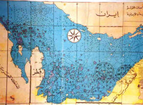
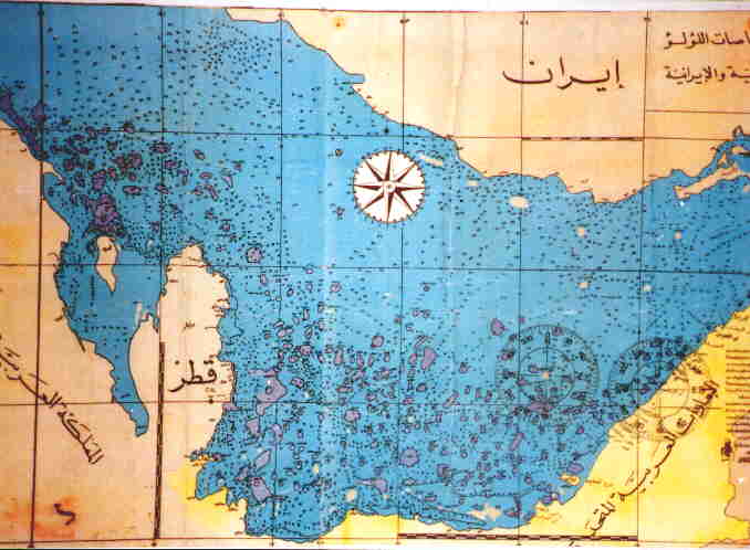
A Map of the Pearling Beds of the
Arabian Gulf
This map was
drawn by hand by Rashid Al Maktoom, in about 1930.
Depth is measured in
"Baa" (fathoms in English) which is 6 ft. X number shown on the map.
Dark areas are earl
beds. The stamped compass rose with degrees is a later addition.
-
In Chapters XVII, XVIII, XIX and XX (pp.67-77) he
calls the Indian Ocean "the Sea of the Negroes", and gives an
account of the coast and the islands there.
-
In Chapter XXI (pp. 77-84) he studies the Atlantic Ocean under two
different names: "the Western Sea" and "The Great Ocean". He says
that the "Western Sea" begins from the Straits of Gibraltar and
extends 4000 miles towards the west.
-
He also informs the reader of
the continent he calls "the Antilia". He says, that there the
mountains contain rich gold ores, and four fathoms deep in the sea
pearl is to be found (p.78).
-
He discusses the history of the
continent and says that it was discovered by sailors. About the
inhabitants there he says that they have flat faces, and eyes a full
span apart from each other; they are large in build and frightful
creatures. He recounts all this on hearsay.
-
He adds to it, though,
some personal experiences as to how he once got a hat belonging to
the natives on some Mediterranean island. The hat was made of
parrots' feathers. There was also an axe made of some hard, black
stone that could cut even iron. In this way Piri wrote most of the
information in the margin of the map of America into this book.
-
In the chapter on this "Western Sea" we read all that is known about
the' discovery of America at the time. Of this he recounts, on
hearsay again, how a certain book from the time of Alexander the
Great was translated in Europe, and after reading it how Christopher
Columbus went and discovered the Antilles with the vessels he
obtained from the Spanish government.
It is quite evident today that Piri Reis came into possession of the
map that the great discoverer had used. He makes a reference to the
Caspian Sea and says that it is a closed sea. He gives no
information, however, about the Red Sea or the Black Sea. Thus in
these 74 pages of verse he was able to gather all the contemporary
information about navigation.
The main body of the book consists of 743 pages (pp. 85-848), and
these are divided into 209 chapters with 215 maps and charts.
This part is written in prose, the aim
being to make it available and easy for every sailor. It begins with
the Dardanelles, then goes on to the Aegean Sea, the coastline and
the islands there, then the Adriatic Sea and the coasts along
Western Italy, Southern France and Eastern Spain; geographic and
historical information about the islands there are given and then
along the Straits of Gibraltar to the African coast as far as Egypt,
then to the shores of Palestine and Syria, to Cyprus and then the
Anatolian coastline up to Marmaris.
At the end of this part he studies Crete
and other islands which he had not previously mentioned. Later
coming back to the Straits of Dardanelles he finishes the book with
a description of the Gulf of Saros.
In composing the work Piri first gives historical and geographical
information and then he discusses the necessary practical knowledge
on navigation. Each chapter contains detailed charts, some in
different colours. Since his method is still used in modern guide
books on navigation and seas one cannot help wondering at the
advanced outlook, which the book presents. On many points the
accuracy of his statements are indisputable. The work, therefore,
must he regarded as very important for the science of navigation.
The great sailor-writer draws maps of and gives information about
the Adriatic coast in general and about the Bay of Venice in
particular. About the latter he says,
"The city of Venice extends to an
area of 12 miles. The whole district consists of parts of land
and parts of an "ear" of the sea. The sea is at some places
quite shallow and at others deep. The people have put piles upon
these shallow spots and upon them built their city. Before the
city was thus constructed fishermen used to come to these lonely
spots, spread their nets and catch fish.
When fishing flourished there, more
people began to come and then to settle there by building houses
over those piles. In the course of time they increased in
number. The wise ones among them thought that they must see to
it that the city they were building must be able to stand for
all time".
(Bahriye, p.422-423).
Then Piri describes the building of the
famous St. Marco, the purpose and the process involved in building
it. He later tells us that the inhabitants live by trade, and that
one has to hire a guide from the fortress of "Yaransa" to go to the
city, otherwise, they do not take the responsibility for any loss or
damages incurred because of the shallow waters.
The final judgment arrived at about the book, after profound study,
is as follows:
"Research work done on it reveals that not a single
statement can be found in it that is not based on facts".
This
becomes very obvious in the ease of Crete when knowledge concerning
the island at two different periods in history is compared.
Unfortunately, however, since this great
work was not published in the XVIth century and was there fore
unknown to the world of science, it has not been as useful as it
could have been. Nevertheless the work still retains its Importance
and value despite the intervening centuries.
Back to Contents
Piri's First
Map of the World, 1513
Let us now concentrate on the first map of the world drawn by Piri.
His own ideas about cartography in general are recorded in verse
form (p. 24). He says that drawing maps requires profound knowledge
and specification. He believes that the slightest error in drawing a
map makes the map useless (p. 25). To see how faithful he was to
this principle of accuracy and exactitude one need only study his
maps.
Foreseeing the development of maritime possibilities of the Ottoman
Empire in the early decades of the XVIth century, Piri realized the
necessity for a map of the world to help those sea-men that would
take voyages on the seas, with practical information. In drawing
this map, as a sailor devoted to his profession, he applied all the
resources then available.
In his preface to the "Bahriye" he
refers to the map and says that he has made use of all the known
maps, including those on the Chinese seas and the Indian Ocean,
which were unknown in the western world at that time. He also
records that he presented it to Sultan Selim II. From a note in the
margin hand-written by the author himself, we conclude that the map
was drawn by Piri at Gelibolu between March and April of 1513
(Arabic 919).
In one of these notes Piri cites his
references and some twenty maps he had made use of. Eight of these
were new maps of Mappa Mundi, four drawn by the Portuguese, an
Indian one in Arabic, and one by
Christopher Columbus on the western
hemisphere. The most important point to be noted here is the fact
that Piri had a map of Columbus, in his hand when 'drawing' his own.
He himself refers to it in the "Bahriye" (p.82) when talking about
Columbus' discovery of the Antilles.
This can be accounted for in the
following way:
he came into possession of the map
when he was with Kemal Reis on the Spanish shores on the
Mediterranean. In a reference to the shores of Valencia he says
that once on those shores he and Kemal Reis took, at a single
engagement at sea, seven Spanish vessels.
(Bahriye, p. 596).
We have already noted how he refers to
the "Antilia" and the natives of the Antilles.
In one of the marginal notes on the map
Piri mentions a Spaniard who
had taken part in three of Columbus's two expeditions and was later
taken prisoner by Kemal Reis. This Spaniard had given a most
interesting account of Columbus to Kemal Reis. It is quite possible
that he was captured during the battle when some of those articles
belonging to the natives were also taken.
The map of Columbus in Piri's possession, was drawn in 1498, and,
since we know that Kemal Reis and Piri had fought against the
Spanish in 1501, Piri's acquisition of the map during that war is
quite plausible.
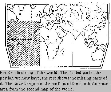
Although Piri had drawn a map of the whole world, the portion we now
have of it is only of the western coasts of Europe and Africa, the
Atlantic Ocean, Central and North Americas.
The map is drawn on a roe-skin in various colour. Like other
contemporary maps it has no lines of longitude or latitude.
Nevertheless We can see two rose-compasses one in the north and the
other in the south. Each of the roses is divided into 32 parts and
the division lines are extended beyond the rose frames. Each
wind-rose is equal to one sea mile, as is shown in the measurements
on the areas near the wind-roses. The map is 90/65 centimeters in
size.
It is in various colour and is decorated with numerous
illustrations. In the capitals of Portugal, Marrakesh and Guinea,
there are pictures of their respective sovereigns. Besides these, on
Africa there are pictures of an elephant and of an ostrich, and on
South America of lamas and pumas. On the oceans and along the coasts
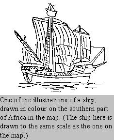
we see illustrations of ships. On both the lands and the seas there
are entries sometimes relevant, sometimes irrelevant of the
pictures. They are all written in Turkish, and can also be found in
his book "Bahriye".
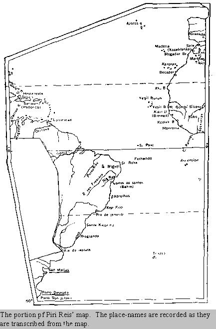
You can follow the entry-notes beginning from the north-west corner,
turning southward, then proceeding along the perimeter, and finally
continuing in a winding fashion towards the center.
Reading some of the notes is really difficult.
The map is
transcribed by experts HERE.
The
mountains are drawn in outlines and the rivers are
marked with thick tines. In the map Pin Reis adopts and applies the
rules of emblematic signs mentioned on page 28 in the 'Bahriye".
Thus he indicates the rocky regions with black, the sandy and
shallow waters with reddish dots, and the rocky parts in the sea
which cannot be seen by sailors with crosses.
A close study of the map shows us how
faithful Pin was to his sources. In the bibliography attached to the
map he claims that his map is as sound and accurate for the seven
seas as the map of the Mediterranean.
From the various Turkish names on these
coasts like Babadagi, Akburun, Yesilburun, Kizilburun, Altin Irmagi,
Guzel K6rfcz, Kozluk Burnu, Iki Hurmalik Burnu etc., we deduce that
in his drawing he made use not only of the Portuguese maps in his
possession, but also of the information supplied by various Turkish
sailors faring along these coasts. In his drawing of the coastline
and in his marking of the sites of importance on it we again notice
his remarkable accuracy. He is quite accurate also in the positions
of the Azores, Madeira and the Canary islands.
As for the northern part of the map, we see here how Pin Reis
benefited by the new Portuguese maps and recorded on it the
discoveries made before 1508 on the North American Coast by Amerigo
Vespucci, Pinzon, Juan de Solis. Some of the place names on the South
American coast, like Santa Agostini, San Megali, San Francisco, Port
Rali, Total Sante, Abrokiok, Cav Frio and Katenio show a close
resemblance to their modern forms.
Except for the two entries about the
name and the date of the map, all the other entries are written by a
calligrapher. This fact can account for the changes to be observed
in various names on the map. Another reason for this may easily be
the inadequacy of the Arabic script then in use, for expressing
Turkish words.
All the principal rivers in South America are marked on the map,
though the names are not written It is remarkable that he should
have shown the river La Plata on the map, when Pinzon and Juan de
Solis passed by it and from all accounts, never even noticed it.
Outside the parts relating to Columbus' map, the scales in miles are
astonishingly accurate. The land extends unimpeded to the west from
the south of lie Plate.
Evidently this part of the map is drawn
in accordance with the Ptolemic idea of the world, as is also
observed in Mappa Mundi. Eight years later, when he had finished his
~ in the preface to the book he affirms that, further south it is
not land but sea, which shows that he was following le later
discoveries with careful attention. And yet, from it point of view
of the historical importance of these geographic discoveries, this
map is particularly significant for Central America.
Close studies here confirm the idea that the map possesses all the
important information that was on the map of C. Columbus drawn and
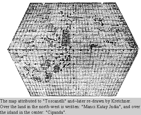
sent to Europe in 1498 and also on the map of Toscanelli that
Columbus had in hand when he first ventured Out on his voyages. This
part of the map contains many imaginary islands with a picture of a
parrot on each.
The island of Trinidad is written as "Kalerot",
which probably is derived from a cape on this island which Columbus
called "Galera". Porto Rico is named here San Juan Batichdo, and on
its eastern coast is drawn the picture of a fortress. There is,
however, another island to the west of Trinidad, again with a
picture of a parrot near which is written San Juan Batichdo.
Drawing various islands on the South
American coast opposite Trinidad shows the influence of Colombus,
who believed this newly discovered continent to be a group of
islands. This is to be observed also on the island of Haiti, called
by Columbus Hispanyola, and by Piri the Island of Spain: instead of
showing it extending from the east to the west, as it does, he shows
it extending from the north to the south, which proves that Columbus
took this island to be Zipang, i.e. Japan as Marco Polo calls it and
in accordance with Marco Polo's descriptions of it, the island is
given this mistaken position.
The real Antilles are shown on the map not as islands, but as C.
Columbus believed it to be, as a continent. Hence Pin calls Central
America "the County of Antilia", and the North American coast "the
coast of Antilia".
It is true that at a certain spot quite
near the North American Coast there is marked an island called the
Antilia, but evidently that stood for the legendary island popularly
regarded as fabulously wealthy and prosperous at the time when
Columbus first started on his voyages. It is to be noted, however,
that beside the island is a note that states that, contrary to the
common fallacy, the island is not prosperous.
Cuba, too, is shown as a continent in
accordance with Columbus' firm belief. So confident was Columbus in
this that while he was near the coast of Cuba in 1494 he had his
conviction recorded by the notary public on the boat, Fernando Perez
de Luna, and asked all the crew to sign it, as we can now see from
the document signed on the 12th June, 1494, which declares that,
since it is quite evident that this is a continent, thereafter
whoever attempts to contradict this statement shall be fined to
10.00 Maravedis pieces and also his tongue shall be cut out.
Undoubtedly the reason why Pin, too,
shows it as a continent was not because he was afraid for' his
tongue, but because he would not 'question the veracity of a piece
of information given by such an authority as Columbus, who had been
to those
 parts of the world several times. parts of the world several times.
Cuba is shown as a
continent also in the map of Columbus dated 1498, which formed the
basis for Pin's later on; in the rough sketch drawn by Christopher
Columbus' brother, Bartholomeo, in 1503, in the map of the world
made by Ruysch in 1508, and even in the marine map by Waldeesmuller
in 1507.
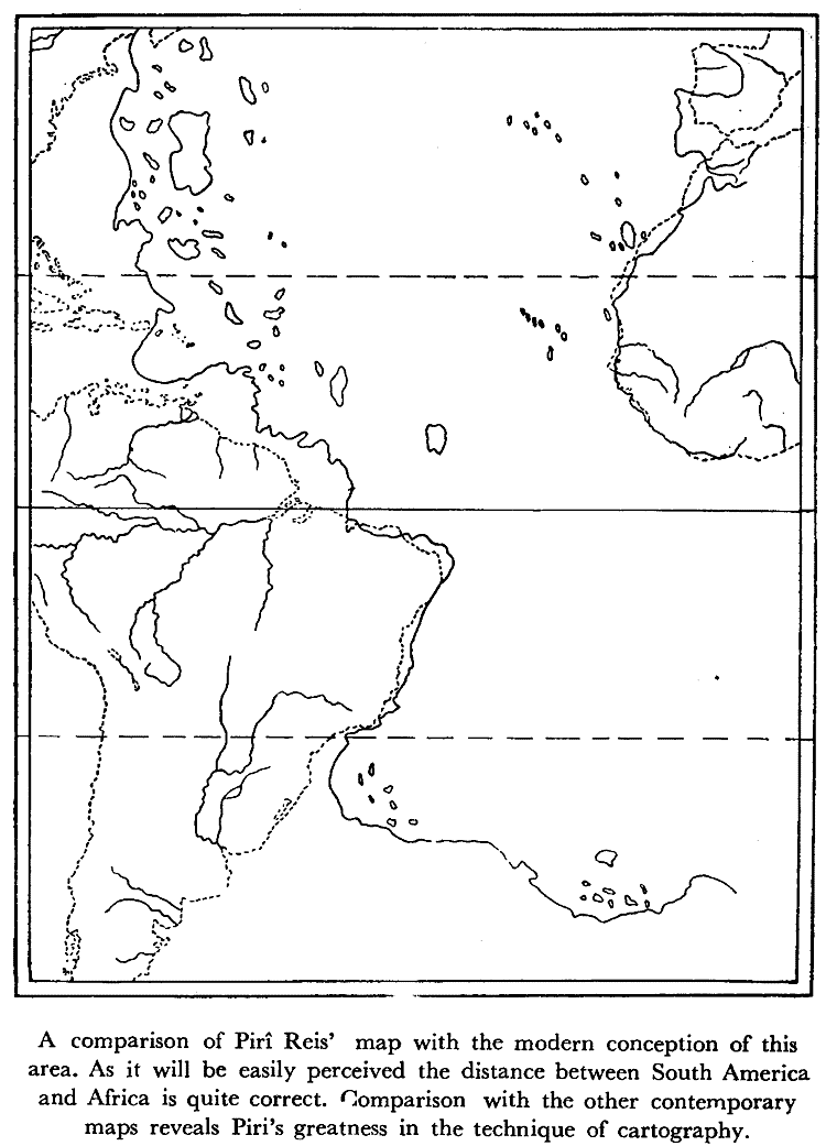
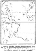
A comparison of the Piri Reis map
with the modern conception of this area. As it will be easily
perceived the distance between South America and Africa is quite
correct. Comparison with the other contemporary maps reveals Piri's
greatness in the technique of cartography.
Piri calls the eleven islands on the south-east of Haiti "Undizi
Vergine," which shows that the number of the islands is not
expressed by the word "onze" which means eleven in Spanish but by
its equivalent in Columbus' mother tongue, Italian.
This is another
indication of how faithful Piri was to Columbus' map, Keeping close
to the information of Columbus' map which apparently possessed all
that was on the earlier Toscanelli map, Pin harided down to us the
oldest map of America and informed us about various aspects of the
most important phase in the history of the discoveries.
By recording the explanations given by
the Spaniard who had taken part in the three expeditions of Columbus
and was later captured by Kemal Reis, he related the story of these
discoveries from an original source free from the later legendary
tales which have grown about them.
Scattered about the map are some other entries which also enlighten
us about various details in the discoveries. Beside the picture of a
ship near the Azores is written that this Genoese vessel came from
Flanders, was shipwrecked, and that the survivors discovered these
islands. From another entry we learn that the sea there is the
Western Sea, but the Europeans call it the Spanish Sea, and after
the discoveries of Columbus' the name is changed to Ovasana, i.e. "Osean".
By a picture near the island of Santiago is a note stating-that the
names of these places were found and given by a Genoese sailor
brought up in Portugal. In anther entry close' to the picture of a
ship drawn near the South American coast he summarizes all the
information given in a map by Nikola di Juan who was shipwrecked
there. In one of the notes on the Atlantic Ocean he mentions the
treaty of "Tordesillas" 1599, and a certain line that divides the
Spanish and the Portuguese possessions.
Towards the north, on the map is a picture of a fish on which is
drawn a woman and a man making a fire, nearby is another ship and
three people in a boat. This is the story of' Santa Brandon which
was very popular in the middle ages, and was recorded in the
"thousand and one night" stones. But Piri does not neglect to add
that the legend comes down not from the Portuguese but from 'the old Mappa Mundi.' This shows that the Turkish geographer made use of many
sources and did not neglect the latest information nearest to his
age, and that he was very careful about his bibliography.
From various kinds of research work done on the' map we conclude
that compared with the other maps of the period, Pin's is the most
perfect and original. It will interest the Americans as one of the
oldest maps of their country, and we Turks will always be proud that
the author of the maps was one of us.
Back to Contents
The Second
Map of America
Fifteen years after
this first map, Piri Reis drew a second one, again at Gelibolu. Like
the previous one it bears his signature. Unfortunately to-day we
have only a small portion of it i.e. a small portion of the western
hemisphere. It is 68/69 centimeters in size. Ornamental figures are
drawn in the margins and most of it is in colour.
There we find the northern part of the Atlantic Ocean and the newly
discovered regions of North and Central America. There are four
wind-roses on it. The tropic of Cancer is shown here, though it was
not on the first map. There are also scales of mules on it, each
with twenty divisions.
From the notes beside them we gather
that the distance between the divisions stand for 50 miles, and that
between two dots for 10 miles. The scales here are bigger than in
the previous one. We see Greenland in the north and the Azores
towards the south. Some of the latter bear the names "San Mikal",
"Santa Mariya", "Euriko", and "San Jorjo". To the south of Greenland
two large pieces of land are shown; the one in the north is called
Baccalao.
On the map there is a note saying that
Baccalao was discovered by the Portuguese. In another note further
down near "Terra Nova" he says that though these coasts were
discovered by the Portuguese ,all is not known as yet, and only the
parts that have been discovered are shown on the map. Further south
still one can see the Peninsula of Florida drawn very much as we
know it today. He calls it San Juan Batisto. The name was first
given to Porto Rico on the previous map.
The pieces of land seen at the side are the peninsulas of Honduras
and Yucatan, discovered in 1517 and 1519 respectively. Unlike the
first map, drawn under the influence of Columbus, the islands of'
Cuba, Haiti, the Bahamas and the Antilles are drawn quite
accurately. One can read the words "Is! di Vana" over Cuba. Although
there are numerous names along the coast of Venezuela, very few can
be read. Among the legible words are San Cilormi, Monte Krago,
Detonos, Die Sagram, Ponte Sogon, Didas and Sare.
In this second map the drawing of the coastlines shows greater
improvement in technique and also close resemblance to the modern
conception of these areas. The stony and rocky sections are given
special care. There is, however, a slight distortion in the map from
the true position of the continent as we know it today-
This error was committed, due to neglect in not taking into
consideration the ten to thirteen degrees of difference in angle on
the contemporary compass. This error is to be observed in all the
contemporary maps without any exception.
On this map, as on the previous one, there are some explanatory
notes, but they are recorded more briefly. The note on the left-hand
corner of the map, under the scales with the long and ornamental
points, gives the signature of the author as well as the date 1528
(A. H. 935). Beside the measurements there is a note indicating the
mileage, where he says that the distance between two sections is 50
miles and between two dots 10 miles.
Over the second set of scales further north he says again that the
distance between two sections is 50 miles and between two dots 10.
The idea in the two statements is the same but one or two words
differ.
Beside place-names in the notes near Labrador he says,
"This is Baccalao. The Portuguese
infidels discovered it. All that is known about it is recorded
here".
From the position on the map we
understand that these coasts are of "Terra Nowa". Today we know that
the Portuguese explorer, Carl Real, discovered Terra Nova in 1500,
and his brother, Miguel Real, a year later in 1501, discovered
Labrador.
Though part of the note over Central America is damaged what remains
is quite interesting. "Dividing the land... to find where the sea
begins... the vilayet that... beyond which", can be read.
Here there is a reference to an explorer who planned to cross
overland to reach the ocean. It is quite possible that Piri meant by
that Balboa who crossed Central America and reached the Pacific
Ocean in 1513.
Another interesting term used on the map is what he calls the
tropics: "Day's Lengthening". In his own words the explanation runs
as follows: "Bu hat gu"n gayet uzadigi yere isarettir" which means
that these lines indicate the part of the world where the days grow
longer.
The line drawn over Cuba should, of course have been drawn further
north, and the peninsula of Yucatan should have been put entirely
below it; but that much accuracy could not be expected of the
cartographical technique of the period.
Such technical errors can be observed also in other contemporary
maps. We should, therefore, acknowledge the greatness and value of
the work among other maps of the period after pointing out briefly
to its various merits and demerits.
As it can be easily observed from this map, Piri Reis continued
following the new discoveries with great interest. It is remarkable
that, by taking into account the results of the new discoveries, he
should correct in this map the inaccuracies of the first in which he
was misled through his unquestioning confidence in Columbus' map. In
this second map Piri Reis showed only the parts of the world that had
been already discovered and left the unexplored areas blank,
explaining this by the fact that they were as yet unknown.
Thus, Piri
proved, once again, how he observed the principles of scientific
methods in drawing this map.
Back to Contents
Comparison of
Piri Reis' Maps with Other Contemporary Ones
The maps or charts called portulanos, 1. C. handbooks On navigation,
were first drawn in the thirteenth century. We do have examples of
such works previous to that period, but the kind that could bear
comparison with Pin Reis' are mainly in the fourteenth to sixteenth
centuries.
The first portulano in Europe is found in the work of Adamus
Biemensis in 1076. Then comes the map called pisane, presumably
drawn in the thirteenth century The maps which appear after that
bear the name of the author and the date of the drawing. The
earliest among these is the portulano of Pietro Visconti, dated
1320. To this is added a section of Marino Snudus' work, under the
name of "Liber Secretaruin Fidehum Crucis".
Thus, considering the development of this type of handbook and
charts, it will be useful to make a short comparative review of
other such contemporary works, especially of maps showing America.
The portulanos and the handbooks written after the fourteenth
century mention the island of "Brasil", and in 1414 the island of "Cipangu"
and the "Antilia" are shown. It is believed that between 1474 and
1482 Toscanelli sent a portulano together with a letter to
Christopher Columbus.
Unfortunately, these documents have not survived. In that letter he
is supposed to have said that according to the testimony of several
who had gone that way, if one kept on going to the west he was bound
to reach Asia eventually.
According to what De la Ronciere wrote, this Portuguese map was
drawn between 1488 and 1493. A photograph of the map will be found
on another page in this book, together with the portion that
Kretchner re-drew (p. 39).
The information spread all over the world after 1507 when Amerigo
Vespucci wrote in a letter that it was a new continent and he called
it "Novus Mundus". St. Die, who published the letter, suggested the
name "America" for it.
On the other hand there are some who claim that the name of America
was adopted because the natives of Nicaragua called a part of their
land "America". It is true that in the first half of the XVIth
century this new continent drew the attention of geographers, and
that resulted in various maps being drawn of it. Piri Reis was one
of these cartographers. Hence, a comparison of his works with sonic
other contemporary maps drawn between 1507-1550 will reveal to us
the greatness of Piri maps as historical documents in the discovery
of America.
Back to Contents
Conclusion
As it has already been stated, at the time of Piri Reis, the
Ottoman-Tuikish Empire was the dominant power over the Black Sea,
the Marmara and the Red Sea, and was fighting for prevalence over
the Aegean, the Mediterranean and the Indian Ocean. For such a
position the Empire had to have a fleet equipped with all the latest
weapons. The State Archives give us some most interesting and rich
material concerning these organizations.
What the author of this booklet wanted
to show, however, was only some of the characteristic features of a
Turkish sailor and scholar, the writer of a marine guide-book and
the cartographer of two maps of the world, a man who had taken part
in numerous private and state enterprises on various seas.
Close studies of the maps reveal to us the fact that when compared
with other contemporary maps these prove to be composed with a most
advanced scientific spirit and method. The two maps of Pin complete
each other. We are indebted to such valuable guides in the world of
scholarship for enlightening us in this most important phase of the
geographic discoveries. In any history of the period they must he
taken as data of direct information.
The bibliography will show the wealth of
publication on these works. The author has always taken intense
pleasure in studying this subject on various occasions, and thought
it to be her duty to share some of the information with an
increasingly larger group of readers.
Piri Reis' life and works show not only the great heroic and warlike
qualities of the Turks in the XVth and XVIth centuries, but also
their contribution to the world of scholarship and civilization. Pin
lived in an age when the Turkish culture was fertile in every field.
The XVIth century is universally regarded as the Golden Age of the
Turkish civilization in history.
Pin was one of those who left great
works behind them not only for their own nation but for all the
science of world geography, and thus became an important figure for
the history of civilization. A nation lives as long as she can
produce cultural works through each epoch.
To conclude: the two maps of Piri Reis will not fail to interest the
Americans as the oldest maps of their own land. And we Turks will
always be proud to have had the author of such works, and will be
glad to remember that our ancestors were also interested in the
American continent.
Back to Contents
Different Versions of
The "Bahnye"
Bahriye bears two different dates : 1520 (Arabic 927) 1525 (Arabic
932). The first version of it received popularity among the
contemporary seamen and was copied out to be used in the fleet.
The other version is the one that was presented to Suleyman after
the author made new additions to it. Neither of the original copies
have been found as yet. The existing copies in the libraries are
later versions of these.
1521 Version
1- Istanbul. The Library of the
Treasury Department, Top-kapi Palace. No 575
2- Istanbul. Topkapi Palace Library. No : 333
3- Istanbul. Nuruosmaniye Library. No : 2290.
4- Istanbul. Nuruosmanlyc Library. No : 2292 Date : I62~
5- Istanbul. Koprtilti Library. No :172. (No date)
6,7- Istanbul. Library of the Naval Museum. No : 59, 50 (2
copieS).
8- Dresden. Date of copy : 1544 (Arabic : 961). Part of it was
published in 1926 by Paul Kable.
9-10 Bologne. No : 3612-3613. Only one has a date : 9574 (A.
982)
11- Berlin. Prof. Martman. 1644 (A.
io~o)
12- Berlin. State Library.
13-14- Paris. National Library. No : 220-965 (956). One bears
the date :1587 (A. 996)
15- Vienna. No date.
16- London. Oxford Bodleian Library.
1525 (Arabic 932) Version
17- Istanbul. Library of St. Sophia.
(This version was puhlis hed In 1935 in tstanbul with an
introduction, an index and a facsimile.)
18- Istanbul. University Library. No : 4654
19- Istanbul. Koprulu Library. No 171
20- Istanbul. Topkapi Palace, Revan Library. No : 18-1633
21-Istanbul. Husrev Pasa Library. No : 264. 1770 (A. 1184)
21- Istanbul. Husrev Pasa Library. No : 1770 (A. 1184)
22,23- Istanbul. Library of the Naval Museum. No : ) 88. (No
date)
24- Istanbul. Millet Library. No :1
25- Istanbul. Topkapi Palace, Bagdad Kiosk Library. No : 388
26,27- Istanbul. Nuruosnianiye Library. No. 2989 - 3004.
28- Istanbul. Atir Efendi Library. No : 227
29- Istanbul. Yeni Cami Library. No 790
Back to Contents
BIBLIOGRAPHY
ABDU'LHAK ADNAN La Science chez les
Turcs Ottomans. Paris, 1939, pp. 59-64.
A. ADNAN ADIVAR-Osmanh Tt'irklerinde him. tstanbul, '943, pp.
~~-68.
ARET-Bir Turk Amirali, XVI. asrzn buyuk ceogafi: Piri Reir, S.
317-332. Un Amiral, Geographe Ture du XVLe si!cle-Piri~Reis,
auteur de la plus ancienne Carte de l'Amtrique. pp.333-348.
Belleten, Vol. I, 2 Ankara I, April, 1937.
Aretinan-America's oldest map, made by an Turkish admiral: Pirt
Reis, Translated by: Miss Leman Yolac, Ankara, 1950. (From a
talk given at the National Library in Ankara.)
Akcura, Yusur-Map drawn by Pin Reis. Turkish interest in America
in 1513: Pin Reis' Chart of the Atlantic Made some ten years
after Columbus' first discoveries and seven years before
Magellan rounded Cape Horn! pp.142-143 "Illustrated London
News", 23, luly 1932.
Akucura, Yusur- Fir' Reis haritasi hakkznda izahname - Die Karic
des Pin Reis. Pin Reis map. Carte de Pir~ Reis. T. T. K. No. I
Istanbul, 1935.
ALPAGUT H. ve F. KURTO 0 LU - Mukaddime, I - LV. Pin Reis:
Kitab-i Balinyc. T. T. K. No. 2, Istanbul 1935.
BATAiLLON, LiONEL - La ae'couverte de 1' Univers par l'homme
vzsage du monde (Evolution humaine) Paris, 1934.
BAYKAL, BEKIR SI KI - XIX. Asra kadar Akdeniz'de h6kimzyet
devresi. Ankara 1938. C.H.P. publications, Serial No: t, Bk. 29,
pp.29 - 30.
CALLIEN W. Y. MC - The evolution of the map of the Earth. S.
122-148. Du~nya haritasinin evrimi (hulasa). pp. 149-153. Ankara
Universitesi Dii ve Tarih-Cografya Fakultesi der gisi, Vol. VII.
Serial No: Ankara 1, March, '949.
DEISMANN A. - Forschungen und Funde im Serai. Berlin-Leipzig,
1933. pp. 111-122.
EFTALEDDiN~Bir Vesika-i Mijellim. Tanhi Osmani Encumeni mecmuasi,
Vol. 4. i Octobcr (A. H. 1326-1328), pp. 201-210.
HALIL ETHEM-Topkapz Sarayl. tstanbul 1931.
HUMPHREYS, A. L. SKELTON, R. A. - Decorative Printed Maps of the
'5 th to i8 lb Centuries. London, 1952. Old decorative Maps and
Charts. (by A H. Humphreys).
IBNI KEMAL-"(Kemal Pa~azadc Semseddin Ahmed d. '535)", Tevarih-i
Al-i Osman. The ninth of the ten books: "Yavu7 Scum devri".
JOMARD Les monuments de la geographie, Paris, 1864.
KAHLE, PAUL-Piri, Reis Bahnye, Das turkisches Segelhandbuch frr
dos Mittelldndische Meer vom Jahre 1521. Berlin-Leipzig 1926.
Band I. Text, Band II. Ubersetzung.
KAHLE, PAUL-Pin Reis, und seine Bahrzye, (Beitra'~ge zur his-torischen
Geographic) 1927.
KAHLE, PAUL-Die Verschollene Columbus Karte von 1498 in emer
Turkisehen Weltkarte von 1513. Berlin, Leipzig 1933.
KAHLE, PAUL-Jmprorte Colombiane in una carta Turea del 1513 "La
Cultura" anno, X - Vol. I. Fas. 10. Roma 1531.
KATIP CELEBI - Keffi~zzunun Toplap Kutuphanesi No.233/35362. "Cihannjima"
Ltanbul 1659 (1065)
K0NYALI, IBRAHiM HAKKI- Topkapz Sarayznda deri u.~zenne yapzlmz~
eski haritalar. tstanbul, 1936.
K. KRETEHMER-Die Entwicklung der Kartographie von Amerika, Gotha
1891.
MAHMUT, ~EvKET-Teskilat ve k~afet-i askenyc. Vol. j and II
Istanbul, 1325, Umuru Bahriye pp. 33-~7.
MAIIMOUD, CHEVKET PACHA-L'organisation et les unzformes de
l'Armee' Ottomane (depuis sa creation jusqu, a' nos jours)
MEHMED, SU~REYYA-Sieil-i Osmani, yahut te~kere-i me~hin.
Osmanzy.e. Vol. II. Istanbul, 1319, p.44.
MUHARREM, FEYZi-XVIII. aszrda Turk asken kzyafrtleri. Turkish
Military Uniforms in XVIII th Century. Istanbul, 1933. Tho. MC.
Lean- i8i8, London.
N0RDENSKJOLD A. E.~(Facsimihe) Atlas to the Early History of
Cartography With reproduction of the most important maps printed
in the XV. and XVI. centuries, ~tokholm.
OBERHAMMER-Eme Tarkische Karte zur Entdeckkung Amerikas, aus dem
Anzeiger der Akademie der Wissenschq/ten Wien 1931, pp. 99-112.
D'0HSS0N-M. DE M. Tableau Ge'?ze'ral de i'Empire Othoman (Vols.
1, II, III,) Vol. III. Paris, (1820). PP. 340-436.
PIRI REIS-Piri Reis Haritasz. (Facsimile from the first map of
the world).Istanbul i935, T.T.K. No. I.
PIRI REIS-Kitab-z Bahn~e. (Facsimile of the St. Sophia Museum,
No. 202). Istanbul 1935, T. T. K. Publications No.2.
PAULIN, CHARLES-Atlas of the Historical Geography of the l7nited
States, Washington, 1932, Edited by J. K. Wright, Amencan
Geographical Society of New York. (Although this book was
published after the discovery of Piri Reis' map, it has no
reference to this work.)
RONCIERE CH. DE LA - La carte de Ch. Colombe. Paris, 1924.
RONCIERE CH. DE LA L'e'uoluhon humaine des origines a nos jours,
Paris '934.
SADI, HAMID - Tu~rklerde Haritaclllk ve Cogrqfya, (Turk
tarihinin ana hatlari, Sen II. No.40) T. T. K. Istanbul.
SELEN, SADI HAMiD -Fir' Reis'in Simali Amerika Haritasi, PP.
~1~-5i8. Belleten Vol. I, 2 April, 1937. Die Nord Amerika-Karte
des Pin Reis (1528).
UZUNSARSILI, ISMAlL HAKKI - Osmank Devletinin Merkez ve Bahrzye
Te#ila~t~. Ankara 1948, pp. 389-528. T.T.K. VIII. No. i6.
UZUNCARSIH-ORD. PROF. I. H. Osmank Tarihi. Ankaia 1949, Vol.1.
T.T.K. XII. No.16/2. 192-195 pp.284-286.
YURDAYDIN, HUSEYIN G.-Kitab-z Bahrtyenin telif mesele~i PP.
143-146 June 1952 D. T. C. quarterly; Vol. X, 12. Map drawn by
Piri Reis, one of the Turkish Geographers. "Illustrated London
News", 25, February 1932.
Back to Contents
|