|
Chapter Ten
Mars Heats Up
Next, Keith used a decorrelation-stretch tool on the images.
This is
a critical tool that exaggerates (not creates) the
color/material/heat signature differences in the color-ratioed
images. Then, as a last step, he added the luminance layer of the
visual image.
In short, there is no way that Christensen, et al., could have
possibly painted "fake" buildings on each of the nine images and
guess how he'd combine each layer, what color ratios he'd use, what
settings he'd use in the decorrelation-stretch tool, how he would
rotate, align and crop the images, and whether or not he'd then
combine the visual image on top of that. It's just flatly
impossible.
So the objects we were seeing in Keith's processing were
definitely "there" on the real IR image.
Next, Keith endured a series of attacks from various amateur anomaly
hunters who claimed it was he that "created" the blocks and
buildings on the images. Further, they argued that nobody "knew for
sure" that "Bamf was really Noel Gorelick (despite "Bamf s" evident
encyclopedic knowledge of infrared image processing) and that he
might have led Keith into creating artifacts with the imaging
suggestions he'd made.
At this point, we had had enough. It was arranged for Keith to brief
Art in more detail, and show him a comparison between the earlier
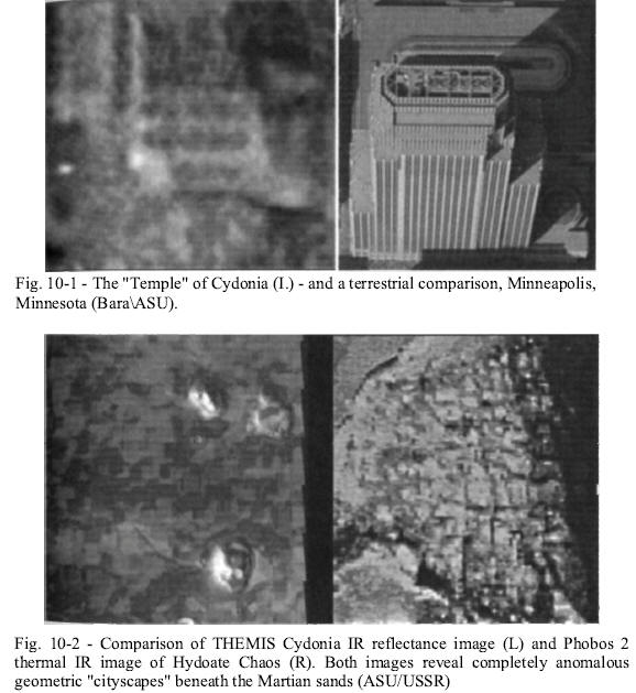
Phobos 2 IR image and the new Cydonia data [Fig. 10-2]. That did the
trick with Art on the images, but everybody still wanted proof of
who "Bamf was - so one of the authors (Bara) called him.
It took no time at all to find Noel Gorelick in the ASU phone
directory. Bara called him the afternoon of September 6, 2002. In
the course of the conversation, Gorelick freely admitted he was "Bamf,"
that he was responsible for all of the postings in the Enterprise
Mission BBS under that name, and he reiterated his stance that the
Cydonia IR image page had been untouched since he posted it on July
24, 2002.
Bara then went on Coast to Coast AM that night to pass
this information on.135
To some extent, these accusations and this sort of behavior were to
be expected from the "usual suspects" on the various message boards.
What we weren't prepared for, however, was an assault on our
integrity from a former friend, especially one who should have known
better.
Stretching the Truth
Shortly before we published our revelation of the existence of two
THEMIS Cydonia IR images, on August 29, 2002, SPSR's Dr. Mark Carlotto put out his own analysis of the Cydonia multispectral
image.
From the beginning, we were concerned about the contents of
the Carlotto analysis. For one thing, there were simple errors (for
instance, the IR image is referred to as "E0201847.gif," which is
the wrong file name for the multispectral Cydonia image,
"20020724A").
In addition, there were numerous misspellings and
other obvious mistakes-which gave the whole project an air of haste
and sloppiness. It did not seem to be up to Carlotto's usual
thorough standards - at least as Hoagland had remembered them from
working with Carlotto years before.
As we got into the content of the article, it seemed to stray into
even odder territory. Carlotto started out by comparing the Odyssey
Martian THEMIS data to terrestrial Landsat images, a very inaccurate
comparison to say the least.
Landsat is a 1970s-era technology that
produces primarily surface reflectance data in the visible region of
the spectrum, as compared to THEMIS, which concentrates on
extracting data primarily from intrinsic thermal infrared emissions
from surfaces and objects. Landsat, in contrast to THEMIS, has
virtually no "ground penetration" capabilities at all.
A far better
comparison would have been made to a relatively new Earth orbiting
instrument (1999) called ASTER (Advanced Spaceborne Thermal Emission
and Reflection), which has very similar near-infrared capabilities
to THEMIS.
Carlotto went on to make some even stranger "errors" in his article.
He proceeded to conclude that there were various clays making up the
composition of the region surrounding the Face. However, Carlotto
surely must have known that he could make no such conclusions, since
the calibration data for either the official version or the "real"
version of the Cydonia IR data had yet to be released. He also
failed to perform a decorrelation-stretch, a step that is crucial
for separating the thermal data from the composition information in
the image.
However, even if he had, it would have made no
difference, since without the crucial calibration data his
conclusions about the specific composition of Cydonia were
meaningless. Beyond that, he completely ignored the overwhelming
amount of noise in the official image and seemed more than satisfied
with the poor quality of it.
Even as we tried to make sense of Carlotto's seeming "brain fade,"
our attention was drawn to another recent item posted on his new
website.
In it, he directly addressed the issue we had raised
concerning the discrepancy between the two IR datasets, the
"official" and the "real" one obtained by Keith Laney. Carlotto
declared that clearly the "real" version we had posted was a
degraded version of the "official" one.
We knew this, of course, to be utterly laughable. In his analysis of
the two images, Carlotto had taken only a single unnamed band from
the "real" data, and compared it to a single unnamed band from the
"official" version.
He had not done a full composite of the "real"
image bands, not done any color ratios, nor performed a decorrelation-stretch to enhance the data. All he did was make a
simple visual inspection of two grayscale bands without performing
any of the accepted processes for enhancing false color thermal IR
data.
This, as we have said, is flatly not how you handle thermal IR data.
This is higher-order IR information, compared to a simple "pretty
picture." Even though it is lower resolution data, it is information
totally unavailable from even much higher resolution visual images.
Which is what makes lower resolution thermal IR THEMIS data such a
potential breakthrough on the thirty-year-plus Cydonia problem, even
at around 100 meters per pixel.
It is this fundamental fact of infrared optical physics that made us
believe from the beginning that Laney's July 25 "blurry" Cydonia IR
image was the "real deal," and the July 24, apparently much higher
resolution "official" image was, in fact, the "doctored" version.
The "real" image, while it may look a bit blurry, actually contains
far more data than the "official" version, no matter what the
"official" version looks like on first (naked eye) visual
inspection. That's why the processing and enhancement tools used for
multi-spectral (more than one band) imaging, to accomplish exactly
that, are crucial to extracting that "hidden" signal from this set
of IR images.
Carlotto, it seemed, was making the same elementary error that some
of our readers were making - assuming that sharper is automatically
better, as it is for visible light images. And curiously, he did not
do the other crucial steps, which would have instantly shown him
that the "real" (July 25) images contained far more, and far better
quality, data than the official version did.
This simple analysis in
and of itself would have immediately disproved his core hypothesis -
for how can "degraded" data produce quantitatively better results
(in a superb program like ENVI 3.5) under proper analysis, than its
supposed "source data," and with infinitely less noise?
The simple answer is that it can't - but that's not what really
bothered us What troubled us in the extreme was that Dr. Carlotto, a
world-class imaging expert, and DOD contractor on a host of
classified imaging analyses, should have known all this.
So, given this decidedly odd state of affairs - a well-known and
respected imaging specialist, who at least used to be curious about
Cydonia and suspicious of NASA, making not only a seemingly colossal
error in judgment, but compounding that error by failing to simply
put it to the test - we decided to consider our options.
The authors
and Keith Laney conferenced about Carlotto's article on the night of
September 3.
The general consensus was that Carlotto had effectively
"polished a turd" and declared that he discovered a pearl - all
without even considering the field of gems which had been placed
right in front of him.
Hoagland, however, refused to buy into the notion that Carlotto was
as incompetent as his analysis made it seem. He staunchly defended
Carlotto's skills and professionalism, insisting that there must be
some other reason for his reticence to properly process the THEMIS
images.
Considering Carlotto's membership in SPSR, we decided it was
possible that Carlotto had simply fallen in with the "honest but
stupid" crowd that forgives every NASA transgression, yet holds the
authors to much higher standards. The decision was taken to reach
out to Carlotto - if only to save him the embarrassment of a public
response pointing out his lack of thoroughness.
Bara subsequently
e-mailed Carlotto, informing him he'd made several errors in his
article, and advising him to pull it, at least until we published
our own analysis.
Carlotto responded via e-mail and pointed out that he had plenty of
experience working with thermal images, that the "real" image was
"obviously degraded, and that his paper had been peer reviewed (by
Dr. Horace Crater, a statistical analyst who has no working
experience we are aware of with thermal IR).
Mike's response back
was basically,
"suit yourself, but if we had peer reviewed your
paper, it would not be published right now."
Carlotto e-mailed Bara
back, got Hoagland's phone number, and the two men had a chat on
September 4.
According to Hoagland, what Carlotto seemed most concerned about was
that his previously published paper would be made obsolete by our
article-After a wide-ranging discussion, which included Carlotto
pointing out tha he'd written his own decorrelation-stretch
algorithm, Carlotto agreed to take the "real" image, perform all of
the proper steps (composite, color ratios and decorrelation-stretch)
on it, and either call or e-mail Hoagland with his results.
That
never happened.
We have no way of knowing if Carlotto ever did the analysis he
agreed to do, but after more than a week of waiting, Carlotto's only
response was to publish yet another "update," in which he dug
himself into an even deeper scientific and ethical hole.
Instead of following the proper protocols for processing thermal
infrared data as he'd agreed to do, Carlotto decided instead to take
the "official" version of the Cydonia THEMIS image and subject it to
a series of contrast and blur filters in an apparent attempt to
"prove" that the Laney image was generated by degrading the official
one.
He did this by taking only a single band image, not a
composite, and he of course did not do any of the other tests he
agreed to perform in his conversation with Hoagland. This led him to
conclude "its similarity to the top left ["real"] image strongly
suggests that the Enterprise image is an altered version of the ASU
image."
He then goes on to claim that because the Laney image changes from
band to band in the unratioed grayscale it is a "distorted" version
of the "official" ASU release. What is truly disturbing is that
Carlotto's "test" here is proving exactly the opposite of what he is
claiming. Real multispectral data (and certainly thermal IR data)
does change from band to band.
What he is illustrating is exactly
what true multispectral data should look like.
He's not seeing
distortion, but rather the expected shift in "return" to the camera
from slight variations in the thermal signatures of actual features
on the Cydonia plain.
The other phenomena he seems to be describing,
the "shift" in certain edges of some of the large features, is
simply due to the fact that the various bands are not all taken at
exactly the same time. There are significant shifts in the
spacecraft's position as different filtered CCDs in the THEMIS
camera record (in a rapid-fire sequence) of the actual imaging data
for all the bands. This makes it a near impossibility to simply
overlay the various bands when doing a composite.
Of course, had he
simply read the camera specs, he would have known this, and
physically corrected (as Laney has successfully) for the minute
geometric shifts.
That Carlotto made no effort to correct the alignment problem is not
only a testament to his lack of thoroughness in this case, but an
outright indictment of his methods and possibly even his
motivations. Keith Laney, at our request, produced an image similar
to the section that Carlotto had done, only with the various bands
properly aligned geometrically. It took him all of five minutes.
All Carlotto would have to do, if he truly wanted to decide the
question of which dataset is "degraded" and which is "pristine,"
would be to run the two images side by side through a quality
enhancement tool, like ENVI 3.5 as Keith had done. Had he done so -
as he promised Hoagland he would - he would have clearly seen that
he got it completely backwards.
What makes this truly egregious is that Carlotto certainly knows
everything we have described above, that a simple visual inspection
of a single grayscale IR band is not a valid comparison of these
incredibly information-rich datasets.
He has evidently decided that
it is better to try and cover his own mistakes by making up a
"pretty picture" which only proves his talents as an artist, not as
a scientist. What seems to have happened is that Carlotto is
unwilling to publicly face the fact that his initial declaration
"that the Laney image is the degraded one" is flat out wrong.
Given
the opportunity to admit his mistake, he has instead decided to
cover his tracks with this absurd comparison. We were truly sorry
that Carlotto had chosen to take a politically defensive stand,
instead of the scientifically courageous one.
The absurdity of this position is underscored by an e-mail Laney
received from Research Systems, Inc. While refusing to get into the
middle of the "which image is real" controversy, the communication
made several points totally inconsistent with Carlotto's "analysis."
Said Keith's RSI ENVI representative:
"I must admit, this has made quite a stir in the astronomy
community! At any rate the images look awesome! As I tell anyone who
asks about RSI's stance... 'RSI does not have an opinion either way,
we just want to provide the best software to scientists so that they
can do their own best work.'"
How could someone crudely "degrading" the official Cydonia data
create "quite a stir in the astronomy community?"
Given the
scientists that RSI routinely deals with, and their level of
multi-spectral expertise, any simple "degradation of the official
ASU THEMIS website image into the one Laney has been working with
(with RSI looking on) would most certainly have been caught if it
was as simple as Carlotto was now claiming. Also, if Keith's image
was a "hoax," why would the RSI representative go on record saying
that the images produced from it 'Took awesome?"
Wouldn't the better
part of valor be to simply refrain from all comment until the
lineage of the "real" image was determined?
In effect, Carlotto had simply parroted the position of Dr. Phillip
Christensen of ASU by declaring that the Laney data is "degraded,"
when all parties involved (as the RSI e-mail underscores) certainly
know that the official version is far inferior to the Laney data.
By
refusing to put that data to the true scientific test - whatever the
reason - Carlotto and SPSR are reduced to being nothing but
mouthpieces for the NASA party line. As we said before we released
this data, people were going to have to take sides... and SPSR and
Carlotto evidently had.
However, the attempt to bring Carlotto back into the fold was not
all wasted. A reader, Wil Faust, made a truly inspired suggestion to
us. Why not compare, he said, Carlotto's own seminal work - his
fractal analysis of the Cydonia region from the Viking data - to our
own IR results?
So we did.
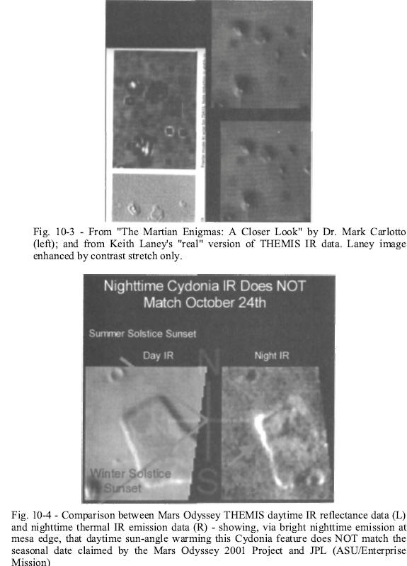
It turns out that when you use Carlotto's own methodology, and take
a single band of the IR image strip from Keith's "real" version of
the data to compare it against Carlotto's own fractal analysis of
Viking frames 35A72 and 70A13, you get quite striking results. Not
only are the THEMIS blocks - which Carlotto now flatly claims are
"enhancement" or "filtering" artifacts - clearly visible on his own
work from twelve years ago, but they match up very precisely with
the blocks on the Laney image, literarily one for one [Fig. 10-3].
It is now incumbent upon Dr. Carlotto, who is so sure that the Laney
image isn't valid (or is at least "degraded"; he'd parsed his words
pretty carefully) to demonstrate just how "filtering artifacts" can
not only line up with features in Odyssey's THEMIS and visible light
images - but also with direct non-fractal "hits" in his own dataset.
Significantly, these non-fractal patterns - to show up in the
visible images at all - also have to be caused by geometric
structures buried just beneath the ground. Clearly, Dr. Carlotto's
methods - which have led him to dismiss all of these converging
anomalies as just "degraded data" - had led him off the edge of the
paper.
It is one thing to make honest errors in a piece of scientific work.
It is quite another to compound those errors and miss the entire
forest by hiding behind an incompetent "peer review" and obvious
political propaganda, without even checking your own previously
published work.
We have no desire to pillory Carlotto any further here.
His own
demonstrable lack of true scientific curiosity has more than
accomplished that. We simply challenge him again in this volume - as
we did in 2002 - to produce and publish the composites, color ratios
and decorrelation-stretch results from the appropriate
multi-spectral analysis he promised Richard Hoagland he would do on
the "leaked" THEMIS image.
Until he does this, sadly, we can no
longer endorse his methods, his competence or even his intellectual
honesty on any issue pertaining to this continuing extraterrestrial
artifacts investigation.
Night and the City
As the summer of 2002 drifted into fall, we had just about run the
course on options over the IR data.
We still hoped for a legitimate
nighttime IR image, since that would provide far greater contrast
than the daytime image and should theoretically reveal the "buried
city" in even more dramatic relief than the "real" daytime IR had.
Just when we reached the point of giving up, however, it was Bamf to
the rescue. Shortly after our publication of an article highly
critical of the deceptive statements he had been making in our
online BBS,137 he finally delivered that which we had been asking
for - sort of.
On October 31, 2002 - Halloween no less, the same pagan holiday that
marked the ''birth" of JPL - ASU released what they alleged was a
nighttime infrared image of Cydonia. Not only did this image appear
on that most pagan of pagan ritual dates, but the caption claimed it
was taken just a few days before, October 24, 2002, the one year
anniversary of Odyssey's insertion into Mars' orbit.
These ritualistic manipulations aside, it was immediately clear that
there were issues with the data. Rather than the full nine bands as
we had been given in the daytime image of July 24-25, this time we
got a cropped image showing a portion of a single nighttime image
strip alongside a similar crop from (supposedly) the July daytime
image.
The official ASU caption read:
"This pair of THEMIS infrared images shows the so-called 'Face on
Mars landform viewed during both the day and night. The nighttime
THEMIS IR image was acquired on October 24, 2002; the daytime image
was originally released on July 24, 2002. Both images are of
THEMIS's ninth IR band (12.57 microns), and they have been
geometrically projected for image registration."
Yet a comparison with band nine from the actual July 24 release
revealed the first of some troubling discrepancies.
Band nine of the
July 24 daytime IR is listed on the original ASU graphic as being
"12.58 microns"; but on the October 31 comparison, it's cited as
"12.57 microns."
It turns out that depending on which official THEMIS document you reference, you get a different center wavelength
value for the infrared filter strips on the THEMIS camera CCDs. This
can be quite confusing, since it makes a difference in how IR bands
are subsequently processed.
Even more troubling than this perplexing "filter change" was a major
discrepancy in the new image itself. In the July 24 original, the
image "footprint" cuts off two mesas at the top of the scanned
strip; in the October 31 "version" of the same image, there is
clearly significantly more surface detail captured northeast of
those mesas. Two verifiably different image "footprints," for what
had been categorically maintained by NASA, ASU and JPL for months as
only one July 24 image.
Given the shrill accusations of "hoax" and "fraud" leveled at both
Keith Laney and the authors for even suggesting that there could be
two different versions of this image, the new posting was
vindication. The publication of two demonstrably different
"official" versions is elemental proof that we were right. It also
opens even more possibilities; if there are no less than two
"official" versions of the July 24 data, why not a third version
that matches Laney's "real" data?
That being said, what - if anything - was to be gained by taking
seriously the contents of this first nighttime Cydonia IR image -
THEMIS image number 20021031A? First of all, just looking at the
image, something was clearly wrong: the data itself is just too
"noisy" for a Martian summer image.
Even a casual comparison with a nighttime IR we'd seen previously
reveals that the noise level of this new nighttime Cydonia IR is
comparable to that image (101180002) which was taken in the dead of
Martian winter in the northern hemisphere, March 21, 2002. The
current Cydonia image, by contrast, was supposedly acquired October
24 - eight months later - just after the beginning of Martian summer
in the northern hemisphere.
So why was it so noisy? One basic reason could be that Bamf had
simply lied again.
The truth was that, yes, this was a nighttime Cydonia IR image, but it was taken (probably as one of a series of
unreleased Cydonia images) much earlier in the current Odyssey
Mission than publicly admitted - when it was simply a lot colder at
Cydonia. This effectively reduces contrast and increases noise.
After the publication of our latest article on October 20, 2002 Bamf
(and those managing his actions on the THEMIS team) hurriedly put
out something on nighttime Cydonia IR just to shut us up. So he
reached into the THEMIS "hidden Cydonia drawer" and pulled out an
older, "colder" (and partially sanitized) "new" image, which he then
simply labeled as one taken on October 24, 2002. At least, that was
our working theory. We now set out to prove it.
Because we know the latitude of Cydonia (about 41° N), and the tilt
of Mars on its own axis (about 25°), we can easily calculate - by
observing the details in the image, and comparing them to the
geometric position of the sun at any time of the Martian year - when
this image had to have been acquired.
Essentially, it's "Astronomy
101."
This is the simple equation that allows us to derive this crucial
geometric information:
sin D = sin a / (cos b)
Where D = max deviation (north or south) of the rising or setting
sun from an east/west line; a = planetary obliquity (its tilt); and
b = the latitude of the observer. "D" is also defined as the "summer
or winter solstice": i.e. the longest days of summer, or the
shortest days of winter, in that hemisphere.
Halfway between these two farthest excursions of the sun, north and
south along the horizon, is the geometric position of the "spring
and fall equinoxes." The word derives from the Latin, meaning "equal
night": i.e. the length of the days and nights at that position in
Mars' annual solar orbit (year) are approximately equal (Mars' orbit
being decidedly elliptical).
Applying this calculation to the new Cydonia image, we could derive
- with absolute scientific certainty - when this image had to have
been taken, and we didn't need to "trust".
We began with the orbits
of Mars and Earth.
Using a newly created "analog orbital computer,"
courtesy of Dr. Bob Zubrin, we were able to compare the two
planetary orbits and graphically convert from any date and season
here on Earth to its equivalent on Mars.138 By using this tool we
could confirm that Odyssey arrived in Mars orbit on October 24,
2001, just after the Martian winter solstice in the northern
hemisphere.
By then advancing the dates to correspond to Bamf s claim that the
new nighttime IR Cydonia image was taken on that one-year
anniversary - precisely twelve Earth months later, October 24,
2002-we could see that the new image would have been taken over Mars
just after the Martian summer solstice in the northern hemisphere.
Because he arranged both images - day and night - at the same but
opposite symbolic angle to the Martian equator in his graphic (about
7°), it's a simple matter to match the illumination of the features
seen in the images with the true Martian coordinates - and compare
that with the calculated sun angles for any particular Martian
season derived from the equation cited earlier.
When we overlaid (within an error of +/-3°) the calculated angle of
for the maximum summer and minimum winter illumination angles
(solstices) to an east/west line (which determines the angles at
which slopes receive the last rays of the setting sun, and thus
which will be warmest throughout the night) - a very interesting
picture regarding when this nighttime IR image was actually taken
begins to emerge.
In the "natural model," the only source of energy to warm the
Martian surface is solar illumination.
For objects on that surface
to "glow" in the thermal infrared at night and be detectable by the THEMIS camera, therefore, requires that they be dense enough to
retain a significant amount of solar energy for hours after sunset
and be angled essentially "face on" towards those last warming rays
of the setting sun.
If we examine the nighttime Cydonia landscape Bamf had now given us,
several intriguing aspects of this model nicely come together. Apart
from the Face, there is another distinctive feature at Cydonia, "the
island."
It's a roughly rectangular mesa, several miles due east of
the Face, with a flat surface area of several square miles -
standing a few hundred feet above the surrounding plane. Its two
western, relatively steep vertical cliffs face northwest and
southwest roughly in the directions of the summer and winter
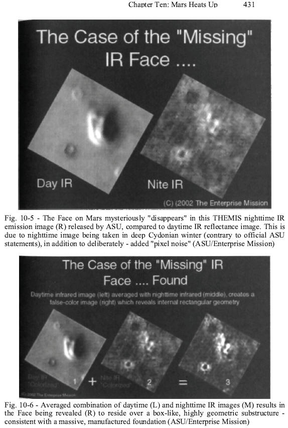
solstice sunset points [Fig. 10-4].
Examination of the "daytime thermal image" [Fig. 10-4, left] clearly
shows the afternoon sun coming from the southwest, casting distinct
cold shadows off the mesa's northeastern cliff (dark band, upper
right). The top, northwestern cliff [Fig 10-4, dark band, upper
right), though illuminated, is almost as dark as the shadowed
eastern cliff, indicating that sunlight is reaching it at "grazing
incidence."
There's also a distinct (colder) "darkening" extending
back from the western "tip" along this northwestern cliff,
indicating an "outcropping" at the tip, creating a distinct (thus
colder) shadow extending about a mile.
Even though Bamf claimed (on the BBS and also in several private
e-mails to some members) that this image was taken on May 5, one can
confidently state from this solar geometry (mathematically
extrapolated to the sunset point), that the July 24 image had to
have been taken approximately halfway between the northern Martian
hemisphere winter solstice (just before Mars Odyssey arrived,
October 24) and the Martian spring equinox. In other words, on
Earth, sometime in January 2002... not May 5.
Coincidentally, this was the precise timeframe of the final
"tweaking" of Odyssey's Mars orbit (after aerobraking), which was
advertised as a means to achieve the final mapping orbit for the
formal science mission, which was to begin on February 18, 2002.
If Cydonia was (and is) a "hidden priority" for this entire mission
- as certain official Odyssey mission press statements, the released
Cydonia imaging data, and "Bamf s" own still-inexplicable,
summer-long disinformation campaign on nighttime infrared
capabilities at Cydonia all strongly suggest - January 2002 would
have been the perfect time to take the image.
While adjusting the
orbit of the spacecraft for the main science mission, some "trims"
could be included that would allow Cydonia to be quietly imaged very
early in the mission. In fact, it could have been done even before
the formal mapping mission (and unwanted press attention) began.
So what about Bamf's claim - that the nighttime Cydonia IR image was
acquired on October 24, 2002?
In the right hand portion of Fig. 10-4, if you look carefully at
this enlargement of the nighttime image you will notice that the
brightest "thermally glowing" cliffs are once again facing west,
toward the setting sun. This critical geometry is simply due to that
being the last input of solar energy to these exposed rocks, before
the onset of the frigid Martian night.
Remarkably, for when this image was supposedly taken, the most
heated portion of "the island's" cliffs in this nighttime shot is
the southwestern section and only a very small portion (that
previously described "outcropping") of the northwestern-facing
cliff.
If the sun were anywhere near the northern Martian summer solstice
October 24, 2002, when this image was acquired, this entire
northwestern cliff would have been directly heated by the setting
sun and brilliantly glowing after sunset. And it is not.
From this simple (but irrefutable) solar geometry, the truth behind
this image is now obvious. THEMIS image 2002103 lA-the nighttime IR
image of Cydonia-could not have been acquired on October 24, 2002.
The only time, according to this solstice geometry (lower green
arrow) in the entire Odyssey mission this Cydonia image could have
been taken, was in the same timeframe as the July 24 daytime IR
image release, sometime in January 2002.
This now also explains the other, totally inexplicable discrepancy
about this image - the nighttime Cydonia surface temperatures,
reportedly recorded at the "height" of Martian summer.
In another March 21, near-Cydonia nighttime IR image (101180002),
the temperature range - from the coldest region in the image to the
"warmest" - was cited in the Planetary Data System as "-56°
Centigrade to -40° Centigrade" - a spread of about 16° C.
This image
was taken during the shortest period of Martian daylight, and on one
of the coldest, longest nights around the northern winter solstice,
and only about a hundred miles east of Cydonia itself.
By sharp contrast, the official caption for the "October 24"
nighttime Cydonia image - taken at the same latitude and in the same
geologic province and (ostensibly) just after the northern summer
solstice - mysteriously reports much colder nighttime
temperatures.139
According to the official ASU October 31 release:
"The temperature in the daytime
scene ranges from -50 ° C (darkest) to -15 ° C (brightest). At
night many of the hills and knobs in this region are difficult
to detect because the effects of heating and shadowing on the
slopes are no longer present. The temperatures at night vary
from approximately -90° C (darkest) to -7° C (warmest)..."
Let's get this straight:
The coldest reading (-56° C) in the
nighttime March 21 winter image was only 6° colder than the coldest
daytime temperature (-50° C) in the "July 24" image - but the lowest
surface temperature in the nighttime "October 24 image" (-90° C),
taken near the summer solstice, was 46° colder than the coldest
winter temperature on that March 21 image - and the highest
temperature recorded in that new nighttime Cydonia image (-75° C) -
again, reportedly taken at the height of the Martian summer - was
35° C colder than the peak nighttime winter temperature (-40° C),
measured in that nearby March 21 winter nighttime image... huh?
Why are the readings taken on a "balmy Martian summer night,"
compared to the dead-of-winter nighttime readings taken just across
the hill, so much (impossibly) colder?
Unless they're not really "summer" nighttime readings at all,
because
Bamf (if not the entire THEMIS team behind him, from Christensen on
down) just blatantly lied to us... again.
That's what the objective
science in these images now tells us - and from two totally
independent disciplines, planetary orbital geometry and THEMIS' own
radiometry of Mars.
Having satisfied ourselves that this new Cydonia data had been
deliberately withheld, probably because it contained some critical
new corroborative information on the "intelligence hypothesis"
(otherwise, why bother to conceal it at all, and for so long?) we
can now move on to consider what genuine anomalies might lie hidden
here, even in this "sanitized" version of the latest "trick or
treat." Remember - in order to be believed, some "truth" must be
continually mixed in with all the lies.
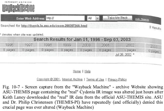
The most striking "Cydonia anomaly" in the newest NASA/JPL/ASU
release is the almost complete "disappearance" of the Face. In a
side-by-side presentation, the Face - as seen in the July 24 daytime
IR image (left), compared with its nighttime "October 31"
counterpart (right), is almost completely missing [Fig. 10-5].
Remember, these are thermal IR scans. What we are seeing - in both
the day and nighttime THEMIS images - is infrared radiation due to
solar energy, being reflected back and/or emitted from the
sun-warmed Martian surface.
In the afternoon close-up, the THEMIS camera is recording reflected
longwave solar energy (thus shadowed surfaces are extremely dark and
cold), as well as re-emitted thermal radiation from the exposed
sunlit portions of the "mesa," externally heated by absorbed
radiation from the sun. In the nighttime image (right), the only
radiation being picked up by the Odyssey camera is this re-radiating
stored solar energy (this, of course, in NASA's "externally warmed,
natural" model).
This being the essential physics of these images, why is the
nighttime close-up of the Face, compared to its daytime counterpart,
of such obvious lower quality and resolution?
Part of the reason, we
now know, is due to the fact that the image was taken much earlier
than Bamf let on in his extensive BBS conversations. This image was
taken literally at the coldest period of northern Martian winter -
some time in January 2002. The frigid ground temperatures reported
in its official caption, -90° C to -75° C, quietly confirm this,
even if we didn't have the seasonal lighting geometry to cinch it.
In such a bitterly cold environment - and at night - the solar
energy absorbed during the day, even by materials capable of
efficiently retaining such solar radiation, is going to be
relatively weak. So we would expect a nighttime IR "signature" to be
significantly noisy if the image was actually taken in January 2002
(as we've now proven).
On the other hand, when we examined the pixel details of this
nighttime Cydonia IR image, it was also obvious that "someone"
carefully "added" a significant amount of noise in an obvious effort
to obscure certain geometric patterns that were recorded.
Fortunately, knowing this, it is possible to significantly reduce
their final impact and amplify the real geometric patterns.
In fact,
in the official presentation of this data by the THEMIS team there
are "coded" instructions in the caption for precisely what to do:
"Both images are of THEMIS's ninth IR
band (12.57 microns), and they have been geometrically projected
for image registration."
In other words, place one image precisely over the other ("image
registration"), as that (as every astronomer, physicist and imaging
specialist knows) will significantly reduce the "noise."
Which, of course, we would have done anyway.
But Bamf s careful
preparation of both images, already precisely scaled and tilted by
the appropriate amounts, made it far easier to carry out. Keith
Laney prepared an "averaged" version of both images in a couple of
minutes, thanks to Bamf s "helpful" presentation [Fig. 10-6].
The Face immediately pops out [Fig. 10-6, top, center], as well as a
number of other, highly intriguing thermal anomalies across the
image.
The Face is revealed in the nighttime IR to be a perfectly
rectangular "box," with lots of internal rectilinear geometry
inside. Even in a simple contrast-adjusted and "Gaussian blurred"
version of the "raw" image the striking geometric lineaments are
plainly visible, as are the "squared off proportions matching the
daytime image.
One intriguing feature that appears in the nighttime version, but
does not appear in the daytime image, is the "symmetrical extension"
below the "chin." Clearly, something close to the surface, but
underground, is warm enough in the nighttime IR to allow its heat to
"leak" up through the overlying layers of sand and dust and reveal
its symmetrical presence underground.
The brightest (warmest) sections of the Face are clearly those
highest on the feature - the left "eyebrow ridge" and the "nose" -
consistent with their retaining the most heat from being exposed the
longest to the last rays of the setting sun.
The rest of the
mile-long "mesa" - remarkably, for a "rocky, eroded outcrop" - has
almost blended into the very frigid Martian surface, clearly having
cooled off very fast after sunset.
Interestingly, in the author's foreword to the fifth edition of The
Monuments of Mars, Hoagland had predicted months previously
precisely what we were now seeing in this latest nighttime image:
"The [Mars Odyssey] camera's
long-wavelength ability to sense and image subtle temperature
differences... will allow detection of cooler geometric
artificial structures against the warmer natural background
deserts (especially at night), the same way suspended bridges
and skyscrapers on Earth cool first, before surrounding
landscapes."
In addition to the highly anomalous internal geometric structure of
the Face, which now strongly reinforces the non-natural, constructed
model, the unnatural coldness of this structure must also be
addressed.
Why is the whole of the Face so cold compared to the
surrounding background if it's just a "naturally eroding mesa?"
One obvious answer is that it's not a "natural mesa" at all - that
the Face, as we've suspected all along, is composed of other types
of manufactured materials and in a form that quickly allows the
daytime heating from the sun to be dissipated after sunset.
This
requirement would be satisfied if the composition were some kind of
"conducting material" like a metal, and if this material was
significantly porous (perhaps "honeycombed," thus allowing very
efficient night air cooling) to boot.
Clearly, something is definitely "anomalous" with this one feature,
at least regarding the nighttime thermal properties of its external
surface, which is precisely what we were expecting - if it's
artificial.
Close-ups of other "average mesas" on this landscape -
some of which are, like the Face, located precisely according to the
unique "hyperdimensional geometry" that's overwhelmingly "coded"
here - also seem to be exhibiting "anomalous" thermal properties.
Anomalous, that is, for mere outcroppings of erosively resistant
rocks.
Is this why this image was apparently one of the first clandestinely
acquired by the Odyssey mission, even before any other science was
begun - and at literally the coldest period of the northern Martian
winter, the best time to determine (with the low-noise thermal
background) if "the lights were still on" somewhere at Cydonia?
Is this why the image Keith Laney was leaked on July 25, 2002 bears
an eerie resemblance, as if it was a combination of a high quality
daytime IR overlaid on another nighttime image? Is this why the D&M
in Laney's multi-band version of the NASA July 25 image has this
astonishing "transparent aspect," because it's a much more
noise-free (averaged) version of what we've been discussing?
The only logical conclusion one can reach regarding this whole
elaborate charade is that someone went to a lot of trouble to
conceal something critical regarding this entire, early focus of the
Odyssey mission on Cydonia, and on this nighttime image.
And, as always, there was more to the story. A few weeks after
publication of a story on the nighttime IR on the Enterprise Mission
website, Gorelick got involved in an online chat about it on the
MarsNews.com forum.
In the course of the chat, he was asked why he
only posted a single band of the nighttime IR, instead of the full
nine bands as they had with the daytime (both "real" and "official"
versions).
Bamf replied that,
"I could do a nine-band IOTD like the
7/24 image, but since we've already done of it [sicj, I don't think
we'll do another one."
The implications of Gorelick's off-the-cuff and arrogant remark were
telling.
Did he really mean to publicly imply that THEMIS has
acquired all nine bands of nighttime infrared across Cydonia - in
addition to the one he'd deigned to publish? His statement cannot
really be interpreted in any other way. Gorelick couldn't tease us
with his "I could do a nine-band IOTD..." unless the spacecraft had
in fact acquired all of them.
And that brought with it some major
political implications.
A random check of about fifty (of the approximately two hundred
nighttime) images then displayed on the ASU THEMIS archive website
revealed only one other image which was acquired with all nine bands
in the entire THEMIS library. If carried through, this is a rate of
only two percent.
In other words, if Bamf was telling the truth in his online chat, a
nine-band data set of nighttime Cydonia IR, according to ASU's own
records, represents an almost singular occurrence in terms of other
nighttime images of Mars.
Clearly, acquiring a full nine-band nighttime IR - of a region that
has repeatedly been termed "scientifically uninteresting" by the
entire THEMIS team - can only be additional corroboration of the
clandestine nature of the Odyssey mission from the beginning. It is
also further confirmation as to why there have been so many
systematic lies even about when images are being taken of Cydonia.
"Someone" is truly scientifically obsessed with the IR composition
of Cydonia and was doing all they could to hide that increasingly
obvious obsession.
So, did Bamf truly "slip" in revealing this new gem? Or was this
another in an increasing number of fortuitously timed, carefully
thought-out revelations about what was truly going on inside the
Mission?
We decided, frankly, that we were no longer willing to speculate or
wait for Christensen and his team to drop us another coded nugget.
It was time to go on the offensive.
Caltech
In early 2003, most of the nation was trying to cope with the
national tragedy surrounding the demise of the Space Shuttle
Columbia.
While there was a great deal about the disaster that made
it look suspicious, there was equal weight to the arguments that it
had simply been a terrible accident. Investigations revealed that
NASA, in an effort to appease the Clinton administration's EPA, had
switched to an "environmentally friendly" external tank insulating
foam in 1996, and had been having trouble with it ever since.
Once
that decision was taken, it was only a matter of time before a Columbialike disaster would befall the agency. We could not devote
too much time to Columbia because, frankly, we were knee-deep in
Mars.
In the spring of 2003, NASA released a new five-band color image of
the Face on Mars. The image had the same date stamp as the nighttime
Cydonia infrared image that was released the previous year. This
immediately raised our suspicions. We had already proven that the
nighttime Cydonia infrared image was not taken on October 24, 2002,
as NASA claimed.
That meant we could not be sure about this new
five-band color image either - and, almost immediately, there were
new questions raised about the visual light image.
This would have to wait for more detailed investigation, however. We
had discovered that both Michael Malin and Phil Christensen would be
attending a public event at JPL's sixth international Mars
conference in Pasadena. We felt like this would give us a great
opportunity to confront Christensen about the daytime infrared image
that had caused so much controversy the previous year. So on July
23, 2003, Mike Bara dutifully attended the public event.
Both Dr. Malin and Dr. Christensen gave slideshow presentations.
Christensen
could not resist showing the recent five-band color image of the
Face on Mars. As he brought the image of the Face up on the screen,
he smirked and asked the audience if they knew what it was. There
was a nervous chuckle throughout the crowd.
He then put forth a new
idea about the natural geologic evolution of the Face. He suggested
that the unusually bright reflectivity of the eastern side of the
Face mesa was because of an accumulation of carbon dioxide snow on
that side of the Face. He smirked once again when he asked the
audience if they had any comments on his idea (there were none).
However, a few moments later, when Dr. Arden Albee opened the forum
for public questions, the smirk was wiped off his face.
As no one stepped to the microphone initially, Bara decided to ask a
question. Dr. Albee suggested that the person asking the question
give their name. When Bara approached the microphone and gave his
name: "Michael Bara," Dr. Malin audibly groaned and proceeded to
hide behind a stage curtain. Malin emerged from behind the curtain
only after hearing that the question was for Dr. Christensen.
Christensen himself became highly agitated. He began pacing back and
forth across the stage as Bara asked him if the original Cydonia
daytime infrared image, which was posted on the ASU website on July
24, 2002 had ever been changed. At one point as he stumbled for an
answer, Christensen dropped the battery pack for his wireless
microphone and had to scramble to pick it up.
Obviously, he was
surprised and caught off-guard by this confrontation. When he did
answer, it was in a nervous and halting tone, and he only
occasionally made eye contact with his questioner.
Christensen defended the data on the THEMIS website. He claimed that
once it had been posted on July 24, 2002 it had never been altered.
He also went on to state that he had no idea how the "artificial
stuff had gotten on the images that Keith Laney had processed. At no
time did he say that the Laney version of the image was an outright
fake, nor did he accuse Hoagland, Laney or Bara of creating false
data.
His choice of the words "artificial stuff was quite telling,
because he could have just as easily used the word "fake." He
pointedly did not.
Just to be sure, Bara asked for clarification on the most crucial
point: had the data that was posted on the ASU THEMIS website been
changed after July 24, 2002? Christensen again emphatically answered
"no." What he did not know at that time was that at precisely that
moment, we had him.
Unbeknownst to Christensen, there is a website called the "Internet
Archive" (archive.org). Sponsored by the Library of Congress, its
purpose is to document every page that has ever existed on the World
Wide Web.
Using
a search engine called the "Wayback Machine," we had been able to
plug in the URL of the daytime Cydonia infrared image.
It had shown
that, contrary to Christensen's previous email statements and
contrary to his latest public statements, the ASU website containing
the image created and managed by Christensen's lieutenant Noel Gorelick had been originally posted on July 24, 2002, and had
subsequently been altered in the early morning hours of July 26,
2002 [Fig. 10-7].
As you'll recall from the previous chapter, Laney
downloaded the "real" version of the Cydonia daytime IR late in the
evening (10:27 p.m.) on the twenty-fifth. In other words, just hours
after Keith Laney had downloaded the "real data" from the THEMIS
website, Gorelick, Christensen or someone else had changed the
contents of the site.
So, all of Christensen's protestations to the contrary, there had
been at least one change to the Cydonia infrared image website after
Keith Laney had downloaded the "real" data. Within a few months of
our obtaining the Wayback Machine data on the Cydonia IR page, the
Internet Archive ceased tracking changes to any of the THEMIS ASU
image release pages.
This can only be done at the request of the
website owner, who in this case would have been Noel Gorelick. So it
was clear we would not be trapping Christensen or Gorelick in any
more lies anytime soon.
It was hard to tell from Christensen's reaction whether he was so
nervous because he was afraid he was going to get caught in a lie by
us, or whether he was under some pressure from outside forces to
keep the story straight even after this encounter. We're still not
certain whether Christensen is a friend or an enemy of our
independent investigation.
On the one hand he has given us the data
to prove our thesis beyond any reasonable doubt.
On the other hand,
he has participated (at least tacitly) in an attempt to discredit
our investigation publicly by spreading false information and data
to the public. Yet still, he had gone to some lengths to avoid
accusing us of faking the "real" IR data.
So in the end, we simply didn't have enough information to reach a
conclusion about Christensen the man, but we did have the new
five-band color image of the Face, and that would prove to be
perhaps the most significant piece of data we have received in the
entire history of the investigation.
Chapter Ten Images
Back to Contents
|