|

by Richard St-Laurent
6 June 2010
from
Yowusa Website
Spanish version
A heated debate in the
Planet X
community focuses on where Planet X is approaching from. Many
believe it is near or moving along
the ecliptic in the direction of
the sun (the plane of our solar system.)
Others such as ourselves, have always maintained that it is
approaching from the South.
Those who believe it is moving near or
along the ecliptic in the direction of the sun, offer in evidence,
cell phone photos and spurious SOHO image anomalies.
Our position has always been that this dubious imagery misses one
simple point. If so, Planet X which most likely has its own magnetic
field, would already be interacting violently with our sun, which is
at this time so quiescent, that NASA even said that it is the “quiet
before the storm.”
On the other hand, the only evidence that NASA is interacting with
our Sun is found in the data reported by the ESA-NASA
Ulysses Probe.
YOWUSA.COM, 13-October-08
The ESA-NASA Ulysses Probe
and Planet X / Nibiru
origin
The published
findings of the 2007, ESA-NASA Ulysses robotic probe's look-up
fly-under of the Sun's South Pole region came to our attention
while authoring our book, Planet X Forecast and 2012 Survival
Guide in 2007.
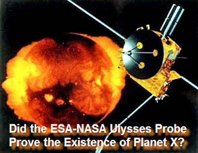
The ESA-NASA Ulysses Probe and Planet X /
Nibiru
It offered the first half of a
picture that would either provide proof of, or call into
question, the existence of Planet X. A possible acid test, so to
speak.
However, the second half of this picture would not arrive
until 2008, during the probe's scheduled look-down fly-over of
the Sun's North Pole region.
The last polar flyover of the probe was
“officially” unsuccessful though European sources indicate
otherwise.
Nonetheless, the data NASA did publish
clearly shows that the Southern hemisphere of the sun is
significantly more active than the Northern hemisphere, which
supports the argument that Planet X is currently approaching the
core of our system from deep within the Southern skies of our solar
system.
Published in 2008, these findings are now supported by new findings
that not only corroborates the Ulysses probe findings, but also
suggests a causality link between recent Earth changes, seismic
events, volcanism and even the BP oil spill and the approach of
Planet X from the South.
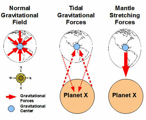
Mantle Stretching
If the earth is subject to a gravitational pull from below the
ecliptic (from the South Pole), this would theoretically make the
South Pole "inflate out" (ocean and continent rising) and the North
Pole crustal layers slide and stretch from one to another (mantle
stretching and following the earth's circumference path.)

Planet X
Gravitational Influences
If this is true, it would lead to
unusual weather and other types of anomalous patterns, such as
unexpected tidal behavior.
Have scientists noticed such phenomena? The answer, here again, is a
very resounding yes!
Scientists from different parts of the world
have recently verified these occurrences.
Wired.com, 24-Dec-2009
Tidal Forces Trigger Tremors
on San Andreas Fault
origin
The subtle changes in stress caused by tides in
Earth’s crust can trigger small, deep quakes along a seismically
active portion of California’s San Andreas fault, a new analysis
suggests.
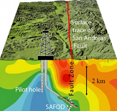
San Andreas Fault
The same forces of attraction that
cause ocean tides also cause tides in Earth’s rocks, says Amanda
Thomas, a seismologist at the University of California,
Berkeley.
And although the continual
variations in rock stress associated with those tides are
minuscule, they apparently are big enough to trigger small
tremors along some faults, Thomas and Berkeley colleagues Robert
M. Nadeau and Roland Bürgmann report in the Dec. 24/31 Nature.
This 2009 article documents the new
discovery that tides are not just ocean events, but crustal as well.
This discovery likewise highlights the
current risk of a major quake for the greater Los Angeles area.
YOWUSA.COM, 25-May-10
2010 Quake Prediction for the
Greater Los Angeles Area
origin
For those of you
living in the greater Los Angeles, CA area, an immediate and
prudent review your earthquake preparedness measures is strongly
advised.
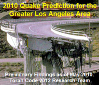
2010 Quake Prediction for the Greater Los Angeles Area
This article presents late-breaking
Torah Codes by film producer and research Richard Shaw, with the
permission of the research team in Jerusalem.
Please note, this
is not a call to panic. It is a call for diligent concern and
responsible action.
Is this new potential threat of a major
seismic event in Southern California related to the BP oil spill
that is now devastating multiple ecosystems along the Gulf Coast and
beyond?
Perhaps so, assuming there is a single
common causality as described in below video:
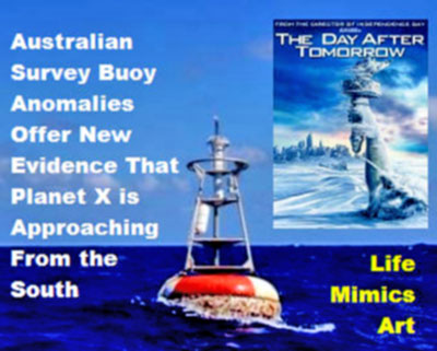
As you read the following analysis of the Australian survey
buoy anomalies, you may begin to see a correlation between
Earth
changes and
the BP oil spill and worse.
Perhaps this, more than the spill itself, motivated President Obama
has placed a moratorium on deep water drilling in the Gulf.
Why? Because a part of planet that we know less about than the face
of the Moon is changing and these changes are startlingly evident in
Australia.
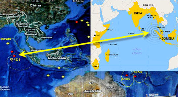
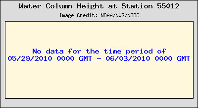
Buoy 53401
In April 2010 when
NOAA survey buoy 53401 started emitting alarming
data and sounded a state of "tsunami emergency," reporting major
seabed changes (the seabed rising about 300 feet) in the Indian
Ocean near Malaysia (located northwest of Australia.)
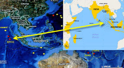
Buoy 53401 Location
The buoy transmitted data showing daily
major seabed changes from April 5 through April 12, 2010, and then
it was turned off or stopped sending data. The buoy was not
transmitting any information as of May 31, 2010.
At first, researchers thought the buoy was malfunctioning because
major seabed depth changes like this seemed impossible.
A Pattern Emerges
By itself, buoy 53401 was a singular anomaly.
However, the situation became more
serious and suspicious in mid-March 2010 when another buoy, buoy
55012, began emitting alarming data that showed dramatic changes in
the seabed depth and went into a state of “tsunami emergency.”
This
time, the buoy was located northeast of Australia.
Some days after that, a third buoy went into a state of "tsunami
emergency" when reporting, like the two first tsunami buoy stations,
tremendous changes in seabed depth in an area close to the second
buoy northeast of Australia.
The data showed a seabed rise of 13 feet
per day and was officially reported in the news on May 16, 2010.
Immediately following that report, the data streams for buoys 53401
and 55012 were halted.

So far, the dimensions of this story,
begin with the 24-Dec-2009 report that the
San Andreas fault in
California is susceptible to,
“the same forces of attraction that
cause ocean tides also cause tides in Earth’s rocks.”
Then a mysterious shut out of data feeds
for two key, Australian survey buoys following a report of a seabed
rise of 13 feet per day.
Is there another dot to connect? Yes!
Unexpected Changes
Under Alaska
On May 19, 2010, "Discovery News” reported that major and unexpected
changes in the earth's mantle under Alaska were found more or less
by accident during a scientific study in this area.
Discovery.com, May 19, 2010
Earth's Mantle in Overdrive
Under Alaska
origin
A new 3-D model of the
mega-quake and tsunami-launching duction zone in Alaska has
uncovered a big surprise: The
Earth's mantle there is moving a
whopping 20 to 30 times faster than
the crust.
So instead of being dragged along for the ride as a slab of
crust is pushed under another, the solid rock mantle rock is
swirling around the plunging slab like water around a paddle
dipped in a stream.
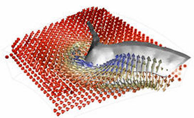
Earth's Mantle in Overdrive Under
Alaska
What the models predict are flows up
to 90 centimeters per year around the descending slab of crust,
said geologist Magali Billen of the University of California at
Davis.
Billen co-authored a report on the new model with former
graduate student and lead author Margarete Jadamec in this
week's issue of the journal Nature.
"On plate tectonics timescales that's screaming fast," said
Billen.
More typical plate speeds range from one to 10 centimeters per
year.
When these “earth changes” in the
Australian and Alaskan areas are added to other earth-change
anomalies like coal mine explosions that suddenly seem to occur all
around the world, the picture is no longer a disjointed collection
of coincidences.
There is something much bigger happening
and scientists are concerned.
Magma Rising
Recent seismic and volcanic events indicate a new and recent
worldwide magma rising, more accurately called a “magma plume,” that
accounts for the weather changes everywhere in the world including
the recent volcanic activity.
This begs an important question:
Could this be caused by a
gravitational pull from below the ecliptic?
Since the earth is subject to major seabed and continental shelf
changes, this would lead to many worldwide problems similar to the
hurricanes and volcanic activity we are experiencing presently.
But
if all this is real, it would again beg the question:
Is the earth
under the influence of a gravitational force field from below the
ecliptic?
The data is piling up with a simple answer.
A very alarming and
resounding yes!
|