|
PART 8 - EASTER ISLAND SYNCHRONICITY
|
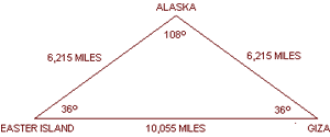
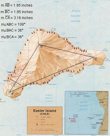
The three volcanic peaks
on Easter Island form an isosceles triangle with base
angles of 36°.
The relationship between the length of the base of
this triangle and the lengths of the sides precisely expresses
phi:
1.95 x 1.618 = 3.16
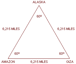
The Great Pyramid is
10,055 miles from the Southwestern volcanic peak on Easter Island.
A
triangle formed by the great circle distances between Easter Island,
the Great Pyramid, and the axis point for the line of ancient sites
in S. E. Alaska, has the same angular dimensions as the triangle
formed by the volcanic peaks on Easter Island, and also precisely
expresses phi:
6, 215 x 1.618 = 10,055
|
 |
|
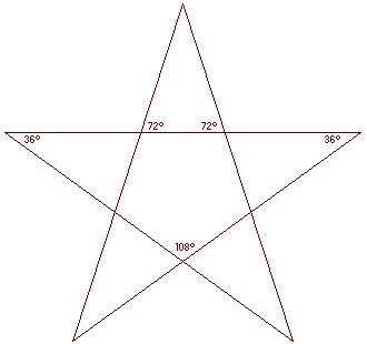 |
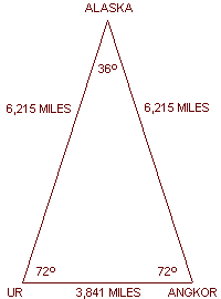
The large triangles in
five pointed stars have these same angular dimensions, and express
the same phi relationship.
All of the angles in five
pointed stars, 36°, 72° and 108°, are numbers that have been
associated with the precession of the equinoxes, as
well as the internal designs of the Great Pyramid and
other ancient sites around the world.
There are 72 major monuments at Angkor, 108
stone figures surround
Angkor Thom, and the highest terraces of Angkor Thom
house 72 Buddhas in latticework stupas.
|
The great circle distances between Angkor Thom, the ziggurat at Ur, and the axis point of the line of ancient
sites, forms an isosceles triangle with base angles of 72°.
The small triangles in five pointed stars have these same angular
dimensions, also precisely expressing
phi:
3,841 x 1.618 = 6,215.
These relationships are also clearly demonstrated by the metric
system, which is based on a distance of 10,000 kilometers from the
North Pole
to the Equator. The distance from Easter Island
to the
Great Pyramid
is 16,180 kilometers and the distance from Ur to
Angkor is 6,180 kilometers:
6,180 x 1.618 = 10,000.
10,000 x 1.618 = 16,180.
Back to Contents
PART 9 - WHERE IN THE RAINFOREST
After the discovery of America by Europeans, there were early reports
an abandoned city of megalithic stone construction in the Amazon
rainforest.
The legendary golden city of El Dorado was
also believed to be hidden under the rainforest. Explorers such as
Percy Fawcett and
Sir Walter Raleigh have searched for these sites, but their location(s) remain unknown.
|
Along the line of ancient
sites, the great circle distance from the
Great Pyramid to 4° 10' South Latitude, 56° 19'
West Longitude, is 6,215 miles (exactly 25% of the circumference of
the Earth).
The distance from these
sites to the axis point in Southeast Alaska is also 6,215 miles,
forming a perfect equilateral triangle.
As the line of ancient sites goes around the Earth, the azimuth, or
compass bearing, of the line changes.
It is interesting to note
that at 4° 10' S, 56° 19' W, the azimuth of the line of
ancient sites is precisely 60° (the angle between the line of
ancient sites going in the direction of the Great Pyramid,
and a vertical line of longitude going North).
|
 |
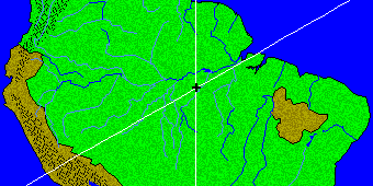
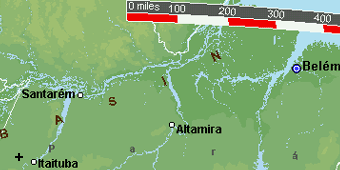
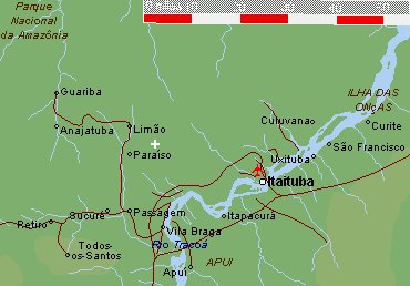
The Amazon Basin has
been mapped by satellite photography, but most areas are hidden
under the rainforest.
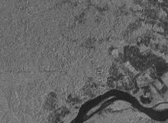
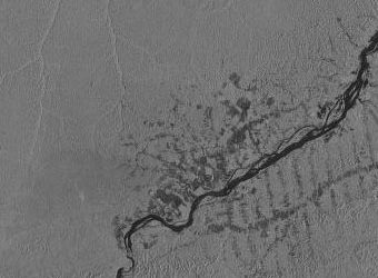
These are satellite
images of
Itaituba and 4° 10' S, 56° 19' W.
The image on the right is a
4x magnification.
The dark areas on the images are areas where the
forest has been cleared around Itaituba.
|
 |
During construction of
the Transamazon highway, significant gold deposits were discovered
near Itaituba.
There are numerous
caverns with drawings over 8,300 years old in this area,
including caverns along the line of ancient sites near Paraiso
and Itaituba.
If the special triangular relationships between the axis point of the
line of ancient sites, the Great Pyramid, Nazca
and
Machupicchu are not coincidences, a good place to
look for another marker of geometric significance would be six miles
northeast of the village of Paraiso, at 4° 10' S,
56° 19' W. |
Back to Contents
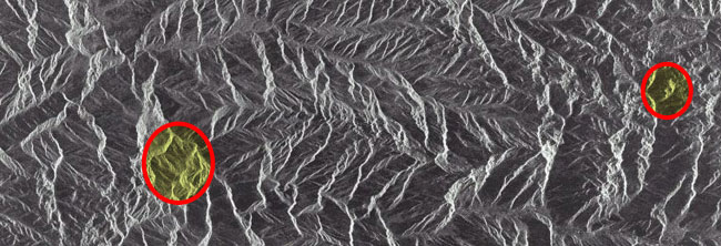
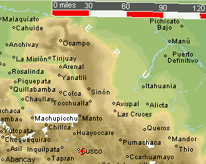
PART 10 - LIGHT AND SHADOW - THE FACE IN THE ANDES
On November 7, 1995, this satellite image of the Peruvian Andes was
generated by synthetic aperture radar.
This image may also be viewed
at NASA's Tropical Rainforest Information Center, on
tile X23 - mosaic 123 - image 151330724195311. On the left of the
image below is Machupicchu, Peru, although Machupicchu
does not have structures large enough to be clearly visible.
|
Near the line of ancient
sites, about twenty miles east of Machupicchu (on the
right) is the image pictured of a face.
|
 |
Back to Contents
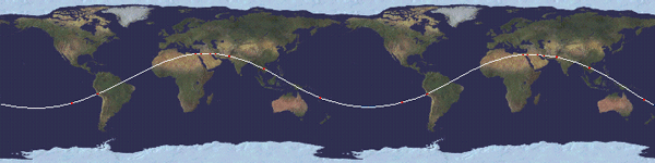
PART 11 - SINE LANGUAGE
As the Earth rotates on it’s axis, the Equator remains aligned, but
the line of ancient sites describes a sine wave as a
result of it’s
tilt relative to the Equator.
The line of the ecliptic
may be observed describing a similar wave by spinning a globe that
has a line of the ecliptic. The wave may also be visualized by
drawing the line of ancient sites on a flat projection of the
Earth.
Harmonics, electricity, and many other aspects of nature are
based on sine waves.
Because this particular wave repeats
with each full rotation of the earth, the frequency of the wave is
equal to the circumference of the Earth. The amplitude of this wave,
measured from the middle of the wave (the equator), is 30° of
latitude. Recall that the 30th parallels are ˝ of the height of each
hemisphere, or ˝ of the radius of the Earth.
Since the height of the wave is equal to ˝ of the Earth’s radius, the
ratio between the frequency of the wave and it’s amplitude is
4pi.
Measuring the amplitude from the top of the wavelength
to the bottom
(from 30° N to 30° S), the amplitude is equal to
the radius of the Earth, and the ratio between the frequency
and the amplitude of the wave is 2pi.
Back to Contents
PART 12 - CONCLUSION
Many similarities between these sites have been well documented,
including the use of perfectly cut and precisely placed monolithic
stones, exact orientations to the cardinal points and astronomical
orientations.
The prevailing view of world history dismisses these
similarities as coincidental developments of separate stone age
cultures. Unless it is also a coincidence that these sites
are located at mathematically and geometrically significant points
on a single line around the center of the Earth, it may be time to
reconsider the idea that Europeans of the present era were the first
to know the size and shape of the Earth.
|
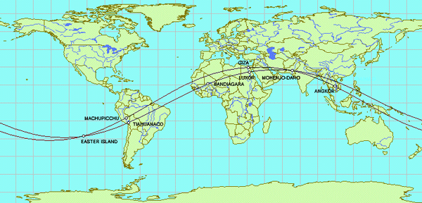
If the locations of all
of these sites is not a coincidence, and if there are sites yet to
be discovered along the line, one good place to look might be
halfway between the Great Pyramid and Machupicchu, just
south of the Cape Verde Islands.
Another good place to look might be halfway between the
Great Pyramid
and Easter Island, at 4° 19' North Latitude, 41° 30'
West Longitude, also under the North Atlantic Ocean:
G = Great Pyramid
A = Angkor Wat
V = Anatom Island
E = Easter Island
X = Atlantis?
|
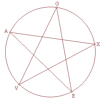 |
The distance from the Great Pyramid to Easter Island is
approximately 40% of the circumference of the Earth.
The X in the
diagram is halfway between the two, 20% each way. Machupicchu
is halfway between the X in the diagram and Easter Island,
10% each way. The Distance from the
Great Pyramid to Angkor Wat is
approximately 20% of the circumference, and the Indus Valley
is halfway between the two, 10% each way.
The Distance from
Easter Island to Angkor Wat is approximately
40% of the circumference, and Anatom Island is halfway
between them, 20% each way. These sites are located in multiples of
10% of the circumference of the Earth, and particularly at 20%
intervals.
Although there are no
islands near the location of the X in the diagram, it is interesting
to note that the famous
Piri
Reis map shows a large island in this location, and the
geology of recent core samples, taken from the ocean floor in this
area, is of continental rather than oceanic
type rock.
Back to Contents
PART 13 - COORDINATES, CALCULATION OF ALIGNMENT, OF ANCIENT
SITES
|
|
Latitude
|
Longitude
|
Distance To:
59°42'N 139°17'W
|
Distance To:
Line of
Ancient Sites
|
|
The Great Pyramid
|
29° 59' N
|
31° 09' E
|
6,215 miles
|
0 miles
|
|
Machupicchu
|
13° 06' S
|
72° 35' W
|
6,218 miles
|
3 miles
|
|
Nazca
|
14° 25' S
|
75° 20' W
|
6,215 miles
|
0 miles
|
|
Easter Island
|
27° 04' S
|
109° 22' W
|
6,224 miles
|
9 miles
|
|
Anatom Island
|
20° 10' S
|
169° 48' E
|
6,215 miles
|
0 miles
|
|
Angkor Vihear
|
14° 25' N
|
104° 40' E
|
6,215 miles
|
0 miles
|
|
Angkor Wat
|
13° 27' N
|
103° 53' E
|
6,300 miles
|
85 miles
|
|
Mohenjo Daro
|
27° 15' N
|
68° 17' E
|
6,222 miles
|
7 miles
|
|
Perseopolis
|
29° 50' N
|
52° 52' E
|
6,209 miles
|
6 miles
|
|
Ur
|
30° 57' N
|
46° 07' E
|
6,167 miles
|
48 miles
|
|
Petra
|
30° 09' N
|
35° 47' E
|
6,218 miles
|
3 miles
|
Back to Contents
PART 14 - OTHER GREAT CIRCLE ALIGNMENTS OF ANCIENT SITES
Back to Contents
14.1 - A SECOND ALIGNMENT WITH EASTER ISLAND AND MOHENJO-DARO
In Global Sacred Alignments, Terry Walsh diagrams
several alignments of ancient sites on straight lines around the
center of the earth, and mentions several others.
He addresses the
alignment of the Great Pyramid with Easter
Island, Machupicchu and
Perseopolis, and he diagrams an alignment of
Easter Island with
Tiahuanaco, Luxor,
Varanasi and Bandiagara, the ancient
capital city of the
Dogons.
This second
alignment also crosses over
Mohenjo Daro and
Ganweriwali in the Indus Vallley.
The total circumference of this second alignment is 24,892 miles.
The
great circle distance from Easter Island to
Tiahuanaco is 2,703 miles, 10.8% of the total circumference.
The distance from Tiahuanaco to Bandiagara is 4,930 miles, 19.8%. The distance from
Bandiagara to
Luxor is 2,473 miles, 9.9%.
The distance from
Luxor to
Easter Island’s antipodal point in the Indus
Valley near Ganweriwali is 2,363 miles, 9.5%.
Because Easter Island, Machupicchu, the Great Pyramid, the Indus Valley and
Angkor are also aligned at 10% intervals around the earth,
there is a high coincidence of paired sites along these two
alignments. In addition to the convergence of the two alignments at
Easter Island and Mohenjo-Daro,
Machupicchu is paired with
Tiahuanaco
and the Great Pyramid is paired with Luxor.
If the pairing of these sites along these two alignments is not a
coincidence, two good places to look for other ancient sites would
be in the Sahara Desert, near the border between Mali and
Mauritania, at 21° N, 7° 40' W, 2,488 miles
southwest of the Great Pyramid, and in the shallow water of the
South China Sea, just off the coast of Vietnam, at 18° 43' N,
106° 27' E, 2,488 miles southeast of
Mohenjo-Daro.
|
|
Latitude
|
Longitude
|
Distance To Axis Point:
59°42'N 139°17'W
|
Distance To:
Great
Circle
|
|
Easter Island
|
27° 04' S
|
109° 22' W
|
6,224 miles
|
9 miles
|
|
Machupicchu
|
13° 08' S
|
72° 30' W
|
6,218 miles
|
3 miles
|
|
The Great Pyramid
|
29° 59' N
|
31° 09' E
|
6,215 miles
|
0 miles
|
|
Petra
|
30° 09' N
|
35° 47' E
|
6,218 miles
|
3 miles
|
|
Perseopolis
|
29° 50' N
|
52° 52' E
|
6,209 miles
|
6 miles
|
|
Mohenjo Daro
|
27° 15' N
|
68° 17' E
|
6,222 miles
|
7 miles
|
|
Angkor Vihear
|
14° 25' N
|
104° 40' E
|
6,220 miles
|
0 miles
|
|
|
Latitude
|
Longitude
|
Distance To Axis Point:
62° 30' N 123° 10' W
|
Distance To:
Great
Circle
|
|
Easter Island
|
27° 04' S
|
109° 22' W
|
6,216 miles
|
1 mile
|
|
Tiahuanaco
|
16° 32' S
|
68° 42' W
|
6,187 miles
|
28 miles
|
|
Bandiagara
|
14° 21' N
|
3° 37' W
|
6,228 miles
|
13 miles
|
|
Luxor
|
25° 43' N
|
32° 35' E
|
6,208 miles
|
7 miles
|
|
Mohenjo-Daro
|
27° 15' N
|
68° 17' E
|
6,216 miles
|
1 mile
|
|
Varanasi
|
25° 21' N
|
82° 58' E
|
6,210 miles
|
5 miles
|
Back
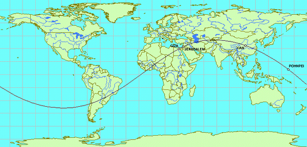
14.2 - A SECOND ALIGNMENT WITH THE GREAT PYRAMID
The Great Pyramid is aligned with the Temple Mount
in Jerusalem; the Chinese city of Xian, site of the terracotta
soldiers, the unexcavated tomb of Qin Shi Huang, the first Emperor
of China, and numerous other pyramids and burial mounds; and the
underwater ruins of Nan Madol that surround
Pohnpei Island.
|
|
Latitude
|
Longitude
|
Distance To Axis Point:
50° 40'N 103° 30'W
|
Distance To:
Great
Circle
|
|
The Great Pyramid
|
29° 59' N
|
31° 09' E
|
6217 miles
|
2 miles
|
|
Jerusalem
|
31° 44' N
|
35° 13' E
|
6213 miles
|
2 miles
|
|
Xian
|
34° 22' N
|
109° 'E
|
6236 miles
|
21 miles
|
|
Pohnpei
|
6° 56' N
|
158° 09 'E
|
6216 miles
|
1 mile
|
Back
|