|
KV 57 (Horemheb)
General Site Information
Structure: KV 57
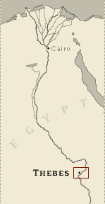
Location: Valley of the Kings, East Valley, Thebes West Bank, Thebes
Owner: Horemheb
Other designations:
Site type: Tomb
Description
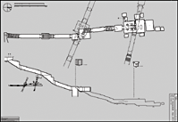
KV 57 is located in the west branch of
the southwest wadi. The tomb's opening, just above the Valley's
ancient floor, is low in the south side of a hill that projects
eastward into the central wadi from the cliff face where KV 35 (Amenhetep
II) is cut. Three sloping corridors (B, C, D) lead to a well chamber
(E) and a pillared chamber (F). A side descent and two sloping
corridors (G and H) lead to chamber I giving access to the burial
chamber J. This has side chambers (Ja-Je), also with side chambers (Jaa,
Jbb, Jcc, Jccc). The tomb represents a transition in tomb
architecture from the bent axis plan, characteristic of Dynasty 18,
to the straight axis royal tombs of Dynasties 19 and 20.
The decoration is composed of representations of deities (well
chamber E, chamber I, gate J, side chamber Jb), Horemheb with
deities (well chamber E, chamber I), and scenes from the Book of
Gates (burial chamber J).
Noteworthy features
This tomb descends with the steepness of
earlier tombs in the Valley of the Kings, but several unique
features were added. A ramp descending to a set of stairs was cut
between the pillars of the burial chamber J; a second set of stairs
was cut beside the first. Both lead to a crypt on a lower level.
Also, a lower side chamber (Jaa) was cut beneath side chamber Ja.
The decoration in the burial chamber and other parts of the tomb was
left in various stages of work, allowing scholars to study the
processes involved in preparing painted relief. KV 57 is the first
tomb to show the Book of Gates.
Site History
No remains of Horemheb were found, but evidence exists that the tomb
was at one time sealed, at least from gate F onwards. The broken lid
of the sarcophagus found lying on the floor, as well as the
shattered condition of the canopic chest and other burial
furnishings, suggest that the burial was robbed. Several hieratic
inspection dockets from Dynasty 21 may record temporary caching of
burials here before they subsequently were removed, perhaps to KV
35.
Dating
This site was used during the following period(s):
New Kingdom, Dynasty 18, Horemheb
Third Intermediate Period, Dynasty 21
History of
Exploration
Ayrton, Edward Russell (1908): Discovery (made for Theodore M.
Davis)
Ayrton, Edward Russell (1908): Excavation (conducted for Theodore M.
Davis)
Davis, Theodore M. (1912): Mapping/planning
Burton, Harry (1923): Photography (for the Metropolitan Museum of
Art)
Service des Antiquités (1934): Conservation
Hornung, Erik (1971): Photography (shot in color)
Supreme Council of Antiquities (1994-): Conservation
Conservation
- Conservation history: In 1934, the
Service des Antiquités carried out some restoration work in chamber
I. Following the closure of the tomb after the 1994 flooding,
conservation work has been carried out (particularly in rooms E, I,
and J) and walkways and lighting were installed.
- Site condition: Significant portions of
the painted decoration and blue background have flaked off the walls
in well chamber E and chamber I. When discovered, much damage had
already happened to the pillars and ceiling of the burial chamber.
The blocking of the doorway in the north (rear) wall of well chamber
E had been broken through in antiquity, resulting in damage to some
of the painted scene that covered it. Damage to the decoration
around gates I and J also occurred. This damage has since been
repaired.
Flooding in the Valley in October and November 1994 caused water to
enter the tomb and although much was caught in the shaft of well
chamber E, some water seeped across the bridge over the shaft and
entered the lower chambers. |
Printable Tomb Drawings
Axis in degrees: 357.72
Axis orientation: North
Site Location
Latitude: 25.44 N
Longitude: 32.36 E
Elevation: 173.242 msl
North: 99,518.773
East: 94,026.915
JOG map reference: NG 36-10
Modern governorate: Qena (Qina)
Ancient nome: 4th Upper Egypt
Surveyed by TMP: Yes
Measurements
Maximum height: 5.36 m
Minimum width: 0.66 m
Maximum width: 8.94 m
Total length: 127.88 m
Total area: 472.61 m²
Total volume: 1328.17 m³
Additional Tomb Information
Entrance location: Base of sloping hill
Owner type: King
Entrance type: Staircase
Interior layout: Corridors and chambers
Axis type: Straight
Decoration
Graffiti
Painting
Raised relief
Categories of Objects Recovered
Embalming equipment
Furniture
Human remains
Jewellery
Models
Sculpture
Tomb equipment
Vegetal remains
|