|
KV 42 (Hatshepsut-Meryet-Ra)
General Site Information
Structure: KV 42
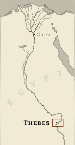
Location: Valley of the Kings, East Valley, Thebes West Bank, Thebes
Owner: Hatshepsut-Meryet-Ra
Other designations:
Site type: Tomb
Description
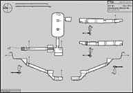
KV 42 is located in the south branch of
the southwest wadi. A steep stepped entryway (A), a steep corridor
(B), and a stairwell (C) lead down to a chamber (F) where the axis
turns ninety degrees to the left (east). Another corridor (G) leads
to the cartouche-shaped, pillared burial chamber J, which is flanked
by a side chamber (Ja). Except for an unfinished star pattern and a
kheker-frieze in burial chamber J, the tomb is undecorated.
Noteworthy features:
The cartouche-shaped burial chamber is
noteworthy.
Site History
Since the discovery of the foundation deposits bearing the name of
Hatshepsut-Meryet-Ra in 1921, there is no doubt concerning the
original owner of KV 42. The tomb was not finished or used by the
queen, the wife of Thutmes III. Instead, she might have been buried
in KV 35, the tomb of her son, Amenhetep II. KV 42 may have been
reused by Sennefer, mayor of Thebes, Senetnay, his wife, and Baketra,
the "king's adornment," during the reign of Amenhetep II or used as
a cache for materials from their burials elsewhere. The tomb was
plundered in antiquity.
Dating
This site was used during the following period(s):
New Kingdom, Dynasty 18, Thutmes III
History of
Exploration
Loret, Victor (1899): Discovery
Andraos, Boutros (1900): Excavation
Carter, Howard (1900): Excavation
Macarios, C. (1900): Excavation
Carter, Howard (1921): Excavation (discovery of foundation deposits)
Supreme Council of Antiquities (1999): Conservation
Supreme Council of Antiquities (1999): Excavation
Conservation
- Conservation history: The tomb has been
cleared recently by the Supreme Council of Antiquities.
- Site condition: KV 42 has suffered from
flood damage. Burial chamber J contains two pillars: the rear (west)
one is damaged and the front (east) one is broken.
|
Printable Tomb Drawings
Axis in degrees: 178.08
Axis orientation: South
Site Location
Latitude: 25.44 N
Longitude: 32.36 E
Elevation: 189.17 msl
North: 99,347.618
East: 94,092.171
JOG map reference: NG 36-10
Modern governorate: Qena (Qina)
Ancient nome: 4th Upper Egypt
Surveyed by TMP: Yes
Measurements
Maximum height: 4.32 m
Minimum width: 0.86 m
Maximum width: 7.61 m
Total length: 58.18 m
Total area: 184.77 m²
Total volume: 423.6 m³
Additional Tomb Information
Entrance location: Base of sheer cliff
Owner type: Queen
Entrance type: Staircase
Interior layout: Corridors and chambers
Axis type: Bent
Decoration
Graffiti
Painting
Categories of Objects Recovered
Architectural elements
Religious objects
Tomb equipment
Transport
Vessels
|