|
KV 39 (Amenhetep I (?))
General Site Information
Structure: KV 39
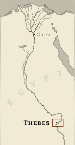
Location: Valley of the Kings, East Valley, Thebes West Bank, Thebes
Owner: Amenhetep I (?)
Other designations: 235 [Carter]
Site type: Tomb
Description
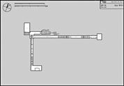
KV 39 is located at the head of a water course on the
plateau above and to the south of KV 34. The entryway stairway (A)
is cut in the side of the hill below al Qurn followed by a sloping
corridor (B1) that has been enlarged to the south at its lower end
(B1a). Beyond this corridor, a rectangular chamber (C1) extends to
the north of the axis. There is a stepped descent cut on the axis in
the floor at the south end of this chamber. Two other descending
corridors open off the south extension B1a. One descends southwards
from a stairwell in the floor and continues as a rough cut sloping
corridor (B3) to another stairwell (C4) leading to a rectangular
burial chamber (J2) extending to the east with a pit in the floor
beneath the rear wall. The other set of passages extends on a
west-east axis parallel to the entrance. A sloping corridor (B2)
descends to a stairwell (C2) followed by a second corridor ( D1) and
stairwell (C3), a short corridor (D2) and a low rectangular burial
chamber (J1).
Weigall's description of the tomb suggests that some decoration
remained intact at the time of his entry. All traces of decoration
were obliterated by the time Rose cleared the tomb. Weigall based
his belief that the tomb belonged to Amenhetep I on perceived
similarities of position between KV 39 and that described for
Amenhetep I's tomb in the tomb robbery papyri.
Noteworthy features
The tomb descends in three different directions
on three axes. Each axis consists of a series of corridors and two
at least end in rectangular chambers.
Site History
There appear to have been three construction phases, suggested by
differences in architectural typology and the orientation of
component groups. Entryway A, corridor B1, and chamber C1 and its
descent would have been cut first, and suggest a date in the first
half of Dynasty 18. Following a southward extension at the end of
the corridor B1, two other complexes of corridors and stairs leading
to burial chambers were cut to the south and to the east, although
it is not certain in which order these were done.
Dating
This site was used during the following period(s):
New Kingdom, Dynasty 18 (Date assigned by architectural typology)
History of Exploration
Andraos, Boutros (1900): Discovery
Andraos, Boutros (1900): Excavation
Macarios, C. (1900): Discovery
Macarios, C. (1900): Excavation
Carter, Howard (1916): Visit
Rose, John (1989, 1991-1994): Excavation
Buckley, Ian (2001-): Excavation
Buckley, Ian (2001-): Mapping/planning
Conservation
-
Site condition: The upper components of the tomb are cut in poor
quality shale and preserve less of their original surfaces. The
lower corridors and chambers are cut in better limestone, although
several large cracks or fissures have led to structural damage as
rock has fallen away. The lower chambers to the east were partly
filled with debris by the 1994 floods, although they are still
accessible. The southern corridors and chamber were completely
filled up to descent B1a..
|
Printable Tomb Drawings
Axis in degrees: 248.99
Axis orientation: West
Site Location
Latitude: 25.44 N
Longitude: 32.36 E
Elevation: 249.42 msl
North: 99,122.451
East: 94,127.795
JOG map reference: NG 36-10
Modern governorate: Qena (Qina)
Ancient nome: 4th Upper Egypt
Measurements
Maximum height: 4.94 m
Minimum width: 0 m
Maximum width: 3.92 m
Total length: 101.09 m
Total area: 193.69 m²
Total volume: 445.1 m³
Additional Tomb Information
Entrance location: Hillside
Owner type: Unknown, possibly royal
Entrance type: Staircase
Interior layout: Corridors and chambers
Axis type: Bent
Categories of Objects Recovered
Architectural elements
Clothing
Food
Human mummies
Jewellery
Mummy trappings
Religious objects
Tomb equipment
Vessels
Written documents
|