|
KV 21 (Unknown)
General Site Information
Structure: KV 21
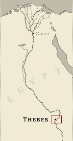
Location: Valley of the Kings, East Valley, Thebes West Bank, Thebes
Owner: Unknown
Other designations: 4 [Belzoni], T [Burton]
Site type: Tomb
Description
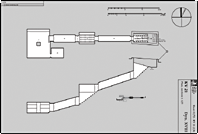
The tomb is located in the southeast
branch off the main wadi, north of KV 19. It is a small, undecorated
tomb, well cut with smoothed walls. The walls and ceiling bear red
and black mason's marks. It lies on an east-west axis and consists
of an entryway and two sloping corridors (B, D) with a stairwell (C)
between them. The second corridor leads to a burial chamber (J) with
a central pillar and a side chamber (Ja). There is a recess along
the right (north) side of the burial chamber.
Noteworthy features
The tomb is an example of burials of
Dynasty 18 royal family members. Burial chamber J has two noteworthy
features: a chamber-length recess and a single central pillar.
Site History
It has been suggested that the tomb was a queen's burial. Two female
mummies were found, with their left arm crossed on their chest, a
pose only used for queens. Vandals entered the tomb after its
discovery in 1817, broke up the mummies, hauled them up to the first
corridor B, and shattered some large white pots.
Dating
This site was used during the following period(s):
New Kingdom, Dynasty 18 (date based
on architectural typology)
History of
Exploration
Belzoni, Giovanni Battista (1817): Discovery
Belzoni, Giovanni Battista (1817): Excavation (conducted for Henry
Salt)
Burton, James (1825): Mapping/planning
Lefébure, Eugène (1889): Mapping/planning
Ryan, Donald P. (1989-1990): Excavation
Conservation
- Conservation history: In 1990 a security
gate was installed and to protect the bedrock during clearing,
wooden steps were added. The mummies were reassembled and returned
to the burial chamber in a specially constructed case.
- Site condition: The tomb suffered damage only after
its modern discovery. Burton referred to it as a "clean new tomb"
which had escaped even water damage. The second opening of the tomb
in 1989, however, revealed that the tomb had suffered flood damage
and was filling with silt debris. Standing water damaged artifacts
in the burial chamber as well as mummies which had been ravaged by
vandals following the tomb's initial opening in 1817.
|
Printable Tomb Drawings
Axis in degrees: 270
Axis orientation: West
Site Location
Latitude: 25.44 N
Longitude: 32.36 E
Elevation: 180.654 msl
North: 99,584.677
East: 94,244.664
JOG map reference: NG 36-10
Modern governorate: Qena (Qina)
Ancient nome: 4th Upper Egypt
Measurements
Maximum height: 5.71 m
Minimum width: 0.88 m
Maximum width: 6.78 m
Total length: 41.04 m
Total area: 120.29 m²
Total volume: 305.73 m³
Additional Tomb Information
Entrance location: Hillside
Owner type: Unknown, possibly royal
Entrance type: Staircase
Interior layout: Corridors and chambers
Axis type: Straight
Categories of Objects Recovered
Human mummies
Minerals
Scarabs and seals
Tomb equipment
Vessels
|