|
KV 10 (Amenmeses)
General Site Information
Structure: KV 10
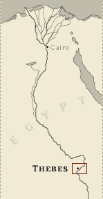
Location: Valley of the Kings, East Valley, Thebes West Bank, Thebes
Owner: Amenmeses
Other designations: 10 [Lepsius], 16 [Hay], 4e Tombeau à l'est
[Description], G [Burton], L, plan L [Pococke]
Site type: Tomb
Description
KV 10 is located in the main wadi. The
tomb consists of an open entryway (A) followed by three corridors
(B, C, D) with a small chamber off the right (west) wall of corridor
B (side chamber Ba). No well shaft was cut into the floor of chamber
E, and the cutting of side chamber Fa was never finished. Corridor
G, following the pillared chamber F, has a vaulted ceiling. The next
corridor (H) is unfinished, but would have led to a sarcophagus
chamber, if completed. The design of KV 10 from the entrance to
pillared chamber F is similar to KV 8, although the corridors have a
shallower slope.
The tomb was originally decorated for Amenmeses, with raised relief
on the lintel and jambs of gate B and in the entrance of corridor B.
The remainder of the texts and figures were in sunk relief,
extending as far as pillared chamber F. All of this decoration was
subsequently erased and replaced with painted plaster scenes for
Takhat and Baketwerel, with traces surviving in chamber E and
pillared chamber F. Graffiti are inscribed near the entrance.
Noteworthy features
This tomb is an example of the re-use of
a king's tomb for the burial of a queen with consequent extensive
alteration of decoration. This tomb is also of interest because of
the breakthrough by the cutting of KV 11.
Site History
KV 10 was cut during the reign of Amenmeses, but no evidence
survives to indicate that he was interred in the tomb. At some later
date, the tomb was usurped by Takhat, who bore the titles of king's
daughter and great royal wife, and another queen, Baketwerel. The
origins of these two royal women are not certain, but it is now
thought that they are related to Rameses IX of Dynasty 20. Early in
Dynasty 20, workmen were excavating KV 11 for Setnakht. While
digging corrridor D, they accidentally broke through the ceiling of
side chamber Fa in KV 10.
KV 10 has been partially open since antiquity, and there are Greek,
Arabic, and modern inscriptions on the walls at the entrance to the
tomb.
Dating
This site was used during the following period(s):
New Kingdom, Dynasty 19, Amenmeses
New Kingdom, Dynasty 20 (tomb re-used for burial of
Queen Takhat and Baketwerel)
Graeco-Roman Era
History of Exploration
Pococke, Richard (1737-1738): Mapping/planning
Burton, James (1825): Mapping/planning ( to rear of tomb)
Wilkinson, John Gardner (1825-1828): Mapping/planning
Hay, Robert (1825-1835): Mapping/planning
Franco-Tuscan Expedition (1828-1829): Epigraphy
Lepsius, Carl Richard (1844-1845): Epigraphy (copying of scenes in
gates B, E and F and dry squeezes of Baketwerel)
Lefébure, Eugène (1883): Epigraphy
Ayrton, Edward Russell (1907): Excavation (most of corridor B for
Theodore M. Davis)
Schaden, Otto J. (1992-1999): Excavation (clearance from gate C to
end of tomb)
Schaden, Otto James (1997-2000): Conservation
Conservation
- Conservation history: In several places on the walls
and ceilings of the corridors and chambers, plaster patches and
Avongard crack monitoring strips have been placed to indicate rock
movement. To date, except for the badly broken "ceiling" of corridor
H, no significant movement has been detected. In 1997, the low wall
in front of KV 10 was raised to protect the tomb from floodwaters.
Pillar 4 was replaced in 1998 with one built of limestone blocks,
while pillar 1 was consolidated with a veneer of limestone slabs.
Similar treatment was carried out in 1999 and 2000 on pillars 2 and
3.
- Site condition:
As a result of flooding at various times over the centuries, since
the tomb first was left open, much damage has occurred to the
decorated plaster on the walls and ceilings, and even to the stone
itself. Most of the painted plaster wall decoration of chamber E and
pillared chamber F was destroyed in a flood in 1916 or earlier. Only
a few fragments of painted plaster and carved limestone survive in
KV 10. Numerous areas of ancient repairs made by the tomb builders
to the walls, ceilings and floors are visible, usually mud, plaster
and stone chips filling cracks. The four pillars in pillared chamber
F are severely damaged: pillar 4 is almost completely missing.
Pillars 2 and 3 were detached from the ceiling and were held up only
by the debris that surrounded them. Only pillar 1 is still
relatively intact, although much of the surface of its lower half
has broken away. Corridors G and H exhibit the most extensive
damage, including large fissures, surface spalling and, particularly
in corridor H, extensive ceiling collapse. |
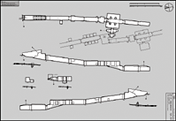
Printable Tomb Drawings
Axis in degrees: 191.04
Axis orientation: South
Site Location
Latitude: 25.44 N
Longitude: 32.36 E
Elevation: 174.445 msl
North: 99,552.060
East: 94,071.652
JOG map reference: NG 36-10
Modern governorate: Qena (Qina)
Ancient nome: 4th Upper Egypt
Surveyed by TMP: Yes
Measurements
Maximum height: 3.84 m
Minimum width: 0.98 m
Maximum width: 9.47 m
Total length: 105.34 m
Total area: 350.27 m²
Total volume: 821.23 m³
Additional Tomb Information
Entrance location: Base of sloping hill
Owner type: King
Entrance type: Ramp
Interior layout: Corridors and chambers
Axis type: Straight
Decoration
Grafitti
Painting
Raised relief
Sunk relief
Categories of Objects Recovered
Tomb equipment
Vessels
|