|
SKV 7 (Rameses II)
General Site Information
Structure: KV 7
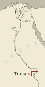
Location: Valley of the Kings, East Valley, Thebes West Bank, Thebes
Owner: Rameses II
Other designations: 10 [Hay], 7 [Lepsius], 8 [Champollion], C [Pococke],
Commencement d'excavation ou grotte fermée [Description], K [Burton]
Site type: Tomb
Description
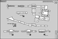
KV 7, located in the main wadi, is one
of the larger tombs in the Valley of the Kings. Three sloping
corridors (B, C, D) lead to a well chamber (E) and a pillared
chamber (F) with two side chambers (Fa, Faa). A central descent and
two corridors (G, H) lead to an another chamber (I). In this
chamber, a change of axis occurs to the right (northeast) and leads
to the burial chamber J and its six adjacent side chambers (Ja-f).
Side chamber Jd has two side chambers (Jdd, Jddd).
The design of KV 7 conforms to the bent axis plan: the entrance to
the tomb is dug into the Theban limestone hillside near the valley
floor, and the passage descends for about 58 meters (190 feet) into
the bedrock at an angle that varies between 12 and 22 degrees. It
then continues approximately level for another 12 meters (39 feet),
then turns to the right and terminates in the burial chamber J,
which is partly carved in a layer of Esna shale.
Since the entrance to KV 7 lies at a particularly low spot in the
Valley, it has been vulnerable to flooding, with evidence of several
incidents preserved in the layers of debris fill. Because of the
flood damage, much of the wall decoration is damaged or missing, but
most of the scenes can be reconstructed from fragments.
KV 7 is decorated with scenes from the Book of Gates (burial chamber
J, side chamber Ja, side chamber Jd), Book of the Dead (stairwell C,
chamber I, side chamber Jddd), Book of the Heavenly Cow (side
chamber Jf), Imydwat (corridor D, well chamber E, burial chamber J,
side chamber Jb, side chamber Jc, side chamber Jd, side chamber Je),
Litany of Ra (corridor B, gate C, stairwell C), Opening of the Mouth
Ritual (corridor G, gate H, corridor H), the deceased and deities
(corridor B, gate D, well chamber E, gate I, chamber I, gate J,
burial chamber J, gate Ja, gate Jddd, gate Je, side chamber Jc, side
chamber Jd, side chamber Jdd, side chamber Jddd, side chamber Je),
and representations of funerary objects (burial chamber J, side
chamber Jdd).
The decorative program includes two new features: the lintel and
jambs of the first gate (B). The basic decorative plan follows the
example of KV 17 (Sety I), with figures and inscriptions done in
raised and sunk relief.
Noteworthy features
This is the first king's tomb in the
lower part of the central wadi. There are several architectural and
decorative innovations including a return to the bent axis plan and
a decorated gate B.
There are several unique features as well. There are several large
side chambers off burial chamber J. There is an Osiris figure in a
recess in side chamber Je. The doors of gate E opened outwards. The
well shaft was decorated.
Site History
The tomb was open in antiquity, but it been almost completely filled
with flood debris since then. According to the "Strike Papyrus" in
the Turin Museum, two tomb robbers tried to enter KV 7 during the
regnal year 29 of Rameses III in Dynasty 20. In Dynasty 21, Rameses
II's mummy was moved first to KV 17, then to the cache in the tomb
of Queen Inhapy at Dayr al Bahri, TT 320, where it was found in
1881.
Dating
This site was used during the following period(s):
- New Kingdom, Dynasty 19, Rameses II
- Graeco-Roman Era
- New Kingdom, Dynasty 21
- New Kingdom, Dynasty 20, Rameses III
History of Exploration
Pococke, Richard (1737-1738): Mapping/planning
Napoleonic Expedition (1799): Mapping/planning
Burton, James (1825): Mapping/planning
Franco-Tuscan Expedition (1828-1829): Epigraphy
Lepsius, Carl Richard (1844-1845): Epigraphy
Lepsius, Carl Richard (1844-1845): Excavation
Lepsius, Carl Richard (1845): Mapping/planning
Burton, Harry (1913-1914): Excavation (conducted on behalf of
Theodore M. Davis)
Maystre, Charles (1938): Epigraphy
Maystre, Charles (1938): Excavation
Brooklyn Museum (1978): Excavation
Theban Mapping Project (1979): Mapping/planning
Leblanc, Christian (1993-): Conservation
Leblanc, Christian (1993-): Excavation
Leblanc, Christian (2002): Epigraphy
Salt, Henry (ca. 1817): Excavation
Salt, Henry (ca. 1817): Visit
Conservation
-
Conservation history: The tomb is currently undergoing excavation by
C. Leblanc. In the process, cracked sections of the ceiling of the
burial chamber Jand other chambers are being reinforced by
staineless steel rods and plates.
-
Site condition: The tomb of Rameses II provides an example of the
flood damage that tombs in the Valley of the Kings have endured over
the centuries. KV 7 has sustained damage from at least ten major
floods. The first water damage was probably done to the tomb after
the Graeco-Roman period. The different floods are distinguishable in
the debris layers in the tomb, with pieces of wall decoration wedged
between layers of silt, gravel, and soil. |
Printable Tomb Drawings
Axis in degrees: 324.76
Axis orientation: Northwest
Site Location
Latitude: 25.44 N
Longitude: 32.36 E
Elevation: 169.75 msl
North: 99,621.308
East: 94,063.747
JOG map reference: NG 36-10
Modern governorate: Qena (Qina)
Ancient nome: 4th Upper Egypt
Surveyed by TMP: Yes
Measurements
Maximum height: 5.82 m
Minimum width: 0.74 m
Maximum width: 13.06 m
Total length: 168.05 m
Total area: 868.4 m²
Total volume: 2286.43 m³
Additional Tomb Information
Entrance location: Base of sloping hill
Owner type: King
Entrance type: Ramp
Interior layout: Corridors and chambers
Axis type: Bent
Decoration
Grafitti
Painting
Raised relief
Sunk relief
Categories of Objects Recovered
Sculpture
Tomb equipment
Vessels
|