|
KV A (Unknown)
General Site Information
Structure: KV A
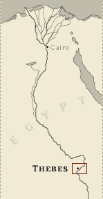
Location:, Thebes West Bank, Thebes
Owner: Unknown
Other designations: WV A, WVA
Site type: Tomb
Description
KV A, located in the main wadi of the
West Valley, is cut into the base of the cliff at the head of a
water course 60 meters (197 feet) south of the entrance to KV 22. An
entryway of rough steps (A) descends to a gate (B) that still
retained much of its rubble blocking. The single chamber B inside
the gate was partly filled with limestone chips and dirt. Numerous
fragments of broken pottery vessels, some with blue painted
decoration, were found in the debris. Jar sealings and dockets name
Amenhetep III and give dates in his regnal years 32 and 37. Other
artifacts are associated with tomb decoration, including limestone
ostraca with sketches, ceramic fragments used for holding pigments,
lumps of plaster, and rope.
Noteworthy features
The original blocking of gate B was
found almost intact.
Site History
It is not known whether this tomb's construction was contemporary
with that of KV 22 (Amenhetep III) or if it predates it. From the
nature of the artifacts found in the debris, it appears to have been
first used to store equipment during the construction of KV 22.
Subsequently vessels belonging to Amenhetep III's burial equipment
were stored here. Other artifacts belonging to the king's burial,
such as part of a leather quiver, are thought to have come from
debris removed from KV 22. There was no evidence from the artifacts
of a burial there.
Dating
This site was used during the following period(s):
New Kingdom, Dynasty 18, Amenhetep
III (or earlier)
History of
Exploration
Hay, Robert (1825-1835): Visit
Lepsius, Carl Richard (1844-1845): Excavation
Ayrton, Edward Russell (1905): Excavation
Chassinat, Emile (1905-1906): Excavation
Burton, Harry (1912): Excavation
Jones, Ernest Harold (1912): Excavation
Waseda University (1993-1994): Excavation
Conservation
- Conservation history: The remaining
ancient blocking of the gate has been supplemented, following the
clearance of the tomb, with additional rubble blocking.
- Site condition: Much of the original blocking of the
tomb remains.
|
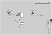
Printable Tomb Drawings
Axis in degrees: 222.72
Axis orientation: Southwest
Site Location
Latitude: 25.44 N
Longitude: 32.36 E
Elevation: 178.01 msl
North: 99,623.449
East: 93,564.798
JOG map reference: NG 36-10
Modern governorate: Qena (Qina)
Ancient nome: 4th Upper Egypt
Surveyed by TMP: Yes
Measurements
Maximum height: 2.42 m
Minimum width: 1.71 m
Maximum width: 4.86 m
Total length: 9.64 m
Total area: 28.53 m²
Total volume: 42.14 m³
Additional Tomb Information
Entrance location: Base of sheer cliff
Owner type: Unknown, probably non-royal
Entrance type: Staircase
Interior layout: Chamber
Axis type: Straight
Categories of Objects Recovered
Cordage
Jewellery
Scarabs and seals
Vessel stands
Vessels
Written documents
|