|


by
Harry Mason
Geologist-Geophysicist - Perth
Western Australia
December 29 2004
from
Rense Website
Interestingly with amazing prescient
"co-incidence" The Australian GeoScience Organisation -
AGSO - ran
an article in its
AUSTGEO NEWS for
September 2004 about the risk factors for
earthquakes
and consequent tsunamis developing off the SW coast of Sumatra.
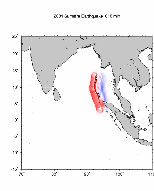
See above file - note the AGSO model for a possible
SW
Sumatra tsunamis and compare with the recent Tsunami Animation:
Courtesy: National Institute of Advanced Industrial Science and
Technology, Japan (below image).
Press "F5" in your
keyboard so see effects in above image
(from
http://iri.columbia.edu/~lareef/tsunami/)
AGSO got it nearly right but failed to (publicly at least ) predict
that multiple earthquakes would let rip along most of the entire
Sumatra-Andaman shear zone and that this would create multiple
tsunamis and that these would funnel up the Bay of Bengal and across
to Sri Lanka with such DEADLY force. The AGSO model
(above image) showed the
tsunamis vectoring SW into the un-inhabited section of the Indian
Ocean.
This is similar to the amazing coincidence of the Worlds foremost
authorities on earthquakes and seismic events being in Tokyo for a
major conference when disaster struck Kobe a few years ago, or the
marine survey being located off shore of southern New Guinea when
the "on fire" tsunamis hit their north coast. None of these
coincidences on their own are out of the question BUT when taken as
a class one has to seriously wonder...
The BIG question is was this AGSO report just an amazing
co-incidence or were they asked to model the SW Sumatra area by
someone wanting to know what might happen if the plate boundary was
tickled by
energetic scalar EM ??? The same area of
the 9.2 richter quake has been the site of deliberate use of
scalar EM to whip up cyclones (hurricanes). A Malaysian
newspaper ran that story a few years back implying a deal between
the Malaysian government and a Russian state owned
company to create a cyclone to push smoke from
Indonesian forest fires offshore. The actual
cyclone creation event
was visible on weather imagery shown on West Australian TV during
the 7.00pm ABC weather news. It consisted of an annular ring say 50
miles in diameter consisting of multiple micro spirals (each say 5
miles in diameter) in edge contact - each micro-spiral being created
sequentially until the annular ring was closed back to the first
micro-spiral. Within a day the cyclone centered upon the angular
ring had begun to spin up to full power.
If AGSO were "simply" being prescient their guys deserve high
accolade. However prescience is not something for which AGSO is
normally known. However if the study was requested from "on high" we
have a potential conduit to the source. It will be interesting to
see if AGSO suffers senior staff loss by suicide in the new year.
|