|

by AJStrata
June 26, 2008
from
Strata-Sphere
Website
Spanish version
One of the disconnects the Church of
Al Gore/IPCC has yet to address
regarding so-called Global Warming is why is it the Arctic ice
extent is receding (thus all the chicken-little screams) while the
Antarctic ice extent is growing at historic rates.
Given the fact CO2 levels are
ubiquitous across the Earth, if this was really a global climate
driver we should see higher temperatures (and less ice) across the
globe, adjusted for latitude and the amount of land vs. sea surface
area.
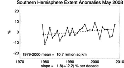
Here is the Northern ice extent plots
from NOAA:
And here is the southern ice extent
plots:
Well it seems we may have an answer to
why the Arctic water temperatures were rising and the ice was
melting - massive undersea volcanoes:
Recent massive volcanoes have risen
from the ocean floor deep under the Arctic ice cap, spewing
plumes of fragmented magma into the sea, scientists who filmed
the aftermath reported Wednesday.
The eruptions - as big as the one that buried Pompei - took
place in 1999 along the Gakkel Ridge, an underwater mountain
chain snaking 1,800 kilometers (1,100 miles) from the northern
tip of Greenland to Siberia.
Scientists suspected even at the time that a simultaneous series
of earthquakes were linked to these volcanic spasms.
But when a team led of scientists led by Robert Sohn of the
Woods Hole Oceanographic Institution in Massachusetts finally
got a first-ever glimpse of the ocean floor 4,000 meters (13,000
feet) beneath the Arctic pack ice, they were astonished.
What they saw was unmistakable evidence of explosive eruptions
rather than the gradual secretion of lava bubbling up from
Earth’s mantle onto the ocean floor.
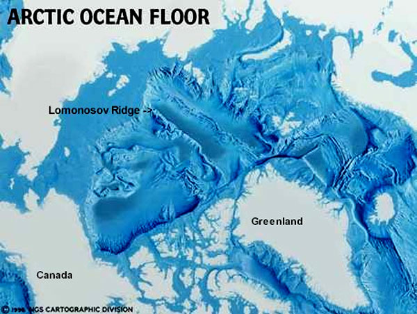
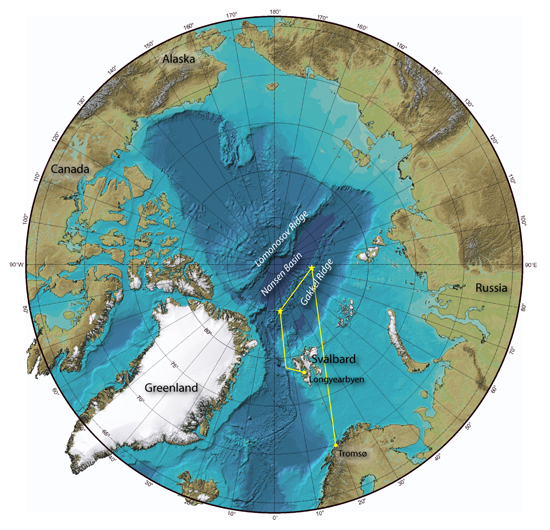
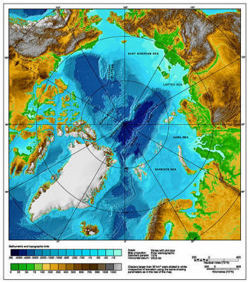
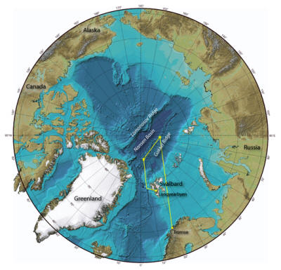
Folks need to understand that the Arctic
Ocean is a fairly closed system because it resides in a large bowl
shaped depression with only limited outlets that rise to much
shallower depths, as seen in the following picture:
The natural basin that is the Arctic Ocean is possibly the reason
why Arctic water temperatures were rising because the warming caused
by these massive underwater explosions couldn’t really circulate out
of the basin.
Is this the real culprit for why the ice
and glaciers have been receding in the Arctic and ice as been
growing in the Antarctic?
Seems highly possible.

Update
In case folks are wondering
the Gakkel Ridge is that ridge
running through the middle of the basin.
Update
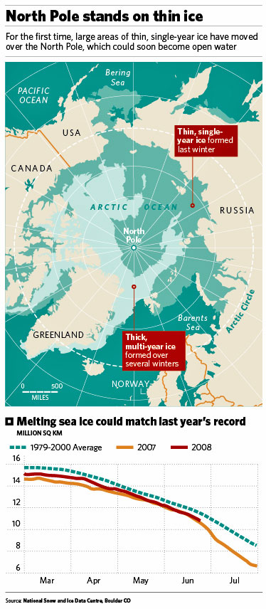
Is it simply coincidence that the
regions of the Arctic Ocean experiencing thin ice (which
has so many ‘scientists’ blowing hot air about Global Warming)?
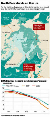
The Diminishing Polar Ice
Is the same region that is right over
these massive undersea volcanoes just discovered?
Seriously, I doubt this is
coincidence.
I would need to see exact locations of
the volcanoes, the deep sea current paths and a depth chart to be
sure, but it seems obvious to me that the warm waters and thin ice
are to the Russian side of the
Lomonosov Ridge, which cuts the
Arctic Ocean basin in half - the same side as the Gakkel Ridge where
the volcanoes are.
And it is not surprising the warm water
from the volcanoes has risen to the surface and spread out into the
shallow continental shelf where it stays warmers. That is exactly
how one would expect the warm water to travel out of the hot spot
near the North Pole.
Looks like the Arctic Ocean is going to be the place that destroys
the Global Warming mythology. How appropriate!
Update
More here from
National Geographic, which notes
these eruptions generated the largest earthquake swarm in recorded
history along these kinds of spreading ocean ridges.
This earthquake swarm was the
largest in recorded history along a spreading mid-ocean ridge
and prompted researchers to return to the area for further
investigation.
In 2007 Sohn and his team stumbled across the glassy pyroclastic
rock deposits while searching for hydrothermal vent fields in
the Gakkel Ridge.
Powerful eruptions sent a plume of carbon dioxide, helium, and
liquid lava up into the Arctic waters. When the material cooled,
rock debris fell to the ocean floor, he explained.
The article actually confirms some of my
initial speculation on how this event could have created significant
warming in the region that now shows thin ice.
“The dispersal of the particles does
not necessarily indicate that the eruptions were highly
energetic, only that the eruption heated the surrounding
seawater and the rising plume of heated water carried the lava
fragments upwards where currents could disperse them,” Clague
said.
And
this article notes the swarm
included over 300 quakes, which is why the region is now being
investigated.
“The Gakkel Ridge is covered
with sea-ice the whole year. To detect little earthquakes,
which accompany geological processes, we have to deploy our
seismometers on drifting ice floes.”
This unusual measuring method proved
highly successful: in a first test in the summer 2001 during the
“Arctic Mid-Ocean Ridge Expedition (AMORE)” on the research
icebreaker Polarstern the seismometers recorded explosive sounds
by the minute, which originated from the seafloor of the
volcanic region.
“This was a rare and random
recording of a submarine eruption in close proximity,” says
Schlindwein. “I postulated in 2001 that the volcano is still
active. However, it seemed highly improbable to me that the
recorded sounds originated from an explosive volcanic
eruption, because of the water depth of 4 kilometers.”
The scientist regards the matter
differently after her participation in the Oden-Expedition 2007,
during which systematic earthquake measurements were taken by
Schlindwein’s team in the active volcanic region:
“Our endeavours now concentrate
on reconstructing and understanding the explosive volcanic
episodes from 1999 and 2001 by means of the accompanying
earthquakes. We want to know, which geological features led
to a gas pressure so high that it even enabled an explosive
eruption in these water depths.”
Like Robert Reves-Sohn, she presumes
that explosive eruptions are far more common in the scarcely
explored ultraslow-spreading ridges than presumed so far.
And even
more here:
The Arctic seabed is as explosive
geologically as it is politically judging by the “fountains” of
gas and molten lava that have been blasting out of underwater
volcanoes near the North Pole.
“Explosive volatile discharge
has clearly been a widespread, and ongoing, process,”
according to an international team that sent unmanned probes
to the strange fiery world beneath the Arctic ice.
They returned with images and data
showing that red-hot magma has been rising from deep inside the
earth and blown the tops off dozens of submarine volcanoes, four
kilometers below the ice.
“Jets or fountains of material
were probably blasted one, maybe even two, kilometers up
into the water,” says geophysicist Robert Sohn of the Woods
Hole Oceanographic Institution, who led the expedition.
Again,
-
Why is it not plausible that the
Arctic Melt is actually the result of volcanic activity that rivals
that which buried Pompeii?
-
Can the IPCC actually claim this historic
level of volcanic activity is having negligible impact on Arctic
Ice?
Gimme a break...
Update
BTW, Symonsez you need to check out
this post.
Update
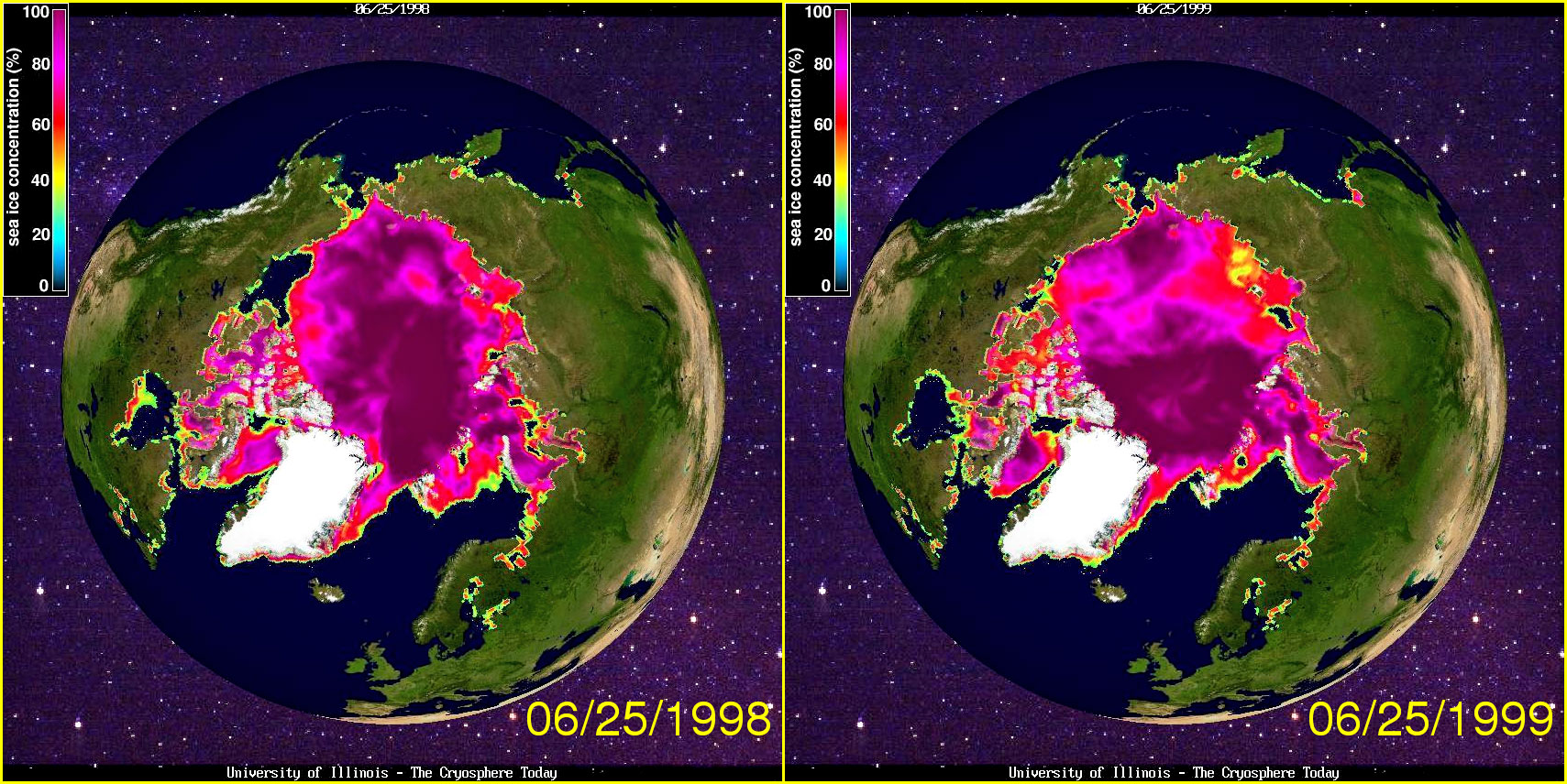
Reader Crosspatch pointed me to a site
which can show comparisons of arctic ice depths across two years. So
I decided to look at 1998 (before the volcanic explosions) and 1999
(after).
Here is what the results show:
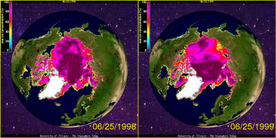
Dark Purple is thick ice, reds and
yellows thin ice.
What is interesting to note is the 1999
year shows the shallow edges thinning out dramatically - which makes
sense. The heated sea water would rise and probably run across the
thicker ice, spreading, and possibly settling against the north
coast of Russia. It would take time to actually melt thick ice.
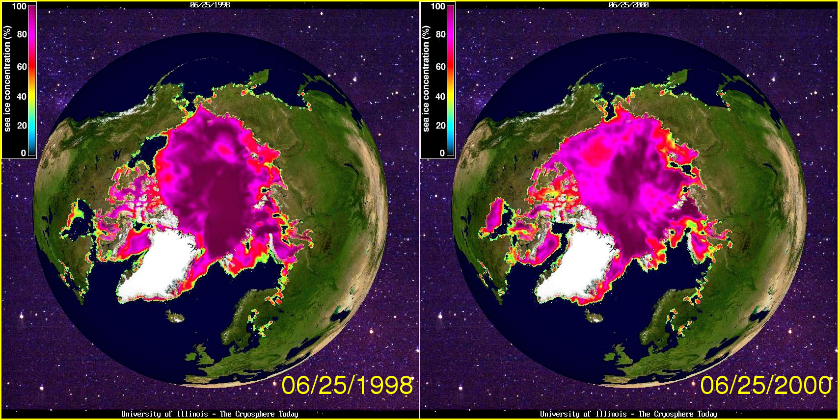
So I did a second comparison, 1998 to
2000, to see what heating over time might do - and it looks like a
hole starts to develop (red area) right about where these explosions
and venting took place:

By 2001 the depth of snow and ice
returns to typical levels. In fact, if you
compare 2008 to 1999, 2008 is
looking like it will do better. Anyway, I am not sure if this
effected Arctic Ice depths and extent - but I cannot see how if
couldn’t have some effect.
Addendum
After getting some sleep on the matter I
wanted to add one more observation to this.
Ice thickness is important to the
underwater shape of the ice sheet. As folks know with ice bergs, 90%
of the ice mass extends below the water’s surface. Areas of thick
ice look like inverted mountains while areas of thin ice look like
the valleys.
Super heated water rising from the sea floor would hit the upside
down mountain peaks first, and then start to flow towards the
thinner ice as it rises - which is why you could get hot spots
(which would look like basins in relief on the bottom topology of
the ice sheet). The interesting thing about the 2008 ice thickness
data is it looks like it large, long ‘valleys’ formed, just like
rushing water forms valleys from storm run off.
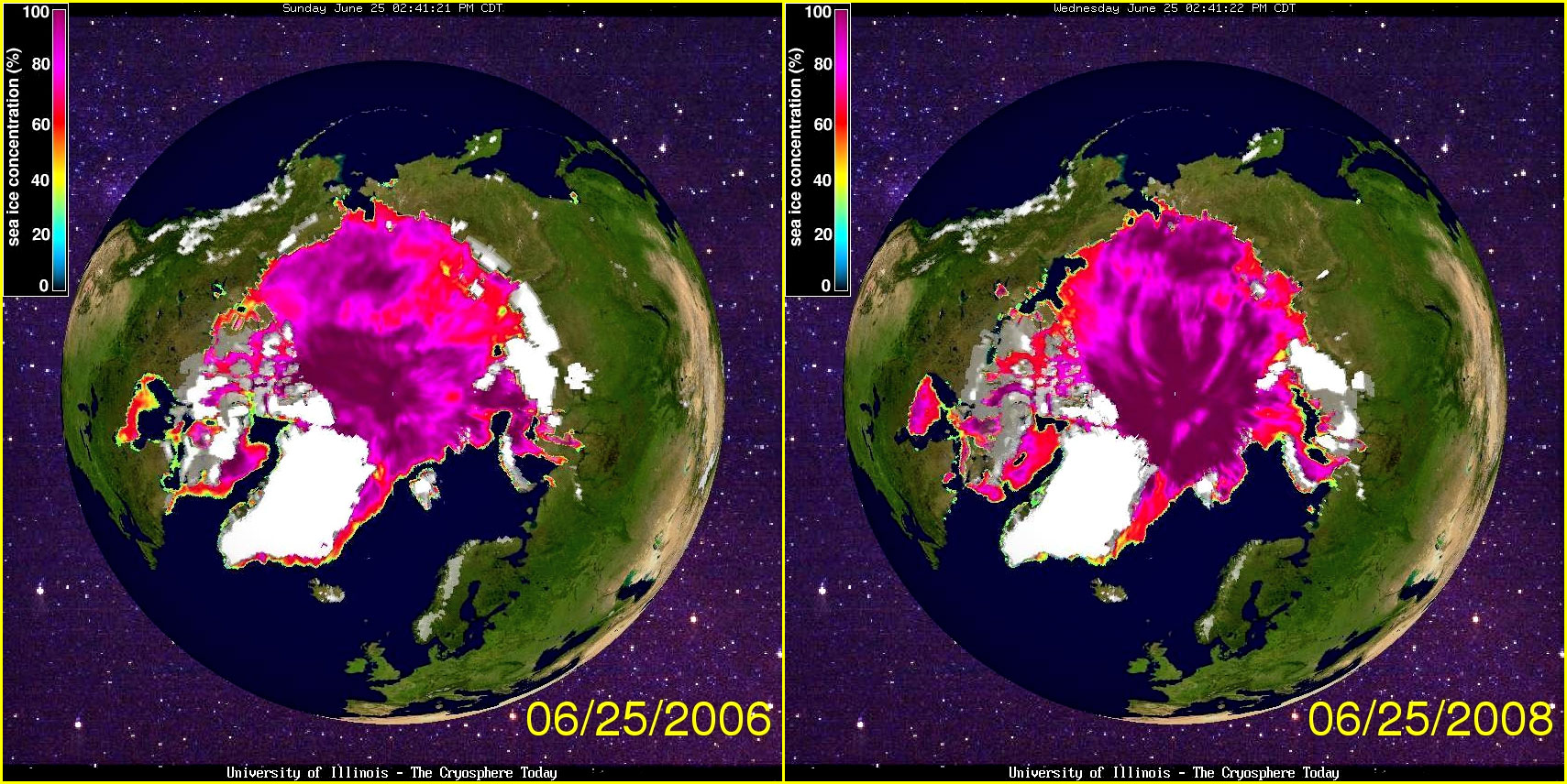
I have added a 2006-2008 comparison to
show these features.
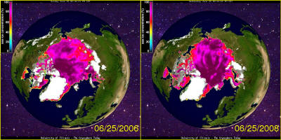
In the 2006 picture the ice sheet is
lumpy, where dark regions reflect where the ice protrudes the
farthest underwater, the light purple being regions where the ice is
not as deep, and red/yellow thin spots.
2006 is interesting because there was
another warm spot forming off the coast of Russia - which could mean
the volcanoes were active or whatever. But 2008 is interesting with
its radiating bands of light and dark purples, looking just like
valleys etched by flowing water from a single point along the same
ridge as the volcanoes.
Am I seeing things? Who knows - again I don’t have the data to do
any analysis, don’t have any seismic recordings to compare to the
annual sea ice thickness, don’t have current maps. Hopefully some
real scientists will have the money and time to work this all out.
Seems it would be prudent before we make
today’s energy prices a fond memory as we embark on a fool’s errand
to cut CO2 emissions to no effect.
Final Update
Sweetness & Light has a graph of
what appears to be average ice thickness, which shows 1999 - the
year of the massive eruptions - as the point when the Arctic Ice
started melting in earnest:
Given the fact this graph looks to
be from the bible of the Church of Al Gore it seems hard not to
notice the 1999 impact from the volcanoes and demand an
explanation from Gore and the IPCC.
Final, Final Update
It seems there is a lot of information
out on the Arctic Ocean and these volcanoes which has not been
correlated yet.
Here is a
2007 news report on the Arctic
Ocean circulation patterns, which have been shifting dramatically
over the last 20 years or so. These shifting patterns are the result
of salinity changes - which could be a direct result of the volcanic
activity changing salinity levels and causing the changes.
The take away conclusion from this is
the activity is not driven by CO2 or “Global Warming”:
A team of NASA and university
scientists has detected an ongoing reversal in Arctic Ocean
circulation triggered by atmospheric circulation changes that
vary on decade-long time scales. The results suggest not all the
large changes seen in Arctic climate in recent years are a
result of long-term trends associated with global warming.
This is “NASA” too, as much as that
extremist Hansen is (probably more so because these folks run the
science missions, Hansen just attempts to understand the data and
has a proven history of botching even that).
Like I said way, way, way up in this now
way too long post, it looks like the Global Warming myths may die
cold death in the Arctic Ocean physical processes.
Volcanic Eruptions
...Reshape
Arctic Ocean Floor
26 June 2008
Agençe France-Presse
from
CosmosMagazine Website
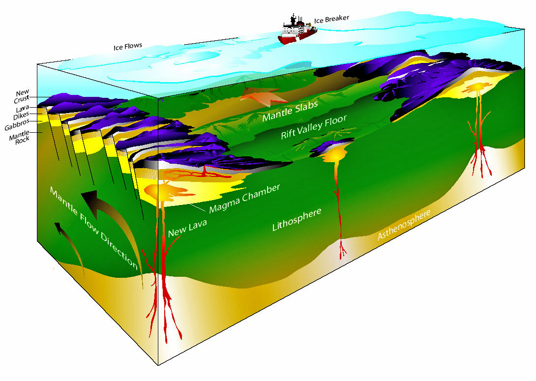
Arial view of Gakkel
Ridge beneath the Arctic ocean
Reconstruction of the Gakkel Ridge beneath the Arctic ocean,
where a valley filled with
flat-topped volcanoes up to 2 km wide
and hundreds of meters high has
been found.
Credit: Woods Hole Oceanographic Institution
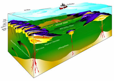
A diagram of the
spreading Arctic seafloor
A block model of the ultraslow spreading Gakkel Ridge in the Arctic
showing two volcanoes with a
large segment of mantle exposed on the seafloor between them.
Credit: Paul Oberlander, WHOI
PARIS
Recent massive volcanoes have
risen from the ocean floor deep under the Arctic ice cap, spewing
plumes of fragmented magma into the sea, scientists who filmed the
aftermath have reported.
The eruptions - as big as the one that buried Pompei - took place in
1999 along
the Gakkel Ridge, an underwater
mountain chain snaking 1,800 km from the northern tip of Greenland
to Siberia.
Scientists suspected even at the time that a simultaneous series of
earthquakes were linked to these volcanic spasms.
But when a team led of scientists led by Robert Sohn of the
Woods Hole Oceanographic Institution in Massachusetts, USA,
finally got a first-ever glimpse of the ocean floor 4,000 meters
beneath the Arctic pack ice, they were astonished.
What they saw was unmistakable evidence of explosive eruptions
rather than the gradual secretion of lava bubbling up from Earth's
mantle onto the ocean floor.
Previous research had concluded that this kind of so-called
pyroclastic eruption could not happen at such depths due to the
crushing pressure of the water.
"On land, explosive volcanic
eruptions are nothing exceptional, although they present a major
threat," said Vera Schlindwein, a geologist with Germany's
Alfred Wegener Institute for Sea and Polar Research, which took
part in the study.
But the new findings, published in the
British journal Nature, showed that,
"large-scale pyroclastic activity is
possible along even the deepest portions of the global mid-ocean
ridge volcanic system."
The mid-ocean ridge runs 84,000 km
beneath all the world's major seas except the Southern Ocean, and
marks the boundary between many of the tectonic plates that make up
the surface of the Earth.
When continental plates collide into each other, they can thrust up
mountain ranges such as the Himalayas.
But along most of the mid-ocean ridge - including the Gakkal Ridge -
the plates are pulling apart, allowing molten magna and gases
trapped beneath the crust to escape.
Sohn and his colleagues gathered their data in July last year aboard
the ice breaker Oden, using state-of-the-art instruments including a
multibeam echo sounder, two autonomous underwater vehicles and a
sub-ice camera designed for the mission.
Both sonar and visual images showed an ocean valley filled with
flat-topped volcanoes up to 2 km wide and several hundred meters
high.
|