by Harry L. Bryden et. al.

Nature v.438

1 December 2005
from MindFully Website


All authors contributed equally to this work.

Received 8 April; accepted 28 October 2005

Harry L. Bryden1, Hannah R. Longworth1

& Stuart A. Cunningham1
1 - National Oceanography Centre, Empress Dock, Southampton SO14 3ZH, UK.


The Atlantic meridional overturning circulation carries warm upper waters into far-northern latitudes and returns cold deep waters southward across the Equator1.


Its heat transport makes a substantial contribution to the moderate climate of maritime and continental Europe, and any slowdown in the overturning circulation would have profound implications for climate change. A transatlantic section along latitude 25° N has been used as a baseline for estimating the overturning circulation and associated heat transport.2-4


Here we analyze a new 25° N transatlantic section and compare it with four previous sections taken over the past five decades. The comparison suggests that the Atlantic meridional overturning circulation has slowed by about 30 per cent between 1957 and 2004.


Whereas the northward transport in the Gulf Stream across 25° N has remained nearly constant, the slowing is evident both in a 50 per cent larger southward-moving mid-ocean recirculation of thermocline waters, and also in a 50 per cent decrease in the southward transport of lower North Atlantic Deep Water between 3,000 and 5,000 m in depth.


In 2004, more of the northward Gulf Stream flow was recirculating back southward in the thermocline within the subtropical gyre, and less was returning southward at depth.

Some climate models suggest that the anthropogenic increase in atmospheric carbon dioxide will result in a slowdown of the Atlantic overturning circulation5. Coupled climate model runs that had the Atlantic overturning circulation shut off exhibited a cooling over northwest Europe with temperatures 4°C lower than at present6.


Thus, any indication of a slowdown in the Atlantic overturning circulation has profound implications for climate change.


In March 2004 we deployed an array of moored instruments along 25° N to begin to monitor the overturning circulation 7 and in April-May we took a transatlantic hydrographic section along 25°N to provide an initial calibration for the time-series array measurements8.

The 25°N transatlantic hydrographic section was occupied in 1957 (ref. 9), in 1981 (ref. 3) and again in 1992 (ref. 10). Analysis of these three occupations suggested that the overturning circulation and heat transport at 25°N had been reasonably constant with only relatively small changes in thermocline, intermediate and deep water transports.3,4


In 1998, the 25° N section was again occupied,11 so the section of 2004 marked the fifth complete transatlantic section along 25° N. Here we analyze the new 2004 section and the 1998 section using methods similar to those previously developed for the 1957, 1981 and 1992 sections 2,4 and examine the structure of the overturning circulation for all five sections.

Each section extends from the African continental shelf to the Bahama Islands (Fig. 1).


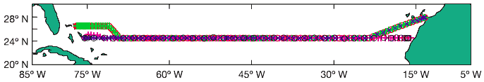
The 1957 and 1992 sections were effectively along 24.5° N over the entire width of the Atlantic. The 1981, 1998 and 2004 sections angled southwestward from the African continental shelf at about 28° N to join the standard 24.5° N section at about 23.5° W.


To take advantage of the continuous electromagnetic cable monitoring of Gulf Stream transport through the Florida Straits12, the 1998 and 2004 sections angled northwestward at about 73° W to complete the section along 26.5° N.

The analysis calculates geostrophic velocities for each station pair along the section.


A reference level of 3,200 dbar (decibar) is used for station pairs east of the western boundary region where current meter observations suggest 1,000 dbar to be more suitable.4,13 The transition between the two reference levels is identified from the distribution of dissolved oxygen concentration that marks the eastern edge of the boundary region 4 and ranges from 68.38 W to 70.68 W.


The concept behind the analysis is to estimate the annual average over-turning, so the annual averaged wind-driven surface Ekman transport and the annual averaged Gulf Stream transport through Florida Straits must be balanced by the overall southward geostrophic transport across the mid-ocean section.


Thus a uniform reference level velocity is added everywhere along the section to force the mid-ocean geostrophic transport to balance the Gulf Stream plus Ekman transport.


This approach assumes that the large-scale baroclinic interior flow does not vary on seasonal or shorter timescales; theoretical arguments and modeling results support such an assumption.14,15

Gulf Stream transport through the Florida Straits has been reasonably constant at 32.2 Sv (1 Sv = 106 m3 s-1) since 1980 (refs 12, 16) with a standard deviation in annual mean transport of 1.1 Sv.


Sporadic estimates of Gulf Stream transport back to the 1960s16-19 and cable estimates of transport since 2000 (ref. 20) show no evidence of changes in annual averaged transport through.


Figure 1


Station positions for transatlantic hydrographic sections taken in 1957, 1981, 1992, 1998 and 2004.


The 1957 and 1992 sections each went zonally along 24.5° N from the African coast to the Bahamas Islands. Because of diplomatic clearance issues, the 1981, 1998 and 2004 sections angled southwestward from the African coast at about 28° N to join the 24.5° N section at about 23° W.


The 1998 and 2004 sections angled northwestward at about 73° W to finish the section along 26.5° N.


Figure 2


Vertical distribution of mid-ocean meridional geostrophic flow across 25° N section.


Transport per unit depth (in m2 s-1) represents the zonally averaged northward geostrophic velocity times the zonal distance across the section at each depth.

  1. Top-to-bottom profile showing the general similarity in vertical structure of the flow for each section with southward flow in the upper waters, a northward flow of intermediate waters, a southward flow of deep waters at 1,200-5,000 m depth, and a northward flow in the bottom waters

  2. Expanded profile of the thermocline flow showing the stronger southward flow in the 1998 and 2004 sections

  3. Expanded profile below 1,000 m depth showing the two cores of southward flowing upper NADW centered at about 2,000 m depth and lower NADW centered at 4,000 m depth, the Florida Straits larger than 2 Sv.


In the SOC and NCEP wind stress climatologies,21,22 the mean Ekman transport at 25.5° N is 3.8 Sv (SOC) or 3.6 Sv (NCEP) and the variability in annual averaged Ekman transport is 0.6 Sv.


There is no significant change in Ekman transport at 25° N over time in either the SOC or NCEP climatologists.


There is a small net southward transport across 25° N associated with the 0.8 Sv Bering Straits through-flow from the Pacific which is diminished by a net evaporation of order 0.1 Sv over the Atlantic north of 25° N (ref. 23) but this is smaller than the uncertainty in the calculations.

Here, to be consistent with previous analyses of the 25° N sections,4 we use a constant northward Ekman transport for each section of 5.4 Sv (ref. 24) and a constant Gulf Stream transport of 30.2 Sv for the early sections finishing at 24.5° N, and 32.2 Sv for the 1998 and 2004 sections ending at 26.5° N.


The difference of 2 Sv is due to the flow through the northwest Providence channel25 that joins the Gulf Stream flow north of 24.5° N to make up the 32.2 Sv measured by cable at 26.5° N.


In summary, the southward mid-ocean geostrophic transport equals 35.6 Sv for the 1957, 1981 and 1992 sections and 37.6 Sv for the 1998 and 2004 sections. From the observed variability, we estimate that the uncertainty in forcing the southward mid-ocean geostrophic transport to equal a constant value for each of the five sections is only ±2 Sv.

The overall vertical structure of the mid-ocean geostrophic circulation is similar for the five sections (Fig. 2a): there is surface-intensified southward flow in the thermocline above a depth of 800 m, small northward flow of intermediate waters between about 800 and 1,200 m, southward flow below 1,200 m down to about 5,000 m and northward flow below 5,000 m.


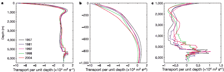
The strength of the flows has changed, however. In the main thermocline, the southward flow is much stronger between 100 and 600 m depth in 2004 (Fig. 2b) so that the mid-ocean southward transport above 1,000 m depth has increased from 13 Sv in 1957 to nearly 23 Sv in 2004 (Table 1).


In the deep waters the southward transport between 1,000 and 3,000 m that is associated with upper North Atlantic Deep Water (NADW) originating in the Labrador Sea has remained reasonably constant, varying between 9 and 12 Sv; below 3,000 m, however, the southward transport of lower NADW originating in the Greenland-Iceland Norwegian Sea has steadily decreased from 15 Sv in 1957 to 7 Sv in 2004 (Table 1).


Not only has the lower-NADW transport decreased but the bottom part of the flow is gone: in 1998 and 2004 the flow passes through zero at about 4,800 m depth, whereas in earlier sections the southward flow extended down to 5,200 m (Fig. 2c).

The changes in transport distribution along 25° N are described in Supplementary Figs S1 and S2. In temperature (water mass) classes, the results are effectively the same. Thermocline waters defined to be waters warmer than 9.5° C exhibit an increase in southward transport from 16 Sv in 1957 to 24 Sv in 2004 (Supplementary Table S1).


Lower NADWs defined to have temperatures between 1.8 and 2.5° C exhibit a consistent decrease in southward transport from 16 Sv in 1957 to 7 Sv in 1998 and 2004.

Estimates of geostrophic transport for transoceanic sections rely heavily on the stations close to the eastern and western boundaries, because these end stations effectively set the overall baroclinic shear in the currents above 1,000 m depth and the upper-level transport.


The variability near the western boundary is evident in Supplementary Fig. S3, so we can argue that the upper 1,000 m transport depends critically on the nature of the western end station: for example, whether it is inside or outside an eddy.


Careful consideration of the errors in geostrophic transports derived from transoceanic sections and simulated in ocean circulation models led Ganachaud to the conclusion that there is an error of ± 6 Sv in overall upper and lower layer transports.26


Although there is little error in overall transport owing to the constraint of basin-scale mass conservation (as discussed above), there is an uncertainty of ± 6 Sv in upper layer transport that is due to sampling in or out of eddies, and because there must be compensation by deep flows, there is also an uncertainty in deep transport of ± 6 Sv.


The increased southward thermocline transport of 8 Sv and the 9 Sv decrease in lower-NADW transport in the 2004 section are close to this expected uncertainty.


Table 1  Meridional transport in depth classes across 25° N

					1957 	1981 	1992    1998 	2004
Shallower than 1,000 m depth
	Gulf Stream and Ekman 		+35.6 	+35.6 	+35.6 	+37.6 	+37.6
	Mid-ocean geostrophic 		-12.7 	-16.9 	-16.2 	-21.5 	-22.8
  	Total shallower than 1,000m	+22.9 	+18.7 	+19.4 	+16.1 	+14.8
1,000–3,000m 				-10.5 	 -9.0 	-10.2 	-12.2	-10.4
3,000–5,000m 				-14.8 	-11.8 	-10.4 	 -6.1 	 -6.9
Deeper than 5,000m 			 +2.4 	 +2.1 	 +1.2 	 +2.2 	 +2.5

Values of meridional transport are given in Sverdrups (Sv). Positive transports are northward.


Two aspects of the 2004 circulation convince us that the changes are not due to end-station variability.


First, the increased southward thermocline transport is a result of substantially warmer waters in the thermocline near the Bahamas. Temperatures between 400 and 800 m depths are 1 to 2°C 8 warmer in 2004 and the 14°C  8, 12° C  8 and 9.5° C 8 isotherms are 75 m deeper in 2004 than they were in 1957, 1981 or 1992.


This warming is not restricted just to the end-stations but extends eastward from the Bahamas over several hundred kilometers. These deeper isotherms and warmer thermocline waters near the western boundary lead to a steeper slope of the thermocline across the basin and to larger overall southward geostrophic currents in the thermocline relative to a deeper reference level.


The result is larger southward mid-ocean flow above 1,000 m depth and the smaller overall northward transport when the Gulf Stream and Ekman transports above 1,000 m depth are added (Table 1). Smaller net northward transport across 25° N is consonant with a reported reduction in overall northward flow through the subpolar gyre based on satellite measurements27.

The second convincing aspect is that the deep compensation for the increased southward thermocline transport does not occur uniformly with depth. The simplest way for the analysis method to compensate for an 8 Sv increase in southward thermocline transport would be to adjust the entire deep-water flow uniformly so that both upper- and lower-NADW transports would decrease by about 4 Sv.


Instead, the observed structure shows that the upper NADW trans-port from 1,000 to 3,000 m depth has not changed and effectively only the lower NADW transport has decreased. In the deep water, this change is visually evident in an upward slope of the 3°C 8 isotherm to the west in the 1998 and 2004 sections that was not evident in the earlier sections.


This slope leads to reduced southward flow of lower NADW beneath the southward core of upper NADW at about 1,800 dbar (Fig. 2b).


Thus, there have been subtle changes in the structure of the deep-water circulation, resulting only in decreased lower NADW transport. Such a reduction in lower-NADW transport is consonant with observations of the cessation of lower-NADW formation in the Norwegian-Greenland Sea 28 and the general freshening and weakening of the flow of lower NADW coming over the northern sills.29,30

We accept that the uncertainty in transport structure for the 2004 section is ± 6 Sv in the upper and lower layer transports and that the observed changes are uncomfortably close to these uncertainties.


But the warmer waters near the western boundary in the 1998 and 2004 section leading to an increase in southward mid-ocean recirculation in the thermocline and the reduction in deep water flow only in lower NADW represent strong arguments that the observed changes are robust.


The decrease in net northward flow of warm upper waters and decrease in net southward flow of cold deep waters across the 25° N section result in a reduction of the northward heat transport across 25° N from 1.3-1.4 PW (1 PW = 1015 W) for the 1957, 1981 and 1992 sections to 1.1 PW for the 1998 and 2004 sections.


Notes

1. Bryden, H. L. & Imawaki, S. in Ocean Circulation and Climate (eds Siedler, G., Church, J. & Gould, J.) Ch. 6.2 455--474 (Academic, London, 2001).
2. Hall, M. M. & Bryden, H. L. Direct estimates and mechanisms of ocean heat transport. Deep-Sea Res. 29, 339--359 (1982).
3. Roemmich, D. & Wunsch, C. Two transatlantic sections: meridional circulation and heat flux in the subtropical North Atlantic Ocean. Deep-Sea Res. 32, 619--664 (1985).
4. Lavín, A., Bryden, H. L. & Parrilla, G. Meridional transport and heat flux variations in the subtropical North Atlantic. Glob. Atmos. Ocean Syst. 6, 269--293 (1998).
5. Cubasch, U. et al. in Climate Change 2001: The Scientific Basis (ed. Houghton, J. T.) Ch. 9, 525--582 (Cambridge Univ. Press, Cambridge, UK, 2001).
6. Vellinga, M. & Wood, R. A. Global climatic impacts of a collapse of the Atlantic thermohaline circulation. Clim. Change 54, 251--267 (2002).
7. Srokosz, M. New experiment deploys observing array in N. Atlantic to investigate rapid climate change. Eos 85(8), 78--83 (2004).
8. Cunningham, S. A. RRS Discovery Cruise 279 (04 Apr--10 May 2004): A Transatlantic Hydrography Section at 24.5° N Cruise Report 54, 1--199 (Southampton Oceanography Centre, Southampton, 2005) ( http://eprints.soton.ac.uk/17527/ ).
9. Fuglister, F. C. Atlantic Ocean Atlas of Temperature and Salinity Profiles and Data from the International Geophysical Year of 1957--1958. Woods Hole Oceanographic Institution Atlas Series 1, 1--209 (WHOI, Woods Hole, Massachusetts, 1960).
10. Parrilla, G., Lavín, A., Bryden, H., Garcia, M. & Millard, R. Rising temperatures in the subtropical North Atlantic Ocean over the past 35 years. Nature 369, 48--51 (1994).
11. Baringer, M. O’N. & Molinari, R. Atlantic Ocean baroclinic heat flux at 24 to 26° N. Geophys. Res. Lett. 26, 353--356 (1999).
12. Baringer, M. O’N. & Larsen, J. C. Sixteen years of Florida Current transport at 27° N. Geophys. Res. Lett. 28, 3179--3182 (2001).
13. Bryden, H. L., Johns, W. E. & Saunders, P. M. Deep western boundary current east of Abaco: Mean structure and transport. J. Mar. Res. 63, 35--57 (2005).
14. Gill, A. E. & Niiler, P. P. The theory of the seasonal variability in the ocean. Deep-Sea Res. 20, 141--177 (1973).
15. Jayne, S. R. & Marotzke, J. The dynamics of ocean heat transport variability. Rev. Geophys. 39, 385--411 (2001).
16. Larsen, J. C. Transport and heat flux of the Florida Current at 27° N derived from cross-stream voltages and profiling data: theory and observations. Phil. Trans. R. Soc. Lond. A 338, 169--236 (1992).
17. Schmitz, W. J. Jr & Richardson, W. S. On the transport of the Florida current. Deep-Sea Res. 15, 679--693 (1968).
18. Richardson, W. S., Schmitz, W. J. Jr & Niiler, P. P. The velocity structure of the Florida Current from the Straits of Florida to Cape Fear. Deep-Sea Res. 16 (suppl.), 225--231 (1969).
19. Niiler, P. P. & Richardson, W. S. Seasonal variability of the Florida Current. J. Mar. Res. 31, 144--167 (1973).
20. Meinen, C. S., Baringer, M. O. & Garcia, R. Florida Current Transport ( http://www.aoml.noaa.gov/phod/floridacurrent ) (NOAA/AOML, Miami, Florida, 2005).
21. Josey, S. & Grist, J. The NOC (formerly SOC) Air-Sea Flux Climatology ( http://www.noc.soton.ac.uk/JRD/MET/fluxclimatology.php ) (National Oceanography Centre, Southampton, 2005).
22. Woodruff, S. NCEP Real-time Marine Data ( http://www.cdc.noaa.gov/cdc/data.nmc.marine.htm ) (NOAA/Climate Diagnostics Center, Boulder, Colorado, 2005).
23. Wijffels, S. E., Schmitt, R. W., Bryden, H. L. & Stigebrandt, A. Transport of freshwater by the oceans. J. Phys. Oceanogr. 22, 155--162 (1992).
24. Trenberth, K. E., Large, W. G. & Olson, J. G. The mean annual cycle in global ocean wind stress. J. Phys. Oceanogr. 20, 1742--1760 (1990).
25. Leaman, K. D. et al. Transport, potential vorticity, and current/temperature structure across Northwest Providence and Santaren Channels and the Florida Current off Cay Sal Bank. J. Geophys. Res. 100, 8561--8569 (1995).
26. Ganachaud, A. Error budget of inverse box models: The North Atlantic J. Atmos. Ocean. Technol. 20, 1641--1655 (2003).
27. Häkkinen, S. & Rhines, P. B. Decline of subpolar North Atlantic circulation during the 1990s. Science 304, 555--559 (2004).
28. Řsterhus, S. & Gammelsrod, T. The abyss of the Nordic Seas is warming. J. Clim. 12, 3297--3304 (1999).
29. Dickson, B. et al. Rapid freshening of the deep North Atlantic Ocean over the past four decades. Nature 416, 832--837 (2002).
30. Hansen, B., Turrell, W. R. & Řsterhus, S. Decreasing outflow from the Nordic seas into the Atlantic Ocean through the Faroe Bank channel since 1950. Nature 411, 927--930 (2001).


Acknowledgements

The 2004 transatlantic hydrographic section along 25° N was supported by the Natural Environment Research Council as part of the Core Strategic Research Program ‘Ocean Variability and Climate’ at Southampton Oceanography Centre.


Analysis of the five sections along 25° N was also supported by NERC as part of the Rapid Program.


Comments on an earlier draft by J. Hirschi, W. Johns, S. Josey, C. Meinen, G. Parrilla, P. Rhines, P. Saunders, J. Toole, P. Velez and R. Wood led to substantial improvement.