|

by William Hutton
Spanish version
May 10, 2002
Last Updated: November 09,
2002
from
HuttonCommentaries Website
Introduction
The notion of a lost continent beneath the Pacific Ocean seems
preposterous. But there are many stories and books that reference
such a place.
Col. James Churchward wrote
five books on the lost continent of Mu (also called Lemuria).1-4
More about Churchward’s works later.
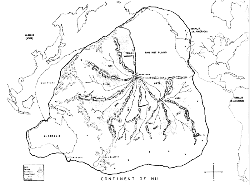
There is even a group called “The
Lemurian Fellowship” located in Ramona, California, which
has published its concept of a map of the lost continent
(see Fig. 1).

Fig. 1 - Continent of
Mu (According to the Lemurian Fellowship).
click image to
enlarge
Psychic
Information
The map of Figure 1 is, presumably,
psychically derived. Interestingly, it shows that portions of far
northeastern Lemuria were located in western America. This rendering
seems to echo the following Cayce reading.
Before that we find the entity was
in that land now known as the American, during those periods
when there were the changes that had brought about the sinking
of Mu or Lemuria, or those peoples in the periods
who had changed to what is now a portion of the Rocky Mountain
area; Arizona, New Mexico, portions of Nevada and Utah.
The entity then was among the princesses of the land that
established there the teachings of the Law of ONE, from the
activities in the land which had brought destructive forces
through the separations from those things that made for the love
of the individual for the gratifying of selfish motives.
Then the entity established what may be called the home life in
that land, as each home became then as the castle of place of
worship - or activities that were separated, yet united in one
as for purposes. The name then was Ouowu.
851-2; January 31, 1935
Next we have the story of Phylos,
a disincarnate master who was channeled by F.S. Oliver in
1883. 5 Whatever one
may think of Edgar Cayce’s psychic readings, Phylos was
implied to be a credible source in one of them (#364-1). In his
book, Phylos speaks of a previous life on Lemuria. He
describes "queer little horses, having three toes to each foot and
high shoulders," a "great house built of stone," and a swarthy,
brown-skinned man, "his hands talon-like." Such information
indicates a late Miocene time at the earliest -- up to nine million
years ago -- and an earlier race of man.
The Cayce readings refer to a lost continent in the Pacific
by several names, but most often it is called Lemuria. Other
names are Mu, Zu, Lu, and possibly Oz.
Some of these may refer to provinces of the continent, or to
portions left after a major break-up of the land.
Here are three representative readings.
Before this we find the entity in
that land now known as the American, during the periods when the
Lemurian or the lands of Mu and Zu were being in their turmoils
for destruction.
And the entity was among those that -- in what is now not far
from that land in which the entity in this sojourn first saw the
light [the woman requesting the reading was born in the Santa
Rosa/Petaluma, California area -- (that must in the near
future fade again into those joinings with the land of Mu)
-- established a temple of worship for those that escaped from
the turmoils of the shifting of the Earth at that particular
period.
The entity, in the name Oeueou, established near what is
now Santa Barbara the temple to the sun and the moon; for the
satellite of the moon had not faded then., and there was
enjoined as to the entity in the worship as the goddess to the
moon and the sun....
(509-1; 2/5/34)
What "satellite of the moon?" How
did it "fade?" By impacting the moon? At what location? Was this a
natural or a man-made satellite? If man-made, what was it used for?
Navigation and/or communications? For whom and by whom? Were aliens
involved? 6
Here are the second and third examples of the numerous Cayce
readings that reference the lost continent of Lemuria:
Before that we find that the entity
was in that land known as Mu, or the vanished land of the
Pacific, the Peaceful; during those periods when many of those
had risen to power when there were being those banishments and
preparations for the preserving; for they had known that the
land must soon be broken up.
(630-2)
Before this we find the entity was in that land that has been
termed Zu, or Lemuria, or Mu. This was before the sojourn of
peoples in perfect body form; rather when they may be said to
have been able to -- through those developments of the period --
be in the body or out of the body and act upon materiality. In
the spirit or in the flesh these made those things, those
influences, that brought destruction ...
(436-2)
Here we have reference to a time when
souls could act directly upon materiality. This aspect of the
readings’ references to Lemuria finds resonance in the book,
Atlantis to the Latter Days 7.
The work is said to have been inspirationally dictated to Mr.
Randall-Stevens by two disincarnate masters.
According to the author’s discourse, the actual disintegration of
Lemuria occurred over a period of many thousands of years. It,
"was accomplished as the outcome of
a series of volcanic disturbances which gradually undermined the
substrata comprising the foundations of that continent."
The disaster was brought about on
account of the.... domination exercised by the Devil and his
followers. Randall-Stevens goes on to say,
“Black magic was rife and the
chances of those who still remained steadfast to the cause of
divine evolution were almost hopeless.....During previous
periods all those who were to be collected in Atlantis had been
ordered to proceed to that continent."
Randall-Stevens writes that the
final destruction of Lemuria occurred about 30,000 years
ago.
Submergence of Lemuria must have had worldwide geophysical
consequences. The date of 30,000 B.P. coincides with the second
period of disturbance on Atlantis when "there were [produced] small
channels through many of the lands" (470-22).
But reading 364-4
seems to imply that the final demise of Lemuria occurred perhaps
only 10,700 years before the final destruction of Atlantis, or
22,600 years ago.
….the variations [in the spiritual,
material, and commercial aspects of Atlantis] as we find, extend
over a period of some two hundred thousand years - that is, as
light years - as known in the present - and that there were MANY
changes in the surface of what is now called the Earth.
In the
first, or greater portion, we find that NOW known as the
southern portions of South America and the Antarctic or North
Antarctic regions, while those in what is NOW as Siberia - or that
as of Hudson Bay - was rather in that region of the tropics, of
that position now occupied by near what would be as the same
LINE would run, of the southern Pacific, or central Pacific
regions - and about the same way.
Then we find, with this change that
came first in that portion, when the first of those peoples used
that as prepared FOR the changes in the Earth, we stood near the
same position as the Earth occupies in the present - as to
Capricorn, or the equator, or the poles.
Then, with that
portion, THEN the south Pacific, or Lemuria, began its
disappearance - even before Atlantis, for the changes
were brought about in the latter portion of that period, or what
would be termed ten thousand seven hundred (10,700) light years,
or Earth years, or present setting of those, as set by
Amilius - or Adam.
Scientific
Information That Suggests Lemuria Once Existed
Can science shed any light on the possible reality of Lemuria? Do we
have any evidence that the floor of the Pacific could once have been
elevated over a continental-sized area?
Consider the May, 1998,
review paper by Marcia McNutt, entitled simply,
Superswells. 8
We have heard of hotspots that invoke narrow, isolated upwellings
from deep within the Earth, like the hotspot produced by a thermal
plume that some geologists think was responsible for the
Hawaiian-island chain. Such a hotspot is surrounded by shallow
seafloor less than about 1000 km in cross-sectional diameter, called
a "swell."
A "superswell" is also believed to reflect mantle
upwelling. But it expresses itself as an extensive, anomalously
shallow area of the seafloor. And its scale is several thousand
kilometers across. This is as large, for example, as the island
continent of Australia.
McNutt’s review of several lines
of geophysical evidence allows her to conclude that one of the best
examples of mantle-convective origin of an Earth feature is the
South Pacific Superswell (SPS). (See Figure 1
for a partial outline of the SPS).
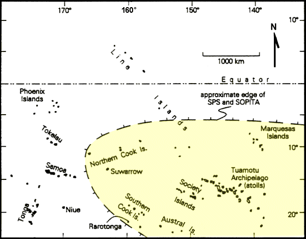
Fig. 2 - Island
groups of part of the tropical Pacific Ocean, as modified from
Figure 1 of W. Dickinson’s article,
“Paleoshoreline
Record of Relative Holocene Sea Levels On Pacific Islands,”
Earth-Science
Reviews, 55, 2001.
The approximate,
coincident edges of the South Pacific Superswell (SPS)
and the South Pacific
Isotopic and Thermal Anomaly (SOPITA)
shown in yellow are
after McNutt (1998, Fig 17) and Staudigel et al. (1991, Fig. 1).
This is "a broad area of uplifted
seafloor containing numerous volcanoes in French Polynesia." The
boundaries of this superswell contain the Society, Cook, Austral,
Tuamotu, Marquises, and Easter island chains. These islands reflect
an enhanced rate of volcanism in the superswell area due to enormous
quantities of hot mantle rock below the ocean floor.
If the South Pacific Superswell were once above sea level,
forming the continent of Lemuria, it would have been buoyed
up by a broad bulge in the mantle, much like that recently inferred
to be buoying up the lofty peaks and plateaus of the American West.
A renewal of mantle upwelling beneath the SPS could result in the
seafloor there rising above the waves once again.
Such activity
would bear out the statement in Cayce reading 1152-11
(8/13/41) which says that,
"In the next few years, lands will appear
in the Atlantic as well as in the Pacific."
If we can put any credence at all in the geophysical evolution and
eventual disappearance of Lemuria, just what might the evidence be
for Lemuria’s origin? The answer may lie in the line of reasoning
advanced in our last article, on the origin of Atlantis, as based on
the hypothesis of Prof. MacKenzie Keith
9
On page 301 of Keith’s seminal
review article, the author begins by reminding us that the plate
tectonics hypothesis includes the postulate that,
“volcanism can be attributed to
[crust and mantle] downflow and recycling at the recognized
subduction zones of Indonesia and the Pacific rim, but to
upwelling and decompression melting at mid-ocean ridges and
‘hotspots’. Some of the Pacific island chains, best exemplified
by the Hawaiian chain, are conventionally attributed to
reheating of a lithospheric plate as it migrates over a
deep-source hotspot.
The hotspot and moving plate model
of island chain volcanism is faced with several problems,
however, including the occurrence of along-chain compositional
changes, the typical absence of “plume scale” heat flow
anomalies, and the absence, for example along the Cook-Austral
chain, of a systematic sequence of geologic ages.”
Keith then goes on to reveal that
the combined geophysical and geochemical evidence brings out the
inadequacy of the plume model, thus leaving open the problem of
accounting for linear oceanic island chains.
He then proposes, as a
working hypothesis, that the Hawaiian-Emperor chain
(Fig. 3) is located along the trend of a linear cold residue
developed below the ancestral Mid-Pacific Ridge, and that
“part of
the residue was left behind when the ridge was variably displaced
during a Mesozoic disruption of the Pacific mantle….”
(p. 302).
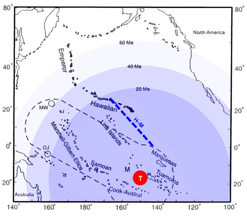
Fig. 3
Pacific
Island chains and related features, as modified from Figure 22 of
Keith, 2001.
The three dated circles show Keith’s proposed
contraction, from 60 million years ago (60 MA) to Recent time,
of a
hypothetical zone of outward flow and downwelling, a radial pattern
above an elongated lower-mantle plume (dashed outline),
and deduced
to represent a Mesozoic impact-triggered disturbance of the
steady-state mantle convective system.
Shown are the locations of
large plateaus of the comet, or asteroid, impact region,
with ages
of the oldest sediment, as follows:
Manihiki (M, 115-125 Ma),
Marcus-Wake Seamounts (MW, 90-115 Ma), and Ontong-Java (OJ, 100-125
Ma).
The peak of the persistent residual
plume corresponds to the broad South Pacific Superswell and South
Pacific Isotopic and Thermal Anomaly centered roughly at Tahiti
(T). Keith proposes that
the final stage of mantle/crust downflow is currently focused on an
elongated mid-Pacific zone (trend-line H-M) that extends from Hawaii
to the Marquesas. Keith identifies this as the residual trace
of a cold, depleted mass that developed below the ancestral
Mid-Pacific Ridge.
The South Pacific Isotopic and Thermal Anomaly (SOPITA)
mentioned in the captions for Figures 2 and 3 is defined not only by
relatively hotter mantle temperatures but by differing spatial
domains of concentrations of isotopes of lead, uranium, strontium,
and neodymium. These differing domains suggest that the Superswell
may be located over a stable, persisting zone of upwelling from the
lower mantle. Such upwelling may have been acting as a barrier since
at least the Cretaceous, separating two large mantle domains with
differing convective histories. The SOPITA data are believed to
require interactions between the deeper and shallower layers of the
mantle.
There is much more to Prof. Keith’s hypothesis for explaining
various features of the Pacific basin, but I know that you are
already bored to tears, reading so much unfamiliar terminology.
Suffice it to say that Keith makes the case for oceanic
island sinking within a surrounding zone of normal to low heat flow
and high seismic wave velocities that indicate mantle downflow
beneath the islands. What does this mean for the hypothesis of the
existence of Lemuria, or Mu?
On a much larger scale -
the scale of the SPS or even larger - we can postulate that in the
Cretaceous there was a continental-sized land mass above sea-level
in the Pacific basin. This was produced by an impact event. The
impact was sufficiently great to produce an enormous plume of
lower-mantle material that pushed up roughly beneath Tahiti. Then,
starting in post-Cretaceous time (about 60 Ma), as the crust and
outlying mantle cooled and contracted, the continent gradually sank
over the ensuing eons.
This sequence of events is similar to that which we reviewed in our
previous article on the Atlantic Basin. It’s just that the North
Atlantic geologic structure is the prime example of a
least-disturbed, steady-state mantle flow regime. The Pacific,
however, can be regarded as an extreme example of a disrupted
mantle-flow regime.
Archeological Evidence For Mu?
Is there any archaeological evidence of Lemuria? Maybe. Richard
Noone has written 10
about the presence of ancient construction works on two Pacific
islands, Malden in the Line Islands, and Rarotonga in
the Cook Islands chain. The two islands lie close to (Malden) or
just within McNutt’s boundary for the South Pacific Superswell.
(See Figure 2). Malden Island (4.00ºS,
155.00ºW) seems to contains the remains of a highway system that
radiates outward from a temple complex.
Composed of tight-fitting basalt blocks,
the roads cross beaches and disappear under the waves.
"Fifteen hundred miles south of
Malden Island, another section of the same type of road emerges
from under the waves, crosses the beach, and disappears into the
jungle of Rarotonga Island. This suggests that many
Pacific Islands are the remains of a presently submerged Pacific
continent"
(Noone, p. 198).
A
Conversation With Joan Griffith
I am pleased to have Joan Griffith, a long-term member of
A.R.E., drop by (electronically) to discuss her research of 64 years
running on the history of Mu, as found in the works of
Churchward and others.
WH: Joan, just when did you
come into contact with Churchward’s works?
JG: Col. Churchward (1851-1936) was a lifelong friend of
my father’s, from about 1880, when Dad was a boy. The Col. met
explorer Augustus Le Plongeon at my grandmother’s
Brooklyn townhouse; they compared notes on similarities of
ancient inscriptions, ruins, and sacred texts both of Maya and
Sanskrit or Pali in Yucatan and Tibet respectively, as my Father
listened intently.
I met the Col. only once as a young child, just before his death
in 1936. He seemed to know that I would be interested in
expanding upon his work in the future. I started reading
the Mu books that year; so you
see much of my life has focused on Atlantis, Lemuria, and
ancient knowledge that might have been lost thru the millennia.
In 60-plus years, much has been discovered that has supported
many of his claims. What isn’t generally known is that he
accessed hundreds of sources and listed over 140 ruins and
megalithic sites. This was not psychically-derived
information, though most of it tallied with what Edgar Cayce
later had to say on Mu/Lemuria.
WH: So you don’t think the jury is still out on whether
Mu existed?
JG: The sheer mass of detailed evidence that
Churchward compiled (five books just jammed full) presents
an overwhelming case for it. Since then, in the 1930’s,
soundings of the Pacific by Capt. Claude Banks Mayo of
the U.S. Navy show that there is "a submerged continent, with
mountains, river courses and plateaus at an average depth of one
mile stretching from the Hawaiian to the Barin Islands, east of
the coast of Japan."
WH: Do the Cayce readings mention anything about
Churchward’s research on Mu?
JG: No. It seems that no one asked Cayce about his work.
WH: You’ve read what I’ve written above. Would you like
to add anything to it?
JG: Yes. I’d just like to remind you that back in 1959
you wrote 11
about two studies that suggested early evidence of possible
ancient continent in the Pacific. One was by W.H. Menard,
an oceanographer. He wrote, in "Development of Median Elevations
in Ocean Basins" (1958, Geol. Soc. Amer. Bull., Vol. 69,
pp.1179-1186):
"The southern part of the east
Pacific Rise is 2000 km wide and 2 km high, one of the
largest oceanic rises in the world.... observations do not
rule out the possibility that broad rises may be temporary
features which are elevated and then subside."
And then there was the exciting
discovery of a vast layer of "clean white ash" on the Pacific
floor a few hundred miles from Central and South America,
extending 750 miles to the west and 825 miles to the south of
the equator (N.Y. Times of 4/12/59). E. Anders and D.N.
Limber ("Origin of the Worzel Deepsea Ash" in Nature,
Vol. 184) believe the ash to be of terrestrial, volcanic origin,
and that it must have "recorded a notable event in the Earth’s
history." This ash layer may have been related in some way to
Lemuria’s sinking.
WH: In my modest browsing of Churchward’s books I was
perplexed by his hypothesis of gas-belts crisscrossing the
world. Do you really think that explosions of underground
gas-filled chambers could have had anything to do with the
sinking of Mu? Where did he get his information?
JG: Churchward advanced a theory of gas-belts
crisscrossing the earth, and chambers between layers of granite
rock within the lithosphere. The formation and collapse of these
chambers, he averred, were responsible for the raising of
certain mountain ranges, volcanic eruptions, and sinking of land
masses. Churchward cites sources such as
the Troano
Manuscript, and old Egyptian writings that describe this
process. The logic of it appeals to me, although I am not an
expert in geology. It seems that science has caught up 80% to
his thesis.
No matter how it was destroyed, Lemuria won’t be swept under the
rug..... and the little chunks of evidence keep popping
up... Stanford University’s geophysicist Amos Nur, stated in 1977
that a "Pacifica" was a distinct probability, as crust centers
originate under continental masses, except in the Pacific, and
that "currently submerged plateaus in the ocean near Australia,
including the Minihiki plateau and the Ong-Java area, are
remnants of this past land mass."
Other explorers have found guyots (sea-mounts), one 11,000 ft.
high, under the Pacific waters.... since guyots can only be
formed by wave action, this is proof-positive such land sank,
and sank far.
And coral rings were discovered in the South Seas 1800 ft. deep.
So what does that mean? Coral cannot live in water greater than
150 ft deep, I’m told.
WH: What about archaeological finds from “Mu, the land of
the golden hills”? (Cayce reading 1472-1)
JG: Well, in French Polynesia.... marking the boundaries
of the Superswell (see Figure 2)..... are some of the most
thrilling megalithic ruins, in and out of the water... gigantic
stone walls, roads, platforms, pillars, 10 to 30-ton blocks
(illustrations & descriptions in John MacMillan Brown’s "Riddle
of the Pacific" and books on Lemuria & Pacific by
David Hatcher
Childress).
Who built these? In Rap Iti (French Poly) there are
coal deposits! Seems indicative of a once "high and dry" Pacific
Basin! Doesn’t it?
NOTE: Joan Griffith (James
Churchward's god-daughter, also the daughter of his best friend) has written a
more comprehensive article on Churchward’s findings and ideas in the
World Explorer magazine.12
References:
-
The Lost Continent of Mu, 1926
-
The Children of Mu, 1931
-
The Sacred Symbols of Mu, 1933
-
Cosmic Forces of Mu, in two
parts (1934-1935); and Books of the Golden Age, 1997.
-
Phylos the Tibetan, 1952, A
Dweller On Two Planets, Borden Pub. Co., Los Angeles.
-
Note that Edgar Cayce, America’s
most accurate and best-documented psychic, had something to
say about extraterrestrial beings. As T. Kay writes in his
book, When The Comet Runs, [1997, Hampton Roads Pub. Co.,
Charlottesville, VA., p. 146-147.]
-
"Few people are aware that
Cayce spoke of extra-terrestrials, on two occasions. In
a reading about the Atlantean period, he said: ’The
manners of transportation, the manners of communications
through the airships of that period were such as
Ezekiel
described of a much later date.’ (1859-1) .....
-
"In 1938 while discussing
the experiences of the people of the Mayan region who
occupied Central America, Cayce mentioned in passing:
’...and there were the beginnings of the unfoldments of
the understanding [from] those that were visiting from
other worlds or planets.’ (1616-1).
-
"It should be noted that
although Edgar Cayce spoke of UFO’s and
extraterrestrials, until the day he died he never once
in a reading or as a conscious individual wavered with
respect to the Christian teaching that Jesus Christ was
the Messiah and is ’The Way’ for all of humanity."
-
Randall-Stevens, H., 1966,
Camelot Press, London).
-
Reviews of Geophysics: v. 36,
no. 2, pp. 211-244. . [Dr. McNutt, a noted geophysicist, is
currently (4/01/02) president of the American Geophysical
Union (AGU), a scientific society with 15,000-members
worldwide].
-
Keith, M., 2001, “Evidence For A
Plate Tectonics Debate,” Earth-Science Reviews, 55.
-
5/5/2000, Ice The Ultimate
Disaster,1982, Three Rivers Press, New York.
-
Anonymous, 1959, Earth Changes,
Past-Present-Future, A.R.E. Press, Virginia Beach, VA. 23451
-
“James Churchward and His Lost
Pacific Continent,” 2002, World Explorer, v. 3, no.1, pp.
16-25.
|