|
from MarsAnomalyResearch Website
The report is about an Earth based scenario, a combination of the possibilities inherent in a background Earth story, some possible hypotheses by me, and then some visual evidence to add into the mix. It will be up to you to decide if there is any merit.
First we'll start with the background
story.
As the story goes, Plato's
references regarding Atlantis was allegedly in turn sourced from a
500 hundred years earlier 6th century BC trip by the Athenian
lawgiver Solon to Egypt where an Egyptian priest there translated a
part of an unknown history of ancient Athens and Atlantis from
papyri scrolls of Egyptian hieroglyphs to Greek of a time some 9,000
year earlier to that 6th century period.
It seems that in
the even more distant past, the "gods" divided up Earth lands among
themselves and Poseidon to his liking was assigned the then Atlantis
lands west off of the Pillars of Hercules which the latter we know
today as the Strait of Gibraltar separating the Atlantic Ocean and
the Mediterranean Sea.
Many have a problem with this because it is the
scientific consensus opinion that this location is geologically
impossible. Further, since science now days considers itself
rational and enlightened, the story starting off with the "god"
Poseidon likely causes many not to take it serious and regard it as
little more than fabricated myth.
The consensus also makes the assumption
that such records are not history but merely fabricated myths and
legends to explain events they didn't understand by ancient people
less sophisticated and knowledgeable than ourselves. In my opinion,
such views reveal more about our flaws and arrogance than ancient
ones.
One of these mountains
where Cleito apparently resided was carved by Poseidon into a great
palace with concentric rings of land, walls, and canals extending
out from its center and complete with other canal systems. It seems
that the eastern most and other reaches of the Atlantean world were
separate kingdoms divided up almost certainly among Atlas's brothers
and so the Atlantean world was a confederation of kingdoms with
Atlantis as its power center.
At some point in time not too long
after this Atlantean military defeat there is suppose to have been
some kind of earthquake upheaval that in one day and night caused
the whole of the Atlantean world to sink beneath the Atlantic Ocean
causing mud to poor in on top of it creating an impassable and
unsearchable muddy shoal and a hazard to navigation.
So if the one record is destroyed, the account is lost forever. So this is a no doubt condensed Egyptian account/record further condensed by Solon, further condensed by Plato, and further condensed and interpreted by people like me in more recent times so that much information and, more important, a true sense of elapsed time is lost and/or distorted.
So there may be a tendency to think about
this account happening in shorter lengths of condensed time than may
have actually been the case.
Logically, over the centuries earthquakes and rising sea levels may
have alerted many intelligent advanced Atlantean people to their
island life peril and especially among the island kingdoms with
lower elevations.
That would make sense with a broad area of
islands in the mid Atlantic making island hopping or circumventing
navigation westward to the Americas much easier.
Even if the Egyptian
account is false and a creation by Plato or his predecessors, it
still suggests a navigation knowledge of the Atlantic Ocean to its
western boundaries by some Mediterranean people in 355-360 BC and/or
before Plato's time and that too is significant.
That means that 12,000 year ago from our time the Atlantean culture
would be facing a warming trend that would have been ongoing and
well along for some 8,000 years with melting ice sheets and sea
levels rising nearing to the completion of this warming cycle just
2,000 years in their future.
That means that a great deal of the top of those mountain ranges
east of the Mid-Atlantic Ridge plate tectonic seam would have likely
been sticking considerably out of the water forming a massive area
of islands with many of them land interconnected and suitable for
habitation.
As their island centers were threatened by rising water levels and increasingly made more and more vulnerable to the occasional earthquake driven tsunamis and other rogue waves from deeper water over the centuries, there would have logically been a migration from this home area by many while others stayed behind unwilling to leave so typical of human behavior. This would explain the view of Atlanteans moving east by Egyptian and Greeks as invaders.
Did you know that Egyptian earliest history includes accounts of battles fought with unidentified peoples from the west?
The Atlanteans on the move, but being a finite number of people without the replenishment reserves of an long term established people and even with more advanced technology, they would gradually have been worn down in conquering ability pushing east into western Europe and Africa until finally exhausted they met their match and perhaps were stopped by the Athenians and a growing culture that later produced the fiercely committed Spartan defenders at Thermopylae.
If so, now all that is left of their legacy is
perhaps some of their DNA in many of us and some long lasting
megalithic structure evidence in Europe and Africa as their smaller
numbers were eventually absorbed into the greater human whole of
that part of the world.
In other words, I
suspect there is core truth to be had somewhere in this story.
However, I did
find what clearly appears to be some evidence of artificial
construction underwater west southwest well out from the Strait of
Gibraltar.
However, recently I received an email bringing this site back to my attention from a Clinical Psychologist Dr. Christof Lehmann wanting to know what I thought of the same underwater formations. I'm glad he did.
Now let's look at some Google imaging showing the location of the site and the site itself.
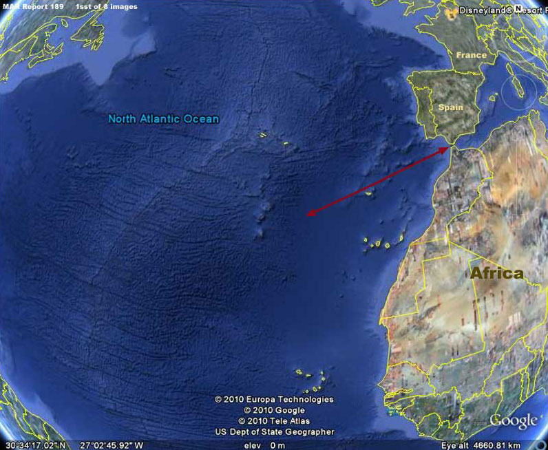
The above 1st image is a context view showing the Atlantic Ocean, the position of the unstable Mid-Atlantic Ridge tectonic plate fracture zone and the rough mountainous underwater terrain produced by it.
Likewise, the red arrow demonstrates the underwater evidence site to the left relative to the Strait of Gibraltar or Pillars of Hercules to the right at the mouth of the Mediterranean.
As you can see, the placement of the site is in general consistent with the ancient story of the placement of the Atlantean empire.
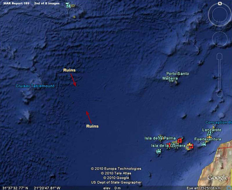
The above 2nd image from Google Earth provides a closer but still context view showing a little more detail of the evidence that surrounds the site.
Note that the site in question appears to be underwater on the east edge of the rough mountainous Mid Atlantic Ridge terrain and on the west edge of a more level plain. However, one needs to be cautious. This may or may not be accurate as a portion of the smoother plain appearance may also be the result of smudge treatments applied to the local area.
In fact, if one takes into consideration image tampering treatments, what we can see of the underwater ruins may merely be only part of a greater whole hidden by smudge treatments.
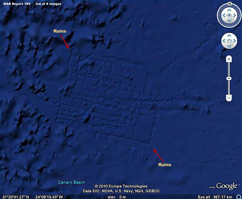
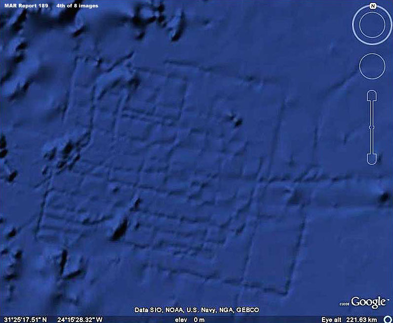
The above 3rd and 4th images provide different types of views of the underwater ruins site.
As you can see these many geometric right
angle and linear lines are almost certainly represent artificially
created ruins of some kind. However, note that there are apparently
no concentric round rings as the story describes that are suppose to
be on the main island of Atlantis. Further, while there are other
long linear lines east of this site that could be old ancient canals
connecting islands, there is no more evidence of ruins this
definitive in the immediate surroundings.
The ruin
outlines you see above are also how this site would look if smudge
image tampering were a factor. Same with the extensive smooth plain
to the east of this site. You can take nothing for granted in this
regard as to what role image tampering may play by hiding evidence.
However, what it does tell us is that what we have here is artificial ruin outlines underwater on the bottom of the Atlantic Ocean where none should exist and that alone is very significant. Scientists tell us that this is impossible but here you have the visual evidence.
Unless some advanced aliens built something here
underwater that has been covered over by smudge treatments and still
printing through them, we're almost certainly looking at ancient
human civilization construction evidence that had to have been
created by ancients over time and unquestionably out of water. That
means that this site existed at one time in the past out of water
and on dry land.
That in turn makes the story of
some ancient civilization like the Atlantean culture in the Atlantic
Ocean off of the Pillars of Hercules more feasible.
On the other hand, warming trend rising water levels would
have made islands more vulnerable to inundation at the same time
that increasing downward weight pressure of the rising water on the
Mid-Atlantic Ridge geologically unstable area could have created a
subterranean collapse of the plate dropping down a bit and/or a
significant earthquake displacing and pushing water in a great wave
over the already vulnerable island culture depositing swirling
stirred up bottom sediment (mud) over the area.
However, it was a part of something out here in this now
underwater terrain and there is no telling what extensive
civilization evidence may be hidden in this area under smudge
treatments. If there is anyone out there around the world with
access to commercial satellite imaging of this underwater general
area that may not have been subjected to tampering treatments,
please get it to me for examination and we'll see if there is
anything more to be seen here!
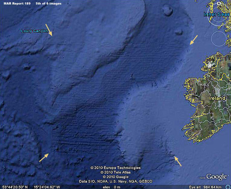
As it turns out, there actually is north of this area and off the west coast of Ireland and the visual evidence is as follows.
The above 5th image is the wide angle context view of that evidence both out on the coastal shallower water shelf represented by the lighter blue color and down in a deeper canyon system represented by the darker blue color.
Note that this evidence is not really like the ruins of buildings because the imprint of it is finer and closer textured but still with the sharp 90º right angle boundary geometry and long straight linear lines so typical of man's constructions.
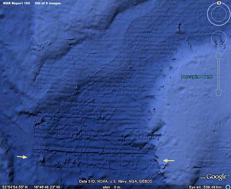
In the above 6th image, note the lower section pointed out between the two arrows.
This looks suspiciously like writing of some unknown kind, at least to me. IF this is writing, perhaps some better forensic imaging experts in conjunction with some linguist experts probably in ancient text could get better details and interpret this?
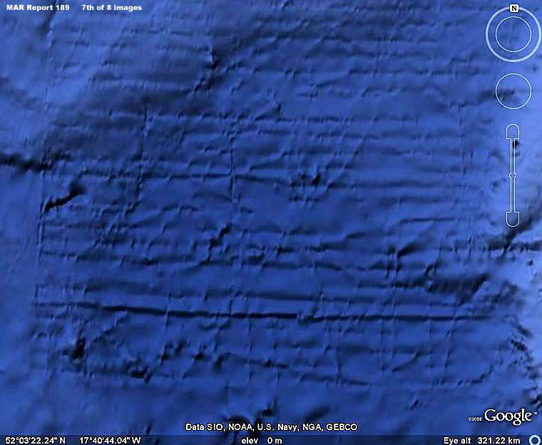
To that end, the above 7th image provides a closer view of this possible writing.
It also provides a good view of how precise the southern straight line boundary of this grid like site makes a perfect sharp 90º turn upward north forming the west boundary edge of the entire site. As you can see, the corner is just too right angle perfect to be the result of some natural occurrence and has been almost certainly implemented by artificial means.
As with the previous evidence, the presence of smudge and/or a mud covering on the site tells us that these are not imaging artifacts but something actually present on the bottom.
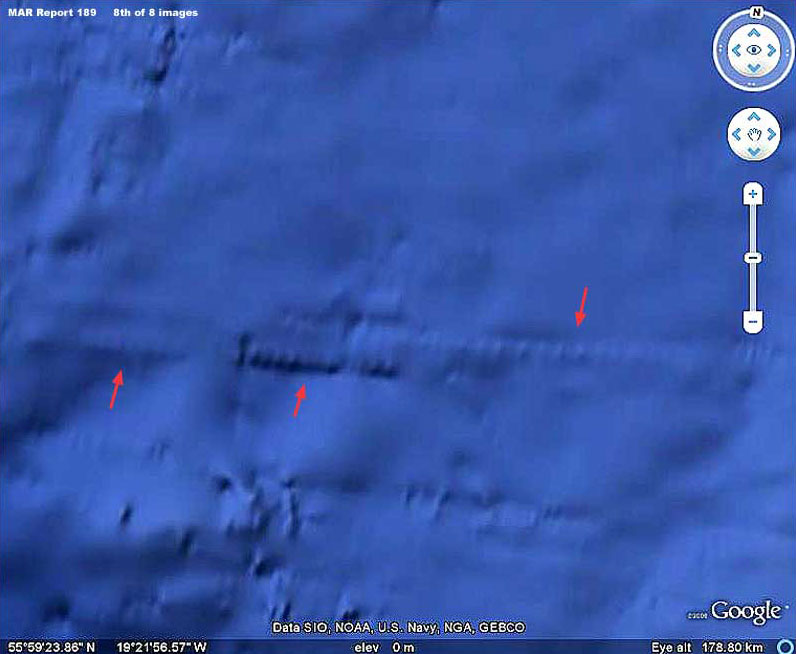
The above 8th image view is of the top or north and west boundary of the site off of Ireland.
As you can see, this area of the site is
more compromised by blur. That is caused I suspect mostly by
obscuring smudge treatments but acknowledge that it could be mud as
well. However, even so, note there are many objects (containers ?)
of the same size and in a side-by-side east/west orientation
repeating in a long uniformly even line here mostly but not
completely obscured and as pointed out by the red arrows.
What ever it is, the main
thing is that it appears to be of artificial origin and it is
underwater in the Atlantic off the west coast of Ireland. It is
entirely possible that this site also dates back into glacial
maximum times when the water levels here were at their lowest level
exposing this area to the air and sunlight enabling this
construction.
In other words, discoveries raising questions like this point to a time in this planet's history when things were happening that we in our ignorance in this time have little to no knowledge of today except for a few privy to truthful satellite imaging.
With that in
mind and consistent with human behavior, there may be a tendency to
speculate that these things were happening before our recorded
history? If so, let me say a word about that.
For example, the ancient libraries that we know were intentionally sacked and burned a number of times in the lands around the Mediterranean may have contained a great deal of this information. So much of the information in them was destroyed just because of the information they contained that someone of the time didn't want known.
So, with
the destruction, the information lost to human civilization is
incalculable. I might add that sadly much of that library
destruction was undertaken
in the name of religion and its
intolerance for difference.
They recorded a great deal of history on
gold likely thinking that the knowledge would never perish on this
wonderfully stable metal. They did not of course anticipate that
European white men driven by greed and accompanied by
zealot
guardians of religion would wish to destroy even history, covet the
gold, melt it down wholesale (again knowledge destroyed) too fill
great ship convoys headed back to Europe to feed even greater greed
and the power addicts of that time.
However, that's
just my personal thoughts.
At the same time it seems that Google has put forth an official
explanation found HERE that the evidence is a artifact of
bathymetric data collection sonar process from boats with the lines
reflecting the path of the boats. I was not aware either of the
prior discovery or the official explanation at the time of my
reporting above.
The subject of a
technologically advanced human civilization prior to our current
recorded history is not welcome in science or political consensus
circles just as it was not in ancient times with the destruction of
the great libraries. In this time it is preferred to promote
surprisingly advanced but still suitably and safely primitive
cultures like the Minoans in the Mediterranean as the bases for the
story of Atlantis.
However, no matter what they say, the evidence just isn't there.
That means that the official explanation amounts to no more than a
claim and it is clear that this site west off the Pillars of
Hercules has been specifically targeted for this special
explanation.
As for me, I stand by my reporting.
|