|
por admin Febrero 20, 2009 del Sitio Web RinconDelMisterio
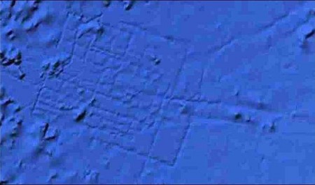
Navegando con Google Ocean el fondo del Atlántico, el ingeniero de aeronáutica Bernie Bamford, se encontró con un lugar cuadriculado ubicado a unos 5,5 kilómetros de profundidad, en un área llamado Madeira Abyssal Plane. Se muestra un rectángulo perfecto del tamaño de Gales en medio del Océano Atlántico.
¿Podría tratarse de la legendaria Atlántida?
Imagen de Google Ocean con el posible mapa de la Atlantida
Parece demasiado amplio y organizado para que sea algo de manera
natural. Y anoche la posibilidad de que fuese un extraordinario
descubrimiento ha revolucionado a los oceanógrafos y geofísicos.
Febrero 21, 2009
del Sitio Web
RinconDelMisterio Google acaba de informar que la extraña fotografía tomada a través de Google Ocean, que se especulaba podría tratarse de la legendaria Atlántida, es un error en el sónar y que no se trata de una serie de construcciones bajo el agua.
Debido al gran revuelo suscitado por está información, la multinacional informática tuvo que revisar sus datos y comprobaron que se trataba de un error en la medición hecha con barcos provistos de sónar que surcan el mar en línea recta, de ahí que apareciesen esas extrañas formas rectas en el fondo del mar.
Después de esto habrá que seguir buscando la Atlántida en otro sitio.
An Enormous
Construction Under The Sea February 20, 2009 from RinconDelMisterio Website
Sailing with Google Ocean the bottom of the Atlantic, the engineer of aeronautics Bernie Bamford, one was with a drawn into squares place located about 5.5 kilometers of depth, in a called area Madeira Abyssal Plane. Is as large as a perfect rectangle Wales in the middle of the Atlantic Ocean.
Could it be the legendary Atlantis?
Image of Google Ocean with the possible map of the Atlantis
It seems too ample and organized so that he is something of natural
way. And last night the possibility that it was an extraordinary
discovery has revolutionized to the oceanographers and
geophysicists.
February 21, 2009
from
RinconDelMisterio
Website
Due to the great commotion provoked by it is information, the computer science multinational had to review its data and verified that it was an error in the measurement done with provided boats of sonar that furrow the straight sea in line, for that reason they appeared those strange straight forms at heart of the sea.
After this we will have to continue looking for the Atlantis elsewhere.
|