|
Research and archaeological discoveries have, however, put her into the class that has a written history, vague it is true at present, at the same time beyond controversy. Every day something new is brought to light about Atlantis. Quite recently records have come to hand proving conclusively that Atlantis is not a myth.
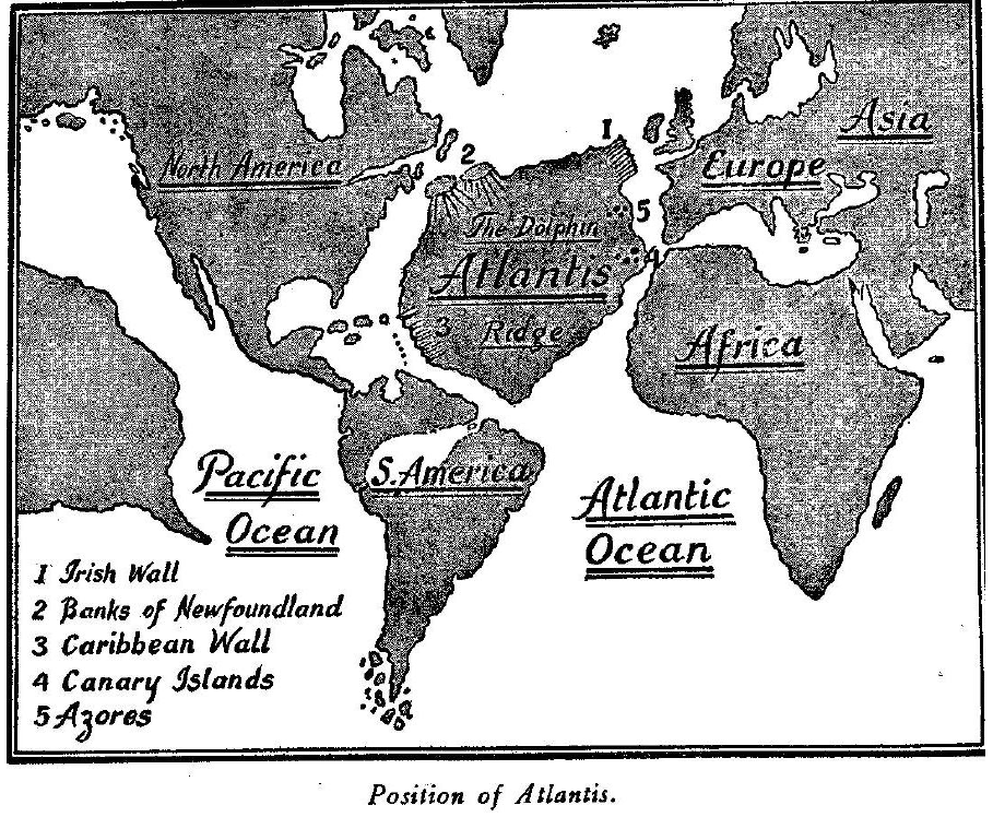
Atlantis was a large continent island situated in the North Atlantic Ocean with North and Central America to the west and Europe and northwest Africa to the east. Atlantis was in existence up to within a few thousand years ago.
Much light has been thrown on this great and important land of past history by the indefatigable work of Schliemann, to whom is due the honor for finally clinching the fact that Atlantis did once exist Plato 400 B. C. relates that Solon said!
Plutarch in his "Life of Solon" says:
Solon visited Egypt in 600 B.C. Atlantis sank 9000 years before. Add A.D. 2000 plus 9000 plus 600.
According to this record Atlantis sank 11,500 years ago, but I shall hereafter show that she did not sink to her present level for a long, long time afterwards. I found in an old Greek record that when Atlantis disappeared there were 3000 Athenian soldiers on her, probably an army of occupation. An Egyptian papyrus states that Poseidon was the first king of Atlantis and that he was followed by a long line of Poseidons, thus forming a Poseidon Dynasty.
The crown of Poseidon is shown as having three points, the numeral of the Motherland. His scepter was a trident, again showing Mu to be suzerain. The trident was the form of the Uighur scepter 20,000 years ago and later we find it as the scepter of the Khimers of Cambodia.
Le Plongeon found inscriptions in Yucatan stating:
In this respect Atlantis' fate was
a duplication of the fate of Mu.
The Sages referred to in this papyrus were the
Kings of Atlantis.
They reigned 13,900 years. Atlantis disappeared 11,500 years ago.
Therefore, Atlantis was governed by a king 25,400 years ago, that
is, Atlantis was a kingdom 25,400 years ago.
Another article from the treasures of Priam is a bird sphinx engraved:
To my mind, there is no question as to what and to whom this bird sphinx refers.
It shows the connection between Atlantis and Mayax.
It is an ornament, probably from a piece of statuary in Mayax
erected to the memory of Queen Moo. Queen Moo's totem was a macaw.
This sphinx has the body of a leopard and the head of a macaw. A
sphinx statue was erected in Mayax to Queen Moo's brother husband,
Prince Coh. Prince Coh's totem was a leopard. Prince Coh's piece of
statuary was a dying leopard and is now in the National Museum,
Mexico City.
This clears up two points in history:
The Troano MS. states that the first colonists who settled on the
delta of the Nile were Mayas. As the people came from Atlantis and
were Mayas, it shows that at least a part of Atlantis was peopled by
Mayas.
Some writers have confused in this sentence "lands beyond the sea" with "The Lands of the West" and from this assumed that Atlantis was Mu, the Motherland. I will correct this error before proceeding further. First I will quote what the priests of Egypt told Solon:
In one of the Oriental temples
there is a long history of Atlantis written 20,000 years ago.
THE GEOLOGICAL TALE OF ATLANTIS I will first take you to one of the most inaccessible valleys in Central Asia. In this valley springs one of the headwaters of the Brahmaputra River.
On a large spur from the main range of mountains there is a large secluded monastery. In this monastery there are a great number of very ancient tablets of clay. These tablets have been divided into sections, one of them being on geology and history, going back to the time before the foot of man trod the earth. They have an extended history of Atlantis with a queer map on a tablet about two feet square.
The map shows Atlantis with the contour of the lands around the Atlantic Ocean which are vastly different from today.
I will quote what struck me as being remarkable:
1. I am using the modern names of lands and seas so that anyone can
easily locate them.
I have added this bit of very ancient history to show my readers that one never knows what he is going to bring forth when pawing among old cellar-like holes with a foot of dust covering the floor.
It's like deep-sea fishing, you never know
what's going to take your hook, it's all a toss-up. Whatever
strikes, you haul it in. So, directly your fingers find something
solid in the dust, out it comes.
This plateau is known as the Dolphin Ridge. The location of this plateau is between 25 degrees and 50 degrees north latitude and between 20 degrees and 50 degrees west longitude. The Azores Islands are the tops of one of the submarine mountain ranges. At different points along the boundary of this submarine plateau there are perpendicular breaks or walls, thousands of feet in height, giving the appearance as if the roof of a house had fallen in leaving the walls standing.
Other parts of the
boundary are sharp declines like the flat roof of a house having
broken off on three sides and fallen leaving one side still attached
to the top of the wall.
From the Banks of Newfoundland, marked on the map, there is a southerly slope similar to the roof of a house with a very sharp pitch.
The bottom of the
Caribbean Sea is remarkable in itself. It looks as if in some past
time there had been a long, supporting wedge under the land keeping
it above water, the thick end having been towards the Atlantic
Ocean; that this supporting wedge was withdrawn, allowing the land
to sink below the level of the waters, leaving long broad stretches
of very shallow water over the thin end of the wedge, the shore line
waters today.
Fully four-fifths, if not more, of the
disturbed stratifications of rocks throughout the world could not
have been brought together in their present and confused state by an
upheaval. No such confusion and disturbance could be accomplished
except by the material falling.
My next step will be to show the cause of these
profound volcanic workings beneath the North Atlantic Ocean.
On the map, page 109, I have shown The Great Central Gas Belt as it runs from Mu, the Motherland to Asia Minor.
After passing under Mu in two parallels or divisions, it proceeds in an easterly direction under the Pacific Ocean until it reaches Yucatan and Central America. Both divisions split up into parallels before passing under America. The Northern passes under Yucatan, the Southern under Guatemala and Honduras. From America they pass out under the West India Islands. Here the parallels close in together again and form two trunk lines.
The Northern division
passes under the Atlantic Ocean to the Azores. There it splits into
several parallels. Leaving the Azores these parallels pass on and
enter Europe under Spain and Portugal. From the West India Islands
the Southern division proceeds under the Atlantic until it reaches
the Canary Islands, here it splits into parallels and enters Africa
near Morocco, forming the Atlas Mountains.
Neither are they at the same depth from the surface of the earth. The Southern is thousands of feet further down in the bowels of the earth and possibly miles. This difference in their depth is confirmed by the fact that when Atlantis was first submerged she only went down deep enough to be awash at low tide so that at low tide mud banks appeared with masses of seaweed which made the Northern Atlantic Ocean impassable to shipping.
This fact is
recorded in the temple histories
of Egypt. It was only after the
Southern division had been forged, which sank her to her present
level, that ships could again cross the Atlantic.
Had no isolated chambers been upholding Mu and Atlantis, there would have been a sufficient thickness of rock over the belt to have formed retaining angles when the gases escaped after uplifting the land.
Then these
continents would not have been submerged; instead, mountain ranges
would have been raised upon them.
The surrounding waters flowed in to fill up this hole, which drew off the waters from surrounding shores and from all shallow parts because a new lower level to the ocean was formed. Somewhere about this time in the earth's history the Appalachian-Iceland-Scandinavian Belt was formed. This belt commences in the Eastern Southern States, runs up through Labrador in Canada, from Labrador it passes under the Ocean to Greenland, Greenland to Iceland, and Iceland to Northern Europe, then to the Ural Mountains.
This belt has an immense number of ramifications.
The main belt is shown on the map as a broken line. Before this belt was formed there was no break in the land between America and Europe. They were connected by the submerged land shown in a shading and marked A, B and C.
This land is geologically known as "The
Overland Route to Europe." During the forging of this belt this land
bridge was broken up and parts of it submerged.
Does geology confirm this statement?
It certainly does and as prominent examples I will call attention to:
I have said that geology confirms my statements, so it does but in a
reverse way. Poor old geology, it has ever been guilty of putting
the cart before the horse. Geology is all right but only hitched up
the wrong way.
Geologists have apparently based these opinions on the many marine beaches found inland in Eastern North America.
These have been geologically called Champlain beaches. In Europe similar phenomena are found. The geological Champlain Period is a part of the Pleistocene. It was during the Pleistocene that the gas belts were formed and mountains raised and the great submersions of land took place, many stretches of land emerging which had been in shallow water.
When geology states that the present elevations of the Champlain beaches are solely due to the raising of the land, geology is in error.
Their
present positions are due to the work of two agencies: the first was
the lowering of the level of the oceans, the second was volcanic
workings elevating lands in the formation of the gas belt.
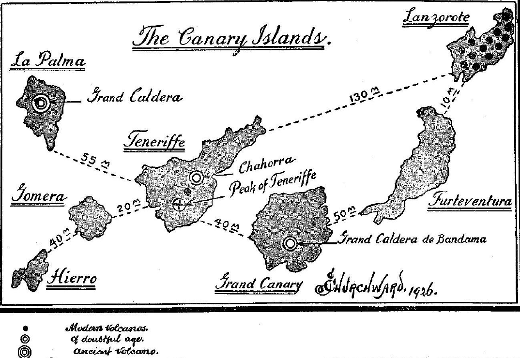
The Canary Islands lie over the Southern Atlantic division of the Great Central Gas Belt.
They are situated
off the northwest corner of Africa and distant from 60 to 120 miles.
They are directly opposite where the belt goes in under
Africa - Morocco.
By ancient, I mean they existed before the gas belts were formed and never had any connection with a gas belt.
Some of these ancient craters point directly to the submersion of Atlantis.
The volcano best known on the Canary Islands is the Peak
of Teneriffe whose snow-capped head pierces the blue sky at an
elevation of 12,000 feet. The ones, however, that are the most
interesting to me are: the Grand Caldera, La Palma Island, and the
Grand Caldera de Bandama, Grand Canary Island.
This crater is unquestionably an ancient one and has never been connected with any gas belt. It is the largest crater that I know of. Its diameter exceeds anything that is found among Pacific Islands. Ancient Kilauea, the monster on the Hawaiian Islands, measures three miles across its mouth while the mouth of the Grand Caldera is between four and five miles across.
The crater has a depth of between 6500 and 7000 feet. An examination of its sides discloses the fact that originally it was not of its present depth and the evidences tend to show that the drop from its original depth was not of a sudden character but took the form of a gradual subsidence. Personally, I believe that when the gases were exhausted and the sides fell together to seal it, the seal was loosely packed. Then time and subsequent earthquake shocks gradually packed and sank the surface to a lower level.
Being an ancient crater, one which was formed by
the escaping gases from a gas chamber when overcompressed, it is, to
my mind, one of the craters that helped to empty out the gases from
under Atlantis and then submerge her, that the Island of La Palma
was once a part of Atlantis.
The legend is:
It does not take much thinking to see
how this myth originated and the reason.
All other craters on the Canary Islands are
"modern," all being connected with the gas belt.
The Azore Islands in the North Atlantic Ocean lie directly west of Spain and Portugal.
The Northern division of the Great Central Gas Belt passes directly underneath them. As a matter of fact, the gas belt was the agent which emerged them. They are the tops of a submarine range of mountains that were raised above the water level. When Atlantis went down on the blow-out of the first gas chamber, this land was submerged. When the gas belt formed it raised this stretch of land into mountains, sending their tops above water level.
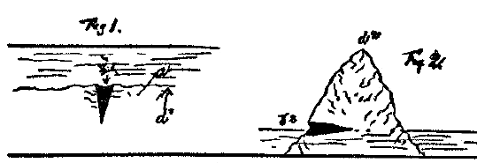
There is only one thing showing on the Azores that might possibly connect them with Atlantis: The Cavern Furna de Furnao Forge.
This cavern is the remains of an ancient crater that has been placed in another position from the original. What suggests itself to my mind is: this crater was one of many craters employed in emptying out the gases that were upholding Atlantis. When the roof fell it fell pretty flat around this area. Thus the crater would have maintained its original position vertical. (See Fig. I.)
Then when the belt was forming the gases found the least resistance to an uplift at d1.
The surface a was raised to position d2, thus throwing the crater b1, Fig.1, from a vertical to a horizontal position b2, Fig. 2.
In this position it became a cavern, entered from the side of the hill. In giving this little geological sketch I have only touched the high points. A detailed account could be given which would naturally consume a lot of space.
What I have shown, however, seems to me that
geology shows the one-time existence of Atlantis.
|