|
There it stood a vast continent of land next door to the Motherland, so to speak, yet not yielding a word about the Earth's First Great Civilization although adjoining lands, Central and North America, were full of records. To think that South America contained no such records seemed to me to be inconceivable, especially when we find both Oriental records and South Sea Island legends telling us that the children of the Motherland sailed all over the world in their ships.
If all over the world, South America being next door, then South America must certainly have been included and remains of the Earth's First Great Civilization had to be found there somewhere. But there she stood with me like a piece of a jig-saw puzzle that did not fit into my checker board of Man's First Great Civilization.
I was thrown off the scent by accepting the scientific reports about the Incas, which when gone into proved perfectly erroneous - the theories of untrained archaeologists.
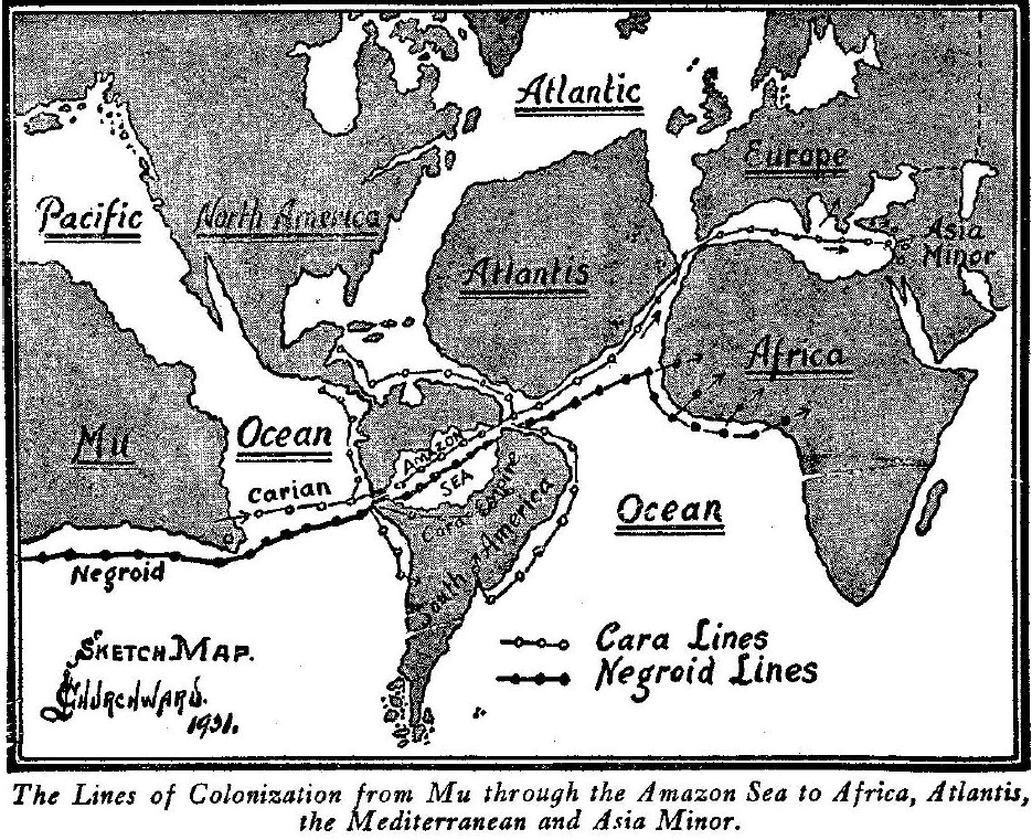
South America showing the ancient Amazon Sea and canals connecting
it with the Pacific Ocean from a tablet 25,000 years old in one of
the western monasteries of Tibet.
This map gave me a clue to many things I had
previously failed to understand. South America, although
unquestionably one of the richest archaeological fields on earth,
has yet to have the first archaeological sod turned on it.
Let us see what has been said about them because,
instead of being ancient, they are only of yesterday.
Peru is celebrated for her Inca civilization. The Incas were not a prehistoric people, nor can they even be classed as an ancient people.
The name Inca was taken from the name of their king or ruler who was called "The Inca." Previous to their election of a king, they were a mixed people. Among them were Quiches from Central America who emigrated to Peru from Guatemala and settled with the people who were occupying the land, who were called Aymaras.
The influx of the Quiches into Peru was of a friendly character, just as Europeans come to the United States today and settle down among us. The Inca Empire was not prehistoric, nor can it in any way be claimed as such. It was formed by a highly civilized people who had been shut in and unknown to the outer world up to four hundred years ago when they were discovered by the Spaniards through whom this great civilization was wiped out.
The Inca Empire commenced between
A.D. 900 and A.D. 1000 and ended with the Spanish conquest A. D.
1532, so that it lasted only about 500 years.
This myth intimates that the celestial orb had quite a large and interesting family in Peru. Another myth states that his mother was an unmarried woman of high family. Finding herself with child, she went and lived on one of the islands of Lake Titicaca to hide her shame until her son had reached manhood. She then came ashore with him and presented him to the people as being of divine conception, sent to be their King.
The people believed her tale and elected him
Inca.
Where they obtained this idea I cannot imagine. Both traditions and written documents state that it was a friendly colonizing similar to the European settlement of our country. Again, there were no Incas until Manco Capac was crowned; before that it was the Aymaras and Quiches.
When Manco Capac was crowned and called Inca both the
Aymaras and Quiches adopted the name of Inca in honor of their new
ruler.
This city when built was on a plain but a few feet above the level of the ocean. Since then the Andes Mountains have been raised and the city was carried up with them. There is a remarkable monolith covered with symbolical figures and writing at Tiahuanaco which I deciphered and translated in The Lost Continent of Mu. The characters are all what is called Maya. It shows when it was built.
That it was constructed at or near sea level is shown by various
marine shells in the neighborhood.
The same expression is used by Valmiki, the Hindu sage-historian; regarding the Naga Empire, he says:
That the structures around Lake Titicaca were built before the mountains were raised is not my opinion alone, for E.B. Enock, the great South American geologist, evidently has arrived at the same conclusion as is shown in his book on Peru.
If we can judge by what occurred in
other parts of the world where mountains were raised, it is
reasonable to assume that when the Andes went up nearly all of the
people of Peru were wiped out with a few survivors here and there.
Probably these survivors escaped to somewhere among the headwaters
of the Amazon and there fell into savagery, so that there is quite a
possibility that some of the savages who now occupy the headwaters
of the Amazon are the descendants of the builders of Tiahuanaco.
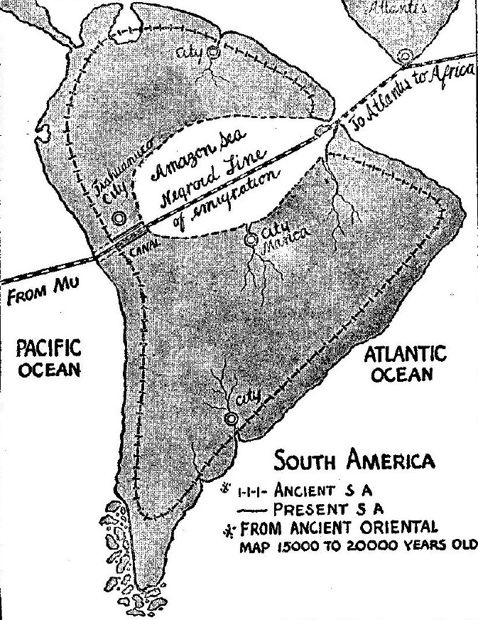
The Incas did not build these water courses or canals; they were built 16,000 to 18,000 years before the time of the Incas. They were ruins when the Aymaras first came to Peru, which was long before they became Incas. The present condition of these canals confirms the fact that they were built before the mountains were raised and when Peru was a low, flat country.
Instead of denuding the country of water, these canals were
waterways for ships to pass through.
Tiahuanaco is shown close to the canal. Other cities are shown on
the map including Manoa, the Golden City of legend.
The present-day Peruvians retain many of the ancient customs. Before drinking from a vessel, a few drops of the liquid are poured on the earth, and before eating anything solid a few crumbs are scattered on the ground as they repeat; "to Pacha-Mama," thus acknowledging to Mother Earth that all that sustains life comes from her. Here we have a shadow of the Motherland.
Mama is a word direct from the mother tongue. Mu means Ma and Ma or Mama means earth, depending on where and how used. A Peruvian legend relates that originally there was an empire around Lake Titicaca adjoining the Incas whose people were of another race called Chancas.
They came to Peru about 2000 years ago from the center of South America by way of the Amazon River and one of its branches.
These mountains surrounded the empire. They had a wonderful capital city which they called Manoa (Golden City). It would appear that this Chanca Empire was brought to its end by the Incas conquering and assimilating it.
The full legend appears in notes on Brazil.
When in Central America, I obtained various legends about
the Caras leaving Central America and going to the south where they
formed settlements on some great rivers. These legends referred to a
time more than 16,000 years ago. Let us consult the reports of
travelers and explorers in South America.
Here is a remarkable coincidence - a number of the Cara words are the same as the Pueblo Indian, intimating that at some ancient date they probably were geographically adjoined either here in America or in the Motherland.
Cacique is a prominent word in the Cara, the Pueblo and other Indian tribes. There is a race named Guaharibo living in the most inaccessible parts of the forests of southern Venezuela that has many of the characteristics of the lost tribe of Central America, those with the misshapen heads.
These people are reported
to be fierce and unapproachable, the worst savages of Venezuela.
When the first settlement was made by man in Brazil, the whole of the Amazon basin was an inland sea, a duplication of the Mediterranean.
There were no mountains between the Amazon and the Pacific Ocean. The Amazon basin only became a swamp after the great island of Atlantis was submerged. To fill up the immense hole in the Atlantic Ocean caused by the sinking of Atlantis, all surrounding waters were drawn in until a level was found. Where the waters were shallow the water was drawn off and the land emerged.
The waters of
the Amazon Sea were shallow, the waters were drawn off to such an
extent that only a huge swamp remained where once the Amazon Sea had
existed. Into the great inland Amazon Sea, many rivers flowed which
are now the arms and feeders of the great Amazon River.
A present-day Guatemalan tradition as related to me says:
This refers to a time more than 16,000 years ago.
Some time since Colonel Fawcett discovered in the center of Brazil, 1500 miles inland, between the headwaters of the Rivers Huigu and Tapajos, an ancient city. This part of Brazil is an immensely large unexplored region. The Rivers Huigu and Tapajos are the two principal southern branches of the Amazon. A few years ago Colonel Fawcett brought out a small statue across the breast of which was written an inscription. I saw it only for a few seconds.
The inscription, however, was easy to read as it was Cara Maya and not over 2000 years old. I think Fawcett must have run across the ruins of Manoa. Two of my friends who have been exploring this very region returned a short time ago. They found many remains, also the remains of the ancient bridge called Tia Chanca.
They tell me that about 500 to 600
feet remain intact. The roadway is 300 feet above the ground.
The Chancas were conquered by the Incas and their country annexed.
The time is given from their arrival at Titicaca to the time they
were conquered by the Incas, but as the time is computed by
generations and the years of a generation are not given, the length
of time in years cannot be given, probably about a thousand years.
Some prehistoric ruins are to be found on the banks of
the River Platte, Argentina. Some time since a tablet was found in
these ruins with an inscription which was discovered to be an exact
duplication of one found in Mongolia, Asia.
Find the fact and history will be enriched.
And now, to me, comes the most fascinating part of South American history - the distant past.
Strange as it may appear to us today, the fact remains that in ancient times South America played an important part in peopling the world, for she was the road or passageway that two important lines of colonists took going from the Motherland in easterly directions.
The topography of South America today is totally! different from what it was 20,000 years ago, the time when droves of Carians, or Karians, and Negro colonists were leaving the Motherland to find new homes and more room upon the earth. When this exodus from the Motherland commenced we have not as yet been told, but there are various records of emigration some 35,000 years ago and others 70,000 years ago.
Then
South America was like the rest of the world - flat and without
mountains - for up to less than 15,000 years back no mountains had
been raised to protect man from constant destructions by cataclysms
and submersions, nor could there possibly be until after the earth
went into Final Magnetic Balance.
The Amazonian Sea at its eastern end was connected with the Atlantic Ocean and at its western end with the Pacific Ocean by canals. These canals were intact up to the time the mountains were raised. There was an uninterrupted waterway between the Motherland and Atlantis, West Africa, and even as far as Asia Minor at the eastern end of the Mediterranean. The shore lines of this Amazonian Sea are very distinctly marked today: the northern shores were along the foothills of the Venezuelan highlands; along this shore line are some wonderful white quartz beaches.
The southern shores are along
the foothills of the Pan Alto Mountains. The eastern shores are
along a mountainous spur that runs into the Pan Alto, and the
western shores are along the eastern foothills of the Andes.
It bears a name which reads:
The third city was situated about half way along the southern shore but a little inland and was called "The City of Gold," without doubt the legendary Manoa.
Another one lay far south on the sea coast about, I think, where the
River Platte is today. No name is given to it. Still another lay to
the north of the Sea. From its position I should think somewhere in
Venezuela. There is no name given to this one either. The
inscriptions at various spots show that these cities were built by Carians or Karas.
Either this kingdom or a successor was in existence up to
within 1500 years ago.
She lived, according
to the Troano MS., 16,000 years ago. The Carians still persist along
the Central American States. They are not pure-blooded, however;
they have been very much mixed with Negro blood and generally are in
a degraded state. The Caribbean Sea was named after the Carians.
One tribe or set called themselves Athenians. From Egypt we learn that one of the Athenian capital cities, ancient Athens, was destroyed by earthquakes and submerged 11,500 years ago, about the same time that Atlantis was submerged. The Egyptians further tell us that ancient Athens was built 17,000 years ago. From the time of the destruction of ancient Athens, we hear nothing of the Carians in history until about 1104 B.C. (The First Olympiad.) Their descendants are now known as the Greeks.
Some of their old philosophers boasted of their Carian descent. Herodotus claimed to be a Carian.
Among the ruins of this city there is a wonderful monolith called by archaeologists,
It is completely covered with
inscriptions, most of which are Cara-Maya. The stone, as I have
shown by its deciphering and reading in the companion book to this,
The Lost Continent of Mu, is about 16,000 years old.
It was formed by crossing the hieratic letter N
This was a
diphthong pronounced Sh. In the present-day Hindu language, all
words commencing with Si are pronounced She. As an example Siva is
pronounced Sheva, The brown-skinned savages who occupy this region
(the Matto Grosso) today call all whites Caraibas. This certainly
comes out of Carib, showing that these savages know the color of the
men who occupied the land before them.
Civil wars so reduced and weakened the people and country that they became a tempting morsel and an easy prey to the surrounding warlike tribes. The men were wiped out by their enemies and the fairest of the women only were let to live and these became the slaves of their conquerors. In Peru I came across an old Chanca legend.
The legend says:
According to this legend the great war between the two brothers was
fought "thirty generations ago." How many years constituted a
generation is not said, and the generations have to be counted back
from about A. D. 1500.
It appears to me that to complete the tale about the Carians, I shall have to include that mysterious little speck of land, Easter Island, which stands all by its lonesome out in the middle of the great Pacific Ocean and which apparently was so intimately connected with the Carians in the infinite days that are past.
The history, such as it is, of Easter Island is given in The Lost Continent of Mu. I reserved the following for this work as it appears to me to be a shadow of a connecting link between the Easter Island statuary, the puzzle of the scientific world since the discovery of the island, and the Carians. A little colored boy asked another little colored boy, who was eating a slice of watermelon, to leave a piece of the rind for him.
The boy eating answered:
This section is on Easter Island, but like the boy eating the watermelon, I will say:
What is now Easter Island was then a part of the
great continent of Mu, man's Motherland.
Who were the people who carved the Easter
Island images? And what has become of them?
First let us marshal what facts there are and lay them out in order and see to whom they point. The Tibetian ancient tablet map shows that in ancient times there were no mountains and that which is now the Amazon River Valley was then a land-locked Sea. The canals referred to in South America lie directly opposite to Easter Island, then Easter point and port.
A tribe of colonists left the Motherland from Port Easter and migrated east as far as Asia Minor. They were called sometimes Karas, sometimes Carians. Their remains and records are to be traced from the western shores of South America, through the Amazonian Sea, on to, and including, Asia Minor. The southeastern parts of the Motherland was the Carian country.
This would have included what is
now Easter Island.
The method of quarrying these stones is peculiar to these two stones only, as far as I know, and I might say most unusual; for instead of being brought out in the rough and tooled in the open they are cut, carved and finished in horizontal positions lying in pits out of which they have to be lifted. How did the ancients lift a 70 foot monolith out of a pit? And how did they lift a 1200 ton stone out of a pit and transport it to the top of a hill and there set it up?
These are questions for
our mechanical engineers to answer, it's beyond me.
This is true, but some thousands of years
transpired between the two carvings. The Easter Island statuary was
carved before the mountains were raised, and the Baalbek work was
done after the mountains were raised.
The thought impinges itself on me that possibly during the
destruction of Mu, when the land was being torn to pieces by
earthquakes, great cataclysmic waves rolled in over Easter Island
and drowned all the inhabitants.
Two of the most puzzling questions I've had to solve to be the slightest bit satisfied with my work was to tell how Negroes got to Atlantis and how Negroes got to Africa.
Two facts had to be faced: Fact One, all the earth was peopled from Mu, the Motherland. Fact Two, the home of the Negro in the Motherland was at the southwest corner of Mu which is now represented by various clusters of islands called Melanesia and here today are Negroes, descendants of those who were saved when Mu was engulfed. The Tibetian tablet map answers the questions, the inhabitants of the Melanesian Islands prove it.
We must first differentiate between the two typical black-skinned races of Africa.
One of the characteristics of the children of the Motherland was that, when they emigrated or went on long journeys, they invariably selected all water routes.
As will be seen by the accompanying map, there was a clear unimpeded all-water route from the Motherland to Africa and Asia Minor by way of the Amazonian Sea. The Negroes and Negroids coming from the southwest corner of Mu would skirt the coast until they came to Easter Island Point. From there they would cross over to the American canals, then through the Amazonian Sea to the Atlantic Ocean.
On arriving at the Atlantic they would make for
the lower point of Atlantis. From this point they could go directly
east and strike the shores of Africa a little north of Nigeria; or
they could follow the coast line of Atlantis as far north as the
Canary Islands where they would be only 70 miles from the African
coast
Valmiki, the Hindu sage-historian, writing from ancient temple records, said:
It
was more than 30,000 years ago that India was turned from a colony
into a colonial empire.
Subsequently the Tibetian map
answered the question - they came through the Amazonian Sea,
therefore, never touched Central or North America.
The Zulus have a tradition that,
To make the record complete this question should be answered.
The answer is: because the water was drawn out of it by the lowering of the level of the Atlantic Ocean. This necessitates the answering of another question: why was the level of the Atlantic Ocean lowered?
Answer: Atlantis was submerged; this made a great hole in the Atlantic Ocean, thousands of miles from east to west and thousands of miles from north to south and thousands of feet deep.
To fill up this hole and level off the waters again, the water had to flow in from all sides. So much was drawn in that it resulted in lowering the level of the ocean hundreds of feet. The lowering of the level of the Atlantic Ocean drained out the Amazonian Sea, the Mississippi Valley and the St. Lawrence Valley.
It emerged Florida and extended the coast lines
on both sides of the Atlantic, and a few other interesting little
things that have escaped the notice of geologists. Return to Messages From Andean and American Civilizations
|
 (Fig. 1.) of the Motherland's alphabet (Fig. 2.).