|
Contents
-
English Version
-
Version en Español
Tikal
from
Wikipedia Website
Tikal (or Tik’al according to the modern
Mayan orthography) is one of the largest archaeological sites and
urban centers of the pre-Columbian Maya civilization.
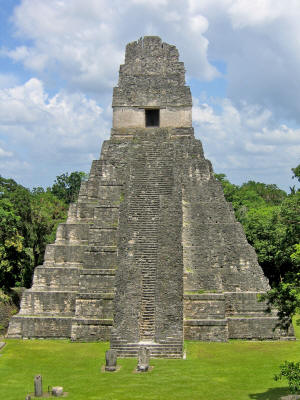
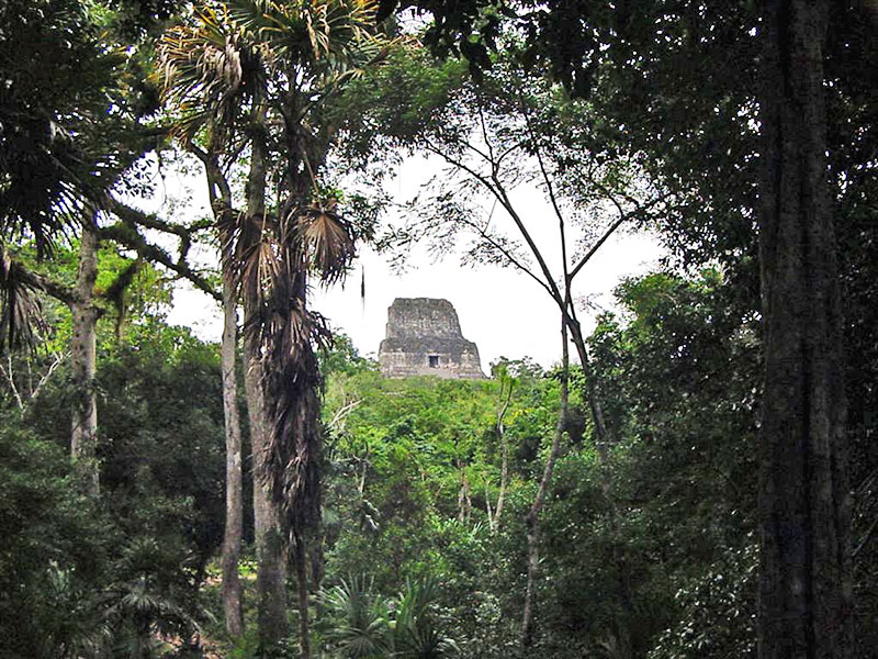
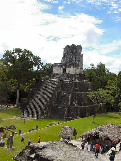
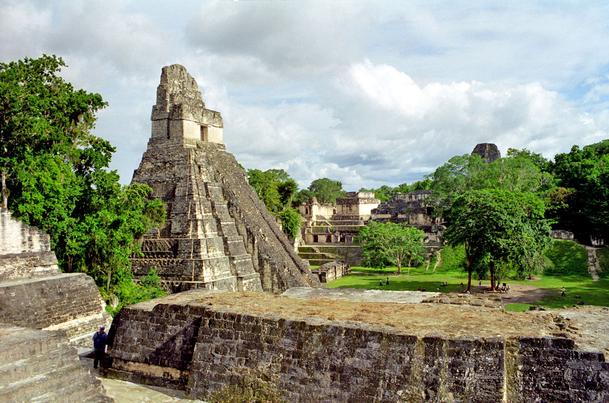
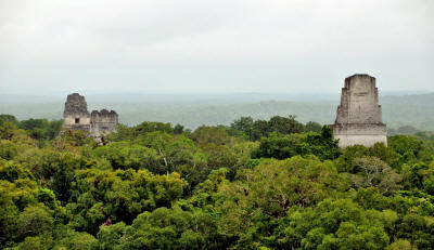
Tikal Temple I rises
47 meters (150 ft) high.[1]
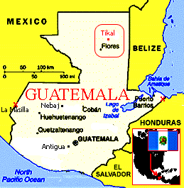
It is located
in the archaeological region of the Petén Basin in what is now
modern-day northern Guatemala. Situated in the department of El
Petén, the site is
part of Guatemala's Tikal National Park and in
1979 it was declared a UNESCO World Heritage Site.[2]
Tikal was the capital of a conquest state that became one of the
most powerful kingdoms of the ancient Maya.[3] Though
monumental architecture at the site dates back as far as the 4th
century BC, Tikal reached its apogee during the Classic Period, ca.
200 to 900 AD.
During this time, the city dominated much of the Maya
region politically, economically, and militarily, while interacting
with areas throughout Mesoamerica such as the great metropolis of
Teotihuacan in the distant Valley of Mexico.
There is evidence that Tikal was
conquered by Teotihuacan in the 4th century AD.[4]
Following the end of the Late Classic Period, no new major monuments
were built at Tikal and there is evidence that elite palaces were
burned. These events were coupled with a gradual population decline,
culminating with the site’s abandonment by the end of the 10th
century.
Tikal is the best understood of any of the large lowland Maya
cities, with a long dynastic ruler list, the discovery of the tombs
of many of the rulers on this list and the investigation of their
monuments, temples and palaces.[5]
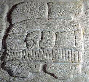
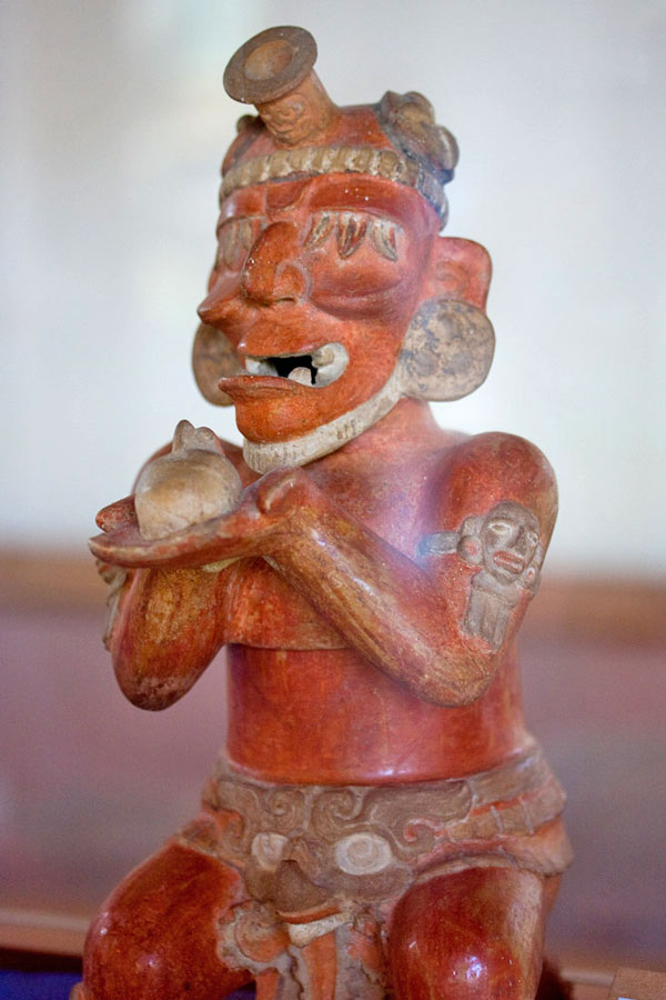
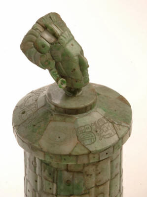
Emblem Glyph for Tikal (Mutal)
Etymology
The name Tikal may be derived from ti
ak'al in the Yucatec Maya language; it is said to be a relatively
modern name meaning "at the waterhole". The name was apparently
applied to one of the site's ancient reservoirs by hunters and
travelers in the region.[6]
It has alternatively been interpreted as
meaning "the place of the voices" in the Itza Maya language. At any
rate, Tikal is not the ancient name for the site but rather the name
adopted shortly after its discovery in the 1840s.[7]
Hieroglyphic inscriptions at the ruins refer to the ancient city as
Yax Mutal or Yax Mutul, meaning "First Mutal".[6]
Tikal may have come to have been called
this because Dos Pilas also came to use the same emblem glyph; the
rulers of the city presumably wanted to distinguish themselves as
the first city to bear the name.[8]
The kingdom as a whole was simply called
Mutul,[9] which is the reading of the "hair bundle"
Emblem Glyph seen in the accompanying photo above. Its precise meaning
remains obscure,[6] although some scholars think that it
is the hair knot of the Ahau or ruler.
Location
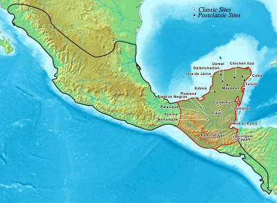
Map of the Maya area within the Mesoamerican region.
Both Tikal and Calakmul lie near the centre of the area.
The closest large modern settlements are Flores and Santa Elena,
approximately 64 kilometers (40 mi) by road to the southwest.[10]
Tikal is approximately 303 kilometers (188 mi) north of Guatemala
City. It is 19 kilometers (12 mi) south of the contemporary Maya
city of Uaxactun and 30 kilometers (19 mi) northwest of Yaxha.[6][11]
The city was located 100 kilometers (62
mi) southeast of its great Classic Period rival, Calakmul, and 85
kilometers (53 mi) northwest of Calakmul's ally Caracol, now in
Belize.[12]
The city has been completely mapped and covered an area greater than
16 square kilometers (6.2 sq mi) that included about 3000
structures.[13]
The topography of the site consists of a
series of parallel limestone ridges rising above swampy lowlands.
The major architecture of the site is clustered upon areas of higher
ground and linked by raised causeways spanning the swamps.[14]
The area around Tikal has been declared as the Tikal National
Park and the preserved area covers 570 square kilometers (220 sq
mi).[15]
The ruins lie among the tropical rainforests of northern Guatemala
that formed the cradle of lowland Maya civilization. The city itself
was located among abundant fertile upland soils, and may have
dominated a natural east—west trade route across the Yucatan
Peninsula.[16]
Conspicuous trees at the Tikal park
include:
-
gigantic kapok (Ceiba pentandra) the sacred tree of the
Maya
-
Tropical cedar (Cedrela odorata)
-
Honduras Mahogany (Swietenia
macrophylla)
Regarding the fauna, agouti, white-nosed coatis, gray
foxes, Geoffroy's spider monkeys, howler monkeys, harpy eagles,
falcons, ocellated turkeys, guans, toucans, green parrots and
leafcutter ants can be seen there regularly.
Jaguars, jaguarundis, and cougars are
also said to roam in the park. For centuries this city was
completely covered under jungle. The average annual rainfall at
Tikal is 1,945 millimeters (76.6 in).[17]
One of the largest of the Classic Maya cities, Tikal had no water
other than what was collected from rainwater and stored in ten
reservoirs. Archaeologists working in Tikal during the 20th century
refurbished one of these ancient reservoirs to store water for their
own use.[18]
The absence of springs, rivers, and
lakes in the immediate vicinity of Tikal highlights a prodigious
feat: building a major city with only supplies of stored seasonal
rainfall.
Tikal prospered with intensive agricultural techniques,
which were far more advanced than the slash and burn methods
originally theorized by archaeologists. The reliance on seasonal
rainfall left Tikal vulnerable to prolonged drought, which is
thought by some to have played a role in the Classic Maya Collapse.
The Tikal National Park covers an area of 575.83 square kilometers
(222.33 sq mi). It was created on 26 May 1955 under the auspices of
the Instituto de Antropología e Historia and was the first
protected area in Guatemala.[19]
Population
Population estimates for Tikal vary from 10,000 to as high as 90,000
inhabitants, with the most likely figure being at the upper end of
this range.[13]
Because of the low salt content of the Maya diet, it
is estimated that Tikal would have had to import 131 tons of salt
each year, based on a conservative population estimate of 45,000.[20]
The population of Tikal began a continuous curve of growth starting
in the Preclassic Period (approximately 2000 BC - AD 200), with a
peak in the Late Classic with the population growing rapidly from AD
700 through to 830, followed by a sharp decline. For the 120 square
kilometers (46 sq mi) area falling within the earthwork defenses of
the hinterland, the peak population is estimated at 517 per square
kilometer (1340 per square mile).
In an area within a 12 kilometers (7.5
mi) radius of the site core, peak population is estimated at
120,000; population density is estimated at 265 per square kilometer
(689 per square mile).
In a region within a 25 kilometers (16 mi)
radius of the site core and including some satellite sites, peak
population is estimated at 425,000 with a density of 216 per square
kilometer (515 per square mile). These population figures are even
more impressive because of the extensive swamplands that were
unsuitable for habitation or agriculture.
However, some archaeologists, such as
David Webster, believe these figures to be far too high.[21]
Rulers

|
Name (or
nickname)[23][24] |
Ruled |
Dynastic
succession no. |
Alternative Names |
|
Yax Ehb' Xook |
c.
90 |
1 |
Yax Moch Xok,
Yax Chakte'l Xok, First Scaffold Shark[25] |
|
Foliated Jaguar |
c.
292 |
? |
- |
|
Animal Headdress |
? |
10? |
Kinich Ehb'? |
|
Siyaj Chan K'awiil I |
c.
307 |
11 |
- |
|
Lady Une' B'alam |
c.
317 |
12? |
- |
|
K'inich Muwaan Jol I |
? -359 |
13 |
Mahk'ina Bird Skull,
Feather Skull |
|
Chak Tok Ich'aak I |
360-378 |
14 |
Jaguar Paw, Great
Paw, Great Jaguar Paw |
|
Yax Nuun Ayiin I |
379 -404? |
15 |
Curl Snout, Curl
Nose |
|
Siyaj Chan K'awiil
II |
411-456 |
16 |
Stormy Sky, Manikin
Cleft Sky |
|
Kan Chitam |
458-c. 486 |
17 |
Kan Boar, K'an Ak |
|
Chak Tok Ich'aak II |
c.
486-508 |
18 |
Jaguar Paw II,
Jaguar Paw Skull |
|
Lady of Tikal |
Kaloomte' B'alam |
c.
511-527+ |
19 |
Curl Head |
|
Bird Claw |
? |
20? |
Animal Skull I |
|
Wak Chan K'awiil |
537?-562 |
21 |
Double Bird |
|
Animal Skull |
c.
593-628 |
22 |
- |
|
K'inich Muwaan Jol
II |
c.
628-650 |
23 or 24 |
- |
|
Nuun Ujol Chaak |
c.
650-679 |
25 |
Shield Skull, Nun
Bak Chak |
|
Jasaw Chan K'awiil I |
682-734 |
26 |
Ruler A, Ah Cacao |
|
Yik'in Chan K'awiil |
734-c. 766 |
27 |
Ruler B, Yaxkin Caan
Chac, Sun Sky Rain |
|
Ruler 28 |
c.
766-768 |
28 |
- |
|
Yax Nuun Ayiin II |
768-c. 794 |
29 |
- |
|
Nuun Ujol K'inich |
c.
800? |
30? |
- |
|
Dark Sun |
-810+ |
31? |
- |
|
Jewel K'awiil |
-849+ |
? |
- |
|
Jasaw Chan K'awiil
II |
-869+ |
? |
- |
|
History
Preclassic
There are traces of early agriculture at the site dating as far back
as 1000 BC, in the Middle Preclassic.[26] A cache of
Mamon ceramics dating from about 700-400 BC were found in a sealed
chultun, a subterranean bottle-shaped chamber.[27]
Major construction at Tikal was already taking place in the Late
Preclassic period, first appearing around 400-300 BC, including the
building of major pyramids and platforms, although the city was
still dwarfed by sites further north such as El Mirador and Nakbe.[26][28]
At this time, Tikal participated in the widespread Chikanel culture
that dominated the Central and Northern Maya areas at this time - a
region that included the entire Yucatan Peninsula including northern
and eastern Guatemala and all of Belize.[29]
Two temples dating to Late Chikanel times had masonry-walled
superstructures that may have been corbel-vaulted, although this has
not been proven. One of these had elaborate paintings on the outer
walls showing human figures against a scrollwork background, painted
in yellow, black, pink and red.[30]
In the 1st century AD rich burials first appeared and Tikal
underwent a political and cultural florescence as its giant northern
neighbors declined.[26]
At the end of the Late Preclassic, the
Izapan style art and architecture from the Pacific Coast began to
influence Tikal, as demonstrated by a broken sculpture from the
acropolis and early murals at the city.[31]
Early Classic
Dynastic rulership among the
lowland Maya is most deeply rooted at Tikal. According to later
hieroglyphic records, the dynasty was founded by Yax-Moch-Xoc,
perhaps in the 3rd century AD.[32]
At the beginning of
the Early Classic, power in the Maya region was concentrated at
Tikal and Calakmul, in the core of the Maya heartland.[33]
Tikal may have benefited from the collapse of the large Preclassic
states such as El Mirador. In the Early Classic Tikal rapidly
developed into the most dynamic city in the Maya region, stimulating
the development of other nearby Maya cities.[34]
The site, however, was often at war and inscriptions tell of
alliances and conflict with other Maya states, including Uaxactun,
Caracol, Naranjo and Calakmul. The site was defeated at the end of
the Early Classic by Caracol, which rose to take Tikal's place as
the paramount centre in the southern Maya lowlands.[35]
The earlier part of the Early Classic saw hostilities between Tikal
and its neighbor Uaxactun, with Uaxactun recording the capture of
prisoners from Tikal.[36]
There appears to have been a breakdown in the male succession by AD
317, when Lady Une' B'alam conducted a katun-ending ceremony,
apparently as queen of the city.[37]
Tikal and Teotihuacan
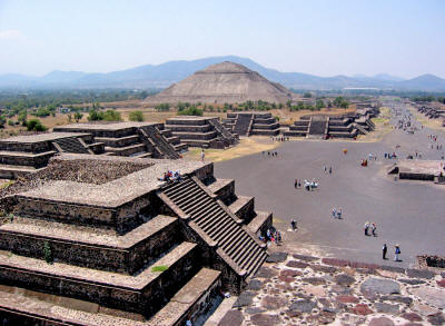
The great metropolis of Teotihuacan in the Valley of Mexico
appears
to have decisively intervened in Tikal politics.
The eighth king of Tikal was Chak Tok Ich'aak (Great Jaguar Paw).[32]
Chak Tok Ich'aak built a palace that was preserved and
developed by later rulers until it became the core of the Central
Acropolis.[38]
Little is known about Chak Tok Ich'aak
except that he was killed on 14 January 378 AD. On the same day,
Siyah K’ak’ (Fire Is Born) arrived from the west, having passed
through El Peru, a site to the west of Tikal, on 8 January.[32]
On Stele 31 he is named as "Lord of the West".[39]
Siyah K’ak’ was probably a foreign
general serving a figure represented by a non-Maya hieroglyph of a
spearthrower combined with an owl, a glyph that is well known from
the great metropolis of Teotihuacan in the distant Valley of Mexico.
Spearthrower Owl may even have been the ruler of Teotihuacan.
These recorded events strongly suggest
that Siyah K’ak’ led a Teotihuacan invasion that defeated the native
Tikal king, who was captured and immediately executed.[40]
Siyah K'ak' appears to have been aided by a powerful political
faction at Tikal itself;[41] roughly at the time of the
conquest, a group of Teotihuacan natives were apparently residing
near the Lost World complex.[42]
He also exerted control over other
cities in the area, including Uaxactun, where he became king, but
did not take the throne of Tikal for himself.[26][43] Within a year,
the son of Spearthrower Owl by the name of Yax Nuun Ayiin I (First
Crocodile) had been installed as the tenth king of Tikal while he
was still a boy, being enthroned on 13 September 379.[43][44]
He reigned for 47 years as king of
Tikal, and remained a vassal of Siyah K'ak' for as long as the
latter lived. It seems likely that Yax Nuun Ayiin I took a wife from
the pre-existing, defeated, Tikal dynasty and thus legitimized the
right to rule of his son, Siyaj Chan K'awiil II.[43]
Río Azul, a small site 100 kilometers (62 mi) northeast of Tikal,
was conquered by the latter during the reign of Yax Nuun Ayiin I.
The site became an outpost of Tikal, shielding it from hostile
cities further north, and also became a trade link to the Caribbean.[45]
Although the new rulers of Tikal were foreign, their descendents
were rapidly Mayanised.
Tikal became the key ally and trading
partner of Teotihuacan in the Maya lowlands. After being conquered
by
Teotihuacan, Tikal rapidly dominated the northern and eastern Peten. Uaxactun, together with smaller towns in the region, were
absorbed into Tikal's kingdom. Other sites, such as Bejucal and
Motul de San José near Lake Petén Itzá became vassals of their more
powerful neighbor to the north.
By the middle of the 5th century Tikal
had a core territory of at least 25 kilometers (16 mi) in every
direction.[42]
Around the 5th century an impressive system of fortifications
consisting of ditches and earthworks was built along the northern
periphery of Tikal's hinterland, joining up with the natural
defenses provided by large areas of swampland lying to the east and
west of the city. Additional fortifications were probably also built
to the south.
These defenses protected Tikal's core
population and agricultural resources, encircling an area of
approximately 120 square kilometers (46 sq mi).[26]
Tikal and Copán
In the 5th century the power
of the city reached as far south as Copán, whose founder K'inich Yax
K'uk' Mo' was clearly connected with Tikal.[38]
Copán
itself was not in an ethnically Maya region and the founding of the
Copán dynasty probably involved the direct intervention of Tikal.[46]
K'inich Yax K'uk' Mo' arrived in Copán in December 426 and bone
analysis of his remains shows that he passed his childhood and youth
at Tikal.[47]
An individual known as Ajaw K'uk' Mo'
(lord K'uk' Mo') is referred to in an early text at Tikal and may
well be the same person.[48] His tomb had Teotihuacan
characteristics and he was depicted in later portraits dressed in
the warrior garb of Teotihuacan. Hieroglyphic texts refer to him as
"Lord of the West", much like Siyah K’ak’.[47]
At the same time, in late 426, Copán
founded the nearby site of Quiriguá, possibly sponsored by Tikal
itself.[46] The founding of these two centers may have
been part of an effort to impose Tikal's authority upon the
southeastern portion of the Maya region.[49] The
interaction between these sites and Tikal was intense over the next
three centuries.[50]
A long-running rivalry between Tikal and Calakmul began in the 6th
century, with each of the two cities forming its own network of
mutually hostile alliances arrayed against each other in what has
been likened to a long-running war between two Maya superpowers. The
kings of these two capitals adopted the title kaloomte', a term that
has not been precisely translated but that implies something akin to
"high king".[51]
The early 6th century saw another queen ruling the city, known only
as the "Lady of Tikal", who was very likely a daughter of Chak Tok
Ich'aak II. She seems never to have ruled in her own right, rather
being partnered with male co-rulers.
The first of these was Kaloomte' B'alam,
who seems to have had a long career as a general at Tikal before
becoming co-ruler and 19th in the dynastic sequence. The Lady of
Tikal herself seems not have been counted in the dynastic numbering.
It appears she was later paired with
lord "Bird Claw", who is presumed to be the otherwise unknown 20th
ruler.[52]
Late Classic
Tikal hiatus
The main plaza, 2009
In the mid 6th century, Caracol seems to have allied with Calakmul
and defeated Tikal, closing the Early Classic.[53]
The
"Tikal hiatus" refers to a period between the late 6th to late 7th
century where there was a lapse in the writing of inscriptions and
large-scale construction at Tikal. In the latter half of the 6th
century AD a serious crisis befell the city, with no new stele
being erected and with widespread deliberate mutilation of public
sculpture.[54]
This hiatus in activity at Tikal was
long unexplained until later epigraphic decipherments identified
that the period was prompted by Tikal's comprehensive defeat at the
hands of Calakmul and the Caracol polity in AD 562, a defeat that
seems to have resulted in the capture and sacrifice of the king of
Tikal.[26] The badly eroded Altar 21 at Caracol described
how Tikal suffered this disastrous defeat in a major war in 562.
It
seems that Caracol was an ally of Calakmul in the wider conflict
between that city and Tikal, with the defeat of Tikal having a
lasting impact upon the city.[38]
Tikal was not sacked but its power and
influence were broken.[55] After its great victory,
Caracol grew rapidly and some of Tikal's population may have been
forcibly relocated there. During the hiatus period, at least one
ruler of Tikal took refuge with Janaab' Pakal of Palenque
(grandfather of
K'inich Janaab' Pakal), another
of Calakmul's victims.[56]
Calakmul itself thrived during
Tikal's long hiatus period.[57]
The beginning of the Tikal hiatus has served as a marker by which
archaeologists commonly sub-divide the Classic period of
Mesoamerican chronology into the
Early and Late Classic.[58]
Tikal and Dos Pilas
In 629 Tikal founded Dos Pilas, some 110 kilometers (68 mi) to the
southwest, as a military outpost in order to control trade along the
course of the Pasión River.[59]
B'alaj Chan K'awiil was installed on the
throne of the new outpost at the age of four, in 635, and for many
years served as a loyal vassal fighting for his brother, the king of
Tikal.[60] Roughly twenty years later Dos Pilas was
attacked by Calakmul and was soundly defeated. B'alaj Chan K'awiil
was captured by the king of Calakmul but, instead of being
sacrificed, he was re-instated on his throne as a vassal of his
former enemy,[61] and attacked Tikal in 657, forcing Nuun
Ujol Chaak, the then king of Tikal, to temporarily abandon the city.
The first two rulers of Dos Pilas
continued to use the Mutal emblem glyph of Tikal, and they probably
felt that they had a legitimate claim to the throne of Tikal itself.
For some reason, B'alaj Chan K'awiil was not installed as the new
ruler of Tikal; instead he stayed at Dos Pilas. Tikal
counterattacked against Dos Pilas in 672, driving B'alaj Chan
K'awiil into an exile that lasted five years.[62]
Calakmul tried to encircle Tikal within
an area dominated by its allies, such as El Peru, Dos Pilas and
Caracol.[63]
In 682, Jasaw Chan K'awiil erected the first dated monument at Tikal
in 120 years and claimed the title of kaloomte', so ending the
hiatus. He initiated a program of new construction and turned the
tables on Calakmul when, in 695, he captured the enemy king and
threw the enemy state into a long decline from which it never
recovered. After this, Calakmul never again erected a monument
celebrating a military victory.[56]
This defeat of Calakmul restored Tikal’s
pre-eminence in the Central Maya region, but never again in the
southwest Petén, where Dos Pilas maintained its presence.
Tikal after Teotihuacán
A vessel with jade inlays from the tomb of Jasaw Chan K'awiil I
beneath Temple I and bearing an effigy, probably that of the king.[64]
By the 7th century, there was no active Teotihuacan presence at any
Maya site and the centre of Teotihuacan had been razed by 700.
Even
after this, formal war attire illustrated on monuments was
Teotihuacan style.[65] Jasaw Chan K'awiil I and his heir
Yik'in Chan K'awiil continued hostilities against Calakmul and its
allies and imposed firm regional control over the area around Tikal,
extending as far as the territory around Lake Petén Itzá. These two
rulers were responsible for much of the impressive architecture
visible today.[66]
In 738, Quiriguá, a vassal of Copán, Tikal's key ally in the south,
switched allegiance to Calakmul, defeated Copán and gained its own
independence.[46] It appears that this was a conscious
effort on the part of Calakmul to bring about the collapse of
Tikal's southern allies.[67] This upset the balance of
power in the southern Maya area and lead to a steady decline in the
fortunes of Copán.[68]
In the 8th century, the rulers of Tikal collected monuments from
across the city and erected them in front of the North Acropolis.[69]
By the late 8th century and early 9th century, activity at Tikal
slowed.
Impressive architecture was still built but few hieroglyphic
inscriptions refer to later rulers.[66]
Terminal Classic
By the 9th century, the
crisis of the Classic Maya collapse was sweeping across the region,
with populations plummeting and city after city falling into
silence.[70]
Increasingly endemic warfare in the Maya
region caused Tikal's supporting population to heavily concentrate
close to the city itself, accelerating the use of intensive
agriculture and corresponding environmental decline.[71]
Construction continued at the beginning of the century, with the
erection of Temple 3, the last of the city's major pyramids and the
erection of monuments to mark the 19th K'atun in 810.[72]
The beginning of the 10th Bak'tun in 830
passed uncelebrated, and marks the beginning of a 60 year hiatus,
probably resulting from the collapse of central control in the city.[73]
During this hiatus, satellite sites traditionally under Tikal's
control began to erect their own monuments featuring local rulers
and using the Mutal emblem glyph, with Tikal apparently lacking the
authority or the power to crush these bids for independence.[66]
In 849, Jewel K'awiil is mentioned on a
stela at Seibal as visiting that city as the Divine Lord of Tikal
but he is not recorded elsewhere and Tikal's once great power was
little more than a memory. The sites of Ixlu and Jimbal had by now
inherited the once exclusive Mutal emblem glyph.[73]
As Tikal and its hinterland reached peak population, the area
suffered deforestation, erosion and nutrient loss followed by a
rapid decline in population levels. Tikal and its immediate
surroundings seem to have lost the majority of its population during
the period from 830 to 950 and central authority seems to have
collapsed rapidly.[21]
There is not much evidence from Tikal
that the city was directly affected by the endemic warfare that
afflicted parts of the Maya region during the Terminal Classic,
although an influx of refugees from the Petexbatún region may have
exacerbated problems resulting from the already stretched
environmental resources.[74]
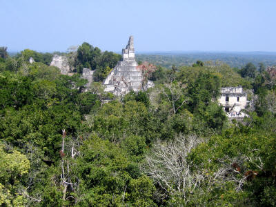
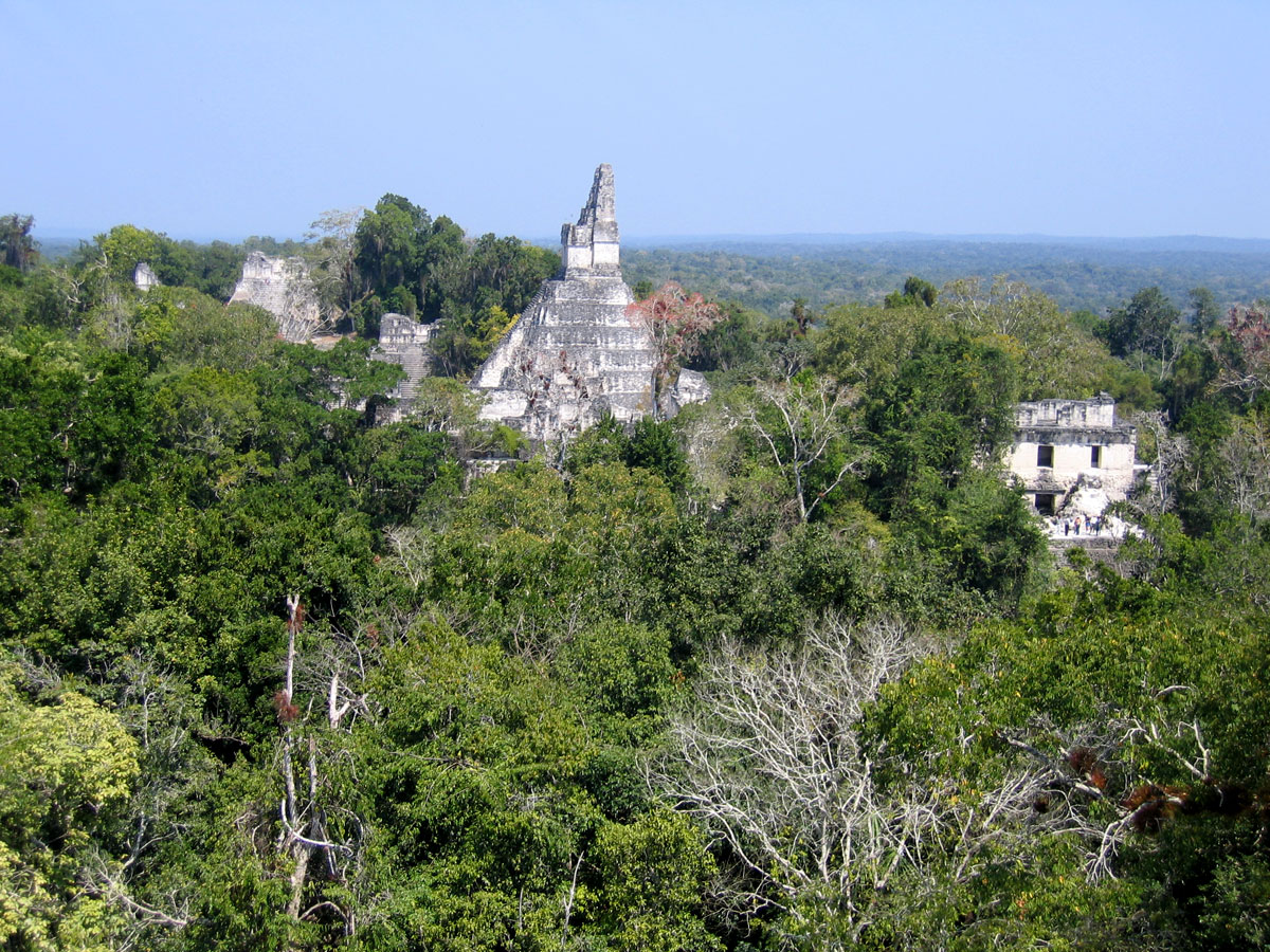
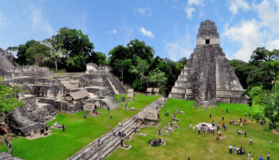
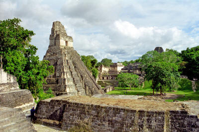
The site core seen
from the south, with Temple I at centre,
the North Acropolis
to the left and Central Acropolis to the right
In the latter half of the 9th century
there was an attempt to revive royal power at the much diminished
city of Tikal, as evidenced by a stela erected in the Great Plaza by
Jasaw Chan K'awiil II in 869.
This was the last monument erected at
Tikal before the city finally fell into silence. The former
satellites of Tikal, such as Jimbal and Uaxactun, did not last much
longer, erecting their final monuments in 889. By the end of the 9th
century the vast majority of Tikal's population had deserted the
city, its royal palaces were occupied by squatters and simple
thatched dwellings were being erected in the city's ceremonial
plazas.
The squatters blocked some doorways in
the rooms the reoccupied in the monumental structures of the site
and left rubbish that included a mixture of domestic refuse and
non-utilitarian items such as musical instruments. These inhabitants
reused the earlier monuments for their own ritual activities far
removed from those of the royal dynasty that had erected them.
Some monuments were vandalized and some
were moved to new locations.
Before its final abandonment all
respect for the old rulers had disappeared, with the tombs of the
North Acropolis being explored for jade and the easier to find tombs
being looted. After 950, Tikal was all but deserted, although a
remnant population may have survived in perishable huts interspersed
among the ruins. Even these final inhabitants abandoned the city in
the 10th or 11th centuries and the rainforest claimed the ruins for
the next thousand years.
Some of Tikal's population may have
migrated to the Peten Lakes region, which remained heavily populated
in spite of a plunge in population levels in the first half of the
9th century.[21][73][74]
The most likely cause of collapse at Tikal is overpopulation and
agrarian failure. The fall of Tikal was a blow to the heart of
Classic Maya civilization, the city having been at the forefront of
courtly life, art and architecture for over a thousand years, with
an ancient ruling dynasty.[75]
Modern history
In 1525, the Spanish
conquistador Hernán Cortés passed within a few kilometers of the
ruins of Tikal but did not mention them in his letters.[76]
As is often the case with huge ancient ruins, knowledge of the site
was never completely lost in the region. It seems that local people
never forgot about Tikal and they guided Guatemalan expeditions to
the ruins in the 1850s.[16]
Some second- or third-hand accounts of
Tikal appeared in print starting in the 17th century, continuing
through the writings of John Lloyd Stephens in the early 19th
century (Stephens and his illustrator Frederick Catherwood heard
rumors of a lost city, with white building tops towering above the
jungle, during their 1839-40 travels in the region).
Because of the site's remoteness from
modern towns, however, no explorers visited Tikal until Modesto Méndez and
Ambrosio Tut, respectively the commissioner and the
governor of Petén, visited it in 1848. Artist Eusebio Lara
accompanied them and their account was published in Germany in 1853.[77]
Several other expeditions came to further investigate, map, and
photograph Tikal in the 19th century (including Alfred P. Maudslay
in 1881-82) and the early 20th century.
Pioneering archaeologists started to
clear, map and record the ruins in the 1880s.[16]
In 1951, a small airstrip was built at the ruins,[15]
which previously could only be reached by several days’ travel
through the jungle on foot or mule. In 1956 the Tikal project began
to map the city on a scale not previously seen in the Maya area.[78]
From 1956 through 1970, major archaeological excavations were
carried out by the University of Pennsylvania Tikal Project.[79]
They mapped much of the site and
excavated and restored many of the structures.[16]
Excavations directed by Edwin Shook and later by
William Coe of the
University investigated the North Acropolis and the Central Plaza
from 1957 to 1969.[80] The Tikal Project recorded over
200 monuments at the site.[16] In 1979, the Guatemalan
government began a further archeological project at Tikal, which
continued through to 1984.[79]
Filmmaker George Lucas used Tikal as a setting in his first Star
Wars movie, Episode IV: A New Hope, released in 1977.[81][82]
Temple I at Tikal was featured on the reverse of the 50 centavo
banknote.[83]
Tikal is now a major tourist attraction surrounded by its own
national park.[16]
A site museum has been built at Tikal;
it was completed in 1964.[84]
The site
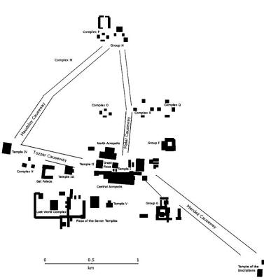
Map of the site core
Tikal has been partially restored by the
University of Pennsylvania and the government of Guatemala.[44] It
was one of the largest of the Classic period Maya cities and was one
of the largest cities in the Americas.[85]
The architecture of the ancient city is
built from limestone and includes the remains of temples that tower
over 70 meters (230 ft) high, large royal palaces, in addition to a
number of smaller pyramids, palaces, residences, administrative
buildings, platforms and inscribed stone monuments.[9][86]
There is even a building which seemed to have been a jail,
originally with wooden bars across the windows and doors. There are
also seven courts for playing the Mesoamerican ballgame, including a
set of 3 in the Seven Temples Plaza, a unique feature in
Mesoamerica.
The limestone used for construction was local and quarried on-site.
The depressions formed by the extraction of stone for building were
plastered to waterproof them and were used as reservoirs, together
with some waterproofed natural depressions.
The main plazas were
surfaced with stucco and laid at a gradient that channeled rainfall
into a system of canals that fed the reservoirs.[87]
The residential area of Tikal covers an estimated 60 square
kilometers (23 sq mi), much of which has not yet been cleared,
mapped, or excavated. A huge set of earthworks has been discovered
ringing Tikal with a 6-metre (20 ft) wide trench behind a rampart.
The 16 square kilometers (6.2 sq mi) area around the site core has
been intensively mapped;[66] it may have enclosed an area
of some 125 square kilometers (48 sq mi) (see below).
Population estimates place the
demographic size of the site between 10,000 and 90,000, and possibly
425,000 in the surrounding area.
Recently, a project exploring the
defensive earthworks has shown that the scale of the earthworks is
highly variable and that in many places it is inconsequential as a
defensive feature. In addition, some parts of the earthwork were
integrated into a canal system.
The earthwork of Tikal varies
significantly in coverage from what was originally proposed and it
is much more complex and multifaceted than originally thought.[88]
Causeways
By the Late Classic, a network of sacbeob (causeways) linked various
parts of the city, running for several kilometers through its urban
core.
These linked the Great Plaza with Temple
4 (located about 750 meters (2,500 ft) to the west) and the Temple
of the Inscriptions (about 1 kilometer (0.62 mi) to the southeast).[89]
These broad causeways were built of packed and plastered
limestone and have been named after early explorers and
archaeologists; the Maler, Maudslay, Tozzer and Méndez causeways.
They assisted the passage everyday
traffic during the rain season and also served as dams.[14]
-
The Maler Causeway runs north
from behind Temple I to Group H. A large bas-relief is
carved onto limestone bedrock upon the course of the
causeway just south of Group H. It depicts two bound
captives and dates to the Late Classic.[90]
-
The Maudsley Causeway runs 0.8
kilometers (0.50 mi) northeast from Temple IV to Group H.[90]
-
The Mendez Causeway runs
southeast from the East Plaza to Temple VI, a distance of
about 1.3 kilometers (0.81 mi).[77][91]
-
The Tozzer Causeway runs west
from the Great Plaza to Temple IV.[92]
Architectural groups
The North Acropolis
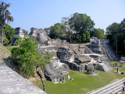
The Great Plaza lies at the
core of the site; it is flanked on the east and west sides by two
great temple-pyramids. On the north side it is bordered by the North
Acropolis and on the south by the Central Acropolis.[85]
The Central Acropolis is a palace complex just south of the Great
Plaza.[85]
The North Acropolis, together with the Great Plaza immediately to
the south, is one of the most studied architectural groups in the
Maya area; the Tikal Project excavated a massive trench across the
complex, thoroughly investigating its construction history. It is a
complex group with construction beginning in the Preclassic Period,
around 350 BC.
It developed into a funerary complex for
the ruling dynasty of the Classic Period, with each additional royal
burial adding new temples on top of the older structures. After AD
400 a row of tall pyramids was added to the earlier Northern
Platform, which measured 100 by 80 meters (330 by 260 ft), gradually
hiding it from view.
Eight temple pyramids were built in the
6th century AD, each of them had an elaborate roof-comb and a
stairway flanked by masks of the gods. By the 9th century AD, 43
stele and 30 altars had been erected in the North Acropolis; 18 of
these monuments were carved with hieroglyphic texts and royal
portraits. The North Acropolis continued to receive burials into the
Postclassic Period.[80][87]
The South Acropolis is found next to Temple V.
It was built upon a
large basal platform that covers an area of more than 20,000 square
meters (220,000 sq ft).[14]
Temples I, II, III and V as seen from Temple IV
The Plaza of the Seven Temples is to the west of the South
Acropolis. It is bordered on the east side by a row of nearly
identical temples, by palaces on the south and west sides and by an
unusual triple ball-court on the north side.[14][93]
Group G lies just south of the Mendez Causeway. The complex dates to
the Late Classic and consists of palace-type structures and is one
of the largest groups of its type at Tikal. It has two stories but
most of the rooms are on the lower floor, a total of 29 vaulted
chambers. The remains of two further chambers belong to the upper
storey. One of the entrances to the group was framed by a gigantic
mask.[77]
Group H is centered on a large plaza to the north of the Great
Plaza. It is bordered by temples dating to the Late Classic.[90]
There are nine Twin-Pyramid Complexes at Tikal, one of which was
completely dismantled in ancient times and some others were partly
destroyed. They vary in size but consist of two pyramids facing each
other on an east-west axis.[90] These pyramids are
flat-topped and have stairways on all four sides.
A row of plain stele is placed
immediately to the west of the eastern pyramid and to the north of
the pyramids, and lying roughly equidistant from them, there is
usually a sculpted stela and altar pair.
On the south side of these
complexes there is a long vaulted building containing a single room
with nine doorways. The entire complex was built at once and these
complexes were built at 20 year (or k'atun) intervals during the
Late Classic.[77]
The first Twin Pyramid Complex was built
in the early 6th century in the East Plaza.
It was once thought that
these complexes were unique to Tikal but rare examples have now been
found at other sites, such as Yaxha and Ixlu, and they may reflect
the extent of Tikal's political dominance in the Late Classic.[94]
Group Q is a twin-pyramid complex, and is one of the largest at
Tikal. It was built by Yax Nuun Ayiin II in 771 in order to mark the
end of the 17th K'atun.[94] Most of it has been restored
and its monuments have been re-erected.[77]
Group R is another twin-pyramid complex, dated to 790. It is close
to the Maler Causeway.[77]
Structures
Temple II on the main
plaza
There are thousands of ancient
structures at Tikal and only a fraction of these have been
excavated, after decades of archaeological work.
The most prominent surviving buildings
include six very large Mesoamerican step pyramids, labeled Temples
I - VI, each of which support a temple structure on their summits.
Some of these pyramids are over 60 meters high (200 feet). They were
numbered sequentially during the early survey of the site. It is
estimated that each of these major temples could have been built in
as little as two years.[95]
The majority of pyramids currently visible at Tikal were built
during Tikal’s resurgence following the Tikal Hiatus (i.e., from the
late 7th to the early 9th century).
It should be noted, however,
that the majority of these structures contain sub-structures that
were initially built prior to the hiatus.
-
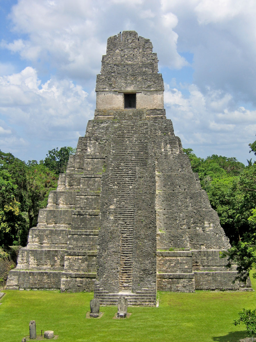
Temple I (also known as the Temple of Ah Cacao or Temple of the
Great Jaguar) is a funerary pyramid dedicated to Jasaw Chan K'awil,
who was entombed in the structure in AD 734,[80][85] the
pyramid was completed around 740-750.[96] The temple
rises 47 metres (150 ft) high.[1]
The massive roof-comb
that topped the temple was originally decorated with a giant
sculpture of the enthroned king, although little of this decoration
survives.[97]
The tomb of the king was discovered by
Aubrey Trik of the University of Pennsylvania in 1962.[18]
Among items recovered from the Late Classic tomb were a large
collection of inscribed human and animal bone tubes and strips with
sophisticated scenes depicting deities and people, finely carved and
rubbed with vermilion, as well as jade and shell ornaments and
ceramic vessels filled with offerings of food and drink.[18][98]
The shrine at the summit of the pyramid has three chambers,
each behind the next, with the doorways spanned by wooden lintels
fashioned from multiple beams.
The outermost lintel is plain but the
two inner lintels were carved, some of the beams were removed in the
19th century and their location is unknown, while others were taken
to museums in Europe.[95]
-
Temple II (also known as the Temple of the Mask) in was built around
AD 700 and stands 38 meters (120 ft) high. Like other major temples
at Tikal, the summit shrine had three consecutive chambers with the
doorways spanned by wooden lintels, only the middle of which was
carved.
The temple was dedicated to the wife of Hasaw Chan K'awil,
although no tomb was found. The queen's portrait was carved into the
lintel spanning the doorway of the summit shrine.
One of the beams
from this lintel is now in the American Museum of Natural History in
New York.[69][99]
-
Temple III (also known as the Temple of the Jaguar Priest) was the
last of the great pyramids to be built at Tikal. It stood 55 meters
(180 ft) tall and contained an elaborately sculpted but damaged roof
lintel, possibly showing Dark Sun engaged in a ritual dance around
AD 810.[72]
The temple shrine possesses two chambers.[100]
The elaborately carved wooden Lintel 3 from Temple IV.
It celebrates
a military victory by Yik'in Chan K'awiil in 743.[101]
-
Temple IV is the tallest temple-pyramid at Tikal, measuring 70
meters (230 ft) from the plaza floor level to the top of its roof
comb.[85]
Temple IV marks the reign of Yik’in Chan Kawil
(Ruler B, the son of Ruler A or Jasaw Chan K'awiil I) and two carved
wooden lintels over the doorway that leads into the temple on the
pyramid’s summit record a long count date (9.15.10.0.0) that
corresponds to C.E. 741 (Sharer 1994:169).
Temple IV is the largest pyramid built
anywhere in the Maya region in the 8th century,[102] and
as it currently stands is the tallest pre-Columbian structure in the
Americas although the Pyramid of the Sun at Teotihuacan may
originally have been taller, as may have been one of the structures
at El Mirador.[103]
-
Temple V stands almost 190 feet (58 m) tall and is still covered
with vegetation.[99]
-
Temple VI is also known as the Temple of the Inscriptions and was
dedicated in AD 766. It is notable for its 12-metre (39 ft) high
roof-comb. Panels of hieroglyphs cover the back and sides of the
roof-comb. The temple faces onto a plaza to the west and its front
is unrestored.[77]
-
Temple 33 is a funerary pyramid erected over the tomb of Siyaj Chan
K'awiil I (known as Burial 48) in the North Acropolis. It started
life in the Early Classic as a wide basal platform decorated with
large stucco masks that flanked the stairway.
Later in the Early
Classic a new superstructure was added, with its own masks and
decorated panels.
During the Hiatus a third stage was
built over the earlier constructions, the stairway was demolished
and another royal burial, of an unidentified ruler, was set into the
structure (Burial 23).
While the new pyramid was being built another
high ranking tomb (Burial 24) was inserted into the rubble core of
the building. The pyramid was then completed, standing 33 meters
(110 ft) tall.[104]
-
Structure 34 is a pyramid in the North Acropolis that was built by Siyaj Chan K'awiil II over the tomb of his father, Yax Nuun Ayiin I.
The pyramid was topped by a three chambered shrine, the rooms
situated one behind the other.[102]
Detail of Teotihuacan-related imagery decorating the sloping talud
sections
of the talud-tablero sides of Structure 5D-43.[105]
-
Structure 5D-43 is an unusual radial temple in the East Plaza, built
over a pre-exiting twin pyramid complex. It is built into the end of
the East Plaza Ballcourt and possessed four entry doorways and three
stairways, the fourth (south) side was too close to the Central
Acropolis for a stairway on that side.[106]
The building has a talud-tablero platform profile, modified from the original style
found at Teotihuacan.
In fact, it has been suggested that the
style of the building has closer affinities with El Tajin and
Xochicalco than with Teotihuacan itself. The vertical tablero panels
are set between sloping talud panels and are decorated with paired
disc symbols. Large flower symbols are set into the sloping talud
panels, related to the Venus and star symbols used at Teotihuacan.
The roof of the structure was decorated
with friezes although only fragments now remain, showing a monstrous
face, perhaps that of a jaguar, with another head emerging from the
mouth.[105] The second head possesses a bifurcated tongue
but is probably not that of a snake.[107]
The temple, and its associated ball-court,
probably date to the reign of Nuun Ujol Chaak or that of his son
Jasaw Chan K'awiil I, in the later part of the 7th century.[108]
-
Structure 5C-49 possesses a clear Teotihuacan-linked architectural
style; it has balustrades, an architectural feature that is very
rare in the Maya region, and a talud-tablero facade; it dates to the
4th century AD.[109] It is located near to the Lost World pyramid.[110]
-
Structure 5C-53 is a small Teotihuacan-style platform that dates to
about AD 600. It had stairways on all four sides and did not possess
a superstructure.[100]
A large stucco mask
adorning the substructure of Temple 33
-
The Lost World Pyramid (Structure 5C-54)
lies in the southwest portion of Tikal’s central core, south of
Temple III and west of Temple V.[89][91][111]
It was decorated with stucco masks of
the sun god and dates to the Late Preclassic;[14] this
pyramid is part of an enclosed complex of structures that remained
intact and un-impacted by later building activity at Tikal.
By the end of the Late Preclassic this
pyramid was one of the largest structures in the Maya region.[89]
It attained its final form during the reign of Chak Tok Ich'aak in
the 4th century AD, in the Early Classic, standing more than 30
meters (98 ft) high with stairways on all four sides and a flat top
that possibly supported a superstructure built from perishable
materials.[109][112]
Although the plaza later suffered
significant alteration, the organization of a group of temples on
the east side of this complex adheres to the layout that defines the
so-called E-Groups, identified as solar observatories.[113]
-
Structure 5D-96 is the central temple on the east side of the Plaza
of the Seven Temples. It has been restored and its rear outer wall
is decorated with skull-and-crossbones motifs.[114]
-
Group 6C-16 is an elite residential complex that has been thoroughly
excavated. It lies a few hundred meters south of the Lost World
Complex and the excavations have revealed elaborate stucco masks,
ballplayer murals, relief sculptures and buildings with Teotihuacan
characteristics.[109]
-
The Great Plaza Ballcourt is a small ball-court that lies between
Temple I and the Central Acropolis.[99]
-
The Bat Palace is also known as the Palace of Windows and lies to
the west of Temple III.[115] It has two stories, with a
double range of chambers on the lower storey and a single range in
the upper storey, which has been restored. The palace has ancient
graffiti and possesses low windows.[100]
-
Complex N lies to the west of the Bat Palace and Temple III. The
complex dates to AD 711.[116]
Altars
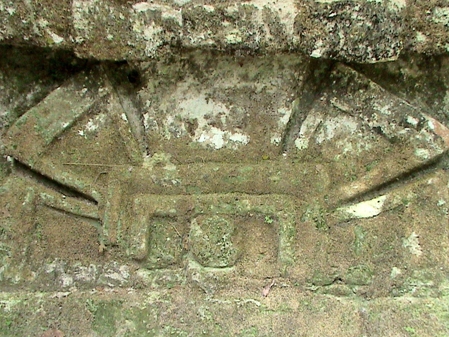
-
Altar 5 is carved with two nobles, one of whom is probably Jasaw
Chan K'awiil I. They are performing a ritual using the bones of an
important woman.[117] Altar 5 was found in Complex N,
which lies to the west of Temple III.[118]
-
Altar 8 is sculpted with a bound captive.[119] It was
found within Complex P in Group H and is now in the Museo Nacional
de Arqueología y Etnología in Guatemala City.[90]
-
Altar 9 is associated with Stela 21 and bears the sculpture of a
bound captive. It is located in front of Temple VI.[77]
-
Altar 10 is carved with a captive tied to a scaffold.[119]
It is in
the northern enclosure of Group Q, a twin-pyramid complex and has
suffered from erosion.[77]
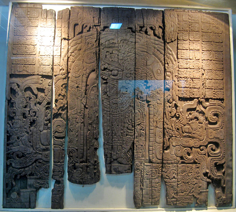
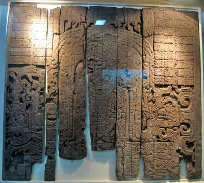
Lintels
At Tikal, beams of sapodilla wood were placed as lintels spanning
the inner doorways of temples. These are the most elaborately carved
wooden lintels to have survived anywhere in the Maya region.[120]
Lintel 3 from Temple IV was taken to Basel in Switzerland in the
19th century. It was in almost perfect condition and depicts Yik'in
Chan K'awiil seated on a palanquin.[121]
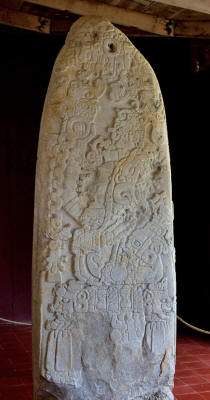
Stelae
Stelae are carved stone shafts, often sculpted with figures and
hieroglyphs.
A selection of the most notable stele at Tikal
follows:
-
Stela 1 dates to the 5th century and depicts the king Siyaj Chan
K'awiil II in a standing position.[122]
-
Stela 4 is dated to AD 396, during the reign of Yax Nuun Ayiin after
the conquest of Tikal by Teotihuacan.[123] The stela
displays a mix of Maya and Teotihuacan qualities, and deities from
both cultures. It has a portrait of the king with the Underworld
Jaguar God under one arm and the Mexican Tlaloc under the other. His
helmet is a simplified version of the Teotihuacan War Serpent.
Unusually for Maya sculpture, but typically for Teotihuacan, Yax
Nuun Ayiin is depicted with a frontal face, rather than in profile.[124]
-
Stela 5 was dedicated in 744 by Yik'in Chan K'awiil.[126]
-
Stela 6 is a badly damaged monument dating to 514 and bears the name
of the "Lady of Tikal" who celebrated the end of the 4th K'atun in
that year.[127]
-
Stela 10 is twinned with Stela 12 but is badly damaged. It described
the accession of Kaloomte' B'alam in the early 6th century and
earlier events in his career, including the capture of a prisoner
depicted on the monument.[128]
-
Stela 11 was the last monument ever erected at Tikal; it was
dedicated in 869 by Jasaw Chan K'awiil II.[73]
-
Stela 12 is linked to the queen known as the "Lady of Tikal" and
king Kaloomte' B'alam. The queen is described as performing the
year-ending rituals but the monument was dedicated in honour of the
king.[52]
-
Stela 16 was dedicated in 711, during the reign of Jasaw Chan
K'awiil I. The sculpture, including a portrait of the king and a
hieroglyphic text, are limited to the front face of the monument.[126]
It was found in Complex N, west of Temple III.[118]
-
Stela 19 was dedicated in 790 by Yax Nuun Ayiin II.[126]
-
Stela 20 was found in Complex P, in Group H, and was moved to the
Museo Nacional de Arqueología y Etnología in Guatemala City.[90]
-
Stela 21 was dedicated in 736 by Yik'in Chan K'awiil.[126]
Only the bottom of the stela is intact, the rest having been
mutilated in ancient times. The surviving sculpture is of fine
quality, consisting of the feet of a figure and of accompanying
hieroglyphic text. The stela is associated with Altar 9 and is
located in front of Temple VI.[77]
-
Stela 22 was dedicated in 771 by Yax Nuun Ayiin II in the northern
enclosure of Group Q, a twin-pyramid complex.[126] The
face of the figure on the stela has been mutilated.[77]
-
Stela 23 was broken in antiquity and was re-erected in a residential
complex. The defaced portrait on the monument is that of the
so-called "Lady of Tikal", a daughter of Chak Tok Ich'aak II who
became queen at the age of six but never ruled in her own right,
being paired with male co-rulers. It dates to the early 6th century.[127]
-
Stela 24 was erected at the foot of Temple 3 in 810, accompanied by
Altar 7. Both were broken into fragments in ancient times, although
the name of Dark Sun survives on three fragments.[72]
-
Stela 29 bears a Long Count date equivalent to AD 292, the earliest
surviving Long Count date from the Maya lowlands.[37] The
stela is also the earliest monument to bear the Tikal emblem glyph.
It bears a sculpture of the king facing to the right, holding the
head of an underworld jaguar god, one of the patron deities of the
city. The stela was deliberately smashed during the 6th century or
some time later, the upper portion was dragged away and dumped in a
rubbish tip close to Temple III, to be uncovered by archaeologists
in 1959.[129][130]
-
Stela 30 is the first surviving monument to be erected after the
Hiatus. Its style and iconography is similar to that of Caracol, one
of the more important of Tikal's enemies.[126]
-
Stela 31 is the accession monument of Siyah Chan K'awil II, also
bearing two portraits of his father, Yax Nuun Ayiin, as a youth
dressed as a Teotihuacan warrior. He carries a spear-thrower in one
hand and bears a shield decorated with the face of Tlaloc, the
Teotihuacan war god.[131]
In ancient times the sculpture
was broken and the upper portion was moved to the summit of Temple
33 and ritually buried.[132]
Stela 31, with the sculpted image of Siyah Chan K'awil II.
[125]
Stela 31 has been described as the
greatest Early Classic sculpture
to survive at Tikal. A long
hieroglyphic text is carved onto the back of the monument, the
longest to survive from the Early Classic,[125] which
describes the arrival of Siyah K'ak' at El Peru and Tikal in January
378.[39]
It was also the first stela as Tikal to be
carved on all four faces.[133]
-
Stela 32 is a fragmented monument with a foreign Teotihuacan-style
sculpture apparently depicting the lord of that city with the
attributes of the central Mexican storm god Tlaloc, including his
goggle eyes and tasseled headdress.[134]
-
Stela 39 is a broken monument that was erected in the Lost World
complex. The upper portion of the stela is missing but the lower
portion shows the lower body and legs of Chak Tok Ich'aak, holding a
flint axe in his left hand. He is trampling the figure of a bound,
richly dressed captive. The monument is dated to AD 376. The text on
the back of the monument describes a bloodletting ritual to
celebrate a Katun-ending.[112] The stela also names Chak
Tok Ich'aak I's father as K'inich Muwaan Jol.[37]
-
Stela 40 bears a portrait of Kan Chitam and dates to AD 468.[135]
Burials
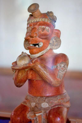
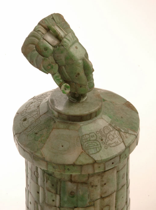
A ceramic censer representing an elderly deity,
found in Burial 10.[136]
-
Burial 1 is a tomb in the Lost World complex. A fine ceramic bowl
was recovered from the tomb, with the handle formed from
three-dimensional head and neck of a bird emerging from the
two-dimensional body painted on the lid.[137]
-
Burial 10 is the tomb of Yax Nuun Ayiin.[32] It is
located beneath Structure 34 in the North Acropolis. The tomb
contained a rich array of offerings, including ceramic vessels and
food, and nine youths were sacrificed to accompany the dead king.[102]
A dog was also entombed with the deceased king. Pots in the tomb
were stuccoed and painted and many demonstrated a blend of Maya and
Teotihuacan styles.[132]
Among the offerings was an
incense-burner in the shape of an elderly underworld god, sitting on
a stool made of human bones and holding a severed head in his hands.[138]
The tomb was sealed with a corbel vault, then the pyramid was built
on top.[102]
-
Burial 48 is generally accepted as the tomb of Siyah Chan K'awil. It
is located beneath Temple 33 in the North Acropolis.[104][139]
The chamber of the tomb was cut from the bedrock and contained the
remains of the king himself together with those of two adolescents
who had been sacrificed in order to accompany the deceased ruler.[139]
The walls of the tomb were covered with
white stucco painted with hieroglyphs that included the Long Count
date equivalent to 20 March 457, probably the date of either the
death or interment of the king.[54] The king's skeleton
was missing its skull, its femurs and one of its hands while the
skeletons of the sacrificial victims were intact.[98]
-
Burial 85 dates to the Late Preclassic and was enclosed by a
platform, with a primitive corbel vault. The tomb contained a single
male skeleton, which lacked a skull and its thighbones.[25][30]
The dynastic founder of Tikal, Yax Ehb'
Xook, has been linked to this tomb, which lies deep in the heart of
the North Acropolis.[25] The deceased had probably died
in battle with his body being mutilated by his enemies before being
recovered and interred by his followers. The bones were wrapped
carefully in textiles to form an upright bundle.[140]
The missing head was replaced by a small
greenstone mask with shell-inlaid teeth and eyes and bearing a
three-pointed royal headband.[25][141] This head wears an
emblem of rulership on its forehead and is a rare Preclassic lowland
Maya portrait of a king.[53] Among the contents of the
tomb were a stingray spine, a spondylus shell and twenty-six ceramic
vessels.[141]
-
Burial 116 is the tomb of Jasaw Chan K'awiil I. It is a large
vaulted chamber deep within the pyramid, below the level of the
Great Plaza.
The tomb contained rich offerings of
jadeite, ceramics, shell and works of art. The body of the king was
covered with large quantities of jade ornaments including an
enormous necklace with especially large beads, as depicted in
sculpted portraits of the king. One of the outstanding pieces
recovered from the tomb was an ornate jade mosaic vessel with the
lid bearing a sculpted portrait of the king himself.[142]
-
Burial 195 was flooded with mud in antiquity. This flood had covered
wooden objects that had completely rotted away by the time the tomb
was excavated, leaving hollows in the dried mud. Archaeologists
filled these hollows with stucco and thus excavated four effigies of
the god K'awiil, the wooden originals long gone.[143][144]
-
Burial 196 is a Late Classic royal tomb that contained a jade mosaic
vessel topped with the head of the Maize God.[13]
Notes
|
1. Martin & Grube
2000, p.47.
2. UNESCO World Heritage Centre.
3. Sharer & Traxler 2006, p.1. Hammond 2000, p.233.
4. Martin & Grube 2008, pp.29-32.
5. Adams 2000, p.34.
6. Martin & Grube 2000, p.30.
7. Drew 1999, p.136.
8. Schele & Mathews 1999, p.64.
9. Sharer & Traxler 2006, p.1.
10. Kelly 1996, pp.111-2.
11. Webster 2002, p.118.
12. Webster 2002, pp.188, 192.
13. Coe 1999, p.104.
14. Drew 1999, p.185.
15. Kelly 1996, p.140.
16. Webster 2002, p.261.
17. Webster 2002, p.239.
18. Coe 1999, p.124.
19. Torres.
20. Coe 1999, p.30.
21. Webster 2002, p.264.
22. Martin & Grube 2000, p.25.
23. Sharer & Traxler 2006, pp.310-2
24. Martin & Grube 2000 pp.26-52.
25. Drew 1999, p.187.
26. Webster 2002, p.262.
27. Coe 1999, p.55.
28. Coe 1999, p.73.
29. Coe 1999, pp.73, 80.
30. 1999, p.75.
31. Coe 1999, p.78.
32. Coe 1999, p.90.
33. Miller 1999, pp.88-9.
34. Webster 2002, p.191.
35. Sharer 1994, p.265.
36. Kelly 1996, p.129.
37. Martin & Grube 2000, p.27.
38. Webster 2002, p.192.
39. Drew 1999, p.199.
40. Coe 1999, pp.90-1.
41. Webster 2002, p.133.
42. Drew 1999, p.201.
43. Drew 1999, p.200.
44. Coe 1999, p.97.
45. Drew 1999, pp.201-2.
46. Wyllys Andrews & Fash 2005, p.407.
47. Fash & Agurcia Fasquelle 2005, p.26.
48. Looper 2003, p.37.
49. Looper 2003, p.38. |
50. Looper 1999, p.263.
51. Webster 2002, pp.168-9.
52. Martin & Grube 2000, pp.38-9.
53. Miller 1999, p.89.
54. Coe 1999, p.94.
55. Webster 2002, pp.192-3.
56. Webster 2002, p.193.
57. Webster 2002, p.194.
58. Miller and Taube 1993, p.20.
59. Salisbury et al 2002, p.1.
60. Salisbury et al 2002, pp.2-3.
61. Salisbury et al 2002, p.2.
62. Webster 2002, p.276.
63. Hammond 2000, p.220.
64. Webster 2002, pl.13.
65. Miller 1999, p.105.
66. Webster 2002, p.263.
67. Looper 2003, p.79.
68. Wyllys Andrews & Fash 2005, p.408.
69. Miller 1999, p.33.
70. Martin & Grube 2000, pp.52-3.
71. Webster 2002, p.340.
72. Martin & Grube 2000, p.52.
73. Martin & Grube 2000, p.53.
74. Webster 2002, p.273.
75. Webster 2002, p.274.
76. Webster 2002, pp.83-4.
77. Kelly 1996, p.139.
78. Adams 2000, p.19.
79. Adams 2000, p.30.
80. Martin & Grube 2000, p.43.
81. Webster 2002, p.29.
82. StarWars.com
83. Banco de Guatemala.
84. Coe 1967, 1988, p.10.
85. Coe 1999, p.123.
86. Drew 1999, p.183.
87. Drew 1999, p.186.
88. Martínez et al 2004, pp.639-640.
89. Hammond 2000, p.227.
90. Kelly 1996, p.138.
91. Martin & Grube 2000, p.24.
92. Sharer & Traxler 2006, p.302.
93. Sharer & Traxler 2006, p.304.
94. Martin & Grube 2000, p.51.
95. Kelly 1996, p.133.
96. Webster 2002, pl.15.
97. Miller 1999, p.27.
98. Miller 1999, p.78.
99. Kelly 1996, p.134.
|
100. Kelly 1996, p.136.
101. Miller 1999, p.13.
102. Miller 1999, p.32.
103. Kelly 1996, p.137.
104. Martin & Grube 2000, p.36.
105. Schele & Mathews 1999, p.72.
106. Schele & Mathews 1999, p.71.
107. Schele & Mathews 1999, pp.72-3.
108. Schele & Mathews 1999, pp.70-1.
109. Hammond 2000, p.228.
110. Miller 1999, p.30.
111. Kelly 1996, p.130.
112. Drew 1999, p.188.
113. Hammond 2000, pp.227-8.
114. Kelly 1996, p.135.
115. Kelly 1996, pp.130, 136.
116. Kelly 1996, pp. 136-7.
117. Webster 2002, pl.14.
118. Kelly 1996, p.137.
119. Miller 1999, p.130.
120. Miller 1999, pp.130-1.
121. Miller 1999, p.131.
122. Miller 1999, p.153.
123. Miller 1999, p.94.
124. Miller 1999, p.95.
125. Miller 1999, p.97.
126. Miller 1999, p.129.
127. Martin & Grube 2000, p.38.
128. Martin & Grube 2000, p.39.
129. Miller 1999, p.91.
130. Drew 1999, pp.187-8.
131. Coe 1999, pp.91-2.
132. Miller 1999, p.96.
133. Miller 1999, p.98.
134. Martin & Grube 2000, p.31.
135. Martin & Grube 2000, p.37.
136. Martin & Grube 2000, p.33.
137. Miller 1999, pp.193-4.
138. Drew 1999, p.197.
139. Coe 1999, p.91.
140. Coe 1999, pp.75-6.
141. Coe 1999, p.76.
142. Sharer & Traxler 2006, pp.397-399.
143. Martin & Grube 2000, p.41.
144. Miller 1999, p.216.
|
References
-
Adams, Richard E.W. (2000).
"Introduction to a Survey of the Native Prehistoric Cultures of
Mesoamerica". in Richard E.W. Adams and Murdo J. Macleod (eds.).
The Cambridge History of the Native Peoples of the Americas,
Vol. II: Mesoamerica, part 1. Cambridge, UK: Cambridge
University Press. pp. 1-44. ISBN 0-521-35165-0. OCLC 33359444.
-
Andrews, E. Wyllys; and William L.
Fash (2005). "Issues in Copán Archaeology". in E. Wyllys Andrews
and William L. Fash (eds.). Copán: The History of an Ancient
Maya Kingdom. Santa Fe and Oxford: School of American Research
Press and James Currey Ltd. pp. 395-425. ISBN 0-85255-981-X.
OCLC 56194789.
-
Banco de Guatemala. "Monedas". Banco
de Guatemala. http://www.banguat.gob.gt/inc/ver.asp?id=/monedasybilletes/ilustraciones-11-denominaciones.htm&e=40306.
Retrieved 2009-11-13. (Spanish)
-
Coe, Michael D. (1999). The Maya.
Ancient peoples and places series (6th edition, fully revised
and expanded ed.). London and New York: Thames & Hudson. ISBN
0-500-28066-5. OCLC 59432778.
-
Coe, William R. (1967, 1988). Tikal:
Guía de las Antiguas Ruinas Mayas. Guatemala: Piedra Santa. ISBN
84-8377-246-9. (Spanish)
-
Drew,David (1999). The Lost
Chronicles of the Mayan Kings. Los Angeles: University of
California Press.
-
Fash, William L.; and Ricardo
Agurcia Fasquelle (2005). "Contributions and Controversies in
the Archaeology and History of Copán". in E. Wyllys Andrews and
William L. Fash (eds.). Copán: The History of an Ancient Maya
Kingdom. Santa Fe and Oxford: School of American Research Press
and James Currey Ltd. pp. 3-32. ISBN 0-85255-981-X. OCLC
56194789.
-
Gill, Richardson B. (2000). The
Great Maya Droughts: Water, Life, and Death. Albuquerque:
University of New Mexico Press. ISBN 0-826-32194-1. OCLC
43567384.
-
Hammond, Norman (2000). "The Maya
Lowlands: Pioneer Farmers to Merchant Princes". in Richard E.W.
Adams and Murdo J. Macleod (eds.). The Cambridge History of the
Native Peoples of the Americas, Vol. II: Mesoamerica, part 1.
Cambridge, UK: Cambridge University Press. pp. 197-249. ISBN
0-521-35165-0. OCLC 33359444.
-
Harrison, Peter D. (2006). "Maya
Architecture at Tikal". in Nikolai Grube (ed.). Maya: Divine
Kings of the Rain Forest. Eva Eggebrecht and Matthias Seidel
(assistant eds.). Köln: Könemann. pp. 218-231. ISBN
3-8331-1957-8. OCLC 71165439.
-
Kelly, Joyce (1996). An
Archaeological Guide to Northern Central America: Belize,
Guatemala, Honduras, and El Salvador. Norman: University of
Oklahoma Press. ISBN 0-8061-2858-5. OCLC 34658843.
-
Kerr, Justin (n.d.). "A Precolumbian
Portfolio" (online database). FAMSI Research Materials.
Foundation for the Advancement of Mesoamerican Studies, Inc.
http://research.famsi.org/kerrportfolio.html. Retrieved
2007-06-13.
-
Looper, Matthew G. (1999). "New
Perspectives on the Late Classic Political History of Quirigua,
Guatemala". Ancient Mesoamerica (Cambridge and New York:
Cambridge University Press) 10 (2): 263-280. ISSN 0956-5361.
OCLC 86542758.
-
Looper, Matthew G. (2003). Lightning
Warrior: Maya Art and Kingship at Quirigua. Linda Schele series
in Maya and pre-Columbian studies. Austin: University of Texas
Press. ISBN 0-292-70556-5. OCLC 52208614.
-
Martin, Simon; and Nikolai Grube
(2000). Chronicle of the Maya Kings and Queens: Deciphering the
Dynasties of the Ancient Maya. London and New York: Thames &
Hudson. ISBN 0-500-05103-8. OCLC 47358325.
-
Martin, Simon; and Nikolai Grube
(2008). Chronicle of the Maya Kings and Queens: Deciphering the
Dynasties of the Ancient Maya (2nd edn (revised) ed.). London
and New York: Thames & Hudson. ISBN 978-0-500-28726-2. OCLC
191753193.
-
Martínez, Horacio; David Webster;
Jay Silverstein; Timothy Murtha; Kirk Straight and Irinna
Montepeque (2004). "Reconocimiento en la periferia de Tikal: Los
Terraplenes Norte, Oeste y Este, nuevas exploraciones y
perspectivas" (PDF online publication). XVII Simposio de
Investigaciones Arqueológicas en Guatemala, 2003 (edited by J.P.
Laporte, B. Arroyo, H. Escobedo and H. Mejía). Museo Nacional de
Arqueología y Etnología, Guatemala. pp. 635-641. http://www.asociaciontikal.com/pdf/56.03%20-%20Horacio%20-%20en%20PDF.pdf.
Retrieved 2009-06-24. (Spanish)
-
Miller, Mary Ellen (1999). Maya Art
and Architecture. London and New York: Thames & Hudson. ISBN
0-500-20327-X. OCLC 41659173.
-
Miller, Mary; and Karl Taube (1993).
The Gods and Symbols of Ancient Mexico and the Maya: An
Illustrated Dictionary of Mesoamerican Religion. London: Thames
& Hudson. ISBN 0-500-05068-6. OCLC 27667317.
-
Salisbury, David; Mimi Koumenalis,
and Barbara Moffett (19 September 2002). "Newly revealed
hieroglyphs tell story of superpower conflict in the Maya world"
(PDF online publication). Exploration: the online research
journal of Vanderbilt University (Nashville, TN: Vanderbilt
University Office of Science and Research Communications). OCLC
50324967. http://exploration.vanderbilt.edu/print/pdfs/news/news_dospilas_feature.pdf.
Retrieved 2009-09-22.
-
Schele, Linda; and Peter Mathews
(1999). The Code of Kings: The language of seven Maya temples
and tombs. New York: Simon & Schuster. ISBN 978-0-684-85209-6.
OCLC 41423034.
-
Sharer, Robert J.; with Loa P.
Traxler (2006). The Ancient Maya (6th, fully revised ed.).
Stanford, CA: Stanford University Press. ISBN 0-8047-4817-9.
OCLC 57577446.
-
StarWars.com. "Star Wars: Episode IV
A New Hope". Lucasfilm Ltd. http://www.starwars.com/movies/episode-iv/.
Retrieved 2009-11-13.
Torres, Estuardo. "Parque Nacional Tikal". Ministerio de Cultura
y Deportes. http://www.mcd.gob.gt/2009/04/03/parque-nacional-tikal/.
Retrieved 2009-11-14. (Spanish)
-
UNESCO World Heritage Centre. "Tikal
National Park". UNESCO World Heritage Centre. http://whc.unesco.org/en/list/64.
Retrieved 2009-11-13.
-
Webster, David L. (2002). The Fall
of the Ancient Maya: Solving the Mystery of the Maya Collapse.
London: Thames & Hudson. ISBN 0-500-05113-5. OCLC 48753878.
Back to Contents
Tikal
del Sitio Web
Wikipedia

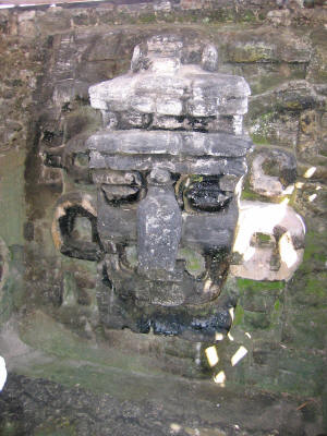
Templo II o Templo de las Máscaras
y también denominado Templo de la
Luna.
Tikal es la más grande de las antiguas ciudades de los mayas del
período clásico. Está situada en la región de Petén, en el
territorio actual de Guatemala.
Tikal fue uno de los principales centros culturales y poblacionales
de la civilización maya. La tumba del posible fundador de la
dinastía Yax Ehb' Xook data de ca. año 60, aunque muestra ocupación
desde ca. 600 a. C. según hallazgos en Mundo Perdido, la parte más
antigua de la ciudad.
Prosperó principalmente durante el período clásico maya,
aproximadamente de 200 a 850, después del cual no se construyeron
monumentos mayores, algunos palacios de la élite fueron quemados, y
la población gradualmente decayó hasta que el sitio fue abandonado a
finales del siglo X.
El último monumento fechado data de 899.
Toponimia
El nombre "Tikal" significa "Lugar de las Voces" o "Lugar de las
Lenguas" en maya, y fue acuñado por Sylvanus Morley.
Su verdadero
nombre de acuerdo a los textos jeroglíficos es Mutul o Yax Mutul de
Mut nudo, haciendo referencia al peinado del Ku'hul Ahaw o máximo
Gobernante.
La
Ciudad
Templo 1 o Templo del Gran Jaguar.
Los estudiosos estiman que en su máximo apogeo, tuvo una población
de 100.000 a 150.000 habitantes.
Entre los edificios más prominentes
que sobreviven están seis grandes templos piramidales y el palacio
real, además de algunas pirámides más pequeñas, palacios,
residencias y piedras talladas.
El área residencial de Tikal cubre un estimado de 60 km², de los
cuales sólo 16 km² han sido limpiados o excavados. En la actualidad
existen dudas acerca de la posible demografía que se sitúa en un
amplio abanico de 100.000 a 200.000 habitantes, superando los 49.000
habitantes estimados por Haviland en 1970.
En la Acrópolis Central,
que fue su centro administrativo, y comprende 45 estructuras se
encuentra un Palacio de cinco pisos de altura.
-
El templo principal (o también denominado templo I), que cierra la
plaza por el lado este, es el denominado Templo del Gran Jaguar, con
una altura total de 55 m. Se piensa que fue construido hacia el año
700, y es la tumba de Hasaw Cha'an Kawil, el que devolvió la
supremacía de Tikal sobre las otros centros mayas, al derrotar
sucesivamente a Waka', Caracol y Calakmul.
-
El templo II, denominado Templo de las Máscaras o "Pirámide de La
Luna", con una altura de 50 m, cierra la gran plaza por el lado
oeste y es la tumba de la esposa de Hasaw Cha'an Kawil. La Acrópolis
Norte a la derecha de estos Templos es un conjunto de Pirámides más
pequeñas y que fueron la Tumba de los Primeros Señores de Tikal.
-
El Templo III, o Templo del Gran Sacerdote, fue el último en ser
construido. 810 d.c. por Chi’taam , es el que tiene la crestería más
fina y mejor conservada del Mundo Maya.
-
El Templo IV o Templo de la Serpiente Bicéfala, es el más alto del
sitio con 64 m, fue construido por el hijo de Hasaw Cha'an Kawil,
Yaxk'in Cha'an Chac que tomo el poder el 12 de diciembre de 734,
esta era considerada la construcción más alta de la América
Precolombina, hasta el descubrimiento de la Pirámide de La Danta, en
El Mirador, que con sus 72 m de altura, es el edificio más alto de
la América Precolombina y el de mayor volumen de construcción en el
Mundo Antiguo, con sus 2,800,000 Metros cúbicos.
-
El Templo V ca. 780, es la única pirámide del sitio en la cual no
se ha descubierto una Tumba.
-
El Templo VI o De las Inscripciones, llamado así por el extenso
texto, en su parte trasera, el más largo de un templo Maya, fue
comisionado por Yaxk'in Ca'an Chac ca. 750.
Templo IV o Templo de la Serpiente Bicéfala,
el
mayor de Tikal, visto desde Mundo Perdido.
Como es frecuente el caso con grandes ruinas antiguas, el
conocimiento del sitio nunca se perdió completamente en la región.
Algunos apuntes de segunda o tercera mano aparecen impresos
comenzando en el siglo XVII, y continuando con los escritos de
John
Lloyd Stephens a principios del siglo XIX. Debido a lo remoto que se
encuentra de las ciudades modernas, sin embargo, ninguna expedición
científica visitó Tikal sino hasta 1848. Fue reportada en 1848, por
Modesto Méndez y Ambrosio Tut, corregidor y gobernador de Petén,
respectivamente.
Eusebio Lara acompañó esta primera expedición para elaborar las
primeras ilustraciones de los monumentos. Muchas otras expediciones
llegaron para seguir investigando, dibujando mapas, y fotografiando Tikal en los siglos XIX y XX.
En 1853, posterior a la publicación del diario de Méndez en la
Gaceta de Guatemala, se da a conocer a la comunidad científica el
descubrimiento, en una publicación de la Academia de Ciencias de
Berlín.
Dos
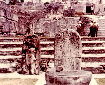
estelas en la Acrópolis Norte.
En 1951 se construyó una pequeña pista de aterrizaje cerca de las
ruinas, que anteriormente sólo podían ser alcanzadas luego de varios
días de viaje a través de la selva a pie o en mula.
De 1956 a 1970
se hicieron importantes excavaciones arqueológicas por parte de la
Universidad de Pensilvania. En 1979 el gobierno guatemalteco inició
un proyecto arqueológico en Tikal, que continúa hasta el día de hoy.
Las ruinas de Tikal, como parte del Parque Nacional Tikal, fueron el
primer sitio arqueológico en ser declarado Patrimonio de la
Humanidad en 1979, y así mismo, el primer Patrimonio de la Humanidad
mixto, (ecológico y arqueológico), del mundo. El sitio puede ser
visitado por el público, todos los días del año, una carretera
asfaltada de 76 km comunica a Tikal con Flores, la principal ciudad
del Petén.
Tikal fue usada como escenario de la base rebelde en la película
Star Wars y es el modelo de la ciudad Maya en la película de Mel
Gibson, Apocalypto.
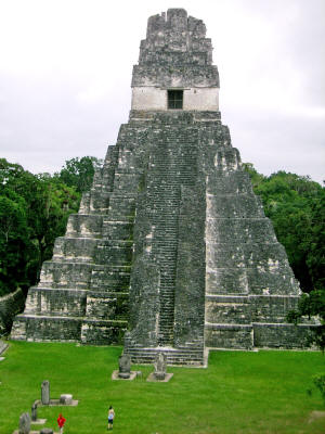
Vista de la pirámide Templo I o Templo del Gran Jaguar,
con sus
nueve terrazas escalonadas,
desde el templo II o Templo de las
Máscaras.
Urbanismo
A través de los enlaces especificados en la bibliografía se puede
observar un debate en el tiempo en torno al estudio poblacional de
Tikal entroncado en un debate superior:
Su estructura dista
mucho del modelo habitual de las ciudades de la Tierra Alta de
Mesoamérica (ej. Tenochtitlán) con distribución ortogonal,
rectilínea, ordenada y planificada.
Aún así, la demografía elevada,
las estructuras palaciales y los trabajos hidráulicos apoyan la
tesis de una Tikal urbana.
Reyes
|
Nombre (o
sobrenombre) |
[1]
[2]
Gobierno |
Dinastía
Sucesor No. |
|
Yax Ehb' Xook |
c.
90 |
1 |
Yax Moch Xok, Yax
Chakte'l Xok, First Scaffold Shark |
|
Foliated Jaguar |
c.
292 |
? |
- |
|
Animal Headdress |
? |
10? |
Kinich Ehb'? |
|
Siyaj Chan K'awiil I |
c.
307 |
11 |
- |
|
Lady Une' B'alam |
c.
317 |
12? |
- |
|
K'inich Muwaan Jol I |
? -359 |
13 |
Mahk'ina Cráneo de
Pájaro, Cráneo Emplumado |
|
Chak Tok Ich'aak I |
360-378 |
14 |
Garra de Jaguar,
Gran Garra, Gran Garra de Jaguar |
|
Yax Nuun Ayiin I |
379 -404? |
15 |
Hocico Enrollado,
Pico Enrollado |
|
Siyaj Chan K'awiil
II |
411-456 |
16 |
Stormy Sky, Manikin
Cleft Sky |
|
Kan Chitam |
458-c. 486 |
17 |
Jabalí Kan, K'an Ak |
|
Chak Tok Ich'aak II |
c.
486-508 |
18 |
Garra de Jaguar II,
Cráneo de Garra de Jaguar |
|
Señora de Tikal |
Kaloomte' B'alam |
c.
511-527+ |
19 |
Cabeza Enrollada |
|
Garra de Pájaro |
? |
20? |
Cráneo de Animal I |
|
Wak Chan K'awiil |
537?-562 |
21 |
Pájaro Doble |
|
Cráneo de Animal |
c.
593-628 |
22 |
- |
|
K'inich Muwaan Jol
II |
c.
628-650 |
23 or 24 |
- |
|
Nuun Ujol Chaak |
c.
650-679 |
25 |
Cráneo Protector,
Nun Bak Chak |
|
Jasaw Chan K'awiil I |
682-734 |
26 |
Ruler A, Ah Cacao |
|
Yik'in Chan K'awiil |
734-c. 766 |
27 |
Ruler B, Yaxkin Caan
Chac, Sun Sky Rain |
|
Ruler 28 |
c.
766-768 |
28 |
- |
|
Yax Nuun Ayiin II |
768-c. 794 |
29 |
- |
|
Nuun Ujol K'inich |
c.
800? |
30? |
- |
|
Sol Oscuro |
-810+ |
31? |
- |
|
Jewel K'awiil |
-849+ |
? |
- |
|
Jasaw Chan K'awiil
II |
-869+ |
? |
- |
|
Regresar al Contenido
|