|
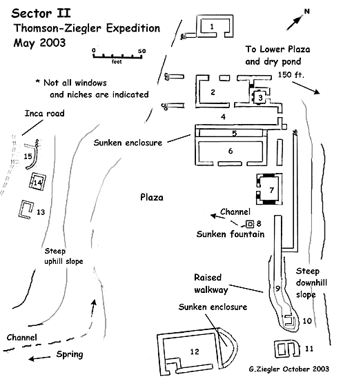
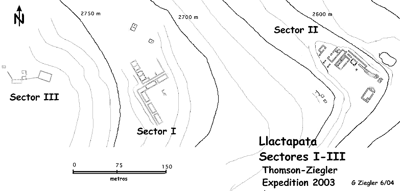
Sector II
Sector II plan
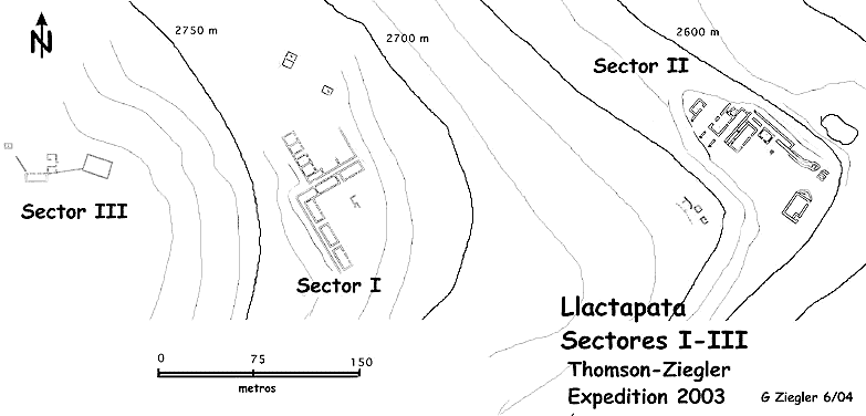
The relationship of Sectors I – III
This
sector was visited and reported for the first time in 1982 (Drew 1982, Thomson
2001).
The sector
consists of a tightly grouped assortment of carefully constructed large
buildings, walls and smaller structures arranged around a central plaza with
several outlying structures of lesser quality. The group sits upon a flat bench
with a steep, rising embankment behind and a steep downhill slope to the front.
Another levelled, plaza like, area is situated just below (NE) which may have
been a pond or water feature now dry and filled in. The only present water
source identified for the region, a spring, is located just above to the south
of the plaza. Remains of a stone lined channel
acequia originating at the spring
is indicated on the site plan. This leads into a nicely made, sunken, stone
lined enclosure (8) resembling one of the fountains or ritual baths at Machu
Picchu or Wińay Wayna.
The main
buildings (1-7) have shaped corner blocks of quartzite and coursed slabs, with
blocks for the walls. Remains of clay indicate that the structures were
plastered. Roots and trees have crumbled parts of most structures, but some
walls are standing close to the original height. Building 6 has a back wall
height of 14 feet. 1, 2 and 6 had gabled roofs; number 12 may have as well.
This is undetermined for the remainder. Buildings 1-7 had internal niches and
some windows. Minor details are lacking because of surveying demands created by
the unexpected size and extent of the findings.
By contrast,
structures 12-14 are of poorly constructed, mortared fieldstone without niches.
Structure 13 has a low walled open side and a long low window lined with adobe
blocks. Four rocker-shaped grinding
stones for corn were found inside, made of granite. Building 12 appears to have
been modified by an internal enclosure.
It is likely that local farmers or herders used these buildings in later
times. Building 12 could have served as a caretaker residence or entrance
control for the main group as suggested for structure 12, Sector I.
The central
section of the group has multiple passageways that open out to a long filled,
low walled platform/walkway that forms an overlook of Huayna-Machu Picchu and
the Veronica Range beyond. The long axis points to and views the Overlook
Temple (Sector V).
Building 2 has a
window that opens into a short corridor viewing Huayna Picchu. Structure 3 is a
small structure 10 feet by 10 feet with 4 internal niches. The one entranceway
faces 50 degrees toward Huayna Picchu. It size and location suggest that it was
a shrine.
Feature 4 is a
courtyard like area between building 2 and a long sunken enclosure
recinto (5) It is closed by a wall at the end
that faces Huayna Picchu. Here an entranceway with an alignment of 50 degrees
opens to the outside platform/walkway.
Structure 9 is a low wall slightly above the
plaza level that measures six feet high on the downhill side. The wall merges
into a raised earth platform, which takes a curious jog to terminate at
structure 10. The wall and mount may have been used as a ritual walkway to
reach a shrine. This feature is a small 10 feet x 10 feet U shaped structure
masma with
the open side facing inward to the plaza at 230 degrees.
Building 7 is an
interesting feature. It is an unusual structure 30 feet by 30 feet with
internal niches and a single entranceway facing into the plaza. The back or
Huayna Picchu side lacks windows and has five rectangular niches. The two sides
perpendicular to the entrance have matching long windows. The workmanship is in
the best Vilcabamba style, with shaped corner blocks and carefully fitted,
coursed, wall stones. The location gives immediate access to the bath/fountain
(8) and water system. The building remains an enigma deserving further study.
A steep
escarpment falls off to the northeast. Some 20 metres below is a sizable
pampa area with swampy depressions and a profusion
of water plants. This may have been a
pond or developed water feature associated with the group above. It was used by
both Bingham and this recent expedition as a base camp.
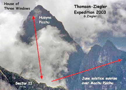
A most notable aspect of this Sector is that the main group is orientated to face Huayna Picchu at an azimuth of 50 degrees, and the Overlook Temple at 320 degrees. This creates a sight line to each at a right angle or 90 degrees to each other. It this is not coincidental, then the placement of the temple and/or Sector II had to be carefully planned and by design. Alignment on Huayna Picchu and its Three Windows shrine that looks back on the main Sectors suggests that Huayna Picchu may have been an important spiritual focus of sector II (Ziegler-Malville 2003).
Orientation towards Huayna Picchu: Diagram
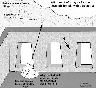
Sector II has a number of unusual features that appear to have had a ceremonial function. The main group is orientated to face Huayna Picchu at an azimuth of 50 degrees. The long axis of the group points to the Overlook Temple at 320 degrees similar to the long axis of Sector I. Near the summit of Huayna Picchu is the House of Three Windows, a shrine containing a replica stone closely resembling the Llactapata ridge that focuses attention on and is in alignment (230 degrees) with the Llactapata sites (Ziegler-Malville 2003).
Three windows shrine on Huayna
Picchu
A ritual
fountain/bath along with a pond suggests that water was an important design
element here as well. The small U shaped shrine (10) faces inward to the plaza
and hillside. Its focus is directed toward the spring and only water source for
area. The American anthropologist Susan Niles describes similar Incas sites as
water shrines or moyas (Niles 1999).
Features at
Sector 2 suggesting water ritual include fountains, a canal leading from the
only current water source in the area, a platform excavated from the hillside,
and the evidence of an artificial lake.
Buildings 1, 2
and 6 could have served as temporary lodging for important parties travelling
on official business, state sponsored pilgrimages or ceremonial processions to
and from Machu Picchu as a sort of high status shrine and
tambo with a ceremonial purpose.
Like Wińay Wayna on the eastern road to Machu Picchu,
the main Llactapata groups are situated several hours travel along the western
approach.
There are
similarities between the two sites. Wińay Wayna is at
an altitude of 2,600 metres and a distance of eight kilometres from Machu
Picchu. The Sector II group is at 2,700
metres and about the same distance by the original western road. Both are
designed around water features. Reinhard believes that Wińay Wayna was built as a ritual-stopping place along the road
to Machu Picchu. The similarities with Sector II suggest that it may have in
part served the same function.
Sectors I and II have certain architectural similarities, in particular the unusual division by sunken corridors, which suggest they may represent the principal upper and lower divisions, hanan and hurin, of the archaeological zone, in the duality common to Inca urban design and socio-political administration (Gasparini and Margolies 1980, Hyslop 1990). The Eastern and Western Sectors at Machu Picchu, separated by the main plaza are identified as such by Alfredo Valencia and others. (Wright-Valencia 2001)
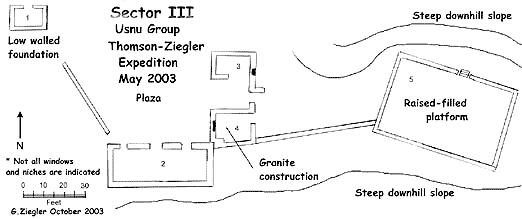
Sector III - The Usnu Group
Sector III plan
The relationship of Sectors I – III
Description
Located some 100
metres from the uphill side of Sector I and only 30 metres higher in altitude,
this sector is associated with Sector I.
Structure 2 is a
long building with three entranceways facing east into a small plaza. The roof
was probably gabled but considerable breakdown has occurred. No windows are
evident. It measures 90 feet by 20 feet with the back wall 9 1/2 feet high. The
alignment is cardinal north south.
Structures 3 and
4 border the north side of the plaza. 3 is low walled with the slope falling
off to the north and west leaving a higher north-facing wall with an outside
niche. Structure 4 is more interesting. Most wall stone is a shaped white
granite similar to that of Machu Picchu making the architecture unique for the
area. The material must have been imported from either near Machu Picchu, or
some closer isolated granite dike. A single internal niche faces east toward the
one entrance. A passageway leads down through a gateway between structures 3
and 4 to feature 5, the most important structure of the group, which appears to
be a Sacred Platform or
Usnu.
The
Usnu is a 60 feet
by 40 feet raised, earth filled platform, enclosed by a five feet high
retaining wall. It is connected to building 4 by a 60 feet long low wall. Stone
steps lead onto the platform from the northeast side. The platform is aligned
20 degrees by 110 degrees. and overlooks Sector I below.
Another low wall,
40 feet long, leads off from the northwest corner of building 2 at 330 degrees.
Beyond the wall is a low walled rectangular structure (1) that is similar in
size and placement to outlying structures at other sections. It may have been
built for a caretaker or attendant.
The main
buildings and plaza are aligned with cardinal directions. Johan Reinhard has
written of the importance to the Inca of cardinal directions, equinox
alignments and their unique relationship to sacred mountains at Machu Picchu (Reinhard
2002) Although alignments would somewhat differ, it follows that this may be
true for Llactapata sites as well. The
northwest wall of the plaza, aligned at 335 degrees, is in directional line to
the Overlook temple. However, it was not possible to establish whether the
temple can be seen from the plaza. A similar wall running out at an angle from
a building at Cota Coca creates a sight line to the water shrine
Pinchu Unuyoc near Choquequirao.
(Ziegler-Thomson 2002)
An important
feature is the large usnu
platform. The term has several meanings.
Usnu is used to describe a
stepped platform upon which the Inca was seated from an early description by
Guaman Poma (Poma
1956 [1613]). An
usnu has also
been described as a place to view sunset with markers on the horizon. (Zuidema
1986). The great usnu
of Cusco, Usnu Capac, had a central pillar for
astronomical sighting (Moseley 1993).
The name appropriately describes raised platforms associated with
ceremonial sites.
With an alignment
of 110 degrees and 20 degrees, the platform is orientated close to the December
solstice line for the rising sun of 112 degrees noted by Johan Reinhard for
Machu Picchu (Reinhard 2002). As no significant summits are close to this
alignment to suggest a topographic focus, nor does the platform align toward
Machu Picchu, it is possible that the primarily ritual activity related to the
December solstice. Overlook
miradores and raised platforms are common throughout the
region but few are of this large size. Only hill top platforms at Choquequirao
and Cerro San Miguel are larger (Lee 2000, Ziegler 2001, Reinhard 2002,). The
size suggests that this was a very important ceremonial location. Sector III
requires additional study.
There seems to have been an attempt to establish the main
sectors of Llactapata 1-3 along a direct
east-west line, as the centres of those sectors depart from that east-west line by less than 1/3 degree.
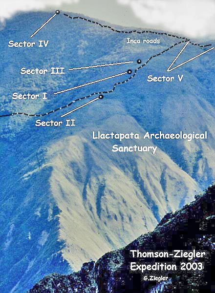
Sector IV - The Reinhard Group
Sector IV plan
During 1985
Johan Reinhard conducted an exploratory investigation of the upper regions of the
Aobamba drainage. He visited and surveyed the high site of
Palcay (3600 metres) previously documented by Bingham
(Bingham 1913). While descending down to the Urubamba Canyon, he surveyed and
reported the building now identified as Sector IV. (Reinhard 1990).
Following his description and map, the site was re-located where indicated on a lofty shoulder of the Llactapata ridge at 3000 metres altitude, among tall tree-ferns. The remaining walls are badly deteriorated. The main structure is a long (120 feet) narrow building with 12 entranceways spaced along the sides. No niches are visible. The building follows the slightly curved contour of a small hilltop.
A number of equally spaced
holes are centred along the inside floor.
All have been opened by treasure hunters,
huaqueros. They appear to have
been stone lined chambers similar to others that have been observed in the
Vilcabamba. (Ziegler 2001, 2002). Three smaller low-walled rectangular
structures are located nearby. The building is situated near the route of a
likely Inca road that connected Palcay above with
Llactapata and the main westward Inca road below.
Similar long structures with multiple entrances have been identified as meeting halls, kallankas, such as the largest building at Machu Picchu, located outside and above the main gateway (Wright-Valencia 2000). These large buildings seem to be located near or are part of a larger site such as at Choquequirao, Cota Coca and Machu Picchu. It would be unusual for a meeting hall to be placed as an isolated structure in a remote region.
Some long
buildings have been identified as storehouses.
Examples are a group between the upper and lower Plazas at Choquequirao
and a long isolated building with multiple entrances and windows at
Sapamarca. (Ziegler 2001)
Storehouses were
frequently placed in a high open area for ventilation and other reasons such as
at Ollantaytambo (Protzen1993). The holes or chambers in the floor present an
enigma. Reinhard thought the holes were dug by
huaqueros. However, several were now found to have
visible stone linings. From excavations
at Corihuayrachina similar chambers were found to contain simple offerings and
low status burials (Ziegler 2002).
It is interesting that the alignment of the
east wall is 40 degrees, creating a sight line to the summit of Huayna Picchu.
An azimuth of 340 degrees for the opposite or north end offers a sight line
down the Urubamba Canyon to the site of Sapamarca.
The building may well have been a storehouse, located below the frost zone on
the road to Palcay. Local residents may have used it
as a convenient mausoleum at a later date, during or following the decline of
Machu Picchu. The three low walled structures may have been simple wood-sided
huts for a caretaker family.
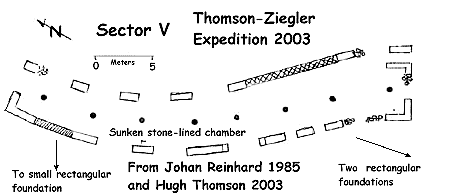
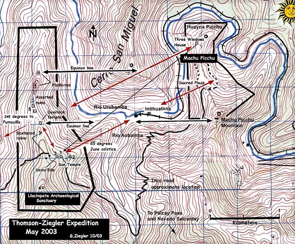
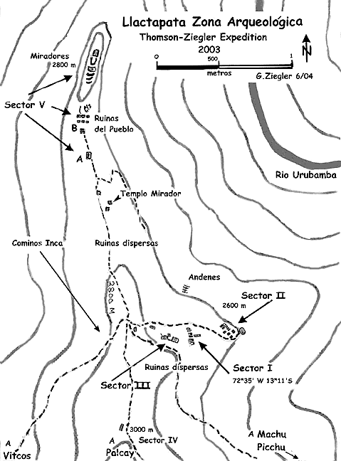
Sector V - Group A and Group B
This complicated
Sector encompasses a large area of the lower ridge dividing the Santa Teresa
Valley and the Aobamba drainage, terminating when the
two river merge in the Urubamba River and Canyon at an altitude of 1,500
metres. The ridge runs from 2,800 metres down to a partially clear saddle at
2,600 metres. From the saddle, the ridge rises steeply up into several rocky
crags with steep cliffs on either side before again plunging downward. The
upper portion is cloaked in heavy dense forest and thick, nearly impenetrable
vegetation. A rough trail reaches the
saddle from the Santa Teresa valley side. A seasonal hut and several cornfields
account for the cleared areas.
Four main groups were located and incompletely surveyed; Groups conjuntos A and B, the Overlook Temple and the crag top platforms. Several freshly dug holes indicated that the local farmer had visions of buried treasure. The central feature is the solitary, unique two story building perched on a ledge viewing Machu Picchu, first reported in 1982, and now described as the Overlook Temple. [3]
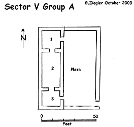
Sector V Group A
Group A: This feature is a rectangular walled compound kancha measuring 75 by 55 feet enclosing a long three room, badly crumbled building. The outside wall is six feet high and three feet wide of crude slab construction. The alignment is cardinal with east facing entranceways offering a sight line to Mt Machu Picchu.
Sector V Group B
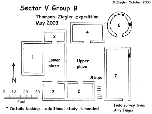
Group B:
Located two hundred metres down the ridge and at a slightly
lower altitude, this group of seven buildings is built upon a small hill. A central wall divides the group into lower
and upper sectors each with an internal plaza. The alignment is north south
with entranceways at buildings 1-5 opening into the two plazas. Building 6 is
round with an inside diameter of 16 feet. The entrance faces south. The north
wall has three niches. A single window faces east offering a sight line to Mt Machu Picchu.
The extent of scattered foundations and crumbled, poorly made walls suggest that the lower ridge was a settlement of low status workers. The gently sloping and level areas of the long ridge are well suited for agriculture as demonstrated by several recent cornfields located near the saddle. Although this needs considerable further study, two possibilities are that Groups A and B were either storehouse groups, qolqas, or administrative centres/residences for the local administrators or karakas.
These were hereditary heads of kinship
groups, ayllus, that worked and managed agricultural
lands. The duality of Andean social organization required two for each
settlement (Moseley 1993). If so, Group B could have housed the principal or
more powerful administer. The round house with window view of Mt. Machu Picchu
may have served a ceremonial function.
Additional study is needed.
Platforms and low walls on the rocky crags above may have offered a view to the east of Mt Machu Picchu Mountain, Mt Veronica and to the west of Mt Pumasillo. The summit of Mt Salcantay can be seen to the South. Reinhard and others have shown these mountains to be particularly important to the Inca. Of interest is that the crags lie exactly on the equinox line from near the summit of Mt Veronica. The line crosses the Machu Picchu Intihuatana and the summit of Cerro Miguel, which has a platform and upright marker stone on the equinox line (Reinhard 2002). The Sector V platforms may have been especially suited to respect sacred geographical features in combination with equinox alignment and other astronomical phenomena.
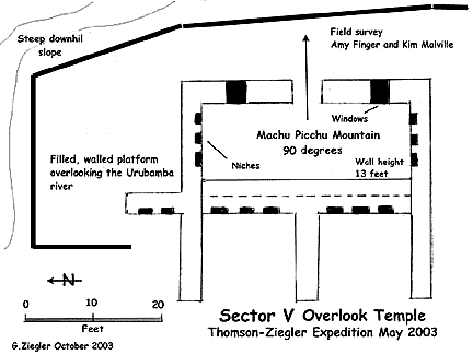
Sector V - Overlook Temple
Overlook Temple plan
On the lower ridge above groups A and B there is an unusual, solitary, two-story structure perched on the edge of a steep drop above the river some 1200 metres below. Construction is of the finest Vilcabamba style with larger blocks of shaped quartzite utilized for corners and doorjambs. The building contains 14 niches. The one entrance way and two windows open to a balcony or walled, filled platform providing an impressive view of Machu Picchu, the Veronica Range, Cerro San Miguel, Salcantay and the Urubamba River.
The west-facing wall has
two open chambers with niches, which look out on a broad gently sloping area
with no visible evidence of constructions. A short wall with two niches extends
out eight feet from the northwest corner creating an angled passageway leading
onto the front platform. Nearby, a walled path descends toward the Urubamba and
the riverside Intihuatana shrine.
The building is
cardinal aligned. Its eastern facade and doorway focus a sight line to Machu
Picchu Mountain in alignment with the
huaca site called the Intihuatana in the Urubamba Canyon
below. This is the line the sun would be seen to follow during equinox for a
viewer at any of the three locations. The ice summits of Veronica and Salcantay
are also visible. The summit of Cerro San Miguel lies at an azimuth of 60
degrees from the temple. The sun would rise over Huayna Picchu during the June Solstice
and be seen close to the summit of Cerro San Miguel when first viewed. Both
June solstice and equinox ceremonies could be conducted from the temple.
An unusual
feature of the location of Overlook Temple is that it lies close to the
extension of the long axes of the Llactapata Sun Temple (Sector I), the
possible moya
of Sector II, and the usnu
of sector III. A person standing on the courtyard of the Sun Temple facing the
June Solstice sunrise would find the Overlook Temple to be 90 degrees away from
the sun. Conversely, a viewer at the Overlook Temple would have the Sun Temple
at a right angle to the rising sun during the equinox.
This solitary,
unusual structure, first reported in brief outline in 1982 but not mapped,
seems to have been a most important ceremonial feature of the Llactapata
archaeological zone (Drew 1982), The setting, construction, design, external
niches and platform mirador
suggest that the building had an important ceremonial purpose.
Sight lines to
sacred topographic features in relationship to equinox and solstice alignments
suggest that solar rituals and ceremonies were primary activities. A sight line
orientated directly east, passing through the
huaca Intihuatana at the sacred
Urubamba River, Wilcamayu, to Mt Machu Picchu is particularly
significant. The Intihuatana site has yet to be studied. Reported by Bingham,
the feature has not been surveyed (Bingham 1913).
Another east-west alignment involves the isolated structure that we have called the Overlook on the lower Llactapata ridge (Sector V: Figure 5). Its eastern balcony faces Machu Picchu peak and provides a view of a stone shrine or usnu down in the Urubamba Canyon that Bingham had called another intihuatana. The Intihuatana site consists of a large sculpted rock, a platform, water channels, waterspouts and basins.
A displacement of the
shrine by a few meters to the south would cause the Overlook to disappear
behind the cliffs of the canyon when seen from the Intihuatana, suggesting the
importance of inter-visibility. There are other visual linkages between
structures in Llactapata and Machu Picchu. The Priest’s House of Machu Picchu
is oriented toward Llactapata and the setting sun at December solstice10.
The house of three windows on Huayna Picchu faces the Llactapata ridge and
contains a huaca
that replicates the ridge.
However, the location at almost the mid way point between the Overlook Temple and Machu Picchu Mountain would allow an observer to view sunrise near the Mountain, and then sunset near the temple during equinox. Reinhard and others have demonstrated the importance of Mt Machu Picchu to the builders of Machu Picchu (Reinhard 2002, Ziegler-Malville 2003).
The placement of the Overlook Temple in relationship to these important features gives it special significance.
overall map including Machu Picchu
photograph of Llactapata hillside showing archaeological zone
The relationship of Sectors I – III
Llactapata site plan
Site Summary
Llactapata Archaeological
Zone
CONCLUSIONS
The research
expedition revealed Llactapata to be a far more substantial site than has
previously been realised
As group after
group appeared, some uncovered after five centuries of concealment it became
apparent that this was far more than a small compound of buildings described by
Hiram Bingham in less than a paragraph.
There are
parallels to one of Bingham’s most important discoveries, Espíritu
Pampa in the Vilcabamba, which he only partially uncovered
in 1911. Only later, in 1964, were
further sectors revealed and its true significance established, as Vilcabamba
La Vieja, the last refuge of the Inca.
Likewise
Llactapata, the supposedly insignificant ruin with the unassuming name, ‘high
town’, is of much more importance than had been thought.
Many groups and
features at Machu Picchu have been identified as having alignment to
astronomical phenomena or specific topographic features. (Dearborn 1987,
Reinhard 2002). Johan Reinhard has suggested that Machu Picchu was located,
designed and functioned as a ‘sacred centre’, with a unique convergence of
geographical features, sacred mountains and the Urubamba River giving
astronomical and cardinal alignments (Reinhard 2002). As a closely related satellite of Machu
Picchu, this interpretation applies well to the Llactapata site.
Solstice-equinox
orientation in relationship with alignments on Huayna Picchu and Mt Machu
Picchu indicates that adoration and ritual focus on these special mountains and
the sun may have been the primary purpose at Llactapata. If the Sector I group
is a sun temple as we suggest, its location, situated to view the sun rising
over the Sacred Plaza, midway between the two peaks during the June solstice,
gives great ritual importance to the site.
The solitary
Overlook Temple seems to be both a June solstice and an equinox feature, placed
to view the sun rising near the summits of Cerro San Miguel and Machu Picchu
Mountain. The ridge top platforms also
appear to have an equinox purpose from their placement directly to the west of
Cerro San Miguel and Machu Picchu.
The
Usnu Group, the newly reported Sector III, may also have
had an equinox purpose, as the main structures are cardinal aligned. However, the large, raised usnu is the principal ceremonial feature.
The alignment suggests that the main function may have been December solstice
activities. The platform would also have been used for different astronomical
and ceremonial events.
An alignment
relationship with the Overlook temple and sight lines to and from the Sun
Temple, Usnu Group and Sector II is a phenomenon,
which we suggest, was by design. At
Machu Picchu every feature or construction appears to be planned and aligned
with a purpose. We suggest that the
ceremonial groups and features at Llactapata were placed and built in careful
consideration of geo-spiritual and astronomical relationships in conjunction
with Machu Picchu. Llactapata was part
of a carefully designed network of interrelated administrative and ceremonial
sites supporting the regional administrative and ceremonial centre at Machu
Picchu.
This should be
seen in the light of recent work by John Rowe, Richard Burger and Lucy
Salazar-Burger, which places Machu Picchu in the context of Pachacuti’s
personal estate (Rowe 1987, Burger & Salazar-Burger 1993). The high status
architecture found not only at Machu Picchu but throughout the Vilcabamba and at
sites along the upper Urubamba valley is a reminder of the use of this area for
royal estates by the Inca nobility (Burger & Salazar-Burger 1993, Niles
1999).
Llactapata is an
important staging post on a network of roads extending from Cusco to
Vitcos. Our
investigations have identified the remnants of an Inca road at Llactapata
connecting with the ‘drawbridge’ route west from Machu Picchu. Earlier
explorations by Hyslop, Lee, Thomson,
Ziegler and
others have traced roads from the important Vilcabamba sites of
Vitcos and Choquequirao (Hyslop
1984, Lee 2000, Thomson 2001, Ziegler 2001). A major road network connecting
with extensive Inca controlled regions to the west reinforces the idea that
Machu Picchu was the spiritual and administrative hub of a network of roads,
regional settlements and state controlled commerce as suggested by Ann Kendall
and others (Kendall 1988).
A large staging
area and meeting hall outside the main gate and a number of
qolqas indicate that Machu Picchu
may have been a collecting point for goods arriving from the Vilcabamba to be
sent on to the capital or for other distribution. If so, Llactapata would have
been an important resting place and roadside shrine for important official
parties on the road to Machu Picchu and beyond. We have discussed the
similarities of Sector II with Wińay Wayna, which has
been identified as a water shrine and resting-place on the eastern road (the
so-called ‘Inca trail’). The Sector II group likely served a similar purpose as
a sort of high status tambo
with seasonal ceremonial activities.
The architectural
similarities between Sectors I and II reflect the division of the site into
hanan and
hurin sectors
common to pan-Andean societies (Gasparini &
Margolies 1980, Hyslop 1990).
An area of about
one square kilometre suitable for agriculture and the abundance of poorly made
structures on the lower ridge in Sector V indicate that quantities of corn and
other crops were grown here. The American hydrologist Kenneth Wright calculates
that the agricultural areas at Machu Picchu could only have produced enough to
feed 55 people. He estimates that the
site housed 300 permanent residents (Wright & Valencia 2000). The
Llactapata crops may have been a useful way to supplement food production at
Machu Picchu.
The number of
simple foundations suggests that the area was also a low-status settlement that
may have housed a population of workers in support of activities at Machu
Picchu, just as the settlements in the Cusichaca
valley are thought to have been (Kendall 1988).
We have estimated the distance along the Inca road to Machu Picchu to be
less than eight kilometres.
The
identification and study of the Llactapata archaeological area adds
significantly to our knowledge and understanding of Machu Picchu as the hub of
a complex neighbourhood of carefully placed interrelated administrative and
ceremonial sites reaching outward toward distant imperial Cusco and the far
Vilcabamba.
The
architecture and dramatic landscape of Machu Picchu have always suggested that
for the Inca it was a place with considerable depth of meaning and sacred
power. Llactapata adds to its significance providing a sun temple, similar to
the Coricancha, from which the Pleiades and the June solstice sun rise over
Machu Picchu.
Acknowledgements
BIBLIOGRAPHY
This is a longer English version of the article that was first published
in the Revista Andina (2004, #39), with the title
‘El redescubrimiento de Llactapata,
antiguo observatorio de Machu
Picchu’; the article was accompanied by
peer-reviews of the findings by R. Tom Zuidema, Jürgen
Golte, Peter Kaulicke and
Vincent Lee.
[1] It should not be confused with the site of Llactapata or Patallacta which lies at the start of the so-called ‘Inca Trail’ at Km 88, further up the Urubamba river, which was investigated by Ann Kendall and the Cusichaca Project in the 1980s (Kendall 1988) [2] The Salcantay valley is now more commonly called the Santa Teresa valley. [3] Gary Ziegler, John Leivers and a small reconnaissance party returned in May 2004, and reported two additional groups totalling more than 30 structures near the Overlook Temple. These groups require surveying and study (Ziegler 2004).
|