| Sending the slow,
cumbersome seaplanes to the Antarctic to fly in a frigid, hostile
environment seemed totally irrational at first thought, however sense
could be made from such a decision when one considered their long-range
flight capabilities as well as their ability to operate in open sea
conditions around the entire continent rather than restricted to land-based
operations.
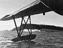
The PBM Martin Mariner seaplane was satisfactorily equipped
to meet the many technical requirements of such an operation.
The
planes had served admirably in many open sea recoveries of downed
pilots. The VH-4 Squadron was often involved in semi-open sea maneuvers
during OPERATION CROSSROADS. However, neither the aircraft
nor the crewmen were experienced and properly equipped for the extreme
weather conditions which awaited them. For example, the planes were
lacking adequate deicing and navigation equipment.
But the pilots
and crews of VH-4 were otherwise well experienced and available. The
plane commanders were certainly qualified and would adapt quickly
to flying conditions in the Antarctic.
They would be
subjected to numerous intangibles upon reaching the Antarctic. Since
most of the interior of the continent was uncharted, elevations
of the terrain was, for the most part, an unknown. Couple that with
poor weather forecasting and you have a recipe for exceptional danger.
A PBM crew flying off the USS PINE ISLAND
(Eastern Group) would experience the unforgiving flying conditions
firsthand as they
crashed on Thurston Island,
resulting in the first loss of American life in the Antarctic.
Antarctica
is known to have the highest winds on the face of the earth and
weather conditions can change dramatically in only minutes.
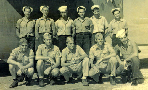
Since the squadron
was due to be decommissioned, pilots and enlisted crew vacancies
were not refilled as the squadron slowly disbanded. As a result,
when the squadron touched down in Hawaii, there were only 10 pilots
and approximately 50 crewmembers available for the "volunteer"
expedition.
When questioning the alternative to accepting the "voluntary"
assignment the answer was,
"probably reassignment as a replacement
pilot or crew to a squadron in the Far East."
Nine pilots and
15 crewmembers eventually volunteered.
They may not have been completely
willing, but they nevertheless were true volunteers in every sense
of the word. Classification of OPERATION HIGHJUMP
was so sensitive that the pilots and crew were instructed to keep
the details of their assignment under wraps, even from their wives
and family members. Most, if not all of the men, chose to ignore
this order.
After the decommissioning
of VH-4 in San Diego, California, the OPERATION HIGHJUMP
volunteers reported to COMFAIRWING 5 at Naval Air Station Norfolk,
Virginia on November 1, 1946 to begin preparations for the expedition.
Demands and priority for sophisticated equipment for OPERATION
HIGHJUMP apparently was never passed down to the logistics
people at the naval air station.
The highly classified nature of
the expedition only compounded the problems. Somehow news of the
"classified" expedition was leaked to the newspapers since
the local papers announced that the Western Group was on its way
to the Antarctic. Although a breach of secrecy, once this news hit
the papers equipping of the expedition picked up steam.
Meanwhile,
"Training
was constant and intensive from November 5 through November 23 with
flight crews attending numerous classes on aerial mapping, tri-metrogon
photography, cold weather operations in seaplanes, flight planning,
polar grid navigation and the use of the astro compass. Technical
training for the radiomen and radar operations was also accomplished."
(Captain Robert H. Gillock, USN retired, Captain Paul J. Derocher,
USN retired, Mariner/Marlin Newsletter, February 2001, pg. 26).
All of the men were trained in the use of survival gear as sleds,
axes, stoves and tents were to be carried aboard the aircraft while
flying their missions.
The three PBM-5
"Mariners" were delivered to the group in mid-November
and flight-tested. Meanwhile, upon completion of their training
the men were issued standard navy heavy-weather winter flight gear
together with charts of the Antarctic.
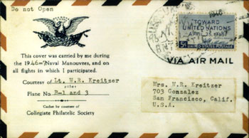
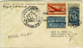
They were assigned to the
USS CURRITUCK, which together with the
USS
HENDERSON (Destroyer) and
USS
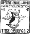
CACAPON (Fleet Oiler), would become Task Group 68.2,
a.k.a. the Western Group. On November 26, all three PBM's of the
Western Group departed NAS Norfolk for San Diego via NAS Pensacola
and NAS Corpus Christi.
Four days later the planes arrived in San
Diego and on December 1, the final PBM was hoisted aboard the USS
CURRITUCK. Their participation in the expedition would begin
the next day when the ship got underway for the southern polar region.
Their mission was to explore and photograph the eastern longitude
of Antarctica.
|
|
The first
flight of the Western Group was made on December 24, 1946.
On January 1, 1947, a 9.2-hour flight was made to the vicinity
of the magnetic South Pole. However, the special 3-phase gyro
used for navigation was incorrectly wired.
Fortunately, the
USS CURRITUCK picked up the aircraft's emergency IFF signal which was responsible for guiding the aircraft
back to the ship.
Upon returning to the ship it was discovered
that the aircraft was some 100 miles in error. Early on in
the expedition, the planes of the Western Group were dispatched
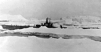
to help save the submarine
USS
SENNET.
A participant with the Central Group,
she was the first submarine to venture into Antarctic waters.
Squeezed by the ice and threatened to be crushed, the PBM's
would search for leads to open water.
The PBM's were unsuccessful
in their search, however the USS SENNET was
eventually freed from the grips of the ice, escaping to open
waters in the Ross Sea where she would serve as a weather
reporting station.
|
The pilots quickly
adapted themselves to flying in the Antarctic.
Careful attention
was paid to making landings so that no undue stress would be placed
on the aircraft. Takeoffs and landings were often made parallel
to the ocean swells and all takeoffs were JATO (Jet-assisted takeoff)
assisted. Takeoff weight could not exceed 22 tons as that was the
maximum weight the hoisting hook on the USS CURRITUCK
could support. Upon landing, the crews worked like a well-oiled
machine in their ability to retrieve and hoist the plane onto the
ship within a matter of minutes.
The Western
Group was pressured to get to their Antarctic base of operations
in the shortest possible time. Most of what is told here was originally
considered hearsay, but was later established as fact.
The Western
Group's primary objective was to explore and photograph, by air,
as much of the Antarctic continent within its operational area as
possible. This region, never before seen by human eyes, would be
claimed by them for the United States of America.
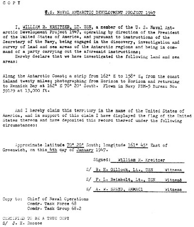
"Flying within
predetermined grids, contiguous territorial areas were identified
by their coordinates and recorded and claimed for the United States
by the patrol plane commander. Each claim was witnessed by three
other crew members.
After a copy was made for transmittal to the
State Department, the original copy of the claim was placed in a
waterproof container to which approximately 10 feet of line and
a small United States flag were attached. The canister and flag
were then thrown overboard to land on the claimed territory, the
crew being careful to avoid having the line and canister entangle
in the aircraft's tail."
(Captain Robert Gillock, USN Ret.,
Captain Paul Derocher, USN Ret., Mariner/Marlin Newsletter, February
2001 pg. 27).
The pilots and
crews of the Western Group accomplished a great deal during OPERATION
HIGHJUMP.
Unlike the crash and tragic loss of life on PBM-5
George One (assigned to the USS PINE ISLAND in
the Eastern Group), this group experienced no accidents.
Accomplishments
included:
-
Nineteen
claims of previously unexplored territory made in the name of
the United States. All claims have been recorded by the US State
Department and are now on file in the National Archives.
-
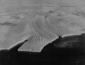
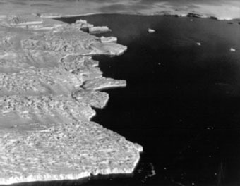
A
total of 405,378 square miles of Antarctic were photographed.
-
A total
of 36 flights were launched from the open seas off the Antarctic
ice pack.
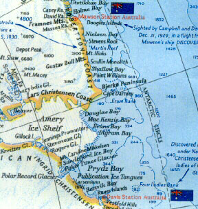
GEOGRAPHIC
NAMES IN ANTARCTICA
NAMED AFTER HIGHJUMP PILOTS & NAVIGATORS
1946-47
|
PILOT
/ NAVIGATOR
|
GEOGRAPHICAL
NAME
|
SOUTH
LATITUDE
|
EAST
LONGITUDE
|
|
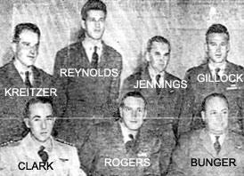
Bunger
|
Bunger
Hills
Bunger Lakes
Bunger Oasis |
66°
17'
66° 17'
66° 17'
|
100°
47'
100° 47'
100° 47'
|
|
Gillock
|
Gillock
Glacier
Gillock Island |
72°
00'
70°
26'
|
24°
08'
71°
52'
|
|
Gist
|
Gist,
Mount |
67°
21'
|
98°
54'
|
|
Jennings
|
Jennings
Glacier
Jennings Lake
Jennings Promontory |
71°
57'
70 ° 10'
70 ° 10'
|
24°
22'
72°
32'
72°
32'
|
|
Kreitzer
|
Kreitzer
Glacier
Kreitzer Bay
Kreitzerisen |
70°
22'
66° 30'
72 ° 13'
|
72°
36'
109°
30'
22°
10'
|
|
Reinbolt
|
Reinbolt
Hills |
70°
29'
|
22°
30'
|
|
Rogers
|
Rogers
Glacier
Rogers Peaks |
69°
59'
72 ° 15'
|
73°
04'
24°
31'
|
|
Stevenson
|
Stevenson
Glacier |
70°
66'
|
72°
48'
|
|
Reynolds
|
Reynolds
Trough |
66°
17'
|
100°
47'
|
GEOGRAPHIC
NAMES IN ANTARCTICA
NAMED AFTER HIGHJUMP CREWS
1946-47
|
CREW
#1
Pilot William J. Rogers, Jr.
|
GEOGRAPHICAL
NAME
|
SOUTH
LATITUDE
|
EAST
LONGITUDE
|
McKaskle
Statler
Mistichelli
Maris
Hargreaves
Peterson
|
McKaskle
Hills
Statler Hills
Mistichelli Hills
Maris Ntk.
Peterson Glacier
|
70°
00'
69° 50'
70° 02'
111° 00'
69° 59'
|
73°
00'
73° 10'
72° 50'
65° 20'
73° 10'
|
|
CREW
#2
Pilot David E. Bunger
|
|
|
|
|
Fuller
Draves
Countess
Smith
Booth
Garan
|
Smith Ridge
|
70°
02'
|
72°
50'
|
|
CREW
#3
Pilot William R. Kreitzer
|
|
|
|
|
Preston
Spayd
Branstetter
Thil
Whisnant
Ellis
|
Preston
Pt.
Spayd Island
Branstetter Rocks
Thil Island
Whisnant Ntk. |
70°
17'
70° 33'
70° 07'
70° 08'
70° 00'
|
71°
45'
72° 12'
72 ° 40'
72°
35'
73°
05'
|
|