|
by Joseph P. Skipper from MarsAnomalyResearch Website
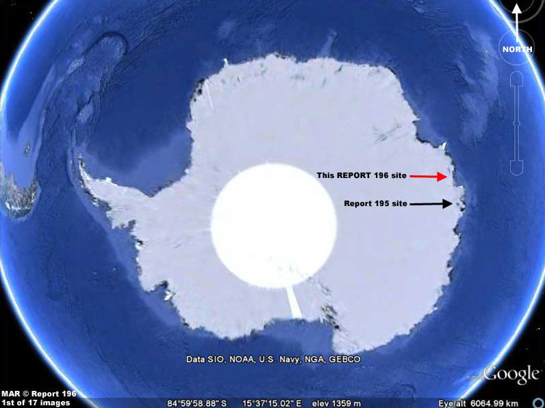
Report #195
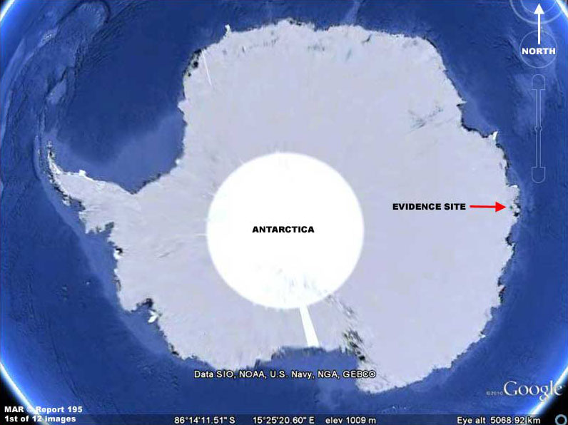
ANTARCTICA MYSTERIES 1
When zooming in on this site in Google Earth, one will encounter a narrow pale blue strip at this location within which the evidence reported on here resides.
That pale blue strip is a corridor of high
resolution surrounded by an extensive sea of smudge obfuscation and
that narrow higher resolution strip is the sole reason why we are
able to view just a little truth here.
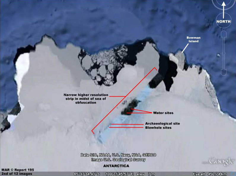
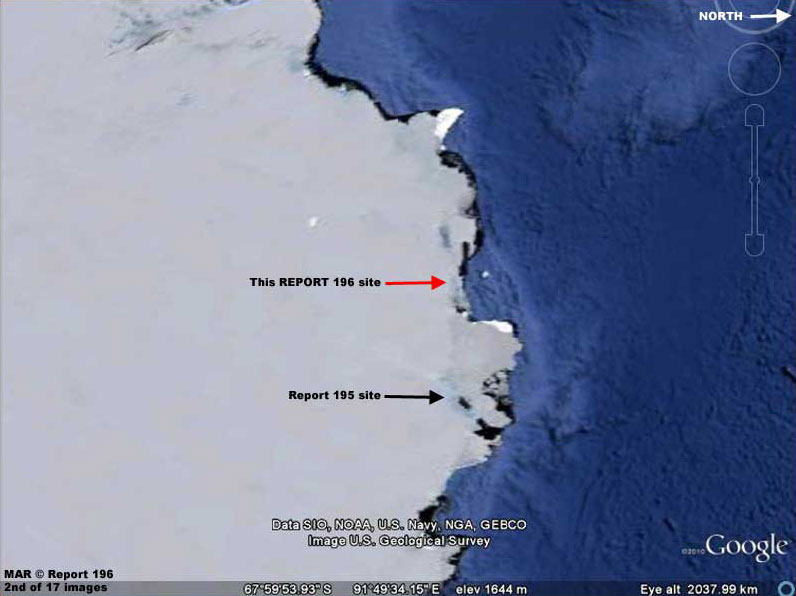
The above 2nd image is another context locator image but this time closer and showing what the pale blue narrow strip of higher resolution looks like and the location of the main evidence sites within it.
If the whole of the Antarctica continent was revealed at this kind of higher resolution, there is no telling what many kinds of truths would be revealed to us in the public.
Further, one can't
help but get angry when one realizes that we in the public treated
as a bunch of dummies are otherwise disrespectfully fed a load of
unmentionable material even though we paid for the real thing but
certainly aren't getting that in return.
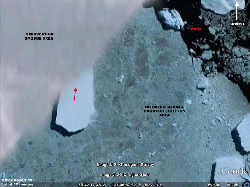
The above 3rd image is an example of what I mean.
The white blank smooth area in the upper left corner of the image is smudge image tampering obfuscation as viewed relative to and side-by-side with a relatively much clearer not obfuscated right portion of the image.
Note the sharp straight boundary between the two fields.
Note how a
portion of the big rough chunk of broken ice casting a dark shadow
and with the red arrow on it disappears up under this smudge coating
and how nothing more of it, not even a suggestion of it, can be seen
through the smudge demonstrating just how thick and obscuring the
smudge really is.
However, the above A-B
comparison and ruler straight boundary reveals the real truth as to
the presence of the obfuscation and this comes to us only because
someone by mistake or intent (rebels within?) allowed this narrow
satellite strip of truth to be included and come through to us.
Be glad of it because it is also causing the ice to be less sunlight reflective compared to the big elevated iceberg chunks also present.
This
slight darker sunlight absorbing rather than sunlight reflecting
quality contributes to our being able to see better detail rather
than it being washed out in white color.
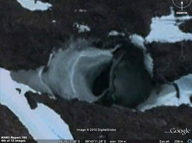
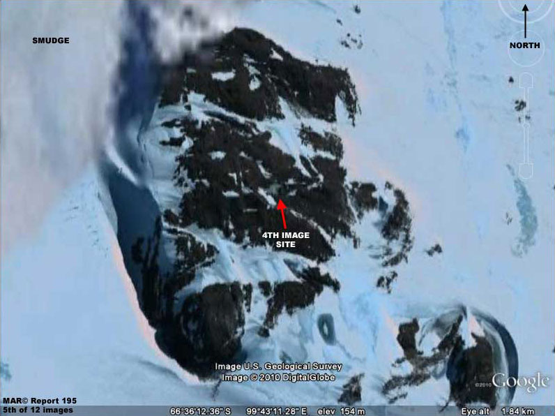
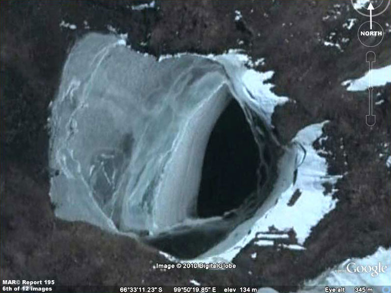
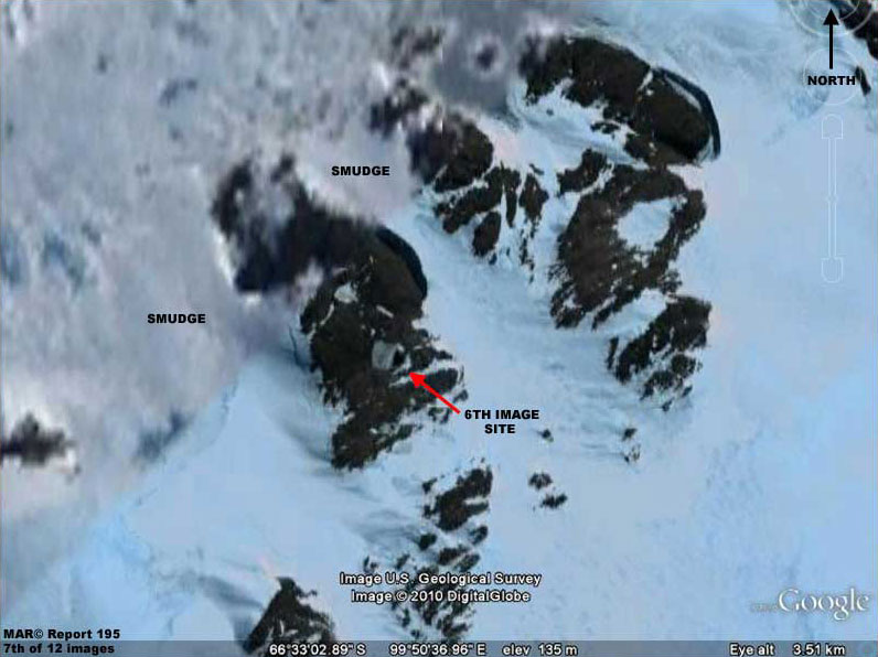
The above 4-5th and 6-7th image sets are of the same type of evidence in two separate locations not very far from each other in this narrow corridor of Google-Antarctica imaging truth.
For the
lack of a better term I've called these two sites "blowholes" and
their general location is in the labeling in the 2nd image in this
report. However, blowhole is misleading as you will see below.
Also note that
this ice on the left side has a slight greenish tint to it as
compared to the rest of the snow/ice in the hole's general vicinity.
This indicates that the source of this ice on the left is from
within the hole as compared to the other vicinity ice which is much
more likely surface snow/ice in origin.
If
so, it could be that heated water welling up from below but not
really fully venting may on occasion rise and push into the
depressions and then drain back in the hole leaving water behind on
the left side to shortly freeze into the slightly green tinted ice.
Unfortunately, this straight down satellite view doesn't allow us to
determine if this possibility may be so.
It is also possible that they are permanent but
camouflaged exit points in rocky terrain for some solid wide but
flattened objects exiting from underground to the surface environs
always in the same direction and via passage first through the water
and then up in the air carrying water shedding off the object always
dropping off in the same place on the hole left side.
At this
point there's just enough truth for it to be really anomalous and
suspicious. The key to the above Antarctica evidence is inland fresh
water presence in a liquid unfrozen state and the next evidence
below will be of this as well.
Of course most of that is suppose to be in the form of snow/ice solid particulates laying around sometimes thousands of feet deep on as well as offshore of the continent.
You should know that the average
temperature in the Antarctic is –49ºC with the coldest temperature
on record and the coldest on Earth being –128.6ºF or –89ºC. In
other words, its very cold and most of the time far below the
freezing point of fresh water.
Note
that these temperatures are above the freezing temperature of water
at sea level but remember that such "warm" temperatures can last for
only a few weeks with little impact on large bodies of ice.
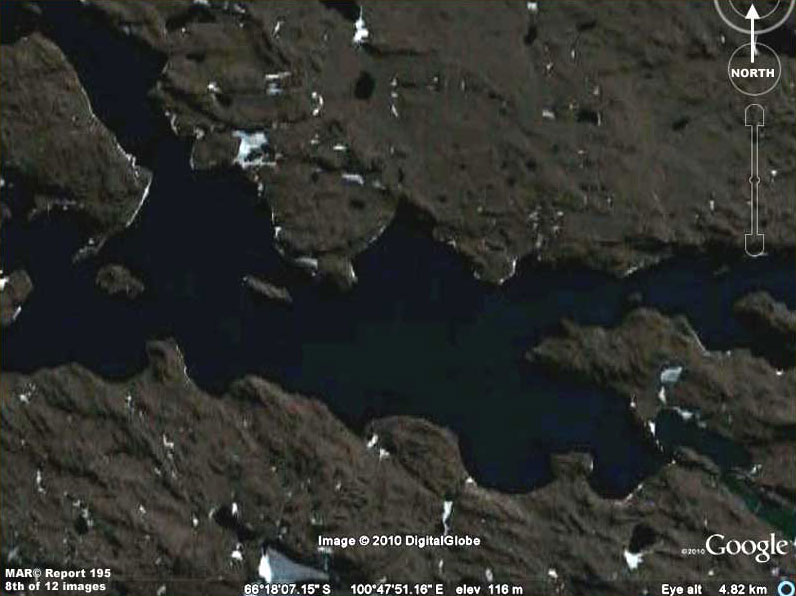
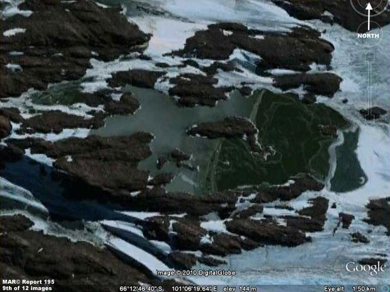
With that said, the above 8th image demonstrates a considerable size inland body of green tinted water in a liquid state embedded in elevated rocky terrain.
Note that there is no floating ice and only very small residual patches of snow/ice in terrain depressions around the site. That is very significant. Further, this is just a single sample and there is many times more of this same unfrozen liquid water evidence north of this point in this rocky terrain not shown here.
There is so much in fact that incredibly it all
represents an extensive network of mostly interconnected and mostly
navigable large water ways.
Also,
since there is hardly any ice presence even right at the lake
shorelines, we can assume the fact that it is not frozen over likely
means that this is deep water right up to the shorelines and perhaps
even lightly geothermally heated from below over a large area.
Obviously, the temperatures in this general area may be cold from
our point of view but the visual evidence here clearly demonstrates
that it is just not cold enough to support extensive snow/ice
presence no matter what is "suppose" to be the case in Antarctica.
If that suspicion is true, then someone has allowed us to
see the liquid fresh water sites but anything more than that is
apparently taboo.
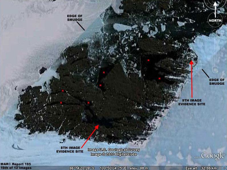
On the other hand, the above 9th image evidence is located over on the right edge area of the rocky terrain going out into snow/ice fields.
It demonstrates what clearly appears to be green tinted
surface water shallows also in a liquid state. Note that the left
side of the water site is shallow liquid water while the right side
seems to be a darker tinted green and likely biological growth of
some kind on wetlands associated with the water site with the growth
doing its conversion of sunlight to chlorophyll thing.
I've included a view of this evidence because the water is
unmistakable even in outer terrain areas like this and this site
also seems to present the added bonus of living bio-life evidence as
well on dryer ground.
The above 10th image serves as the context locator image for the 8th and 9th image's liquid surface water site evidence pointed out with the red arrows.
The many small red "X's" in the image represents a
sampling of the other largest water sites. In addition, there are
many lakes and entirely landlocked smaller bodies of liquid water
that are present in this area. I have not bothered to point out or
document here in this reporting because it would take just too many
images.
It may be that the external
weather temperature has not warmed so much as the land itself geothermally from below (?) resulting in melt and floating ice
breaking up.
Who do we thank, aliens or rebels?
This seems like a much more practical location for a permanent settlement supplied by air with a real landing strip.
Indeed, it you choose to close
inspect this area in Google Earth to confirm my findings here, there
is much here in this rocky outcrop area that is very strange looking
and therefore speculative and especially in the upper environs.
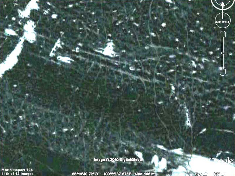
The above 11th image is a sample of some of this strange looking evidence looking very much like a lot that I've seen on Mars.
In
this image it is a dense tangled web of crisscrossing ribbons that
appear to exist on formerly wet fresh water site bottoms that are
now exposed to the air.
Also, in other nearby locations these wandering type continuous ribbons seem to connect and/or bridge between multiple very white fresh water ice masses scattered at random throughout the terrain as though they were paths created by something purposefully accessing the fresher whiter ice not suffused with the green tint.
In other cases, the irregular but
continuous ribbons also seem to serve as dams blocking floating ice
and forming enclosures with floating ice sections in them. Someone
managing ice chunks?
The resolution is great enough in this strip to raise
more questions but it is not good enough to answer other questions.
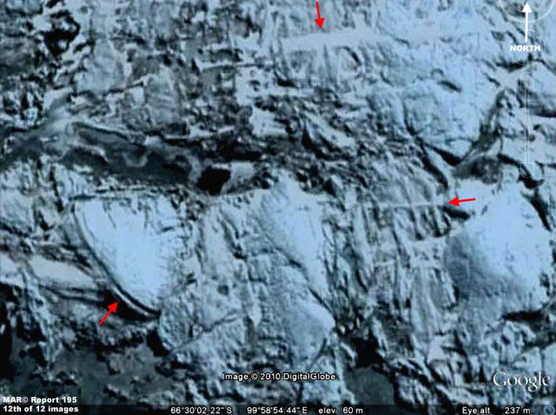
The above 12th image is in my opinion an evidence debris field site located just north above the 4th-7th image evidence sites and well below the many fresh water sites area.
Now let's understand that
this evidence is very suggestive rather than in any way definitive.
The red arrows point to some of the more suggestive evidence.
Is that giant rounded object in the lower left the remains
of the leading edge of a partially burled disk type craft or some
other tremendous rounded structure that met its fate in some ancient
cataclysm?
On the other hand, who would have ever expected to find in
Antarctica the coldest place on Earth a very large site literally
littered with deep fresh water in a liquid state? Is it a lost world
or just someone else's world?
However, my irrelevant personal desires
aside, make no mistake about it, here's the bottom line with this
hard visual evidence from Google Earth.
As damage control
they will be trying to convince us that this is just the result of a
"natural" underlying geothermal hot spot in the land that is causing
these obvious very isolated warmer conditions and that such sites
are extremely rare. Such an explanation will to the innocent likely
sound fairly reasonable and many will accept it mostly because they
want to.
Who would want to explore a frozen continent from the bases that we do have established where one is freezing one's buns off and it is life threatening deadly to go outside without extreme cold weather gear on?
Does this make any sense to you?
What is it that someone doesn't want us to see in
Antarctica? Why is it necessary to obscure most of an entire
continent in the satellite imaging rather than just some isolated
places? Remember, this is a large continent and not just an island
at the lower end of this world.
Further, although this is officially denied, it has been rumored that two atomic blasts were set off some where at or near Antarctica back in those post WWII times. In fact, although I didn't understand the significance of this at the time some years ago and didn't preserve it, I've seen pictures that included a fleet of ships in the foreground, a completely snow and ice covered landmass and mountain range in the far background, and an unmistakable atomic blast between the ships and the landmass.
The presence of a high
mountain range suggested Antarctica.
It's also a huge expenditure
of money, materials, and man power post WWII (with USA citizens in
lean times economically recovering from the war effort) to allegedly
test military post war cold weather military operations in case of
future war with the old USSR and/or investigate the frozen desolate
home of a bunch of cold hardy seals and penguins or even a few
isolated diehard freezing Nazis.
If so, the continued obfuscation of Antarctica in the satellite imaging into the present tells us that control of the continent was likely NOT established by this military operation.
Further, if the story of atomics being used is true, it suggests
that who ever is there is able to withstand the use of atomics, were
not impressed, and perhaps we've had to accept some compromises with
respect to who controls the bulk of this land?
Could it be that someone else not us
right here on Earth is calling the shots in this land confining our
settlements to its periphery?
So
I suggest that all of you around the world who can please go quickly
to this spot in Google Earth (following my visual directions) to
download, document, and preserve this evidence before it can be
sanitized following this reporting.
It appears that the site of this evidence and its year round unfrozen fresh water in a liquid state is named Bunger Hills and was first discovered and filmed by a seaplane flight in 1947 commanded by Navy Lieutenant David E. Bunger surveying and filming as part of the infamous military 1946/1947 Navy expedition in force named US Navy Operation Highjump overall commanded by Rear Admiral Richard E. Byrd, Jr.
It seems the plane landed on the water confirming temperatures of 38º and that it was fresh water. Note that I've included duplicating material video links below containing 1940s film of this discovery just in case some links are lost in the future.
The site is located about about 220 miles or 350 km from the Russian Mirny Station to the west that is part of my Report 196.
I've checked the coordinates and the Bunger Hills location is the same as that in my report.
Of the great many lakes in this area, the largest and longest is Algae Lake (aka Lake Figurnoye) some 16 miles or 25 km long and up to 449 feet or 137 meters deep.
Admiral Byrd described the area as,
Also, apparently the Russians attempted to establish a small
station on this site in 1956 named Oazis later turned over to Poland
in 1959 and renamed Dobrowolski Station none of which amounted to
much and eventually was abandoned.
I'm not going to bother with it but if someone were to go
to the trouble of making a very careful survey of the entire site in
this reasonably good imaging and no evidence of the Oazis/Dobrowolski
Station sites were revealed, I would suspect the presence of careful
image tampering inadvertently covering this visual information. Report #196
ANTARCTIC MYSTERIES 2
In doing so I'm trying to show you via hard verifiable visual evidence that you need to pay attention to the reality that even planetary issues we all thought were long settled as much as decades and generations ago right here on Earth itself have also not been accurate.
In fact, we may have been sold a secrecy bill of goods all over the place as the few benefit from the long conditioned ignorance of the many for control purposes and that this corrupts the very heart of our world and its populations.
Sorry if this intrudes where some do not wish
to go but there it is.
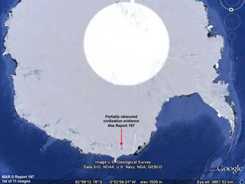
Meanwhile, the above 1st and 2nd images show the location of the evidence general site in this report as well as relative to the location of the evidence in the previous Report #195.
As you can
see, the sites are relatively nearby each other. In this report, the
location is also the site of the originally Russian Mirny Station at
the Davis sea coast. That in turn is supposed to be the coastal
staging point for supplying the Russian Vostok Station located deep
in the interior of the Antarctic continent some 1400 km from the
coast.
Deep under Vostok Station and under very deep ice is
Vostok Lake.
Some believe that the true purpose of the military force was chasing after escaping Nazi forces while others also bring aliens into the issue, both officially denied.
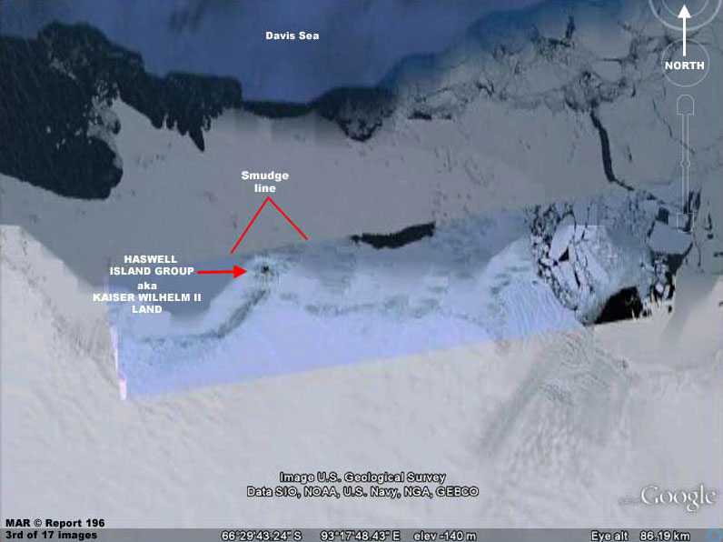
You should know that the
general area where Mirny Station is located was also first
discovered in 1902 by the German Gauss Expedition and named Kaiser
Wilhelm II Land suggesting at the least some German early knowledge
of the area dating back to that time before WWI and WWII.
You'll be the judge as to whether that poor
resolution visual evidence may suggest civilization evidence and why Mirny Station was at some later point moved inland off the bare ice
sheet but apparently avoided moving onto Haswell Island even though
it has more elevated rocky mostly ice free terrain complete with
fresh water in a liquid state and strangely bypassing it to settle
beyond it on the more difficult ice terrain.
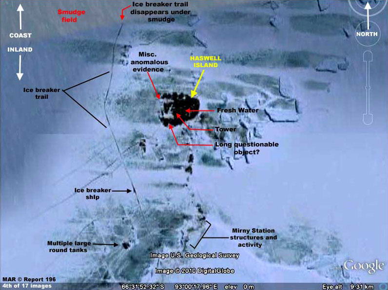
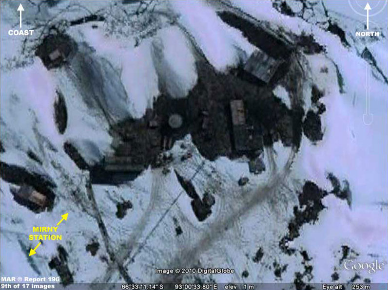
The above 3rd and 4th still distant view images zero in on the general evidence site closer with the 4th image identifying the evidence scattered over a wide area.
Now remember that some of the
visual evidence is just of Mirny Station with nothing especially
anomalous about it. I've included this kind of evidence here so that
you know that the evidence I will point out as being anomalous is
not to be confused with the not particularly anomalous Mirny Station
evidence and where the anomalous evidence is located relative to
Mirny Station.
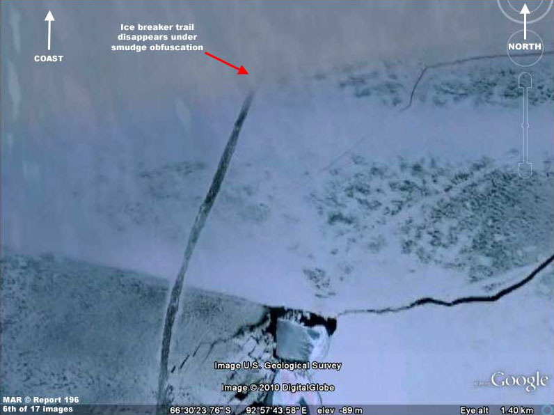
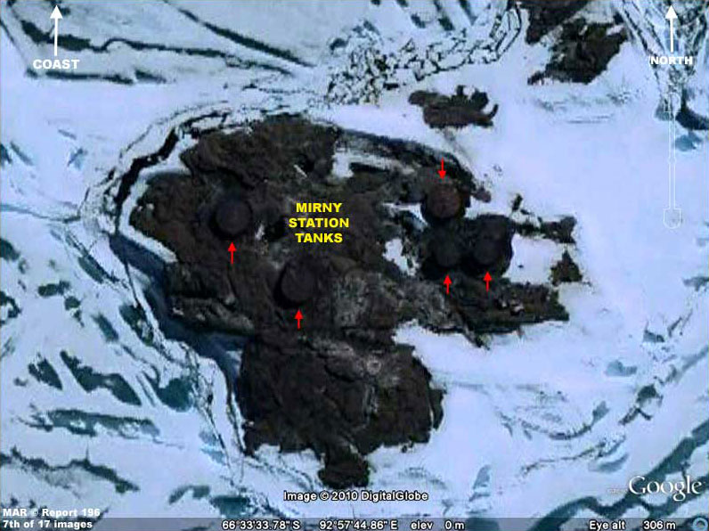
There is nothing particularly anomalous about it until it gets to the very top of the image where the trail doesn't stop so much as it disappears underneath a heavy application of dense smudge image tampering at the coast. Note that near the bottom of the image and to the left of the ice breaker trail is a rocky island with multiple old round likely fuel tanks isolated on it.
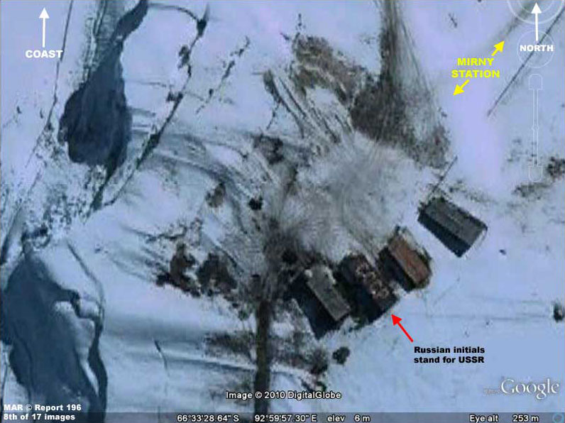
On the lower right of the ice breaker trail is the Mirny Station sites complete with structures dating back to the days of the USSR as well as signs of ground activity.
Note that they are located inland bypassing Haswell Island which is between the Davis Sea coast and the station.
You be the judge as the evidence unfolds below here in this report.
Be forewarned that most of this anomalous
evidence is compromised by poor visual quality due to being at the
limit of resolution as well as a lot of image tampering treatments.
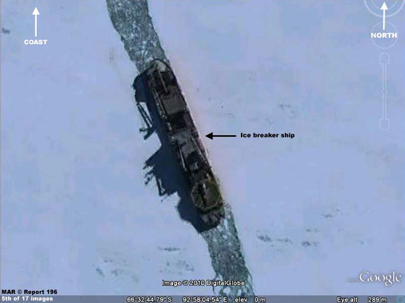
As you can see in the above 5th and 6th images, an ice breaker ship has created a trail or path through the ice field from the coast to a point inland just beyond Haswell Island.
The ship appears to have
turned around and is now exiting back down its own trail toward the
coast which area is hidden under smudge treatments.
What is it there at the coastal area that someone doesn't wish
us to see?
The above 7th, 8th and 9th images are all associated with the Mirny Station facilities dating back as much as 54 years and are not particularly anomalous.
As you can see, the 7th image is of the tank site and the 8th and 9th images demonstrate a collection of Mirny Stations structures scattered in the ice and rocks around in the terrain.
Some likely date back to 1946 when the station was first established and in later years. Most of the tanks for example look very old.
This kind of evidence is included here to demonstrate what
the Mirny Station area looks like, where it is located, and why it
should not be confused with the more anomalous evidence located at
the Haswell Island sites as follows.
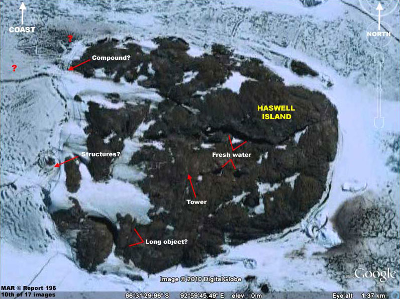
The above 10th image of Haswell Island serves as the locator image for the more anomalous evidence in this report.
There is plenty of anomalous evidence at this site but most of it is so image resolution and smudge image tampering compromised that not much can be made of it with any real confidence and so I've skipped over that.
The samplings that I have pointed out here suffer from this
problem as well but a little less compromised and I suspect some of
you will find them suggestive and interesting.
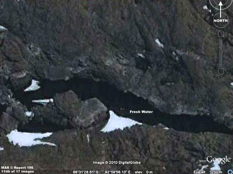
The above 11th image demonstrates a fairly large long ribbon of green tinted fresh water in the Haswell Island rocky terrain.
Note that it, like the many water sites reported on in my last Report 195, is in an impossible liquid state in this extremely freezing cold and windy terrain of the coastal area of the Antarctic continent, the coldest place on Earth.
There are also two fairly
large lakes below this point and near the site of the tower or spire
shaped object.
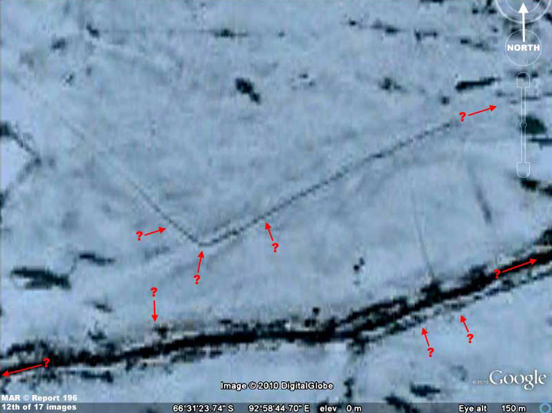
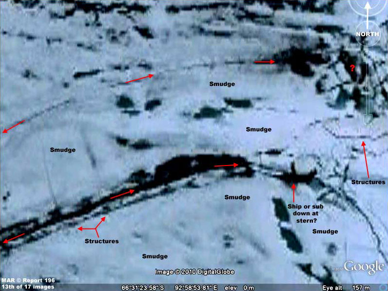
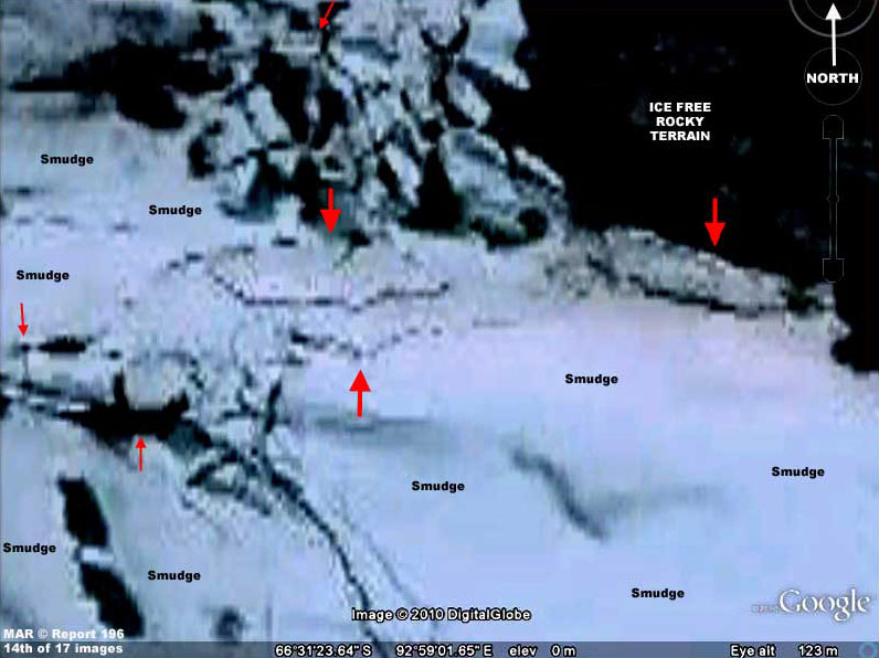
As you can see, the above 12th, 13th, and 14th images, each panning from left to right in sequence demonstrate a lot of evidence that suggests civilization even though it is at the limit of visual resolution and has been compromised by a lot of smudge treatments.
The presence of all that extensive smudge suggests to me that an
extensive amount of larger more recognizable objects have likely
been hidden from our view leaving only the smaller evidence for us
to see a bit of.
Avoiding this more favorable site just doesn't make sense to me. It logically suggests that this Haswell Island locale is being intentionally avoided.
If so, the obvious question is why?
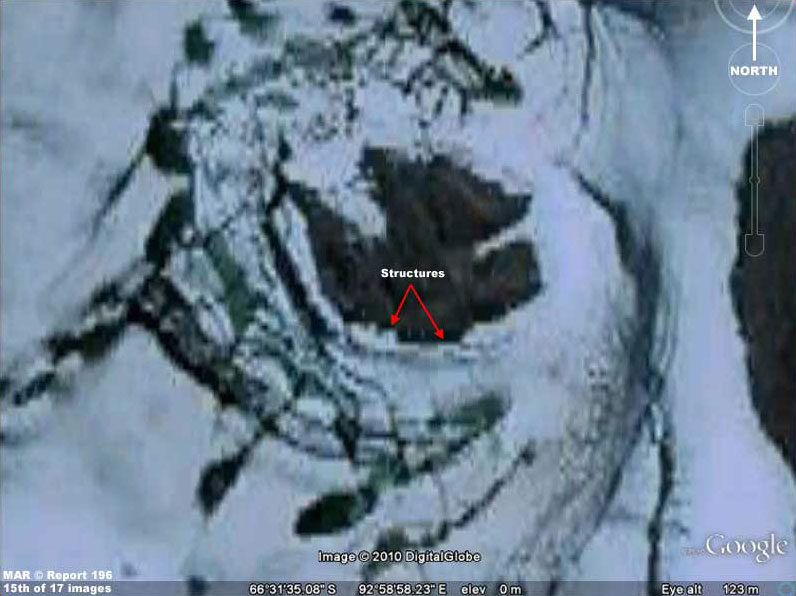
The above 15th image is another one demonstrating a smaller group of likely geometric shaped structures.
Some will argue that these shapes are caused by imaging and/or processing artifacts and that this is the same with the previous 12th, 13th, and 14th image evidence. Without getting into technical discussions, this isn't image artifacts but this observation is based on experience and others wishing to avoid the truth will still want to have their way.
So let them think whatever they will.
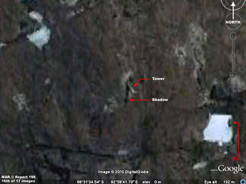
The above 16th image primarily demonstrates a close in shot of a tall tower in the terrain casting a lengthy dark shadow.
I got as
close as I could with this piece of evidence because I want you to
also take a careful look at the brown tinted fluffy texture look
that is characteristic of a lot of the rocky terrain. I suspect this
brownish fluffy look to be carefully applied smudge image tampering.
I suspect that the small lighter color area around the base of the
tower and at other small spots to be the real terrain color.
If you
will look close, even though this is suppose to be raw rocky terrain
devoid of any tree growth obscuring it, the brownish areas a
actually devoid of any real texture except for some lighter and
darker shadings that only mimic rocky irregularities.
The only dark areas are either water or dark places that are
highly suspicious as tampering applications or crack and crevassing
dark interiors.
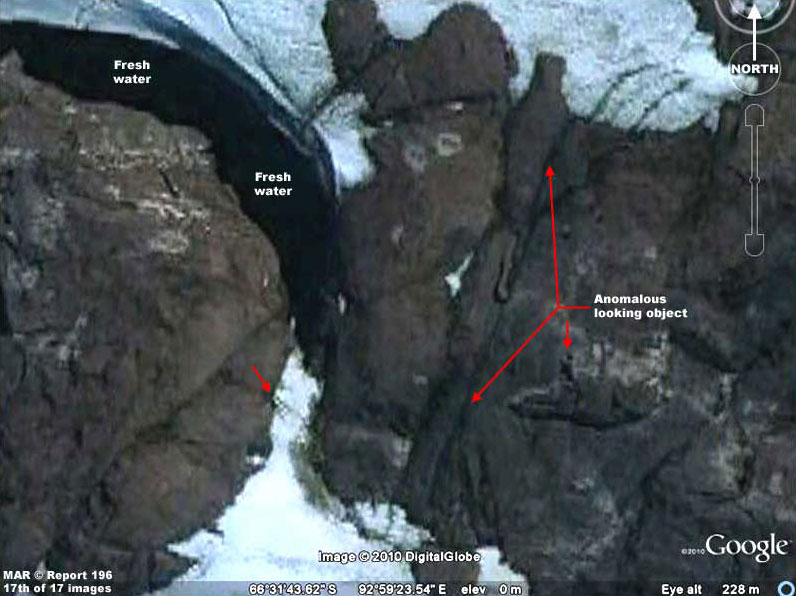
The above 17th and last image demonstrates a long continuous object of unknown origin or makeup.
It is colored like the rocks that surround it and may be just more rock?
However, more than likely its visual surface texture and color is a result of careful smudge treatments applied to it as well as to the surrounding rocks causing it to blend in with those surfaces. However, that long continuous cylinder shape looks suspiciously anomalous to me with its long slender but massive uniformity. It reminds me of a long cylinder shaped object falling from the sky wedging into this site and becoming a permanent fixture in it.
Could it be some strange ancient
ship?
In my opinion, it is a matter of truthfulness and the lack
of it coming from the most influential parties on this planet. How
are we populations ever to advance when information pathways to us
are filled with worthless tripe, false information, and lies?
I suspect the main publicly known expedition involved in this was the 1946-47 military recon in force to Antarctica named Operation Highjump.
I suspect that this
civilization evidence is regarded as a potential resource for
gaining advanced technological advantage and therefore kept secret
from a public that might object to our trying to raid this resource
and/or might want to freak out if it is alien and they knew of that
with certainty.
I have no crystal ball insight into that but I suspect it is logically part of a program by others to allow our kind an arms length proximity drawn by the bait like flies to honey of technological gain that eventually generates familiarity and a gradual reduction of fear driven aggression reaction on our kind's part.
Of course I could
also just be full of it on this to. Certainly that would be the
official take and those that do not want to be disturbed reaction to
such comments, but then there is all that extensive smudge to
explain away too.
We may find that we have behaved in our assumptions like the preverbal Ostrich with its head buried in the sand pretending that it is safe and believing in what we want to believe.
Could it be that someone
who is not us has an older and better claim to parts of this world?
As just one lone example, cancer is a great killer of humans and the battle against it consumes billions of people's lives world wide and their wealth which at the same time also enriches great world industries. A cheap and readily available cure would benefit populations in the billions immensely but also destroy the great industries that parasite off of this terrible scourge. It's the same with energy and its consumption.
Note that the most
influential people in the world are also the richest. How do you
think that came about?
Why? Because the suffering of the many benefits the few in
mega ways important to them and it is how they got to be the richest
and most influential by acquiring and keeping advantage under wraps
and blocking it from common public knowledge.
Meanwhile, I
suspect others watch to see if we can break these chains of our own
making but worse, they are likely judging our fitness to fit in
their greater environments. Report 197
ANTARCTICA MYSTERIES 3
The above 1st and 2nd images are locator images that should assist you a bit in locating and verifying this evidence site behind me in Google Earth.
A point of this reporting is to provide yet more verifiable evidence that the great bulk of Antarctica imaging is very purposefully manipulated and obfuscated and it is not only to hide some kind of truth from the public but also to misdirect public attention down comfortable but false paths.
You should be concerned
about this because the massive extensiveness of the obfuscation
involving an entire continent of millions of square miles is a
direct measure of the magnitude of this deception and how someone
controlling this has so little regard for you and I and our
intelligence.
The only parties that this
information has been successfully hidden from is the public via
obfuscation of media that is primarily accessible by the public. You
should be concerned about that simply because it is slippery
business of the worst kind and just plain wrong.
Remember this, such an expenditure of time, effort, and money would
not be spent unless someone anticipated the public being a source of
trouble if they knew about it.
I suspect such a massive level of obfuscation is to keep
the world public dumbed down in ignorance and misdirected into
shallow behavior so that we will not become aware, upset, and start
trying to interfere with the personal plans and goals of others who
likely care little for our public welfare beyond the need to
preserve us primarily to serve their ability to parasite off of us.
Also, it is what former President Eisenhower clearly felt compelled
to at least publicly warned us about with respect to the collusion
of the military/industrial complex
as he was leaving the Presidency
and even though he was a military man of the highest order.
If this sounds pathetic to some, that's because quite frankly it is.
Yes our trust in others has been betrayed but we are
also complicit because we have betrayed ourselves via our
willingness to go along with this state of affairs without
sufficient questioning resulting in our failing to cast off the
binding chains of ignorance.
This evidence does have great importance in at least its
potential implications. You will of course have to decide any degree
of merit of this conclusion for yourself.
Well done
Marc and I'm more than happy to share credit with you.
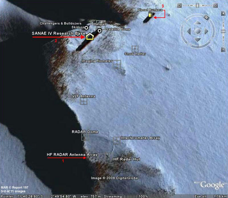
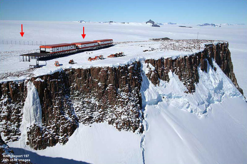
http://www.doctorross.co.za/sanae-on-google-earth The above 3rd image shows through aircraft oblique angle publicity photos just what someone wants us see.
What they want us to see is that this is just an technologically updated South African formally Norway Antarctic research station known as Sanae IV. Innocent enough looking in the publicity shots isn't it. Note the three red arrows pointing to #1 a HF Radar antenna array, #2 the main station buildings, and #3 what is identified officially as diesel fuel bunkers.
Now below in the 4th and 5th images you will see some publicity photos of parts of Sanae IV station.
Note that they show
closer views but actually carefully still only limited views of the
evidence in question at this site.
http://www.doctorross.co.za/sanae-iv-physical-environment The above 4th image is an oblique angle aerial photo of the Sanae IV station elevated main building structures as pointed out by the red arrow on the right.
The clear open elevated platform on the left end of the buildings chain is suppose to be a helicopter pad. In the background on the left pointed out by another red arrow is a line of poles with cross members at the top that is officially labeled as forming an HF Radar antenna array.
As for the geology of the place,
look closely at the dark parts of the cliff face free of snow and
you will see that it consists of many vertical oriented rock
formations almost tubular in shape.
http://www.doctorross.co.za/wpg2?g2_itemId=1007
The above 5th image is again another publicity photo.
It gives us a much closer look at the main station buildings of modular design elevated up on metal stilts with wide metal tie down straps to keep these structures from eventually being buried under seasonal snow fall and/or being blown away by strong polar winds that might be consistent with an elevated bluff like this in a cold polar environment.
Note that in this image the top and bottom corner edges
of the main station buildings are of red material with the metal
supports and straps dividing the material into chains of equal
sections.
Let's see if or how this was
accomplished.
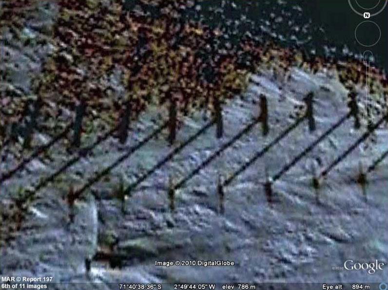
The above 6th image depicts a portion of the HF Radar antenna array system closer in Google Earth.
If this evidence looks strange here, it's because most of it appears to be actually covered over by image tampering to prevent revealing details by very careful object specific applications of dark smudge treatments that have altered its looks. In other words, it's okay for the you and I in the public to see this evidence at a distance in aerial photos but not closer where better details can be discerned.
Why is this obfuscation of a
few pole details present at all must less directed at just you and I
in the public?
They can theoretically see this evidence far far better than
we can here in these poor Google images. Why then is it so important
to obscure this evidence from you and I in the public?
What ever is being hidden over millions of square miles on an entire continent as exampled by this kind of obfuscation evidence here is being hidden primarily from the public, not from competitors or enemies. That means hidden from you and I.
What threat could the public be that would necessitate such
careful object specific obfuscation?
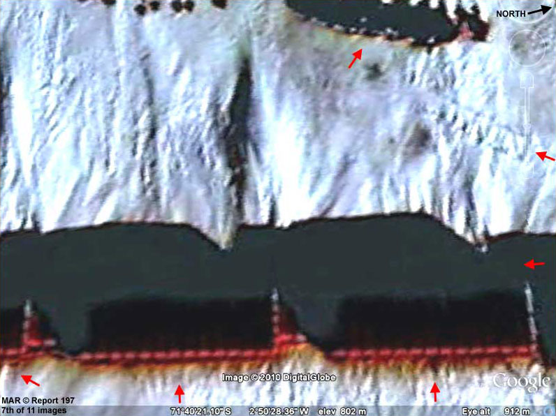
In the above 7th image, we see the location of the Sanae IV station main buildings in Google, you know the ones on elevated metal stilts.
It is assumed that the equally spaced red lights are likely heat sources within and behind the red top and bottom corner edge material of the buildings seen in the closer view of image #5.
But,
if you will look closer and more carefully above, you'll see that
the bulk of the buildings are now thoroughly hidden behind carefully
applied obfuscating blot out dark smudge treatments specific to just
these structures.
Again, remember that this
obfuscation tactical works primarily against the public in public
media and not against competitors or enemies that have access to
their own satellite images without any obfuscation.
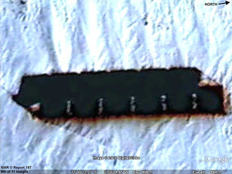
The above 8th image is what is suppose to be ordinary diesel fuel storage bunkers as officially labeled.
Yet note the same kind of careful object specific dark smudge image tampering completely hiding what this kind of evidence is officially suppose to be according to distant views and official labeling.
Remember, almost the whole of the Antarctica continent is obfuscated from public view and even tiny bits of it that are not are still obfuscated by less easy to detect object specific image tampering such as that above in this report.
That's way too much effort and expense just to be doing it for a lark.
Obviously the many millions
spent on this clearly demonstrates that someone is very serious
about this secrecy and therefore we should be as well, especially
since we in the public are almost certainly paying for all of this.
The above 9th image is of a strip of terrain at the Sanae IV station located just off the diesel fuel bunkers partly visible as the large dark spot at the bottom edge of this image stretching up to a point near the Sanae IV main buildings.
It has a lot of smudge image tampering partially obscuring it but note the round large disc imprints in this terrain.
Since there is a hard metal base elevated helicopter pad available for use at the end of the main building structures as officially labeled,
Take you pick.
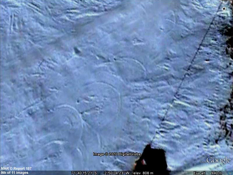
The above 10th image is one taken very nearby Norway's Troll Research Station.
When Sanae IV was turned over to the South
Africans, Norway concentrated more on Troll Station and it is only
about 103 miles or 165 km east from Sanae IV station. The distance
between the two stations is relatively trivial compared to the 5.4
million square miles that the entire continent occupies. Both
stations are by the way within the sector of the continent claimed
by Norway.
Such
brown areas more or less free of snow and ice are almost always
irregular shaped areas. However, the regular clump like formations
over such a wide area in the above 11th image suggests that
something else is going on here near Troll station
Why? Because the ice would form in the woody more
moist areas and the ice crystals would shatter the growth from the
inside out. On the other hand, remember those unfrozen fresh water
lakes I introduced to you in my Report #195 on Bunger Hills and
their implications.
Even so, when a search is made for publicity photos of the outer terrain around Troll Station, it is always bitter wind swept cold snow and ice with some small rocks but never the large brown clump systems you see above. Why? After all the regularity of this evidence would clearly provoke curiosity and imaging.
Obviously something is quite wrong with these
very different visual depictions.
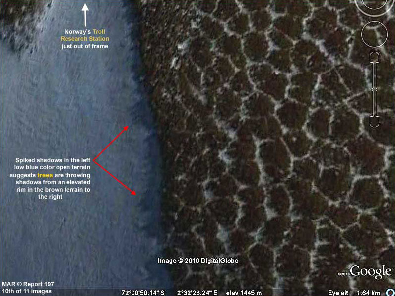
The above 11th image that I call "hole in the tampering" or "the egg that shouldn't be" returns us full circle on the obfuscation presence evidence.
Then there is the above 11th image example demonstrating a hole through the normally always present thick layers of blur and smudge image tampering revealing the sharp contrast of the very rugged terrain below that is so typical of the type of universal obfuscation all over the continent.
Frankly, I'm warning you that
you need to be concerned about this and what it may be hiding.
Evidence that wide spread and massive just cannot be explained
for example by some
rumored German military presence begun at some
point since the turn of the last century. There just isn't enough
time for it and there is simply no reason for the expenditure of
such a mega effort to hide simply rock, soil, and water geology.
Where there is smoke and a lot of it, there is usually fire and a lot of it.
The
extensiveness of the image tampering is like the smoke and what else
but advanced intelligence presence that cannot be defeated or
suppressed in secret would be important enough for Earth humans to
try to pretend to deal with in this wrong headed way?
If such a people are present right here on Earth that
are not us, I repeat, what must they think of us?
A truly advanced culture may find
this Earth public condition just as appalling as dealing with those
leaders corrupted by power.
What does that say about who
has the power and who does not?
Also, remember that
although it might be difficult for the public to get truthful
information from distant places like the Moon and Mars not tainted
by black project manipulation, such information can be more
obtainable and quicker from older technology fly over camera survey
work over Antarctica circumventing the black project control and
without the investment in fabulous scientific expertise.
The big question is what is
it as confirmed by visual evidence imaging of our own.
Perhaps some of us can at least
demonstrate to anyone watching that we at least have enough merit as
individuals for consideration.
A balance on this can
be achieved.
For me, the bulk of a whole continent being so thoroughly obfuscated with a doubt at our financial expense is just absolutely not acceptable if some of our own people are doing it. It is holding us all back and consigning us to someone else's dung heap. No one is going to break the servitude chains for us including any of those potentially represented by the evidence here.
This is
something that we must do for ourselves to prove that we deserve
something more.
|