|
from MarsAnomalyResearch Website
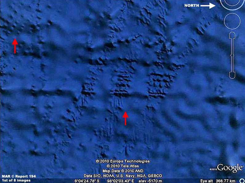
The above 1st image is included here not really to demonstrate anomalous submerged evidence in oceans as it is to demonstrate that what you will see in the evidence further down in this report is very likely influenced and compromised to some extent by official level obfuscation tactics in the Google Earth imaging.
The above scene is an example located off the west
coast of the islands of Malaysia and east of West Island in the
Indian Ocean and in an area of fracture zones in the sea bed.
A sign that the smooth is smudge
is the sharp spot like transition from the rough patches to the
smooth and vice versa.
Most of the evidence sites we'll see in Google Earth and in this report have been treated in this way meant to mimic natural filling in and covering over of rough textured evidence with this smoothed smudge and one cannot conclusively tell how much is due to natural silting from ancient times to the present and how much is due to modern smudge treatments.
For example, these
treatments have been very effective in obscuring the rough terrain
in the above image and only selective spot placement of the smudge
gives one pause to suspect these areas of in fact subjected to
smudge.
The rigid
organized patterns of the evidence is typical of artificial origins
and likely implemented by intelligence and advanced technology back
in ancient times likely before our civilization's climb. In other
words, I want you to learn to take the obfuscation tactics into
consideration when you're viewing evidence like this and never
forget its presence and influence.
So, when we're looking at this evidence, we're likely looking at only a very small percentage of what is really down there, and most of us would likely be really shocked if we could see all of the smaller context evidence without the obfuscation presence.
In any case, let's get on with this reports evidence below.
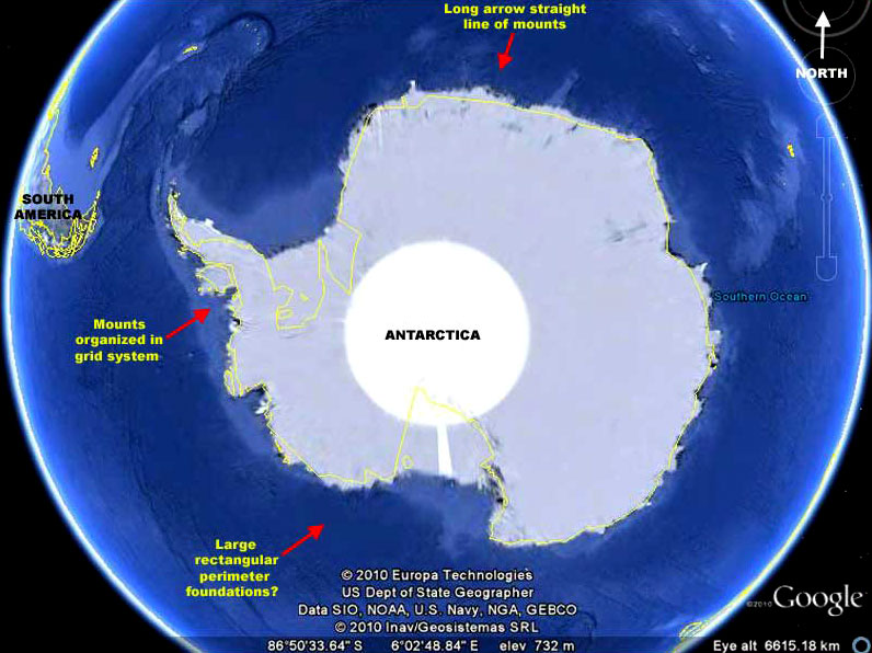
The above 2nd image demonstrates the location of the below next three evidence sites just off the coast of the ice covered Antarctica continent.
Note that all three are not too far offshore but remember that offshore off of Antarctica in these times means offshore of the great ice masses and sheets that surround this continent and extend offshore.
So this evidence may have been
created in ancient times before this civilization when this
continent was not covered by ice and the current ice presence may be
naturally obscuring other important evidence at these sites in the
imaging.
However, the obfuscation doesn't stop there,
it's just the most obvious.
Needless to say, it is very suspicious when most of an entire large continent is treated in this way and should logically give an objective person pause.
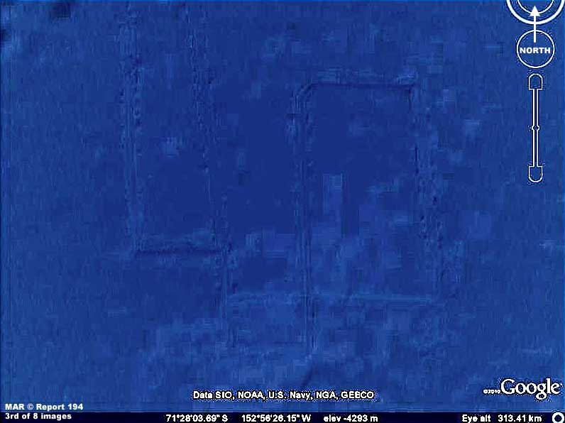
The above 3rd dim image evidence shows what appears to be rigidly straight linear lines both parallel and at 90º right angles to each other forming clear rectangles that interconnect and share sides.
This evidence is offshore of the southern Pacific Ocean side of the
Antarctica continent in a large area of what appears to me to be
obscuring opaque smudge. So it is not easy to find or really get a
good look at it. I already had this but it was then brought to my
attention by a Frenchman with the handle arbona and a nice piece of
work too I might add.
So this evidence may be in part compromised by fissure systems some distance away but that rigid very organized system of arrow straight line forming rectangles is still hard to explain by fissures alone.
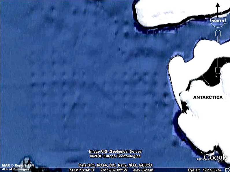
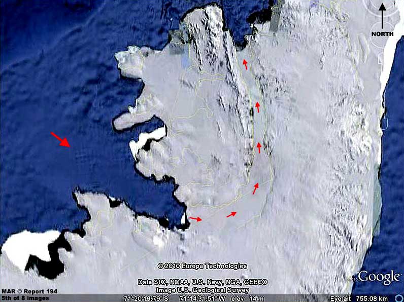
The above 4th and 5th image evidence is located right off the coast of Antarctica and on a substantial peninsula like arm of Antarctica extending up forming the southern boundary of the Cape Horn passage between South America and Antarctica.
What we are looking at is a
rigidly organized grid like pattern of a large group of ocean floor
mounts sticking above the seabed and printing through a large area
of obscuring smudge treatment. Again, I already had this evidence
but it was also subsequently pointed out to me recently in some nice
work by Dr. Courtney Brown with the Farsight Institute of
Remote
Viewing fame.
These mounts may have been the pier like
underwater foundations of some structures but more likely they are a
breakwater to protect the mouth of this inlet as a harbor or they
are underwater military obstructions.
I've done this to bring to your attention that all is not what it may at first appear to be when the eye moves inland in this Antarctica scene so covered over with obscuring bright white reflective surfaces. These arrows are actually located in a huge wide water passage that goes inland, swings in a left curve up north, and continuing many miles north cutting through a mountain range in an arc to the left and back into the ocean at the Rhyolite Islands group.
This passage cuts
a very large mountainous landmass off from the main Antarctica
continent forming a huge island or more specifically a group of
rugged islands.
Remember, these natural white surface
conditions washing out finer detail are also graphically very easy
to mimic with smudge treatments and, in my opinion, that has been
done here extensively creating a continuous landmass illusion unless
one goes to the trouble of looking closer.
Although its distant appearance from above in Google Earth may look like the passage is filled solid with an ice glacier, if this passage is fjord deep in between the surrounding mountains, it may even still be navigable and used by submarines deep under the current ice cover.
Remember,
in the manipulated Google Earth visuals we cannot assume that any
natural ice cover is really complete considering that some of that
inland reflective white cover may be the result of smudge treatments
and not real.
Be reminded that shortly after WWII an "expeditionary" military force (an entire fleet including an aircraft carrier) of ships and thousands of men was definitely sent to Antarctica for "exploration" purposes.
Of course such a large military force commitment suggests a covert secret mission cranking up the rumor and denial mills. Further, although this is officially denied, it has been rumored that two atomic blasts were set off some where at or near Antarctica back in those post WWII times.
In fact,
although I didn't understand the significance of this at the time
some years ago and didn't preserve it, I've seen pictures that
included a fleet of ships in the foreground, a completely snow and
ice covered landmass and mountain range in the far background, and
an unmistakable atomic blast between the ships and the landmass. The
presence of a high mountain range suggested Antarctica.
Could it be that those few freezing Nazis had discovered and had
access to technology in isolated Antarctica carried over from an
older civilization? If so, a technology resource like that would
have warranted an expedition "in force."
Remember, the passage being open at both ends
to the sea in warmer temperature conditions could have resulted in a
maelstrom of rough tidal currents and flows that likely needed to be
tamed.
Could it be that we are looking at a small amount of visible evidence of a military submarine facility hidden away in the inland mountains accessible under the ice via this underwater passage?
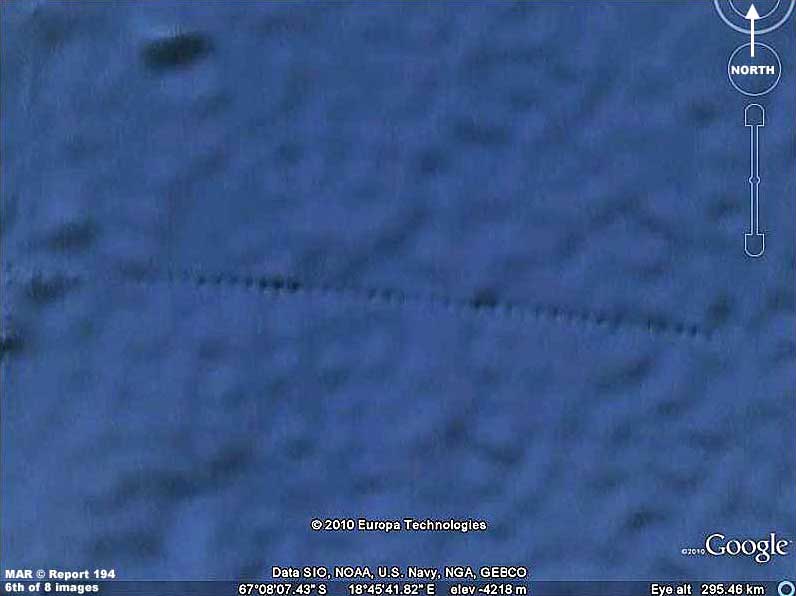
The above 6th image evidence is a single long straight line of what appear to be underwater mounts off the Atlantic Ocean coast side of Antarctica.
This evidence is just one of several in this general
area but this is the longest, most pronounced, and the best visible
example. All of the others are a little closer inshore and also all
are generally parallel to the present Antarctica shore line. Note
the mount's single straight line closer equal placement one relative
to the to other which again suggests a breakwater design.
Remember, this is not offshore of some human heavily populated region of the world that might have the will and resources for such a large undertaking but offshore of hard frozen Antarctica theoretically populated by seals, penguins, and a few human remote research stations and differing country claim agreements that would likely preclude such large scale operations.
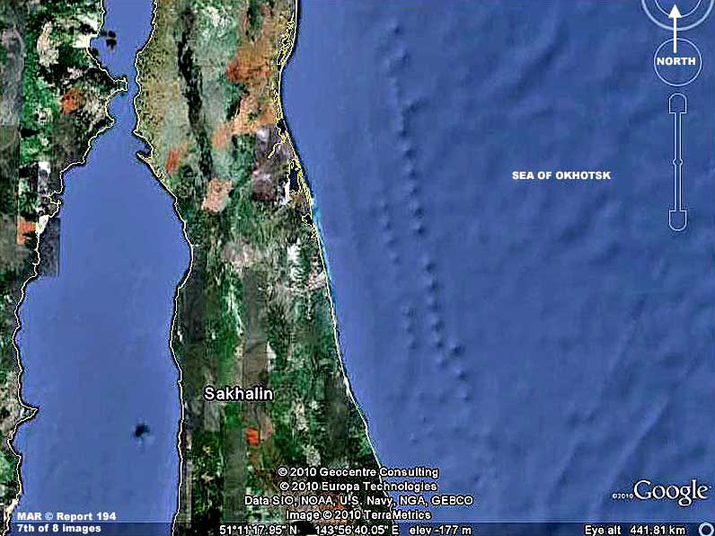
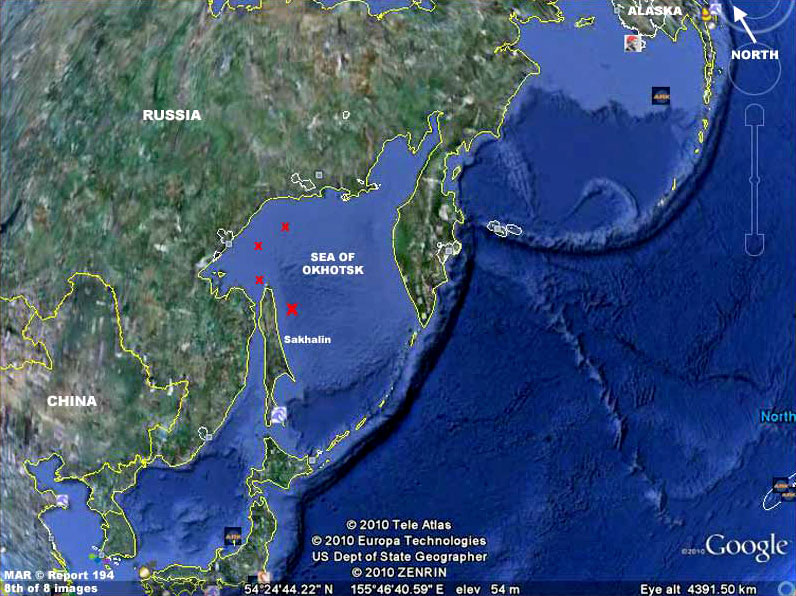
It's the same with the above 7th and 8th image evidence in the Sea of Okhotsk off the northeast coast of Russia.
It's another line of
underwater mounts offshore of a large island as seen in the 7th
image as represented by the larger red "X" in the above 8th context
image. There are also other lines of mounts evidence off the Russian
shore in the same Sea of Okhotsk as well as a grid system off of the
north tip of the island and all represented by smaller red "X's" in
the above 8th context image for those interesting in looking them up
in Google Earth behind me.
For the most part, the only reason that we can get a look at this little bit of evidence is in the mistakes made in the obfuscation of the imaging insufficiently anticipating that you and I might regard this as anomalous. The suggestive evidence you see here is always in remote less frequented places and often where freezing temperatures and ice are factors and viewer interest in the locale is generally low.
Even
if one does chance upon such evidence, it it at best regarded as a
curiosity more than anything else unless the viewer really thinks
independently about it as evidence.
Further, it should not be forgotten that we are seeing
this evidence only because of its size and in spite of inadequate
attempts to obscure it and that is evidence too. There is no telling
how much of this type of evidence exists underwater around the
planet that has been successfully obscured and we are just not
seeing it.
Yes there is that psychology but then you must also ask yourself,
Surely that alone via logic and reason is enough clue to tip
one into a questioning mode.
We are left to live in ignorance and denial and root around in their created just for us designer garbage dump of leavings hoping for rare tiny kernels of overlooked truth even as to our own planet and its past.
It is just incredibly poor human behavior!
|