

El Niño and its counterpart, La Niña - which is defined by a cooling of the equatorial Pacific - have powerful knock-on effects around the globe.
This oscillation forms the basis of most seasonal weather predictions, and scientists are mining the data for clues that will improve those predictions.
NOAA has spent roughly US$3 million to deploy aircraft, a research ship and hundreds of weather balloons to capture as much data as possible before the El Niño fades in the next few months.
And the US National Science Foundation (NSF) has awarded 19 'rapid response' research grants, totaling $2.3 million, to researchers studying the event.
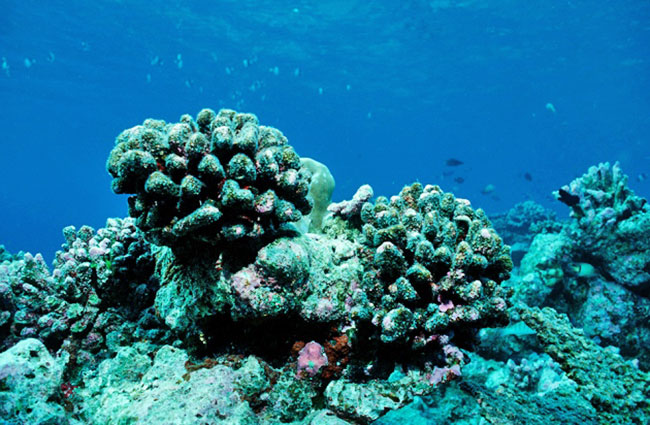
Many of the NSF projects focus on the effects of warm seawater on coral reefs; if water is too hot, corals bleach, expelling the colorful algae that feed them. The current bleaching event began in Guam in 2014 and has since spread to the Atlantic and Indian oceans as El Niño has warmed the seas (see below insert).
More than 60% of the world's corals could be affected in the next few months, and with NOAA predicting that bleaching will continue into 2017, that number could rise.
Selected El Niño impacts
The strong El Niño warming event
...that began last year has affected conditions around the
globe.
|
Eastern Africa |
The failure of spring rains in 2015 affected crops in central Ethiopia and Sudan. Areas further south have been hit by heavy rains and flooding. |
|
South America |
Paraguay was hit by torrential rains this December and January, causing flooding and the evacuation of more than 100,000 people. |
|
Australia |
El Niño has been linked to warm and dry conditions in 2015. |
|
India |
Much of India experienced below-normal rainfall from June to September. There was above-normal rainfall in southern India and Sri Lanka this winter. |
|
Oceania |
Coral reefs in the central Pacific Ocean are on the front line of a global bleaching event that has also affected reefs in the Atlantic and Indian oceans. |
Source: WMO
Scientists and policymakers often focus on the long-term risk posed by carbon dioxide emissions and ocean acidification.
The current bleaching event - already the longest on record - has shone a spotlight on the immediate danger posed by rising ocean temperatures.
"Ocean acidification may be much less of a problem than we feared, but that's only because many of the corals will be dead before we get there," says Mark Eakin, who heads NOAA's Coral Reef Watch.
In other cases, scientists were lucky to be able to watch El Niño unfold.
Daniel Rudnick, an oceanographer at the University of California, San Diego, and his colleagues received grants from the NSF and NOAA in 2012 and 2013 to deploy a trio of underwater gliders in the tropical Pacific from 2013-16.
The team also released 41 new Argo floats - roughly double the previous number - along the Equator to collect temperature and salinity data down to 2,000 meters.
"When you have an event this big, you really want to squeeze as much out of it as you can."
In November 2013, the gliders began to collect high-resolution measurements of the subsurface ocean current's eastward flow.
The monitoring will continue this year.
"It's been shown that the undercurrent strengthens during El Niño, but what we have, I think, is a more finely resolved picture of its size," Rudnick says.
"It was serendipity with a capital 'S'."
Rudnick presented preliminary data on 23 February at an American Geophysical Union conference in New Orleans, Louisiana.
The observations document the under-current's evolution in 2014, when the forecasted El Niño fizzled, and in 2015, when it roared back. By comparing the oceanic and atmospheric conditions in both years, scientists hope to gain insights that will improve future weather forecasts.
The focus is often on the trade winds, which usually blow to the west across the Equator.
Alexey Fedorov, an oceanographer at Yale University in New Haven, Connecticut, says that 2014 and 2015 both saw significant bursts of eastward winds in June, which began to push warm surface waters towards South America.
In 2014, a burst of westward winds in August, driven by atmospheric patterns in the Southern Hemisphere, cut that process short - but helped to set the stage for the massive El Niño in 2015.
Fedorov says that there is no evidence that those winds could have been forecast, even by the most advanced climate models.
"Sometimes we are right, sometimes we are wrong," he says. "There was no chance to predict this."
Although temperatures in the tropical Pacific are near their peak, McPhaden says that El Niño's energy is quickly dissipating below the surface.
"It's very clear that this El Niño is losing its steam," he says.
And that poses another crucial question for oceanographers and climate scientists:
Whether this El Niño will transition into a major La Niña, as happened after the last big El Niño in 1997-98...