|

by Mrinalini Erkenswick Watsa
August 04, 2015
from
Mongabay Website
In the Peruvian Amazon,
a global craving for gold has changed life for local communities.
Gold mining is intensifying in southern Peru.
Researchers mapped mining-related deforestation
along a major river and in a protected reserve.
Gold mining often releases mercury into the environment,
which can be very harmful
for human and ecosystem health.
In the heart of the Peruvian Amazon, a global craving for precious
metals has changed life for local communities.
As prices remain relatively high and it retains its reputation as a
safe investment, the true costs of gold extraction ripple through
the rainforests of Peru, affecting everything from fish to birds of
prey, and even local human residents.
Along the way, trees continue to be felled to make way for mining
rigs and makeshift homes that ultimately feed the world's appetite
for the elemental metal.
More than 30,000 artisanal gold miners are estimated to be active in
just the
Madre de Dios Department of Peru - which is Spanish for
"Mother of God."
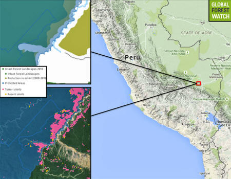
In March of this year, the Monitoring of the Andean Amazon Project (MAAP)
revealed that 1,700 hectares of gold mining-related deforestation
occurred in the La Pampa region of the Madre de Dios Department of
Peru.
Two months later in May,
further evidence shows another 850
hectares of deforestation caused by gold mining in the Upper
Malinowski River, a little west of La Pampa.
These figures were calculated by MAAP's unique approach to
monitoring deforestation - an analysis of satellite imagery with a
specialized software program called CLASLite developed by the
Carnegie Institute for Science.
By comparing satellite imagery of the same location taken at
different periods in time, the MAAP team, consisting of members of
the Amazon Conservation Association, is able to carefully calculate
actual deforestation levels, without ever needing to set foot in the
area itself.
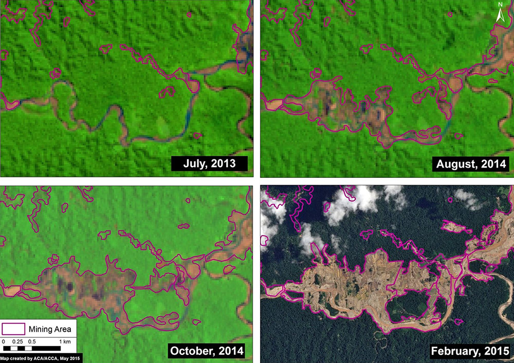
Expanding
deforestation
from illegal gold mining along the Upper Malinowski River.
Key data sources: MINAM, SERNANP, ACCA, USGS, IBC, Hansen/UMD/Google/USGS/NASA.
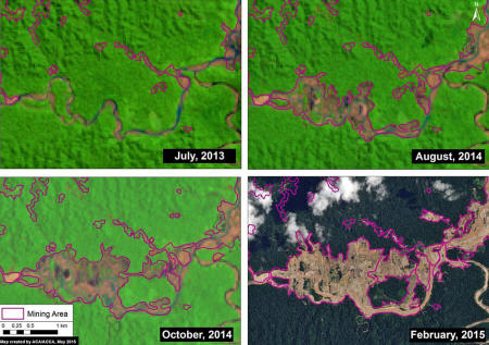
Satellite image time-series (2013 - 2015)
of deforestation along the Upper Malinowski.
Note that all four panels in Image 5d show the same location.
Key data sources: USGS, SPOT 7.
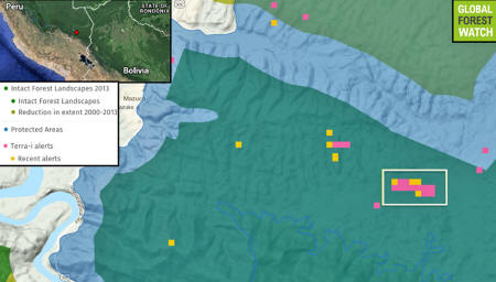
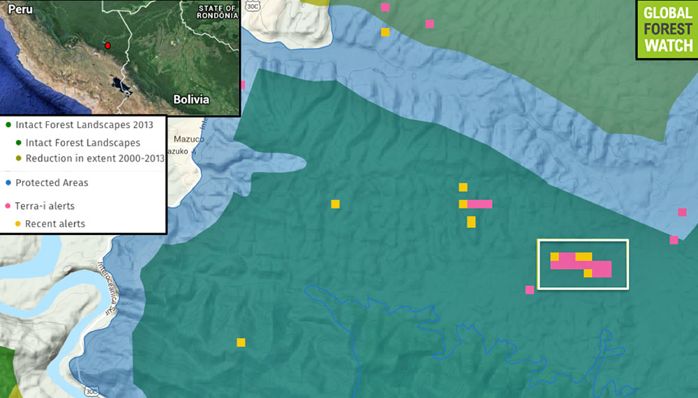
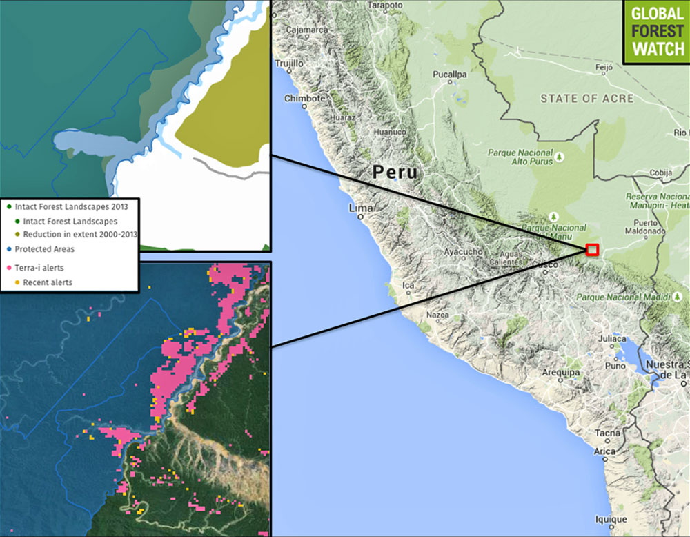
Global Forest Watch data confirms the
region
has lost primary tree cover since 2000.
The inset box shows the area of deforestation along the Upper
Malinowski River,
likely caused by gold mining.
Terra-i data
collected by satellites indicate
11 deforestation alerts have
occurred there since 2009.
The most recent analyses reveal that deforestation is occurring in
an area that is both outside the legally recognized mining corridor
and inside the buffer zone of the
Tambopata National Reserve.
"The Permissible Mining Zone was
established in 2010 and indicates the zone that the Peruvian
Government has delimited as potentially legal for small-scale
and artisanal mining activities, but only if miners successfully
complete a multi-step formalization process for each project,"
report Matt Finer and Sydney Novoa, lead MAAP researchers.
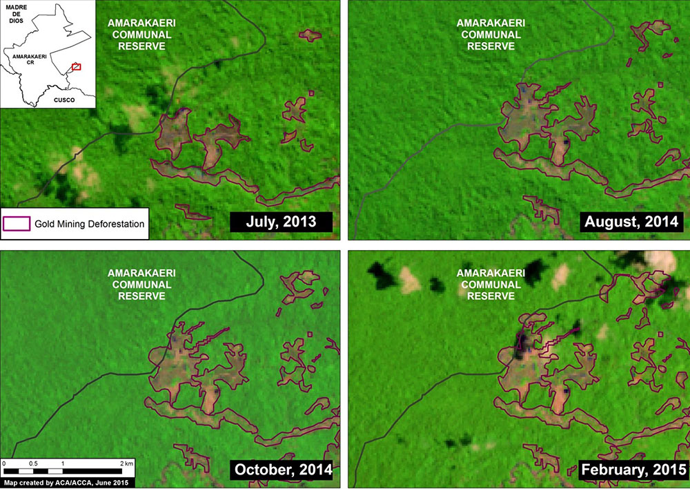
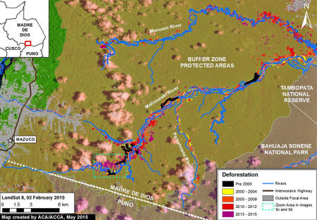
In another part of the Madre de Dios
Department, MAAP
revealed that deforestation in
the mining zone known as Huepetuhe/Delta-1 is now entering the
Amarakaeri Communal Reserve, which is co-managed by indigenous
communities and Peru's National Protected Areas Service.
"Our analysis shows that gold mining
deforestation, expanding from Huepetuhe/Delta-1, entered the
southeast corner of the reserve in 2013 and expanded in 2014 and
2015," report Finer and Novoa.
Even more deforestation can be observed
spreading within the reserve's southeastern buffer zone.
The patterns of deforestation they highlight in satellite images
have been definitively identified as caused by gold mining, with
other potential causes such as agriculture ruled out.
Gold Mining in
Peru
Mining in the Madre de Dios has
transformed the area, with riverbanks displaying evidence of
mining in the hundreds of mounds of gravel that are the primary
remnants of river silt washed clean for gold.
Aerial views leave a stronger impression - 2013 evaluations show
that the mining extent in the region
increased 400 percent from 2000 to 2012.
"According to a pair of technical
reports by the Amazon Conservation Association (ACA) and
Conservaciόn Amazόnica (ACCA), 2,500 hectares has been
deforested in the Tambopata National Reserve buffer zone due to
illegal mining in the past two years," states the ACA's Mining
News Watch in June 2015, a regular compendium of gold mining
related news and data.
Deforestation is not the only negative
side effect of mining in the area.
Gold is often extracted using mercury, with which it forms an
amalgam, making it easier to separate from sediment or ore. But
mercury is highly dangerous when released into the environment, both
via aerial and water-borne dispersal.
In sufficiently high doses it can cause
birth defects and neurological disorders such as
Minamata Disease.
However, that is exactly what must happen to retrieve pure gold -
the mercury is burned off to leave only the gold, causing unbounded
mercury to be released into the water and air.
Recent calculations by the Ministry of the environment
revealed that 40.5 metric tons of mercury enters the Madre de Dios
River annually, which amounts to 5.6 percent of the world's mercury
pollution produced by artisanal mining.
This mercury then enters a range of organisms that live in the
river, eventually accumulating in high levels in animals that occupy
the top rungs of the food chain.
A
study in 2013 in the Journal of Environmental Protection
found that several fish species surveyed in the Tambopata region had
methylmercury levels higher than the U.S. Environmental Protection
Agency fish tissue criterion for human consumption above which
consumption poses a danger to human health, with some samples
showing more than twice the criterion.
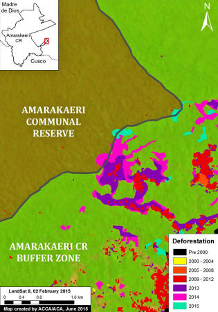
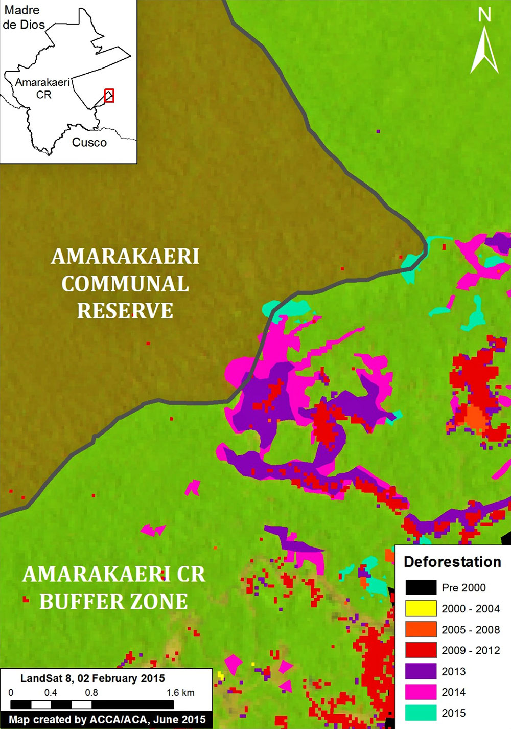
An enhanced
view of the deforestation within the southeast section
of Amarakaeri Communal Reserve and its surrounding buffer zone.
Key data sources: MINAM, SERNANP, ACCA, Hansen/UMD/Google/USGS/NASA,
USGS.

Satellite (Landsat 8) image time-series (2013 - 2015)
of deforestation within the southeast section of the Amarakaeri
Communal Reserve.
Note that all four panels show the same location over time.
Key data sources: USGS, SERNANP.
Terra-i data from
Global Forest Watch show many alerts
have occurred
in the Amarakaeri buffer zone since 2004,
correlating to a large
swath of primary forest
that has been degraded since 2000.
According to the UN Environment Program's
Global Mercury Assessment of 2013, the world's second
largest contributor to mercury pollution is artisanal and
small-scale gold mining (ASGM), conducted by small groups or
families without official government permits, who work a portion of
the year and generally do not officially declare such earnings for
tax purposes.
Attempts by the Peruvian government to regulate such mining
activities have ranged from highly bureaucratic only-on-paper
resolutions to active military efforts to bomb barges on the Madre
de Dios.
Recently, however, a formalization
process was finally created to allow people to acquire mining
permits legally. According to
Mining News
Watch, only 16 permits have been issued to date,
which affect only 1 percent of the 58,835 miners that began the
application process in Puno.
No such permits had been legalized as of
June 10, 2015 in Madre de Dios.
Madre de Dios Regional President Luis Otsuka,
in a meeting, stated
categorically that he would continue to sell gold on the black
market. He drew attention to the glacial pace of the legalization
process, demanding a speedier way to transform undocumented mines
into legal, tax-paying entities.
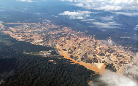
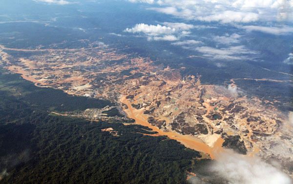
Río Huaypetue gold mine in
Peru.
Photo by Rhett A. Butler
"According
to the Peruvian Financial Intelligence Unit (UIF),
between January and December 2014, illegal mining generated
$2,765 million, surpassing illegal drug trafficking, which
generated $78 million.
The Office for National Electoral
Processes reports that money from both mining and drug
trafficking is making its way into the electoral campaigns of
political organizations," states Mining News Watch.
Meanwhile, the health of local miners
continues to suffer.
Assessments conducted in 2010 of
mercury levels of blood and urine from residents of Huaypetue, an
artisanal gold mining town, revealed that people who heated
gold-mercury amalgams had total urine mercury concentrations nearly
twice as high as those who did not.
In addition, community members
who consumed fish had methylmercury concentrations that were 60
percent higher than nonfish consumers.
Matt
Finer told mongabay.com in an interview that MAAP monitors 30
different areas in Peru, releasing a new set of images on
unmonitored deforestation once a week.
Their goal is to get the
facts verified and published quickly, so that the relevant
authorities may act upon them, thus drawing attention to
deforestation, in real-time, in areas that cannot be easily
monitored from the ground.
Citations
-
Finer M, Novoa S (2015) - Gold
Mining Deforestation Intensifies along Upper Malinowski
(Madre de Dios, Peru) - MAAP:
Image #5.
-
Finer M, Novoa S (2015) - Gold
Mining Deforestation Enters Amarakaeri Communal Reserve
(Madre de Dios, Peru) - MAAP:
Image #6.
-
Fraser, B. (2009) - Peruvian gold
rush threatens health and the environment - Environmental
science & technology, 43(19), 7162-7164.
-
DeRycke E, Finer M (2015).
Peru Mining News Watch Report #16
- Amazon Conservation
Association.
-
Roach, K. A., Jacobsen, N. F.,
Fiorello, C. V., Stronza, A., & Winemiller, K. O. (2013)
- Gold mining and mercury bioaccumulation in a floodplain lake
and main channel of the Tambopata River, Peru.
-
Yard, E. E., Horton, J., Schier,
J. G., Caldwell, K., Sanchez, C., Lewis, L., & Gastaňaga, C.
(2012) - Mercury exposure among artisanal gold miners in
Madre de Dios, Peru: a cross-sectional study - Journal of
Medical Toxicology, 8(4), 441-448.
|