Many 19th-century explorers believed that beyond the belt of pack ice at the perimeter of the Arctic Ocean there was an open polar sea, and possibly continental land as well. The idea of an open polar sea took a long time to dispel, but we now know that there is no iceless ocean beyond 80°N. However, polynyas, temporary areas of ice-free water, occur in both the Arctic Ocean and the Southern Ocean surrounding Antarctica, and are not yet fully understood. Some are 160 km across, and the largest may cover as much as 300,000 sq km, implying a substantial influx of heat [1].
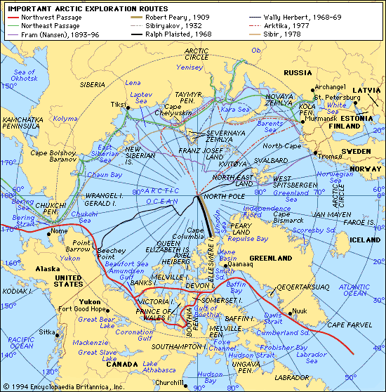
In 1827 an expedition led by Edward Parry ventured far north of Spitzbergen, over ice and along leads of open water. As they sledged north, the ice-field became lighter and more fissured, and they eventually found themselves on the edge of what seemed to be a vast open polar sea, containing only a few scattered pieces of ice. They reached 82°45'N, a record that was unbeaten for half a century. In 1853 Elisha Kent Kane mounted an unsuccessful attempt to reach the north pole via Smith Sound separating Greenland from Ellesmere Island. The same route was attempted in 1861 by Isaac Israel Hayes, who sledged just beyond 80°N. Both expeditions mistook an area of open water for an open polar sea. The first man to reach the edge of the Arctic Ocean was another American, Charles Francis Hall. In 1871 he sailed up the channels leading from Baffin Bay to the Arctic Ocean and reached 82°11'N. Hall died after his ship was hit by a floe.
While attempting to reach the north pole in 1871-73, two young Austrian explorers, Karl Weyprect and Julius Payer, discovered the islands of Franz Joseph Land and came to believe that they were the outliers of a continental landmass. Lieutenant George Washington De Long hoped to find this land. In 1879 he sailed in the Jeanette through the Bering Straits into the Arctic Ocean, planning to take advantage of the warm, north-flowing currents which he believed would open a way through the pack ice. However, in June 1881 his ship sank in the pack ice northeast of the New Siberian Islands, a tragedy which De Long and many of his men did not survive.
Three years after the Jeannette had sunk, debris and scraps of clothing that had littered the floe near the grave of the ship were found embedded in the ice that had been washed ashore in southwest Greenland. This gave the Norwegian polar explorer Fridtjof Nansen the idea for the epic drift of the Fram across the Arctic Ocean, from June 1893 to August 1896. The plan was to drive his specially designed ship into the pack ice in the vicinity of the New Siberian Islands and drift with the currents across the Arctic Ocean towards the Greenland Sea. The Fram drifted across the Polar Basin, but as time went on it became clear that it would not drift over the pole but would bypass it. Nansen and Johansen left the ship to make a dash for the pole across the ice floes with sledges and dogs. They left the Fram in latitude 84°N in March 1895. In just under a month they reached their farthest north of 86°13', from where the northern prospect was 'a veritable chaos of iceblocks'. They then made their way over treacherous ice to Franz Joseph Land, some 400 miles to the southwest, averaging less than 5 miles a day. Nansen was eventually reunited with the Fram at Tromsö in August 1896.
The famous British explorer Wally Herbert writes:
[Nansen's] expedition, in the teeth of scepticism and discouragement, had drifted with the shifting expanse of polar ice across an unknown ocean -- a courageous voyage inspired and conducted with consummate intelligence -- a saga that will never be surpassed. [2]
The expedition found neither land nor an open polar sea. They frequently encountered large stretches of open water, and the weather conditions together with the wildlife and its direction of travel sometimes made them suspect there might be land in the region of the north pole. However, their final conclusion was that the existence of a considerable expanse of land beyond 86°N was highly unlikely.
Figure. Arctic exploration [3].
Some of Nansen's experiences during his arctic voyage in the Fram, as described in his book Farthest North (1898), have become an integral part of hollow-earth lore. Gardner and Reed and many later writers claim that Nansen travelled a considerable distance into the northern polar opening without realizing it. However, Nansen could not have entered the interior without passing a point on the earth's surface that gave a false impression of 90° latitude -- i.e. of being at the north pole -- and there is no evidence that the Fram ever reached such a point. Gardner makes a lot of the fact that after leaving the ship for the abortive attempt on the pole, Nansen was completely lost for many months. He insinuates that this was because the curvature of the earth was different to what was expected due to the fact that Nansen was on the lip of a polar opening. However, Nansen's difficulty in finding Franz Joseph Land was largely due to the fact that he and Johansen had carelessly let their chronometer watches run down, with the result that all their calculations for longitude were out by several degrees.
The arctic climate appears to have varied markedly during the past 2000 years, partly reflecting global trends. For instance, the climate appears to have been much milder from the 5th to 11th centuries, with less permafrost and sea ice [4]. Historical reports indicate that the winter of 1476-77 in Iceland was extremely mild, supporting Christopher Columbus' disputed claim that he found the ocean there to be relatively ice free at the time. The climate subsequently cooled, but Iceland has also had mild winters in more recent times. Weather reports indicate that between 1800 and 1883 there were 20 winters during which no pack ice came down from the polar ice cap north of Iceland [5]. But none of this requires a belief in warm air and ocean currents emerging from a polar hole!
Commander Robert E. Peary (1856-1920) was obsessed by the ambition to be the first man to reach the north pole. His final attempt on the pole was undertaken at the age of 53, after 23 years of arctic exploration (on one of his expeditions he had to have seven of his toes amputated due to frostbite). He set out from Cape Columbia on the north coast of Ellesmere Island on 22 February 1909, and claimed to have reached the north pole on 6 April 1909. However, just before Peary's return to the United States in September 1909, Dr Frederick A. Cook (1865-1940), a respected American explorer who had been with Peary in Greenland in 1891-92 and who had spent 1907-09 in the Arctic, announced that he had reached the pole the year before with two Eskimos, from the north point of Axel Heiberg Island. The Encyclopaedia Britannica comments:
The matter aroused considerable controversy, which is still very much alive. There are grounds for serious doubts as to whether either man reached the pole, since neither was able to produce conclusive evidence to support his claim.[1]
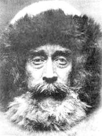
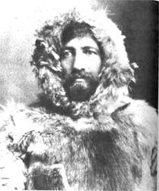
Richard E. Peary. Frederick A. Cook.
The problems with Peary's claim are his very high sledging speeds and his very slack navigation. Peary covered the final leg of 130 nautical miles (nmi) in five marches of 26 nmi each on his outward journey, and in three marches of 43.5 nmi each on his return journey. Peary supporters try to show that these incredible speeds are not impossible by pointing to the successful 1986 polar expedition led by Will Steger. Steger achieved an average speed of 21.7 nmi per day, and even managed 32 nmi in half a day [2]. However, when Steger reached the pole on 1 May 1986, he had few rations, having abandoned most of them to lighten his load, and was airlifted out. He could not have returned to his starting point on what remained, whereas Peary had to carry everything he needed for his round trip. No one has ever reached the north pole and returned to their point of departure as fast Peary allegedly did [3]. This fact undermines the claim of some hollow-earthers that Peary's high sledging speeds were due to the anomalous curvature of the earth in the region of the supposed polar opening.
Peary claimed to have followed a 660 km straight line from Cape Columbia along the 70°W meridian to the pole. His last recorded observation of the sun was at a distance of six travelling days or 220 km from the pole. From here he was accompanied solely by the black explorer Matthew Henson (his manservant) and four Eskimos. He claimed to have travelled the last distance at a faster pace than at any time previously and to have done so without any navigational aids other than 'dead reckoning', which means maintaining your direction forward by observing your track behind. The problem is that the arctic ice is always shifting and moving with the wind and currents. Wally Herbert asks: 'What then gave him the crazy idea that he could strike out across the drifting pack ice, and without any observations for longitude or any checks on the variation of the compass, could aim for and hit the Pole?' [4].
Peary asserted that he had observed the sun from the pole to establish his position, but the observations were not recorded in his diary but on a piece of paper inserted into the diary at that place. Herbert believes Peary probably got little further than 89°. The pages of Peary's diary for 6 April (when he claimed to have reached the pole) and the succeeding two days, are uncharacteristically blank. Herbert believes Peary was then wrestling with a major dilemma. He had to choose 'between admitting that he had gone in the wrong direction and had failed to reach his goal, or looking back along the trail at all those years of suffering and convincing himself that he had earned the right to claim it' [5].
Frederick A. Cook claimed to have reached the north pole on 21 April 1908. He left the last Eskimo village in Greenland in February 1907, and for his assault on the pole he was accompanied by just two Eskimos, Etukishuk and Ahwelah. He stated that on his return journey he had drifted off course and was prevented from reaching his food caches on the mainland. He was forced to spend a winter in the Canadian Arctic, before undertaking a circuitous and difficult sledge journey back to Greenland.
Cook's claim to have been the first man to reach the pole was immediately challenged by Peary but initially won wide acceptance. However, the Peary Arctic Club launched a vigorous campaign to discredit him. They published an article based on interviews with Etukishuk and Ahwelah conducted by several of Peary's men, including Henson and Donald MacMillan. The Eskimos were quoted as saying that they had never ventured far into the polar ocean, and had camped out on the polar ice for several days before returning to land. Cook's claim to have been the first man to reach the summit of Mt McKinley, the highest mountain in North America (20,320 ft/6194 m), in 1906 also came under attack. Ed Barrill, the man who had accompanied Cook to the top, now confessed that they had never been anywhere near the summit, and that the supposed photograph of the summit published in Cook's book had been taken far lower down.
Far more damage was done to Cook's reputation, however, when a committee at the University of Copenhagen, to which Cook had submitted some of his original field notes, ruled that they were not sufficient to prove that he had reached the north pole. The American press proceeded to denounce Cook as 'one of the most monumental impostors of history'. Meanwhile, a committee of the National Geographic Society, composed entirely of Peary's admirers, had endorsed Peary's claim to have discovered the north pole. However, not everybody was satisfied. In 1911 his proofs were examined by a Congressional subcommittee. Although it endorsed his claims by four votes to three,
Peary's testimony before Congress was full of prevarications, contradictions and incredible lapses of memory on crucial points. It was a disaster for Peary, and it set in motion all the doubts that plague his claim to this day. [6]
One of the subcommittee members denounced him as a 'wilful and deliberate liar' and a 'contemptible little ass'!
After a year of self-imposed exile, Cook proceeded to tour Europe and America in an effort to win back public support. He ridiculed Peary at every opportunity, even calling him a 'leprous blot on the fabric of clean human endeavor'. Although public interest in the controversy eventually died out, heated debate between Cook partisans, Peary partisans, and those who are partisans or detractors of both has continued to this day. Cook's advocates, who include several world-class explorers and geographers, describe him as 'the most defamed man in arctic history'.
Regarding the Mt McKinley controversy, Cook's defenders point out that the Peary Arctic Club is now known to have paid Barrill $5000 for his 'confession', and maintain that Cook's descriptions of features at the highest elevations of the mountain indicate that he must have been there. They concede, however, that most if not all of the photographs in Cook's book To the Top of the Continent (1908) were not in fact taken high on the mountain as the captions declared, but they claim that Cook used them as substitutes because he failed to take good, clear photos at the highest altitudes. It does seem rather implausible, though, that he just happened to have photographed features suitable for 'illustrative purposes' even before the real ascent had begun. Moreover, there are important discrepancies between Cook's original diary of his climb (which he never submitted for examination) and his published accounts, as if his story was still evolving [7].
Regarding the Eskimo testimony against Cook, Cook's defenders point out that about 35 polar Eskimos were interviewed by the Danish explorer Knud Rasmussen in the summer of 1909, before Peary returned from his attempt on the pole, and they testified that Etukishuk and Ahwelah had told them that they had travelled over the pack ice with Cook for weeks and had reached the 'Great Nail' (north pole). A year later, however, Rasmussen retracted his report because the two Eskimos had allegedly told a Danish missionary that they did not in fact go all the way to the pole. Peary's supporters issued conflicting statements regarding the testimony of Etukishuk and Ahwelah. It is quite possible that they had misunderstood or misrepresented what the two Eskimos had said, or that the latter had modified their story in order to pacify Peary. So Cook may have travelled further over the pack ice than Peary's followers claimed. But it is noteworthy that the stories handed down among the Eskimos to this day do not support Cook's claim to have reached the north pole [8].
Cook's description of physical conditions and natural features at the north pole and in the region the Central Arctic Basin through which he sledged is said by his supporters to have been confirmed by later exploration in detail after detail, proving he must have come close to the pole [9]. Sceptics, on the other hand, argue that Cook's description of the pack-ice conditions and the drift of the ice near the pole could have been an informed guess based on what he and other explorers had found less far to the north.
As regards the judgement by the University of Copenhagen, Cook's defenders point out that the records submitted by Cook were indeed incomplete, but that this was because while he was in Greenland he had given the rest to Harry Whitney, who was supposed to bring them with him to the US on Peary's vessel. Peary, however, had ordered Whitney to leave behind anything belonging to Cook. Interestingly, Cook never tried to retrieve his records. Indeed, he stated privately that he had copies of them and that they did not contain anything that would prove his claims, though this was not the impression he gave the University of Copenhagen. He admitted to being very happy with its open verdict. There is strong evidence that Cook's navigational abilities were grossly inadequate. He did not submit any of his observations for latitude and longitude to the Danes, though he did include some observations in his book a few years later. However, they contained errors, which were corrected in subsequent editions [10].
All but one of Cook's original notebooks have since come to light. Robert Bryce argues that a careful study of them reveals why he did not want anybody to see them all. They contain various changes to dates, distances, and latitudes, are inconsistent, and differ on important points from his published accounts of his trip, showing how he gradually improved his story. Cook's speeds are also difficult to credit. He claimed to have travelled the 520 miles from Cape Thomas Hubbard to the pole at a rate of 15.3 miles per day. When detours are allowed for, his speed must have averaged 23 miles per day for 34 consecutive days. If we ignore Peary's claims, no dog sledge journey to the pole ever since, even ones that were resupplied on route, has approached anything like such a speed. Bryce concludes from Cook's records that he did make an honest attempt at the pole, but turned back after advancing about 92 miles over the treacherous pack ice [11]. With his gentle, self-assured manner and never-failing smile, Cook then proceeded to 'deceive millions magnificently'. In 1911, one of Cook's former supporters wrote: 'Let us draw the mantle of charity around him and believe, if we can, that there is a thread of insanity running through the woof of his brilliant mind' [12].
Controversy surrounds not only the question of who was the first person to reach the north pole on foot, but also who was the first to fly there. The Americans Richard E. Byrd and Floyd Bennett claimed to have made the first airplane journey over the north pole on 9 May 1926, flying from their base in west Spitzbergen to the pole and back. Like Peary, they were acclaimed as national heroes. However, some doubt always lingered over whether their plane had actually reached the north pole. In 1996 the diary that Byrd had kept on his famous flight was discovered, and some researchers think that his diary entries suggest the airplane was still about 150 miles (240 km) short of the north pole when Byrd decided to turn back because of his concern over an oil leak [13]. Three days after Byrd's flight, Roald Amundsen of Norway, Lincoln Ellsworth of the United States, and Umberto Nobile of Italy flew over the north pole in a dirigible, on their transarctic flight from Spitzbergen to Alaska.
Since then, the north pole has been reached many times. The first landing made by an aircraft at the pole was in 1937 when a Soviet team was landed there to set up a scientific drifting station. In August 1958 the nuclear-powered submarine the Nautilus made a historic underwater cruise from Point Barrow, Alaska, to the Greenland Sea, passing completely beneath the ice cap of the north pole. The first surface vessel to reach the pole was the Soviet nuclear icebreaker Arktika, which approached from the direction of the New Siberian Islands. The first surface expedition confirmed as having reached the pole was an American expedition under Ralph Plaisted, which reached it from northern Ellesmere Island by snowmobile in 1968. The following year the British Transarctic Expedition, led by Wally Herbert, was the first to reach the pole by dog team while en route from Point Barrow to Spitzbergen.
There can no doubt that the earth's north geographic pole does exist on the earth's outer surface rather than being an imaginary point in the middle of a huge polar hole.
Early arctic explorers reported seeing birds and animals moving north as winter was setting in, instead of going south, and inferred that they were heading to a warm land in the north. Peary once experienced a heavy fall of black dust in Greenland and thought it may be volcanic dust from unexplored land to the north. In 1904 Dr R.A. Harris of the US Coast and Geodetic Survey published an article explaining why he believed that there must be a large body of undiscovered land or shallow water in the polar basin northwest of Greenland. He argued that the prevailing currents seemed to indicate their deflection by an unknown landmass lying in this approximate area, that the Eskimos living on the northern fringes of the Arctic Ocean had a tradition that a landmass existed to the north, and that the disruption of the tides north of Alaska indicated a moderating effect explainable by intervening land [1].
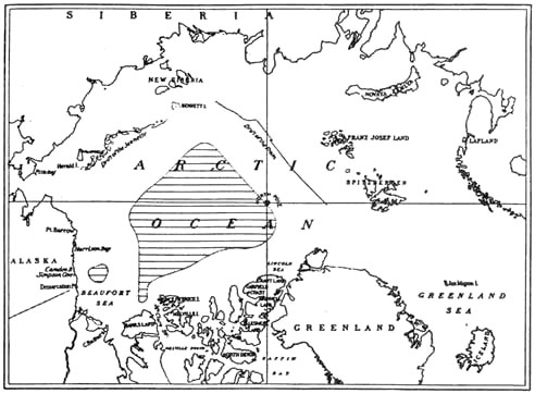
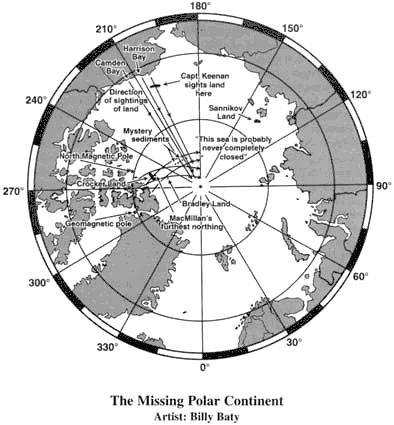
Figure. R.A. Harris' 1904 map showing hypothesized land near the pole [2].
Various arctic explorers actually reported seeing land in the distance, though it should be noted that visibility can be very poor, and mirages are very common. In 1811 Jakov Sannikov reported that he had seen a vast land to the northwest of the New Siberian Islands; it was named Sannikov Land. E. Moll claimed to have seen it twice, in 1886 and 1893, and it was marked on maps. Nansen did not find Sannikov Land during his expedition, nor have any later expeditions found it, and it is now thought to have been an ice island. Eskimos in Alaska have sometimes reported seeing hilly land to the north in the bright, clear days of spring. Land in this vicinity was seen by Captain John Keenan and his crew in the 1870s [3]. However, no such land has been discovered.
Crocker Land
Another famous disappearing land is Crocker Land, 'discovered' by Peary. He first saw it on 24 June 1906 from the top of a 2000-ft mountain situated behind Cape Colgate in northern Greenland. He wrote: 'North stretched the well-known ragged surface of the polar pack, and northwest it was with a thrill that my glasses revealed the faint white summits of a distant land which my Eskimos claimed to have seen as we came along from the last camp.' A few days later, on 28 June, Peary was at Capt Thomas Hubbard at the northern tip of Axel Heiberg Island. It was a clear day and, from the top of a 1600-ft hill, Peary says that through his binoculars he was able to 'make out apparently a little more distinctly, the snow-clad summits of the distant land in the northwest, above the ice horizon'. At both locations Peary built cairns in which he left a brief record.
Peary estimated that Crocker Land lay 120 miles from the northern coastline of Axel Heiberg Island. In 1914 his friend, Captain Donald B. MacMillan, led an expedition to find it. On 16 April he left Cape Thomas Hubbard with Ensign Fitzhugh Green and two Eskimos, Pewahto and Etukishuk. They trekked out onto the frozen polar sea, bypassing many leads of ice-free water. By the evening of 21 April they were nearly 100 miles from shore, yet nothing was in sight on the horizon, even though the mist had cleared. The next morning, however, MacMillan was inside their igloo when he heard Green shouting excitedly that Crocker Land was in sight. In his diary he wrote:
We all rushed out and up to the top of a berg. Sure enough! There it was as plain as day -- hills, valleys, and ice cap -- a tremendous land extending through 150 degrees of the horizon. We had even picked out the point to head for when Pewahto remarked that he thought it was mist . . . resembling land. As we watched it more narrowly its appearance slowly changed from time to time so we were forced to the conclusion that it was a mirage of the sea ice. This phenomenon has fooled many and many a good man . . . [4]
They thought they could see land again in the morning of the 23rd, but it had faded away in the afternoon when the sun worked south and west. Though they advanced a total of nearly 150 miles, they found no land, and MacMillan concluded: 'my dream of 5 years is over.'
After returning to shore, the party found one of Peary's cairns and retrieved his message. Although he had seen Crocker Land from this spot, the record read simply: 'Peary, July 28, 1906.' MacMillan looked out to sea and thought he could see land as well. He believed that if he had been there in Peary's place, he would have declared the discovery himself. Later, Peary's other cairn was discovered. The message it contained stated that on the day Peary claimed to have first seen Crocker Land he had 'a clear view of the northern horizon', yet there was again no mention of land.
Wally Herbert draws attention to the fact that Peary's diary entries for both days also make no mention of his discovery of new land to the northwest. Nor do the telegrams he sent out on his voyage home informing his sponsors of his achievements. Only in his book Nearest the Pole, published in 1907, did he mention 'Crocker Land', which he named after one of his financial backers. Herbert thinks that both Crocker Land, and his highly dubious claim to have set a new 'farthest north' on the same expedition, may have been forced upon Peary by his desperate need to be given one final chance to reach the north pole [5].
Bradley Land
Frederick A. Cook stated that on his journey to the north pole in 1908, he looked for Crocker Land but did not find it at the location given by Peary. However, he said he had seen a mountainous, ice-clad land slightly further from shore, which he named Bradley Land. He saw it to the west of his line of march north across the pack on 30 March 1908, and again on 31 March. It extended from 83°20'N to 85°11'N and was located at about 102°W longitude. It appeared to consist of two islands, and had an elevation of about 1800 feet at its highest points [6].
Later exploration has not found any land at that location. However, in the late 1940s aerial reconnaissance did reveal a number of large 'ice islands' -- breakaway pieces of the ancient ice shelf -- drifting slowly clockwise in the arctic basin north of Ellesmere Island. Several arctic researchers have suggested that Cook may have mistaken one for land. However, ice islands are much smaller than the features Cook described, and only rise about 25 feet above sea level. Some Cook partisans therefore claim that the ice island Cook saw was not 40 miles away, as he thought, but only 2 miles away, but since Cook claims to have seen Bradley Land in clear weather, this is unconvincing.
One thing is certain: the photograph of Bradley Land that Cook included in My Attainment of the Pole (1911) does not show an ice island but real, ice-clad land. Cook supporters tend to agree, but say that, as with some of the Mount McKinley photos, Cook may have used a photograph of a body of land resembling what he had seen as a substitute for the actual but probably poor-quality photo! Others, like Wally Herbert, see the photo as evidence that Cook faked his north-pole journey [7]. Cook's Eskimo companions are reported to have stated that Cook had not seen Bradley Land and that the photograph in his book was taken off the northwest coast of Axel Heiberg Land.
Prior to his attempt at the pole, Cook had expressed the common belief that land would be found in the Arctic Ocean. He said it was reasonable to expect some rocky islets north of Greenland, perhaps extending as far as the 85th parallel, and that any land would probably have an elevation of at least 1000 feet. His faith in Harris's 1904 paper on the likelihood of a polar continent was probably reinforced by Peary's claim of seeing Crocker Land. It seems that Cook took a calculated gamble by claiming to have seen Bradley Land and marking its location on his map. On his return journey, he supposedly came to within 11 miles of Bradley Land, yet he said he had not see it, though his Eskimos had seen it while he was asleep. But he did not make any effort to reach it and confirm its existence [8].
As evidence of how Cook's story evolved, it is worth nothing that, in contrast to his later book on his polar expedition, he stated in one of his notebooks that he did in fact see Crocker Land, on 30 March 1908, and he even gives a detailed description. He also stated that he first sighted Bradley Land on 4 April, rather than 30 March, and that on his return journey he saw both Crocker Land and Bradley Land [9]!
Cook asserted that he encountered an island of old, glacial land ice between 87° and 88°N, only 120 miles from the north pole, and travelled over it for portions of two days. He was astonished to discover this island of ancient glacial ice so many hundreds of miles from land. Although it is now known that drifting islands of old glacial ice do exist in the region of the higher Arctic, Cook's photograph of the glacial land ice has proven fraudulent. Wally Herbert discovered that Cook did not print the entire plate in his book. In the Cook Collection at the US Library of Congress, he found an uncropped lantern slide that shows an enormous piece of rock on the right-hand side of the ice. In other words, the glacier is visibly resting on dry land of unknown extent, yet Cook made no mention of this.
Since there is no known land close to the north pole, Herbert and others regard the photo as further evidence that Cook was a liar [10]. The incriminating lantern slide was originally discovered back in 1913 by Evelyn Briggs Baldwin, and led him to renounce his belief in Cook [11]. Cook supporters, on the other hand, trot out their familiar argument that Cook must have used a substitute photograph for 'illustrative purposes'! In his book, Cook expressed uncertainty as to whether the glacial island was floating ice or was resting on land beneath sea level. This may have served as a hedge that some such feature might be discovered, since this part of his route lay across the zone Harris thought might hold an unknown continent.
A mega-conspiracy?
Jan Lamprecht takes quite a different view of Cook and Peary and the controversy surrounding them. Despite all the evidence against them, he believes that they were both perfectly honest, though he admits that Peary's sanctioning of a campaign of vilification against Cook is inexcusable. He believes that both reached the north pole, that their sightings of Bradley Land and Crocker Land were genuine, and that Cook's photo of Bradley Land is authentic. To salvage their reputations, however, he has to invoke a conspiracy of incredible proportions. He argues that one or more polar lands in the north polar region have in fact been discovered -- not where Peary and Cook thought they were, but north of Alaska, some 5° short of the north pole -- and that they lie near or just within a polar opening measuring 100 or 200 or more miles across. He claims that the military and government authorities of Russia, America, Canada, and perhaps other nations have perpetrated an unprecedented coverup to hide these revolutionary discoveries [12]!
Lamprecht argues that the 'land' seen by MacMillan and his men in 1914, with its snow-capped peaks, white summits, and undulating landscape, was not a mirage of sea ice but a 'telescopic mirage' of an enormous polar land in the mid-Arctic lying about 250 to 350 miles from where it was sighted. He also argues that Peary's sightings of Crocker Land were telescopic mirages of the same landmass, dismissing the evidence that he made the story up. On rare occasions, the atmosphere can in fact behave like a telescope. For instance, in 1939 a captain of a schooner and his crew saw landmarks of Iceland as though at a distance of 25-30 nautical miles instead of the actual 335-350 statute miles [13].
Mirages are very common in the Arctic, and frequently involve multiple images lying above the object producing the mirage. These images are usually distorted and upside-down but sometimes the topmost image is the right way up, though it may be vertically compressed. However, neither Peary nor MacMillan saw an inverted image. Lamprecht suggests that the land in question may lie on the inward-curving surface of a polar opening, and that from Peary or Macmillan's vantage point the lower (inverted) image was blocked by the sharp curvature, even though it was seen from locations over 100 miles apart. To explain the enormous lateral extent of the mirages seen by MacMillan (though apparently not by Peary), Lamprecht speculates that the land had been magnified horizontally. Nevertheless, for the mirage to extend over a third or more of the horizon, without any noticeable degradation in brightness, the land itself would still have to be enormous.
Lamprecht believes that Cook's photo of Bradley Land may also be a telescopic mirage, probably of the easternmost extension of Crocker Land, which he thinks is located on the earth's outer surface, but is being covered up because it lies too close to the polar hole. He thinks that Keenan Land could also be a telescopic mirage of the same gigantic polar continent (seen at a distance of over 900 miles!), but that this is probably not true of Sannikov Land given the direction in which it was sighted. He believes that Sannikov Land may lie further away than was originally thought and that the Russians may be keeping it under wraps because it lies too close to the polar hole (though this is difficult to understand from his map -- see below) [14].
How plausible are such stories of a vast, international, perfectly leak-proof conspiracy to conceal the existence of a polar land, a polar opening, and a hollow earth? Given the widespread belief in the possibility of a large polar continent in the early 20th century, if any land were sighted why would it immediately have been hushed up? After all, if it were lying half-within a reasonably large polar opening, this unexpected fact would not be immediately obvious, and it is hard to see why the military would immediately impose total secrecy.
Despite the large number of military and government personnel -- from several different countries -- who, over the years, must have been involved in perpetuating the alleged coverup and secretly exploring the supposed polar land(s) and opening, and perhaps even the earth's interior, not the slightest leak has ever taken place. And despite the fact that some of the countries involved were enemies during the Cold War, there have apparently been no territorial disputes and no wars over the inner world's resources. Such a conspiracy seems rather unlikely.
Lamprecht believes the polar land and hole might have been discovered in 1926, when Amundsen, Ellsworth, and Nobile made their transpolar flight from Spitzbergen to Alaska. But instead of publicizing their discoveries, they supposedly went straight to the military, and were sworn to secrecy. And even when a bitter dispute broke out between Amundsen and his Italian pilot, Nobile, over credit for the flight, neither of them broke the silence about the supposed discovery of a polar hole.
It is interesting to note that the British Transarctic Expedition from Point Barrow in Alaska to Spitzbergen from February 1968 to April 1969, led by Wally Herbert, passed very close to the spot where Lamprecht places his hole. Lamprecht suggests that Herbert's slow speed may have been caused not by the need to make detours around pressure ridges, but by the need to make a detour around a polar opening. He even implies that Herbert is involved in a campaign of 'sophisticated deception' to conceal the hole's existence, and suggests that Herbert's 'nasty hatchet job' on Cook and Peary is aimed at discrediting the evidence for Crocker Land and Bradley Land. Needless to say, Lamprecht does not have a shred of concrete evidence to support this wild accusation.
If there is any land or a polar opening in the region of the north pole, they would surely interfere with the drift of the pack ice. In this regard, Wally Herbert makes an interesting observation about his experience on the Transarctic Expedition:
We began to feel there must be some obstruction along the imaginary line which describes a circle around the Pole at a radius of 260 miles -- a hump, perhaps, over which ice drifting north could not pass. No less than four times since the end of October [1968] we had drifted towards 86°N, coming at one time to within an hour's walk of that imaginary obstacle -- only to slip back again to 85°30'N, the latitude at which we had moved our hut after the first winter floe had broken up. We had hoped to establish our winter quarters at latitude 88°N, and be carried by the trans-polar drift stream across the Pole. Had this plan materialized, it would have left us with less than 600 miles to sledge to make landfall on Spitzbergen. But we had failed to get farther north than 85° before we had had to turn back and return to our summer floe. And the winter drift, which we had expected to transport us to latitude 87°N, longitude 140°W by 1 March 1969, had instead carried us 130 miles off course to the east.
Nansen had faced a similar problem during his epic drift in the Fram. After the first eighteen months, it had become evident that the thirteen-man crew of the Fram were unlikely to come closer to the Pole than 300 miles unless they left the warmth and safety of the ship and set out on foot. [15]
Although it is often said that the Arctic Ocean and seafloor have been thoroughly explored, it should be borne in mind that this ocean is one and a half times the size of the USA. So the possibility of a small opening, or island with tunnel, having gone undiscovered cannot be absolutely ruled out. As far as the possibility of a 'coverup' is concerned, it is worth noting that according to some mystical and esoteric traditions, certain sacred areas of the earth are protected and concealed by the exercise of occult power (see part 4, section 2).
The south geographic pole was first reached on 14 December 1911 by the Norwegian explorer Roald Amundsen. On 17 January 1912 it was reached again, via a different route, by a British team led by Captain Scott, who was distressed to find Amundsen's flag already there. On their return journey, all five members of the team perished during a blizzard.
Hollow-earthers have not been able to find many anomalies in Antarctica to explain in terms of a polar entrance to the earth's hollow interior. Some have argued that the southern opening is smaller than the northern one, or that it is completely blocked with ice. No modern hollow-earther argues that there is an opening centred on the south pole itself; the south pole is clearly a single point that can be reached by different routes, situated on a plateau with an elevation of 10,000 feet. Since 1956 there has been a permanently manned scientific base there.
In 1929 Richard E. Byrd became the first man to fly over the south pole; unlike his northern polar flight, this one aroused no major controversy! However, Byrd went on to lead several major expeditions to Antarctica, collecting valuable scientific information and flying over vast reaches of the continent, mapping its coast and mountain ranges. Some hollow-earthers have devoted a lot of time to distorting his findings and statements to support the idea of large polar openings.
In 1959 F. Amadeo Giannini published an extremely weird book entitled Worlds Beyond the Poles, in which he put forward his theory that the earth was linked to the moon and planets by a continuous land surface! He quoted a radio announcement supposedly made by Byrd from his arctic base in February 1947: 'I'd like to see that land beyond the Pole. That area beyond the Pole is the center of the great unknown' [1]. He claimed that on this northern polar flight, Byrd had flown 1700 miles 'beyond the earth' before returning to his base, and had passed over
iceless land and lakes, and mountains where foliage was abundant. Moreover, a brief newspaper account of the flight held that a member of the admiral's crew had observed a monstrous greenish-hued animal moving through the underbrush of that land beyond the Pole. [2]
Giannini interpreted the 'land beyond the pole' to be celestial land connecting the earth with the moon and other planets!
His story about Byrd's 1947 flight was repeated in the December 1959 issue of Flying Saucers in a sensational article written by the editor, Ray Palmer, who used it to support the hollow-earth theory. Palmer claimed that Byrd must have flown part-way into the earth's hollow interior, and that this truth had been covered up. He also argued that flying saucers came from within the earth.
There was one small problem with the story about Byrd: in February 1947 he was officially in the Antarctic, not the Arctic! He was Officer in Charge of the huge US Navy Antarctic Expedition, Operation Highjump, involving 13 ships manned by 4000 men. According to his article on the expedition in The National Geographic (October 1947), Byrd arrived in Little America on 29 January 1947. On 15 February two planes, one of them piloted by Byrd, flew to the south pole, and then into the 'mystery land beyond the pole', as Byrd calls it. They flew about 100 miles to latitude 88°30'S, then turned eastward until they reached the 45th east meridian, when they turned back to Little America. Altogether they surveyed nearly 10,000 square miles of 'the country beyond the pole'. According to Byrd, all they saw there was a 'rolling white desert from horizon to horizon'. Byrd says that this flight from the base and back covered 1800 miles and took 12 hours. They evacuated Little America on 23 February and arrived back in the US on 14 April.
Some of Ray Palmer's readers pointed out these facts to him, and in the February 1960 issue of Flying Saucers he said that in his opinion the flight in question was into the opening at the south pole, and that Giannini had falsified the north-pole flight. Giannini, however, stuck to his guns, and claimed that in 1947 Byrd had flown to the Arctic after leaving the Antarctic! He even claimed that the New York Office of US Naval Research had allowed him to transmit a radio message of godspeed to Admiral Byrd at his arctic base! Giannini asserted that Byrd's north-pole flight was reported by the New York Times and several other publications until censorship was imposed from Washington. Palmer says that his readers turned every library in the country upside down but found nothing to confirm the north-pole flight [3]. So either Giannini was a blatant liar or he suffered from a highly confused and unbalanced state of mind. Another serious problem with the supposed north-pole flight is that while February is summer in Antarctica, it is winter in the Arctic -- and perpetual darkness does not provide ideal conditions for a flight to the north pole, or for sighting 'a monstrous greenish-hued animal moving through the underbrush'!
In 1955/56 Byrd led another huge expedition to Antarctica, known as Operation Deepfreeze. In his book, Giannini quoted the following radio announcement: 'On January 13 [1956] members of the United States expedition accomplished a flight of 2,700 miles from the base at McMurdo Sound, which is 400 miles west of the South Pole, and penetrated a land extent of 2,300 miles beyond the pole' [4]. Byrd's account of the expedition in The National Geographic (August 1956) states that in 10 flights from the McMurdo Sound base, between 3 and 14 January, US Navy long-range planes observed approx. 800,000 square miles of Antarctica previously unseen by human eyes. On 8 January Byrd flew from McMurdo Sound over the 'area of inaccessibility' in the heart of East Antarctica, and then to the south pole. By the time he got back he had flown 2310 miles in just over 11 hours.
Palmer and other hollow-earthers assumed that Byrd flew 2300 miles beyond the south pole in one direction, and pointed out that this would be beyond Antarctica -- unless it had been into a polar opening! But it is clear that when Byrd speaks of 'the mysterious land beyond the pole', he simply means the unexplored part of the Antarctic continent, 'beyond' the south pole from the point of view of the US base on the Ross Ice Shelf.
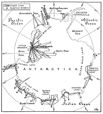
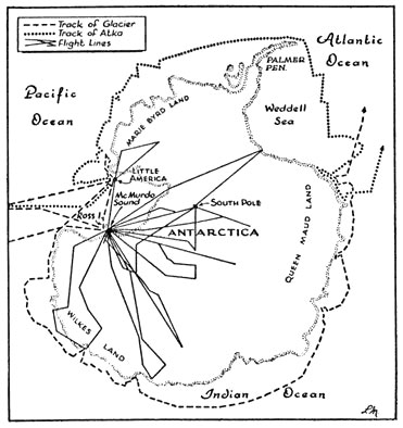
Figure. Flights made during the 1947 and 1956 expeditions to Antarctica [5].
The nonsense spread about Byrd's expeditions reached its climax in the publication of the 'secret' diary of his supposed 1947 flight beyond the north (!) pole [6]. It records how, as Byrd draws nearer to the pole, he passes over green valleys and sees an animal resembling a mammoth. Then suddenly three flying saucers marked with swastikas appear from nowhere and cause his plane to land by exercising a mysterious force. Byrd is escorted by two tall, blond, handsome men with German accents to a wise, aged man called the Master, who informs Byrd that he has passed into the inner world of the Arianni. The Master tells him that surface humanity must cease tampering with atomic power or suffer a new Dark Age of destruction. 'Byrd' also records that on returning to the outer world, he was ordered by top security forces to remain silent. Remarkably, there are still a few hollow-earthers who take this piece of silliness seriously.
During the US Navy's 1947 exploration of Antarctica, a number of ice-free areas were found with fresh-water lakes amidst brown, barren rock hills [7]. The most remarkable of them, situated near the Queen Mary Coast of Wilkes Land in southeastern Antarctica, was entirely free of ice over at least 300 square miles -- Admiral Byrd called this 'the most surprising discovery of the expedition'. The lake contained countless billions of green, blue-green, red, and brown algae. The favoured explanation was that rock areas exposed by a retreating glacier or by prevailing winds would absorb a great deal of heat in the summer months of perpetual daylight, and this would slowly be reradiated. Subterranean heat sources were suspected in some cases. The German antarctic expedition to Queen Maud Land in 1938-39 also made some surprising discoveries, including a 'group of low-lying hills sprinkled with many lakes and completely free of ice and snow', resembling the barren hot springs region of Iceland [8]. However, none of this constitutes serious evidence for a southern polar opening.
Jan Lamprecht presents a couple of extremely tenuous arguments for openings at both the north and south poles [9]. He argues that long-delayed radio echoes might result from radio waves entering the earth's interior through a polar hole, bouncing around inside the earth, and then exiting again. And he suggests that the movement of air into and out of polar holes might explain certain meteorological phenomena, such as strange clouds sighted in Britain and America. He also refers to the fact that after the Chernobyl nuclear power plant accident in April 1986, scientists discovered a high concentration of radioactive fallout 38 km from the south pole, deposited in late 1987 or early 1988, some 20 months earlier. It is known that radioactive fallout from nuclear tests in the northern hemisphere takes 20 months to reach the south pole. However, Lamprecht says that this is the only spot in the southern hemisphere where Chernobyl fallout has been found, and believes that since the radioactive material was not detected crossing the equator, it must have travelled into the north-pole opening and out of the south-pole opening.
5. Auroras and the poles
The auroras seen in the polar regions are one of nature's most beautiful and mysterious phenomena. From space the aurora appears as a diffuse ring surrounding the polar regions, roughly centred on the geomagnetic pole. From the ground it can take the form of luminous arcs, bands, and patches, and at its most dramatic it appears as a shimmering, multicoloured curtain of light, rippling and swirling, everywhere broken up into spikes and streamers moving across the sky -- apparitions that the Vikings called 'the spears of Odin'. Auroras are generally aligned along the direction of the local magnetic field.
As William Corliss points out, even 'normal' auroras have not yielded up all their mysteries:
Auroras are loosely associated with solar activity and geomagnetic storms, so we surmise that gusts of electrically charged particles emitted by the sun (the solar wind) help in some way to set fire to the polar heavens. But beyond these generalities, there is much we do not understand. [1]
He adds that abnormal auroras, such as auroras near the earth's surface and auroras with curious geometries, 'reveal even deeper levels of ignorance about one of Nature's most spectacular manifestations'.
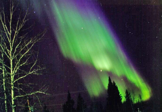
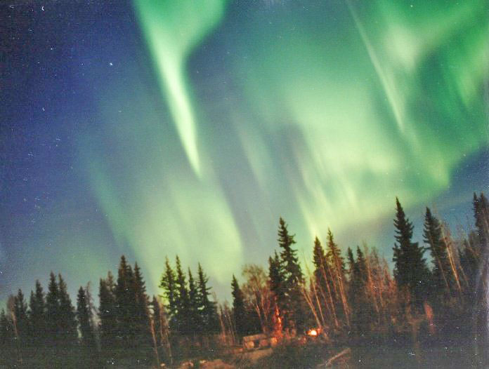
Figures. The aurora borealis [2].
The standard explanation is that auroral light is produced by a high-vacuum electrical discharge powered by the sun [3]. 98% of the charged particles (mainly electrons and protons) reaching the earth from the sun are deflected by the earth's magnetic field, while the rest manage to enter the comet-shaped magnetosphere -- though exactly where and how is unclear -- and are then stored in some unknown way. The particles that produce the auroras are believed to emanate from the plasma sheet inside the earth's magnetotail. They are accelerated to speeds near one-fifth that of light (200 times their original speed) -- again by some unknown mechanism -- and are steered by the magnetic field to the polar regions. Here they descend into the atmosphere and generate the aurora when they collide with and ionize oxygen and nitrogen atoms in the ionosphere, at heights from over 900 km to about 70 km. Because the ions are in an excited state, they emit radiation of various wavelengths, creating the characteristic colours of the aurora (yellow-green, blue, and red or purplish-red).
In The Aurora Watcher's Handbook, Neil Davis writes:
Amazingly enough, auroral scientists still do not understand why aurora occurs in discrete auroral forms instead of as a diffuse glow across a broad region of the sky. The reason somehow has to be bound up in the way matter in the plasma state behaves . . . [4]
Scientists believe that most of the universe is in the plasma state (the fourth state of matter), a plasma being an ionized gas, i.e. a gas in which at least some atoms have dissociated into positive ions and free electrons. The entire region from the centre of the sun to the bottom of the earth's ionosphere is said to be in the plasma state. Scientists acknowledge that they still have much to learn about plasmas. Indeed, theosophy implies that what is currently labelled 'plasma' sometimes includes higher states of matter.
Scientists have suggested mechanisms to explain auroral motions and shape changes. A major factor is believed to be the warping of the incoming particle streams by attendant magnetic and electric fields, but it is thought that additional mechanisms may be operating. The cause of the variation in the brightness of auroras and in the general level of activity over periods of several minutes is unknown.
The auroral breakup is the most active and spectacular part of a moderate to large auroral display. It is generally followed by a 'pulsating aurora', far weaker and less bright, consisting of patches of light blinking on and off in a regular pattern ranging from 0.1 sec to over 20 sec. This activity may continue for the rest of the night. Such pulsations sometimes overlie the stronger auroral activity too. The cause of these pulsations is unknown, but they are usually accompanied by geomagnetic pulsations.
Auroras in the northern hemisphere tend to be brighter than those in the southern hemisphere. Auroral displays in the two hemispheres are often mirror images of each other, but sometimes this conjugacy fails altogether, especially at higher latitudes. A startling finding is that pulsating auroras, on the other hand, are always exactly synchronous at opposite ends of the earth; they vary in brightness at exactly the same times within a fraction of a second, despite the fact that they are only quasi-periodic and have a strong random element. This points to a common, as yet unidentified cause, perhaps located in the equatorial plane, equidistant from the two poles.
Low-level (less than 60 km) and ground-level auroras are supposed to be impossible, as incoming particles should not have enough energy to penetrate that far into the atmosphere. However, there are very reliable reports of such phenomena. In addition to low-level auroras, evidence that terrestrial electricity may sometimes be discharged from the earth into the atmosphere during auroral displays includes the fact that some auroras tend to follow coastlines, the odours of ozone, sulphur, and/or 'electricity' detected in conjunction with low-level and high active auroras, and the surface electric effects associated with auroras [5]. Also anomalous is the fact that geomagnetic storms and auroras sometimes appear to correlate with thunderstorms, clouds, and atmospheric pressure [6]. Charged particles from the sun should not have enough energy to affect the weather, though some scientists think auroras somehow act as a trigger.
Another puzzling phenomenon is auroral sound -- swishing, rushing, crackling, and hissing sounds sometimes heard during auroral displays [7]. Current theory places auroral displays so high that the near-vacuum of the atmosphere should not transmit audible sound effectively. Moreover, several minutes should elapse between seeing the aurora and hearing sound, yet auroral sound tends to synchronize to some extent with auroral motion, suggesting that conventional sound generation and transmission are out of the question, except perhaps in the case of genuine low-level auroras. Theories include direct perception of electromagnetic radiation from the aurora as sound, electrical discharge at the earth's surface induced by the aurora, and very-low-frequency waves generated by solar-wind particles acting on transducers such as hair.
Although auroras are more intensive during the highs of the 11-year solar cycle, not every solar flare triggers an aurora. It appears that while the sun feeds charged particles to the earth, the earth itself somehow controls the aurora. There is a certainly reason to doubt that the aurora is caused solely by charged particles from the sun. An alternative theory, proposed in the mid-20th century, is that the aurora is not caused primarily by solar particles but by electric currents originating in the earth which flow to the north and south magnetic polar regions and are then inducted to the atmosphere, where they ionize the gases in the higher, more rarefied layers of the atmosphere, producing the aurora. Finally, the electricity returns to the earth in lower latitudes, forming a continuous circulation of electricity through all parts of the crust and atmosphere. This theory readily allows for auroras to be produced in the lower atmosphere when atmospheric conditions allow [8].
Neil Davis explains that there is still some uncertainty as to how the auroral light is generated:
Direct excitation by particle impact is a certainty, but some observations suggest that other processes may also be operating. These may involve heating by electric fields and interactions between ionized atmospheric constituents and various types of electromagnetic waves that pervade the medium. Questions still remain about all the processes that go into producing two of the aurora's brightest and most simple emissions, the oxygen red and green lines at 6300 A and 5577 A, and the cause of the 'enhanced aurora' remains a mystery. [9]
Auroral displays are sometimes accompanied by magnetic and electric disturbances, but not always. A possibility ignored today is that there are also subtler processes at work. Baron von Reichenbach in the 19th century and Wilhelm Reich in the 20th century argued that auroras partly result from the luminating properties of ethereal energy-substances pervading the atmosphere [10]. Reichenbach called this subtler substance odyle, and Reich called it orgone; both became convinced of its existence in the course of numerous experiments. Aurora-like glows can be produced in high-vacuum tubes that have been charged in an orgone accumulator and are simply stroked with the hand; no electrical excitation is involved here.
In 1716 Sir Edmund Halley (of Halley's Comet fame) suggested that some of the luminous atmosphere lighting the inner shells in the earth's hollow interior might be escaping through the much thinner crust at the poles, thereby producing the auroras. Lyon and Sherman believed that the earth's more highly developed interior world generated its own aural light, and that the auroras in the polar regions were largely caused by ethereal elements emanating from the interior world and emerging through polar openings [11].
Captain John Symmes, William Reed, and Marshall Gardner also invoked polar openings in their explanations of the auroras, but their views cannot be taken seriously: Symmes claimed that the auroras were caused by the sun's rays reflecting off the internal oceans; Reed argued that the aurora was due to the reflection on the clouds, ice, and snow of burning volcanoes and prairie or forest fires in the earth's interior; and Gardner argued that the aurora was caused by rays of light from the inner sun shining out of the large polar openings but being modified by clouds and other conditions of the inner and outer atmospheres. Jan Lamprecht speculates that charged particles from the outer sun are accelerated by circling repeatedly through the inner earth via polar openings some 200 miles across, and suggests that the electrons involved in pulsating auroras originate in the pulsating inner sun and are expelled through the polar holes.
According to theosophy [12], the aurora borealis and aurora australis are not merely electric and magnetic displays but are manifestations of the subtler psychomagnetic vitality of the earth. They are intimately linked with the sun, especially the sunspots, and are also connected with inrushes and outrushes of different types of monads or consciousness-centres both to and from our globe. Like earthquakes, the auroral discharges in one of their functions dissipate what would otherwise become an overaccumulation of magnetic and electric energy within the earth.
The magnetism reaching us from the sun -- physical, astral, and mental -- is said in theosophy to enter the earth in the region of the north pole. Part of it then passes directly from pole to pole through the centre of the earth, while other parts sweep over its surface from north to south, either meridionally or diagonally. At the south pole, some of it streams outwards into space and ultimately returns to the sun, while the rest returns to the north pole, either through the earth's interior or over its surface, and is then sent forth again. Clearly, known physical particles such as electrons and protons, along with photons (packets of electromagnetic energy), cannot pass through a solid earth. This would not apply, however, to neutrinos and more etheric energy-substances.
G. de Purucker says that the sun is both the heart and brain of its kingdom.
If you look upon it as the heart for an instant, it receives the influxes of the rivers of lives, the circulations of the solar system, in its north pole. They pass through the heart of the sun, are cleansed and washed and leave at the south pole of the sun. Precisely as our earth and every other planet have each its receptor at the north pole, and its ejector or vent at the south pole.
He then refers to the Greek legend of Eolus and the cave of the winds, in which the cave stands for the earth, and the winds are the winds of the spirit, the circulations of the cosmos. The cave had two 'gates': the gate of horn in the north, through which the gods mainly descend but also ascend, and the gate of ivory at the south, out of which go the hordes of men.
In other words, the earth feeds itself physically, magnetically, psychically, spiritually, through the north pole. The currents sweep through the earth -- every word here is worth a volume -- and leave by the south pole. So it is with the sun. That is the way the sun feeds its family: just as the heart feeds the body. It sends out its blood through the south pole, as it were, and after the circulation around the body has taken place, it receives it in again at the north pole. [13]
References
1. The open polar sea
[1] W.R. Corliss (comp.), Neglected geological anomalies, Glen Arm, MD: Sourcebook Project, 1990, pp. 118-9; W.R. Corliss (comp.), Science frontiers: Some anomalies and curiosities of nature, Glen Arm, MD: Sourcebook Project, 1994, p. 204.
[2] Wally Herbert, Across the top of the world: The British trans-arctic expedition, London: Longmans, 1969, p. 17.
[3] 'Arctic', Encyclopaedia britannica, CD-ROM, 1994-2000.
[4] Neglected geological anomalies, pp. 114-5.
[5] Jan Lamprecht, Hollow planets: A feasibility study of possible hollow worlds, Austin, TX: World Wide Publishing, 1998, p. 399 (http://www.hollowplanets.com).
2. The north pole controversy
[1] 'Arctic', Encyclopaedia britannica, CD-ROM, 1994-2000.
[2] Jan Lamprecht, Hollow planets: A feasibility study of possible hollow worlds, Austin, TX: World Wide Publishing, 1998, pp. 362-5.
[3] Robert M. Bryce, Cook & Peary: The polar controversy, resolved, Mechanicsburg, PA: Stackpole Books, 1997, pp. 1101-3.
[4] Wally Herbert, The noose of laurels: The discovery of the north pole, London: Hodder & Stoughton, 1989, p. 260.
[5] Ibid., p. 308.
[6] Cook & Peary, p. 879.
[7] Ibid., pp. 795-844.
[8] The noose of laurels, pp. 298, 331-8.
[9] Sheldon S.R. Cook, 'Reflections on the polar "noose of laurels" 1909-1999', Polar Priorities, vol. 19, September 1999, pp. 13-37.
[10] Cook & Peary, pp. 861-9, 910-1.
[11] Ibid., pp. 881-2, 890-900, 969-75.
[12] Ibid., p. 844.
[13] 'Richard E. Byrd', Encyclopaedia britannica, CD-ROM, 1994-2000; Cook & Peary, pp. 1115-6.
3. Polar land coverup?
[1] Robert M. Bryce, Cook & Peary: The polar controversy, resolved, Mechanicsburg, PA: Stackpole Books, 1997, pp. 266-7.
[2] Ibid., p. 885.
[3] Jan Lamprecht, Hollow planets: A feasibility study of possible hollow worlds, Austin, TX: World Wide Publishing, 1998, pp. 417, 429.
[4] Cook & Peary, p. 570.
[5] Wally Herbert, The noose of laurels: The discovery of the north pole, London: Hodder & Stoughton, 1989, p. 197.
[6] Cook & Peary, pp. 407-8.
[7] The noose of laurels, pp. 317-9.
[8] Cook & Peary, pp. 884-5, 1105.
[9] Ibid., pp. 893-4.
[10] The noose of laurels, pp. 319-20.
[11] Cook & Peary, p. 886.
[12] Hollow planets, pp. 434-42, 485-95, 499-500.
[13] William H. Hobbs, 'A remarkable example of polar mirage', Science, vol. 90, pp. 513-4, 1939; W.R. Corliss (comp.), Rare halos, mirages, anomalous rainbows and related electromagnetic phenomena, Glen Arm, MD: Sourcebook Project, 1984, pp. 143-5.
[14] Hollow planets, p. 493.
[15] Wally Herbert, Across the top of the world: The British trans-arctic expedition, London: Longmans, 1969, p. 152.
4. Flights of fancy
[1] F. Amadeo Giannini, Worlds beyond the poles: Physical continuity of the universe (1959), Mokelumne Hill, CA: Health Research, 1977, p. 13.
[2] Ibid., p. 151.
[3] Raymond Bernard, Flying saucers from the earth's interior, Mokelumne Hill, CA: Health Research, n.d., pp. 48-9, 84-5; Walter Kafton-Minkel, Subterranean worlds: 100,000 years of dragons, dwarfs, the dead, lost races & UFOs from inside the earth, Port Townsend, WA: Loompanics Unlimited, 1989, p. 196.
[4] Worlds beyond the poles, p. 14.
[5] Joscelyn Godwin, Arktos: The polar myth in science, symbolism, and nazi survival, Grand Rapids, MI: Phanes Press, 1993, p. 128.
[6] The missing diary of Admiral Richard E. Byrd, New Brunswick, NJ: Abelard Productions, 1990; http://www.v-j-enterprises.com/byrdiar.html.
[7] Richard E. Byrd, 'Our Navy explores Antarctica', The National Geographic Magazine, October 1947, pp. 429-522 (Plate VIII, and pp. 475, 498-500).
[8] The polar myth in science, symbolism, and nazi survival, p. 126.
[9] Jan Lamprecht, Hollow planets: A feasibility study of possible hollow worlds, Austin, TX: World Wide Publishing, 1998, chs. 11, 12, pp. 500-3.
5. Auroras and the poles
[1] W.R. Corliss (comp.), Lightning, auroras, nocturnal lights, and related luminous phenomena, Glen Arm, MD: Sourcebook Project, 1982, p. 7.
[2] The Aurora Page, http://www.geo.mtu.edu/weather/aurora/images/aurora/jan.curtis.
[3] 'Atmosphere', Encyclopaedia britannica, CD-ROM, 1994-2000; Neil Davis, The aurora watcher's handbook, Fairbanks, AK: University of Alaska Press, 1992.
[4] The aurora watcher's handbook, p. 173.
[5] Lightning, auroras, nocturnal lights, pp. 16-21, 44-7; W.R. Corliss (comp.), Science frontiers: Some anomalies and curiosities of nature, Glen Arm, MD: Sourcebook Project, 1994, p. 255; Science Frontiers, no. 119, Sep.-Oct. 1998, no. 127, Jan.-Feb. 2000; Anomaly Register, no. 1, Feb. 1997.
[6] Lightning, auroras, nocturnal lights, pp. 24-6, 28-30, 39-41; The aurora watcher's handbook, pp. 179-81; Jan Lamprecht, Hollow planets: A feasibility study of possible hollow worlds, Austin, TX: World Wide Publishing, 1998, pp. 334-9.
[7] W.R. Corliss (comp.), Earthquakes, tides, unidentified sounds and related phenomena, Glen Arm, MD: Sourcebook Project, 1983, pp. 169-76; Corliss, Science frontiers, p. 287; Harriet Williams, 'Sizzling skies', New Scientist, 6 January 2001, pp. 14-19; The aurora watcher's handbook, pp. 183-203.
[8] N.V. Hendricks and N.V. Hendricks, Jr., Polar-electrical theory of the aurora borealis-australis and terrestrial magnetism, Adrian, MI: Edwards Brothers, Inc., 1945.
[9] The aurora watcher's handbook, p. 174.
[10] Reichenbach's letters on od and magnetism (1852), Mokelumne Hill, CA: Health Research, 1964, pp. 78-83, 113-14; Wilhelm Reich, Ether, god and devil: Cosmic superimposition, New York: Farrar, Straus and Giroux, 1973, pp. 141, 239-47.
[11] M.L. Sherman and Wm.F. Lyon, The hollow globe; or the world's agitator and reconciler. A treatise on the physical conformation of the earth (1871), Mokelumne Hill, CA: Health Research, 1971, pp. 289-90.
[12] G. de Purucker, Fountain-source of occultism, Pasadena, CA: Theosophical University Press, 1974, pp. 306-7; H.P. Blavatsky, The secret doctrine (1888), Pasadena, CA: Theosophical University Press, 1977, 1:204-5.
[13] G. de Purucker, Studies in occult philosophy, Pasadena, CA: Theosophical University Press, 1973, pp. 321-2; Fountain-source of occultism, pp. 305-8. See Theosophy and the hollow earth,