|
CHAPTER 16 – THE MISSING CONTINENT
Despair
I was very frustrated and terribly depressed at the thought that even though
I had come this far, I still had nothing concrete to offer with regard to
the physical location of a Polar Hole. I had been conducting this study for
some years, writing this book, and examining the evidence without knowing
what my final conclusion would be regarding Polar Holes. Everything had gone
so well, except for the Arctic. I had scrutinized everything – photos,
science, the whole lot. I took out atlases, bought the finest maps, and
there was just nothing to be seen. Not the faintest clue. I only had two
areas to look into before winding up my Arctic research. Then I would have
to admit that I could find no physical evidence of Polar Holes. Hollow Earthers had often claimed that islands and even mountain ranges had been
struck off Arctic maps. They tried to demonstrate that all polar navigation
was unreliable – but this of course was not true. I studied this aspect
closely and could find no evidence to suggest that polar navigation was
highly flawed. On the contrary, it was amazingly accurate.
I began wondering if these ‘missing lands’ might be related to the elusive
anomalous curvature I was look for. I wondered if these islands and
mountains really existed inside Polar Holes. The other issue had to do with
the discovery of the North Pole. Could the Cook/Peary controversy perhaps be
related to the Hollow Earth? The only connection I could see were the issues
regarding sledding speeds and navigation. Since these resulted in dead-ends,
I could not see how there could be any further connection between these two
diverse subjects. Bit by bit, as I followed up the ‘missing lands’ problem,
radical new thoughts began falling into place. Let us now set off on the
final leg of our journey in search of the Earth’s elusive Polar Holes.
The Polar Continent
Take a look at any map in any atlas. It shows the Arctic Ocean to be nothing
but an ice-covered sea. The Arctic Ocean is quite shallow, but even so there
are no islands in it beyond a certain latitude. There most definitely is no
Polar continent in the Arctic. Yet, many explorers and geographers once
believed there was something there. The Americans Marshall Gardner and
William Reed collected a great deal of evidence to show that animals, birds,
fish and whales originated from inside a Polar Hole. Many explorers wondered
why some birds would fly north as winter was setting in, instead of going
south. Hence Gardner and Reed wondered if these animals came from a warmer
land further north, inside a Polar Hole. They were not alone in their
thinking, however, There were geographers and explorers who thought these
things could be explained in terms of a Polar continent. To some, the idea
of the Open Polar sea tied in with the existence of this continent, and a
few thought there might be a relatively warm continent up near the North
Pole.
Peary had once thought that volcanic activity of some kind was taking place
further north in the Arctic. During his North-Greenland Expedition of
1891-1892 he mentioned the following incident:
“(An Eskimo)
Megipsu told me
of a heavy fall of black dust or soot during an east wind at Cape York about
a year ago which frightened the natives seriously. In this neighborhood the
fall was lighter. I could get no further particulars, but as to the general
truth of the story I have little doubt. It seems strongly to indicate the
possibility of volcanic dust having reached that region, perhaps from some
northern area still unexplored.”
There are no volcanoes to be found further
north in the Arctic. Nor can continents be found in the Arctic Ocean on any
modern map of the Arctic.
Sannikov Land
The Sankt-Petersburg’s Academy of Science (Russia) organized a research
expedition in 1808-1810. They set off for the Novosibirsky Islands which are
situated between the Laptev Sea and the East Siberian Sea. In 1811
Jakov
Sannikov, a member of the expedition, claimed that he had seen a vast land
to the north or north-west of Kotelny Island which is a part of
Novosibirsky
Islands. This vast land which he reported was named Sannikov Land in
honor
of him. In the years that followed the Sankt-Petersburg’s Academy of Science
arranged for other expeditions to this area. E. Moll took part in these
expeditions and he claimed to have seen Sannikov Land twice, once in 1888 and
again in 1893. Sannikov Land was marked on maps.
No one had visited it yet,
although it had been seen on the horizon on the three occasions mentioned
above. Nansen, the polar explorer firmly believed Sannikov Island existed.
He hoped to find it when he drifted across the Arctic in his ship, the
“Fram”. Nansen’s is unquestionably one of the most brilliant, daring, and
successful Arctic expeditions ever undertaken. Even so, Nansen never did
find Sannikov Land. The Russians were absolutely convinced
Sannikov Land was
real and they later mounted new expeditions to find it. “The Big Soviet
Encyclopedia” states:
“In spite of an intensified search in the first half
of the 20th century, the so-called Sannikov Land hasn’t been found. In the
opinion of some explorers, this land has been destroyed by the ocean as has
happened to many other islands made mainly of fossil ice.”
So what had Sannikov and Moll then seen? Had they really only seen an ice-island? It had
been seen on three occasions in a period of 82 years.
Sannikov Land therefore remains something of a mystery because it was seen
on at least three occasions and was marked on maps. Sannikov Land might, or
might not be, related to a larger mystery. There is, however, one
possibility which I would venture to propose. What if the Russian
expeditions earlier this century did indeed find something but kept it under
wraps? Although this is mere speculation, it is a possibility which cannot
be excluded. My thoughts regarding Sannikov Land therefore remain
inconclusive.
Crocker Land
The most famous ‘disappearing land’ of all is
Crocker Land, originally seen
by Peary in 1906. He saw it twice through binoculars and then proceeded to
mark it on his maps. In 1914 Captain (later Admiral) MacMillan,
Peary’s
great friend and admirer, set out to find Crocker Land. History records the
fact that MacMillan’s expedition never did find Crocker Land. In fact,
MacMillan concluded that Crocker Land was a mirage. Scientists and polar
experts these days agree with MacMillan’s assessment and Crocker Land has
long been struck from our maps. If everyone is in agreement, then what is
the mystery?
What exactly did Peary see? When? And where? I June 1906 Peary was surveying
the northern coastline of Canada. On 24 June he decided to climb a 2,000 ft
mountain which was situated inland, behind Cape Colgate. In his book
“Nearest the Pole” he described what he saw as he looked out over the Arctic
Ocean:
“North stretched the well-known ragged surface of the polar pack, and
north-west it was a thrill that my glasses revealed the faint white summits
of a distant land which my Eskimos claimed to have seen as we came along
from the last camp.”
A few days later, on 28 June, Peary was at
Cape Thomas
Hubbard at the northern tip of Axel Heiberg Island. Peary was unable to sleep
that evening, so he hitched his dogs to a sledge and drove it 1,600 ft up a
hill.
“The clear day greatly favored my work in taking a round of angles,
and with the glasses I could make out apparently a little more distinctly,
the snow-clad summits of the distant land in the north-west, above the ice
horizon.”
Let us carefully examine the information contained in Peary’s original
statements:
1. He saw
Crocker Land through his field glasses
2.
He stood on high ground at the time of the sightings
3.
Crocker Land stood out above ice horizon
4. He personally saw Crocker Land
twice
5. The first time he describes seeing
‘white summits’
6. The second time he
describes seeing ‘snow-clad summits’
7. The
sightings were four days apart
8.
Crocker Land was slightly clearer on the second sighting
9. He saw Crocker Land in the same
direction from two different vantage points
10. Peary also informs us that his
Eskimos claimed to have seen the white
summits of Crocker Land some time on or before the 24th as they came from
their last camp
Since Peary’s sighting of Crocker Land has generally been dismissed as a
mirage, I did not think much of Crocker Land until Dr. Gohnert and I
stumbled upon a “Times of London” newspaper article printed on 20 July 1908.
It concerned Peary’s upcoming attempt at reaching the North Pole and his
thoughts on the matter. Peary made a remark which shows that he definitely
believed Crocker Land to be a real land mass.
It was this article which
first brought Crocker Land to my attention and made me realize that
Peary
thought it was absolutely real. Peary had reckoned distances from
Crocker
Land, and he even intended sending a party of his own men there on his
return journey from the North Pole. Crocker Land was marked on many maps
during this time because everyone, including Peary, seemed to be utterly
convinced of its existence.
Let us now take a look at Captain MacMillan’s 1914 expedition to find Crocker Land. MacMillan describes this expedition in his book “Four Years in
the White North”. MacMillan desperately wanted to go back to the
Arctic.
There was only one place left to go, the Unexplored region which Peary
referred to in his 1908 press release. MacMillan tells us he did not go
searching for Crocker Land based on Peary’s testimony alone:
“My decision to
return into the frozen North was not actuated by this single report.
Richardson, McClure, Marcus Baker, Capt. John Keenan, and
Dr. R. A. Harris
have all given reasons for the existence of such a land. This belief has
persisted for nearly ninety years. The accumulated evidence of years
substantiated Peary’s belief.”
It is often stated that MacMillan never found anything as he ventured out on
to the Arctic Ocean. However, that is not the full story. As they struggled
across the pressure ridges, they kept a constant watch for Crocker Land.
Nothing. Still they continued forth in their north-westerly quest. They had
now journeyed seventy-eight miles out onto the Polar sea while bypassing
many leads. Then, when they were approximately 100 miles from the shore,
something very extraordinary happened, the likes of which has never been
recorded in the history of exploration:
“April 21st was a beautiful day; all
mist was gone and the clear blue of the sky extended down to the very
horizon. Green was no sooner out of the igloo than he came running back,
calling in through the door, ‘We have it!’ Following Green, we ran to the
top of the highest mound. There could be no doubt about it. Great heavens!
What a land! Hills, valleys, snow-capped peaks extending through at least
one hundred and twenty degrees of the horizon.
I turned to Pee-a-wah-to
anxiously and asked him toward which point we had better lay our course.
After critically examining the supposed landfall for a few minutes, he
astounded me by replying that he thought it was poo-jok (mist).
E-took-a-shoo offered no encouragement, saying, ‘Perhaps it is.’
Green was
still convinced that it must be land. At any rate, it was worth watching. As
we proceeded, the landscape gradually changed its appearance and varied in
extent with the swinging around of the Sun; finally at night it disappeared
altogether. As we drank our hot tea and gnawed the pemmican, we did a good
deal of thinking.
Could Peary with all his experience have been mistaken?
Was this mirage which had deceived us the very thing which had deceived him
eight years before? If he did see Crocker Land, then it was
considerably more than 120 miles away, for we were now at least 100
miles from shore, with nothing in sight...
To increase our latitude we set a more
northerly course on the 23d and 24th, with a variation of 178 degrees
westerly. Observations on these two days put us ahead of our dead-reckoning
in latitude 82 degrees 30 minutes, longitude 108 degrees 22 minutes, 150
miles due north-west from Cape Thomas Hubbard. We had not only reached the
brown spot on the map, but we were thirty miles in-land! You can imagine how
earnestly we scanned every foot of that horizon – not a thing in sight, not
even our almost constant traveling companion, the mirage. We were convinced
that we were in pursuit of a will-o’-the-wisp, ever receding, ever changing,
ever beckoning.”
Lt. Col. Molett’s explanation for Crocker Land was that clouds and snow are
easy to confuse. He alluded to a horizon which was whitish. In this close-up
encounter with Crocker Land, MacMillan tells us that the sky was blue all
the way down to the horizon. Crocker Land therefore stood out against his
blue background. The mystery continued to deepen after MacMillan and his men
turned back for they continued to see this mysterious, yet unattainable
land. They struggled to find their trail through a blinding snow storm.
April 26th was a fine day, but MacMillan makes no mention of Crocker Land on
that day. They reached igloos 7, 6, and 5 on that day’s long march. Then,
six days after the sighting quoted above, he wrote:
“On the 27th we marched
from igloo No. 5 to No. 4 in the same perfect weather and perfect going, all
leads being frozen. Throughout the day the mirage of sea ice, resembling in
every particular an immense land, continued to mock us. It seemed so near
and so easily attainable if we would only turn back.”
MacMillan believed
Crocker Land to be a mirage of sea-ice. We will study the scientific aspects
of his sightings in greater detail later. But first we need to understand
the facts he presents. Crocker Land seems to have a peculiar aspect to it.
It always seems to be close at hand, yet by now MacMillan knows better! They
seem to see Crocker Land during extremely clear weather, when conditions are
‘perfect’. This makes Crocker Land difficult to explain as some kind of
optical illusion. They see it on the clearest days – seemingly for hours at
a stretch. Note his terse description of it as “resembling in every
particular an immense land…”
MacMillan’s final sighting of Crocker Land took place from
Cape Thomas
Hubbard, and it is every bit as spectacular as the previous sightings:
“We
now turned eagerly to an examination of the Polar Sea. Peary stood here in
June, 1906, and from this very spot he saw what resembled land lying to the
north-west, 120 miles distant. The day was exceptionally clear, not a cloud
or trace of mist; if land could be seen, now was our time. Yes, there it
was! It could even be seen without a glass, extending from south-west true
(sic) to north-north-east. Our powerful glasses, however, brought out more
clearly the dark background in contrast with the white, the whole resembling
hills, valleys, and snow-capped peaks to such a degree that, had we not been
out on the frozen sea for 150 miles, we would have staked our lives upon its
reality. Our judgment then, as now, is that this was a mirage or loom of
the sea ice.
That there is land west of Axel Heiberg Land
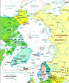 ("click"
right map) – not north-west,
as some scientists would have us believe – I have no doubt. I would limit
the eastern edge of this land to 120 degrees west longitude, and the
northern to 82 degrees north latitude for the following reasons: Our eight
days’ travel out from Cape Thomas Hubbard was over ice which had not been
subjected to great pressure, evidence that it was protected by some great
body of land to the west against the tremendous fields of ice driven on by
the Arctic current, which has its inception north of Bering Strait and
Wrangel Land, across the Pole, and down the eastern shore of
Greenland. ("click"
right map) – not north-west,
as some scientists would have us believe – I have no doubt. I would limit
the eastern edge of this land to 120 degrees west longitude, and the
northern to 82 degrees north latitude for the following reasons: Our eight
days’ travel out from Cape Thomas Hubbard was over ice which had not been
subjected to great pressure, evidence that it was protected by some great
body of land to the west against the tremendous fields of ice driven on by
the Arctic current, which has its inception north of Bering Strait and
Wrangel Land, across the Pole, and down the eastern shore of
Greenland.
At
our farthest north, 82 degrees, all was suddenly changed. The long, level
fields ended in a sharp line going east and west; beyond this line there was
the roughest kind of ice, which had evidently been pushed around the
northern point of this unknown land over shoal ground extending toward the
north.”
In the above, MacMillan affirms, for the last time, that
Crocker
Land resembles real land in every ounce of detail. He speaks of the contrast
between light and dark. He mentions, again, ‘show-capped peaks’ – with its
implications for color and contrast. MacMillan’s sighting from
Cape Thomas
Hubbard is even more amazing than Peary’s. Peary only saw the land faintly
above the horizon with his field glasses.
But MacMillan sees it with the
naked eye. Most astounding of all is his description that on this occasion
it covers an even wider field of view than happened during his sighting out
on the Polar sea. This time it stretches from the south-west through north
to north-north-east. It is as if all of MacMillan’s sightings of Crocker
Land are much ‘closer’ and even more real looking than those of
Peary in
1908. It is true they saw a mirage, but it was an incredible mirage the
likes of which has never been reported before or since.
What we have here is excellent testimony that for long periods of time a
mystery land becomes visible in the Arctic. But what could cause this?
Mirages in the polar regions are distortions of something physical on the
ground. This is an important fact. Mirages on a hot day result from light in
the sky being refracted so that the ‘water’ we see on the ground in fact
comes from clouds in the sky. Mirages in the polar regions are the opposite.
Here we normally see mirages in the sky which are caused by objects which
lie on the ground.
Polar mirages are therefore a reflection or distortion of
something physical. Yes, Crocker Land is a mirage. But a mirage of what? We
are not dealing with magic and witchcraft. We are dealing with science, and
Crocker Land remains unexplained in scientific terms, especially when we
take into account MacMillan’s multiple sightings.
Why should the same land be seen continually in only this one direction?
This consistency suggests that this mirage is indeed related to something
physical. The sea-ice theory is flawed, but no one has been able to better
it yet. One has to ask how sea-ice can produce an effect so real that it is
:
(a) the right way up
(b) has the right
color contrasts
(c) has the right
shape
(d) has the right proportions and dimensions to fool
Peary, MacMillan,
Green and even some of their Eskimos
Crocker Land did not vary in
direction. Crocker Land was right there eight years after
Peary had seen it.
And it lay in exactly the same direction and could be seen from the same
spot again. On each occasion its reality was so great that no one doubted it
was real – except when they realized they could not reach it.
There is one final aspect which makes the description of Crocker Land unlike
anything ever seen before. Its sheer dimensions are staggering. MacMillan
describes it as covering at least 120 degrees of horizon. In his final
sighting the frontage seems to be even greater. I know of no mirage with a
frontage that wide. It covered a full one-third of a circle, if not more.
What could have created a mirage this spectacular?
MacMillan made it clear that the impetus for the expedition resulted from
testimony other than Peary’s. In Appendix VII of his book he records:
“Statements concerning the possible existence of land in the Polar sea.
Captain Richardson, in his work “The Polar Regions”, says ‘The Eskimos of
Point Barrow have a tradition, reported by Mr. Simpson, surgeon of
the
Plover (in 1832) of some of their tribe having been carried to the north on
ice broken up in a southerly gale, and arriving, after many nights at a
hilly country inhabited by people like ourselves, speaking the Eskimo
language, and by whom they were well received. After a long stay, one spring
in which the ice remained without movement they returned without mishap to
their own country and reported their adventures. An obscure indication of
land to the north was actually perceived from the masthead of the Plover
when off Point Barrow.”
“In 1850, Captain McClure, when off t he northern coast of Alaska, wrote in
his journal that, judging from the character of the ice and a ‘light shady
tint’ in the sky, there must be land to the north of him.”
“Marcus Taker, writing in the ‘National Geographic’
magazine 1894, under the title of An Undiscovered Island off the Northern Coast of Alaska, says: ‘It
is often told that natives wintering between Harrison and
Camden Bays have
seen land to the north in the bright, clear days of spring. In the winter of
1886-87 Uxharen, an enterprising Eskimo of Ootkearie was very anxious for me
to get some captain to take him the following summer with his family, canoe,
and outfit to the north-east as far as the ship went, and then he would try
to find this mysterious land of which he had heard so much; but no one cared
to bother with this venturesome Eskimo explorer.”
“The only report of land having been seen in this vicinity by civilized men
was made by Capt John Keenan of Troy, New York, in the seventies (1870s) at
that time in command of the whaling-bark Stamboul of New Bedford. Captain
Keenan said that after taking several whales, the weather became thick, and
he stood to the north under easy sail and was busily engaged in trying out
and stowing down the oil taken. When the fog cleared off, land was
distinctly seen to the north by him all the men of his crew, but as he was
not on a voyage of discover, and there were no whales in sight, he was
obliged to give the order to keep away to the south in search of them.”
“In June, 1904, Dr. R. A. Harris of the United States Coast and Geodetic
Survey, published in the ‘National Geographic’ magazine his reasons for
believing that there must be a large body of undiscovered land or shallow
water in the polar regions. He based his theory upon the report that
Siberian driftwood had been picked up in South Greenland, upon the
observation of drifting polar ice, upon the drift of the ship Jeannette, and
upon numerous tidal observations made along the northern coast of Alaska and
eastward.”
Polar Images
The polar regions are well known for their mirages. A mirage is an optical
illusion caused by the refraction of light passing through layers of
atmosphere of varying density. Mirages are often seen in warm climates. The
inferior image is the most common type seen under these conditions. The air
above a hot surface lies in layers of varying density. An inferior mirage
causes the distant, nearly level desert surface to assume the appearance of
a sheet of water, especially if one observes from a slight elevation or
simply from a point above the heated layer.
The same effect occurs over a
hot road. The ‘water’ is really an image of the sky. One can sometimes
observe objects below eye level on this ‘water’ surface. These objects are
usually inverted. Superior mirages are found in cold regions and in
conditions where there are strong temperature inversions. They are less
common and more spectacular than inferior images. Distant objects (often
over a sea horizon) are seen upside-down in the sky. There may also be an
upright image of the same object above the inverted one.
When such a mirage
is seen on land, all the trees and other landscape features are inverted,
and in all cases of superior mirage, the images are more clearly defined
than in an inferior mirage. Superior mirages are not, as is commonly
supposed, caused by reflection from a surface above the spectator. The
explanation is complicated and involves the action of the wave fronts of
light as they progress through strata of varying density.
Was Crocker Land a mirage? Definitely. Firstly, MacMillan’s Eskimos declared
it to be ‘mist’. Mirages are unstable. Nevertheless, in spite of its amazing
stability, Crocker Land had to be a mirage. They watched it change during
the day as the Sun moved. Furthermore, it did not lie 120 miles from shore
as Peary had thought. As MacMillan approached it, he found it receding.
Also, when in fact he knew it could not possibly be. Now if Crocker Land was
not a mirage of something much further away? Could this be true for Keenan
Land and for Sannikov Land too? Could these lands somehow be related? Could
these be different views of one single gigantic missing Polar continent?
There is an aspect of the mirage theory which poses a problem. Superior
images are normally upside-down! Nobody ever said these lands were
upside-down. If these explorers had seen upside-down, they would have
mentioned it. These mirages were so real-looking in every detail that no one
suspected they were mirages until someone went closer. The most common
incarnation of a superior mirage results in a distorted upside-down image.
Less often however, superior mirages have another image above them which is
the right way up.
Could it be that Crocker Land is an instance where, for
some unknown reason, we are only seeing the top image? If so, then why don’t
we see the lower inverted image? I have not come across any mention that
only the top part of such a mirage can be visible. What could cause this?
The only reasonable explanation for Crocker Land must be the one which at
first seems impossible Crocker Land can only be caused by mountains and real
land somewhere nearby in the Arctic Ocean. It must lie 200 or 300 miles from
where Peary and MacMillan saw it. But it can’t be too far away
or else the
light would not be able to travel that distance through the atmosphere.
Can people see mirages of real objects over a considerable distance? Billy Baty, who helped with this book, told me the following story about a mirage
of the city of Corpus Christi:
“… People in the Rio Grande valley not too
far from where I live have seen a mirage of a city on many occasions. It was
discovered the mirage city was Corpus Christi which is a hundred or so miles
away. I actually knew a man who saw the mirage city on at least two
occasions. Apparently the image would last for hours and when it would
disappear, you could drive a small distance and see it again. Sometimes it
would appear on the following day.”
There are a number of instances where
objects have been seen which are below the horizon. There are also a number
of instances where objects have been seen at a considerable distance as if
they were magnified by some kind of ‘atmospheric lens’. (Examples given are
omitted in this summary except for this final one.)
Captain Robert Bartlett
was in command of the schooner Effie M. Morrissey. He had experience sailing
in polar waters for forty years when he saw the clearest mirage of his life.
At 16h00 on 17 July 1939 his ship was between Cape Farewell on the southern
tip of Greenland and Iceland. The Sun was lying in the south-west when the
Captain and crew saw:
“… the Snaefells Jokull (4,715 feet) and other
landmarks (of Iceland)… were seen as though at a distance of
twenty-five or
thirty nautical miles (instead of the actual 335 to 350 statute miles). ‘If
I hadn’t been sure of my position and had been bound for Rejkjavik (Captain
Bartlett said), I would have expected to arrive within a few hours. The
contours of the land and the snow-covered summit of the Snaefells Jokull
showed up almost unbelievably near.”
We are therefore able to establish that
under certain strange atmospheric conditions, a mirage can be magnified to
make land appear to be 10 or more times closer than it really is.
Why isn’t Crocker Land on our maps by now? Even if MacMillan did not find
it, surely the USAF or US Navy should have found it decades ago? What of
the extensive Russian sea and air searches for Sannikov Land earlier this
century? Did they also come up empty-handed? Or did they find something they
would rather keep under wraps? The Russian and American military have
scrutinized every square inch of the polar regions. Maps made of the Arctic
Ocean seafloor by nuclear submarines of the US Navy were classified for 25
years. Could it be that Crocker Land does not technically belong to the
outer surface of the world? Could it be that Crocker Land lies ‘below the
surface’ of this Earth? Could it be that some strange geographic and
atmospheric conditions exist there which exist nowhere else on Earth? Could
it be that Crocker Land lies in a Polar Hole?
Now let’s think about that. Remember the debate I mentioned regarding
warm
or cold air exiting from an Inner Earth? Arctic mirages occur early in
spring and summer in this region where MacMillan and Peary were.
Peary saw
Crocker Land in June, while MacMillan saw it at its finest in April and May.
The geography of a Polar Hole must have some effect on temperature and
weather in the vicinity.
For example, would that land not lie in eternal
darkness throughout the winter? And what of the temperature of the air
coming from inside the Earth? Could this create a natural, circular belt of
air above, and around a Polar Hole? Could air from inside the Earth create a
naturally occurring temperature inversion in such a hole? Would this mean
that light from Crocker Land, Sannikov Land and
Keenan Land always passes
through certain layers which refract the light in a certain way? Are the
temperatures there causing light to be refracted along the curvature of the
Outer Earth? According to the various accounts I have presented, the Polar
continent seems to be enormous in size. Does the circular rim of a hole also
have a circular layer of air of a certain density which then causes a
natural focusing effect on light passing out of it? Could it result in
greater lateral magnification thereby making the land appear wider than it
really is? Would this explain why Crocker Land covered such a large
frontage?
Finally, why is the lower, inverted image of Crocker Land never seen?
Remember that anomalous Earth curvature which I hunted for so fruitlessly?
Well, maybe I’ve found it. What would happen if this mythical mountain
existed inside a Polar Hole where the curvature is much more pronounced?
Could it be that the anomalous curvature of a Polar Hole blocks the rays of
light which would normally form the lower inverted distorted image in a
superior image? Light rays carrying the superior image may be so refracted
that they are never seen by the human observer because of the curvature of
the Earth in the vicinity of a Polar Hole.
On the other hand rays carrying
the upright image are so refracted that they take a higher path through the
atmosphere and they are then seen by the observer. Could this be the
scientific explanation for Crocker Land, Sannikov Land and
Keenan Land? This
explanation neatly dove-tails with my other thoughts which suggest that
Crocker Land lies much further away than even MacMillan thought.
Crocker
Land could be 350 miles, and perhaps even more, away from where MacMillan
saw it on 21 April. The behavior of the pack-ice also suggested that
MacMillan was still far away from land.
Let us suppose someone were to set out towards Crocker Land and they did not
turn back. At first they may see it from time to time, as the weather
allows, as clearly as MacMillan and Peary did. As they approach it and begin
entering the Polar Hole, they will see it gradually rising in the sky. Below
it, gradually rising also, will be an inverted and distorted image of
Crocker Land. By now they should be seeing the mirage much more often. But
Crocker Land will still be far away. They will need to travel further still.
And as they do so, they will see both images still rising, and below these
images they will see the Crocker Land mountains – for real.
What will they find on Crocker Land when they finally set foot upon its
shores? As they wander through its hills and valleys, will they meet Eskimos
who technically are dwellers of the Inner Earth? Will these Eskimos be able
to direct them to the City of Shamballa?

|