|
The fact that physical evidence of such technology does exist is highly disturbing and lends support to the idea that an advanced race of flesh-and-blood Gods could have created us "in their own image"
This chapter covers a selection of sites which represent historical anomalies, based on my personal travels over the past few years. Many readers will already be familiar with places such as Tiwanaku and Nazca, whilst other readers will be totally unfamiliar. I will therefore attempt to strike a balance by keeping things reasonably briefly covering the essentials but also offering some fresh insights.
As those who have visited these places will appreciate, there is no substitute for being there. Indeed. I cannot count the times that I have been surprised to find things to be quite different from how I had imagined them to be. I am also including in this chapter some rather less familiar locations.
Chavin de Huantar, for instance, is interesting for its original,
highly advanced underground aqueduct systems, and I will be drawing
a fascinating parallel between these and the waterworks of Tiwanaku.
The difficulties of performing these manoeuvres,
even with twentieth century technology, are most enlightening! Some
of the sites not covered in this chapter are dealt with elsewhere.
The
pyramids of Giza, for instance, warrant a whole chapter in their
own right (chapter 4), whilst the ancient astronomical observatory
of Stonehenge is covered in chapter 5. A full discussion of the
astronomical aspects of Tiwanaku and Machu Picchu is also held
over until chapter 5.
Puma Punku is a classic example
of this approach, its precision-cut stones generally being excluded
from the archaeologists’ reports on the associated site of Tiwanaku.
For example, one of the most
prominent Egyptologists, Mark Lehner, recently led a team which
attempted to erect an Egyptian obelisk using ancient tools and
materials. The team had great difficulty explaining how the obelisk
was transported up the Nile, since loading it onto a boat seemed to
be physically impossible. The same team then had a dreadful struggle
to erect an obelisk which was only one tenth the size and weight of
the genuine article.
Unfortunately, not one of these experts has ever carried such a job through to completion, in order to show us how the stonemasons achieved perfect edges, especially the "inner edges’ of holes which are excavated into the face of the stone.
In this chapter, we will see several amazing examples of such stonework, which could not possibly have been produced by the simple stone or copper tools which the ancient people supposedly used. It is not my intention to speculate on exactly what kind of advanced technology was used to cut these stones, nor to answer the question of how they were moved over -impossible" distances and gradients. We map never know.
The question which I personally find more pertinent, and
equally fascinating, is "why did they do it?". It is at this point
that conventional scientists and historians attempt to distract us
from their lack of understanding by vaguely referring to primitive
religious beliefs. Some of the most curious anomalies in the world
are thus conveniently labelled as temples, altars and ritual baths,
when in fact their original purpose and function are totally
obscure.
Nevertheless, the significance of some objects is sufficiently clear
to frame the relevant questions. Among the questions which I will be
asking are: why were 800-ton stones used in a wall at Baalbek when
smaller stones would have been quite adequate: why were
sophisticated waterworks so important to the original designers of
Tiwanaku and Chavin? And why were the figures at Nazca designed only
for viewing from the air?
In due course, and at the appropriate time, I will revisit
nearly all of the sites in this chapter, to confirm their
chronologies and to offer my explanations of their functions or
meaning. In the meantime, I invite you to share my preliminary
thoughts on our mysterious past.
53 miles
north-east of Beirut. Baalbek was once one of the world’s most
sacred sites, and its temples one of the wonders of the ancient
world. In modern times, however, Baalbek lies forgotten - wiped off
the map by more than twenty years of warfare and terrorism. The site
has become so neglected that some archaeology books omit any mention
of it.
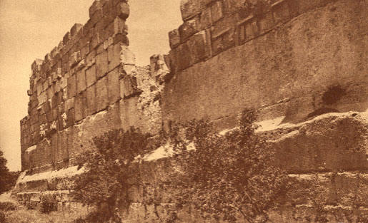
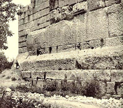
Only six pillars from that temple have survived the series of earthquakes which have laid the site to ruins, but these pillars, shown in Plate 1, still form a spectacular sight today, rising to a commanding height of 66 feet. The size of this temple literally dwarfs the Parthenon of Athens. However. as magnificent as the Temple of Jupiter certainly is, it stands on a pre-Roman terrace of colossal stones which is even more impressive.
At the bottom of Plate 1 can be seen a row of nine blocks in the south-east wall of the terrace, each measuring approximately 33 by 14 by 10 feet, and thus weighing more than 300 tons apiece.
At the same level in the adjoining south-western wall, we find six further 300-ton stones, above which are situated three enormous megalithic blocks, referred to as "the Trilithon" or the "Marvel of the Three Stones".
Plate 2 shows the three granite blocks of the Trilithon (the light colored course), forming the sixth visible layer of the wall. Each of these stones measures an amazing 64 feet in length (on average). with a height of 14 feet 6 inches and a thickness of 12 feet.?
They are estimated to weigh a staggering 800 tons each.
Michel Alouf, the former curator of the ruins, notes that:
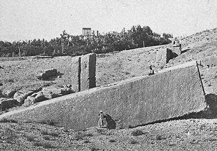
The angle of the photograph in Plate 2 (hampered by the perimeter fence) hardly does justice to the immense size of the Trilithon. Fortunately, however, its dimensions can be judged by a slightly larger block, known as the "Stone of the South", which lies in a nearby hillside quarry, ten minutes walk to the south-west.
Plate 3 demonstrates the huge scale of this stone slab, which measures 69 feet long by 16 feet wide by 13 feet 10 inches high.
This block is estimated to weigh around 1,000 tons, the equivalent of three Boeing 747 aircraft. How were the 500-ton stones of the Trilithon moved from the quarry to the acropolis? The distance is not huge, no more than a third of a mile. Nor is the elevation very different between the two points.
And yet, when one considers the size and weight of
these stones and the fact that the route from the quarry to the
acropolis is not entirely flat, transportation via any conventional
means presents a seemingly impossible dilemma. Furthermore, an even
greater mystery surrounds the manner in which the Trilithon stones
were then fitted more than 20 feet high into the wall, without
mortar and with perfect precision.
In addition, we have no evidence of any Roman technology that could have moved stones weighing 800 tons. In fact, there is no evidence of any known civilization having the technology to erect the colossal stones which we see in the terrace at Baalbek! Who could have built these huge stone foundations and why? It is a mystery that has inspired the imaginations of men for thousands of years. The Arabs believed that Baalbek belonged to the legendary Nimrod, who once ruled this area of Lebanon.
According to an Arabic manuscript found at Baalbek, Nimrod sent giants to rebuild Baalbek after the Flood, whilst another tale relates that Nimrod rebelled against his God and built the Tower of Babel at Baalbek.
Other legends associate Baalbek with the Biblical figure of Cain, the son of Adam, claiming that he built it as a refuge after his God Yahweh had cursed him.
According to Estfan Doweihi, the Maronite Patriarch of Lebanon:
It is sometimes claimed that modern cranes cannot lift stones as heavy as Baalbek’s 800-ton monoliths.
This is actually incorrect. I posed the problem of the Baalbek stones to Baldwins Industrial Services, one of the leading British crane hire companies. I asked them how they might attempt to move the 1,000-ton Stone of the South and place it at the same height as the Trilithon.
Bob MacCrain, the Technical Director of Baldwins, confirmed that there were several mobile cranes currently available that could lift and place the 1,000-ton stone on a support structure 20 feet high. Baldwins themselves operate a 1,200 ton capacity Gottwald AK912 strut jib crane, whilst other companies operate cranes capable of lifting 2,000 tons. Unfortunately, these cranes do not have the capability to move whilst carrying such heavy loads. How then might we transport the Stone of the South to the acropolis?
Baldwins suggested two possibilities. The first would use a 1,000-ton capacity crane fitted with crawler tracks. The disadvantage of this method would be the need for massive ground preparation works in order to provide a solid, level roadway for the crane to move. The alternative to a crane would be a series of modular hydraulic trailers, combined to create a massive load carrying platform.
These trailers raise and lower their loads using hydraulic cylinders built into their suspension. The initial lift at the quarry would be achieved by the use of a cut-out section beneath the stone, which the trailer would drive into. The final positioning in the wall, at a height of 20 feet, would be achieved by using an earth ramp. There is, of course, one slight problem with Baldwins’ solution. None of this twentieth century technology was supposedly available when Baalbek was built! What happens if we fall back on non-technological methods?
The usual suggestion is that megalithic stones were moved
using a system of wooden rollers. However, modern experiments have
shown such rollers being crushed by much lighter weights than 800
tons. Even if such a system was possible, it has been estimated that
it would take the combined efforts of 40,000 men to move the Stone
of the South. It remains completely unproven that an 800-ton stone
could have been moved using such primitive methods.
They
might thus have favoured large stones for a specific structural
reason, namely to provide a more stable platform which could withstand enormous vertical forces. An intriguing idea. On the other
hand, it is possible that the builders were simply in a hurry, and
it was therefore expeditious to cut and move one large stone rather
than two small ones. This does of course presuppose a high level of
construction technology being available.
It thus appears to form part of an unfinished defensive wall. This theory is reinforced by the Stone of the South, which is still attached at one point to the rocky floor of the quarry. The physical evidence indicates a sudden abandonment of the construction project. However, if the Trilithon layer represents a later addition, erected using high technology at an unknown time, then the layers below it must take us even further back into prehistory.
These lower layers in the south-western wall, have been carefully constructed of smaller stones, topped by a layer of 300-ton stones which have been shaped with an outward taper (Plate 2).
If we now move to the same level in the adjoining
south-eastern wall (Plate 1), we see a layer of megaliths, which
although of similar size, are ill-matched: some are tapered, others
are not, and the cut of the tapering does not match, even on
adjacent blocks. The unavoidable conclusion is that this upper layer
of the original platform has been reconstructed having once
sustained serious damage.
A major clue comes from the Greeks who called Baalbek "Heliopolis" - the city of Helios. According to ancient legend, Helios was a Sun God who could traverse the skies in his "chariot", and Baalbek was the alleged resting place of that chariot.
Could this legend explain the need for such massive foundations in the original platform at Baalbek?
Back to Baalbek - A Colossal Enigma
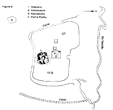
The site of Tiwanaku lies in a broad plain in the Rio Tiwanaku valley, one of several that cut back from the southern edge of Lake Titicaca into the huge plateau of the Bolivian altiplano.
Its colossal stone blocks may not equal those of Baalbek in size, but they lie at an altitude of 13.000 feet. Here, the air is so thin that tourists struggle to catch their breath, and the high level of ultraviolet solar radiation poses a constant danger to human eyes and skin.
Thousands of years ago, the lichen-encrusted ruins of Tiwanaku were home to the highest urban settlement of the ancient world.
Around AD 200, for reasons which are not entirely clear, Tiwanaku emerged as a sacred ceremonial centre. By AD 5001 it was the capital of an expanding empire - the first empire of the ancient Americas.
This empire, however, was not achieved by military conquest, but via economic power derived largely from huge agricultural surpluses. It was the collapse of the agricultural system, brought about by climatic change, that precipitated the end of the Tiwanakan era after 500 years of supremacy. The fact that Tiwanaku achieved agricultural surpluses at all is quite astonishing. Today, few farmers are brave enough to eke out an existence on the Bolivian altiplano, since hostile agricultural conditions bring total crop disaster every five years on average.
However, in ancient times this barren, windswept landscape had been transformed into a veritable oasis via a highly advanced agricultural technology. Archaeologists have found the remains of so-called "raised fields" which protected crops from frost damage and allowed miraculous yields to be achieved.
Experimental tests have shown this ancient
technology to be far superior to modern methods using fertilizers.
At its peak, the sacred city of Tiwanaku covered 2 square miles.
Its ceremonial core was surrounded by a moat, and the earth and clay
which had been excavated from the moat had been used to construct a
huge mound, known as the Akapana.
Writing in 1993, anthropologist Alan Kolata, who had spent many years excavating at Tiwanaku stated:
It is assumed that this "drainage" system was designed to collect rainwater in the Akapana’s central sunken court and feed it down to underground tunnels via the various terraces. The first component of this system was a major trunk line that led around the sides of the Akapana. Alan Kolata described this stone conduit as "finely crafted" and "precisely fitted", with the capacity to handle an "enormous flow".
This trunk line fed the water to the next lower terrace, where it flowed for around 10 feet in an exterior stone drain, before once again entering the Akapana. The alternating internal/external route continued until the water eventually exited ten feet underground via "beautifully constructed tunnels" - (Figure 7).
From here, the water drained into the Rio Tiwanaku and ultimately into Lake Titicaca.
Similarly sophisticated waterworks systems have been found at the nearby site of Puma Punku and at Lukurmata (near Lake Titicaca), even though these "temples" were otherwise quite different in design.
Once again the water flowed into canals which led to Lake Titicaca. Were these elaborate waterwork systems simply designed for drainage?
Alan Kolata acknowledged that the Akapana system was not a structural necessity:
Did the Tiwanakans really build these waterworks systems, as the archaeologists would have us believe, or did they inherit them from a much earlier, more advanced but unrecorded culture?
The evidence suggests the latter. One clue, which has mystified the archaeologists, is that the water systems of the Akapana had ceased to function at some time before AD 600, when the Tiwanakan empire was at its peak.
This was proved by the discovery of undisturbed human and animal remains, buried at key points in the structure, where they would have been affected if the waters had still been flowing. Another clue exists in the dating of human occupation at Tiwanaku to 1580 BC and 2134 BC using radiocarbon and obsidian dating respectively.
Both dates tend to suggest that the Akapana was important prior to the Tiwanakan emergence in AD 200. The anomalies continue if we move to the nearby site of Puma Punku, almost a mile to the south-west of the main ruins. Here we find the largest stones of Tiwanaku, some weighing over one hundred tons, representing the shattered remains of a partially excavated structure which is still not properly understood.
Plate 4 shows the scale of one of these huge red sandstone blocks, measuring approximately 26 by 16 by 2 feet and estimated to weigh 120 tons. Although badly eroded, the perfect lines of this and surrounding blocks can still be seen.
They have amazed countless travellers such as the Spanish chronicler Pedro Cieza de Leon who observed that:
Other stones at Puma Punku contain inexplicable grooves and niches, whilst some such as of metal clamps which were used of these clamps have actually been whereabouts are now uncertain. metal that is not associated with cultures at this time.
One of the Punku is shown in Plate 5.
This a precision-cut groove wide. Inside the groove, all of the seen equal distant drilled holes. grooves and holes have been made Figure 8 bear the indentations to fix the stones together.
Some found, although their They were made of bronze
- a any of the South American most impressive stones at Puma block,
several feet high, contains approximately 6 millimeters way from top
to bottom, can be. The question is, how could tiny using crude stone
hammers or
soft copper hand tools? On the contrary, to cut and drill stone with
this accuracy would require twentieth century technology.
On one side, the
Gateway features a carving of the deity Viracocha and his winged
attendants, but I would like to focus on the reverse side. Plate s
shows the Gateway’s series of enigmatic niches, which include
recesses for two hinges in the lower parts. These niches have been
cut into the stone with great precision, forming perfect inside
edges that could not possibly have been chiselled out using crude
and primitive tools.
In the background of Plate 9, there lies a most unusual piece of curved architecture, once again made of the very hard gray andesite stone. its front is elaborately carved and surrounded by nail holes, but its rear is stunning. It is difficult to find the superlatives to describe the perfect symmetry shown in Plates 6 and 7.
Perfect edges
are combined with a curved design which flares downwards and inwards
simultaneously. Try carving that one with stone tools! I have
mentioned here only a few of the many incredible stones that lie
strewn across the site of Tiwanaku, and it is worth emphasizing that
many more still lie buried in the ground under layers of sediment
from thousands of years of human occupation and periodic flooding
from Lake Titicaca.
My own impression was that the 12-feet high standing pillars of the Kalasasaya looked older than those of Stonehenge (dated to 2700-2300 BC) but not by an additional 7,500 years. On the other hand, the huge blocks at Puma Punku may well be a lot older than the Kalasasaya pillars, since they have spent much of their life covered in mud and protected from the elements.
The little history that we do have of Tiwanaku has been filtered through numerous later cultures, including the Incas and the Spanish conquistador’s who subjugated them in the sixteenth century.
Cieza de Leon, mentioned earlier, was intrigued by Tiwanaku, and recorded the myths that were handed down by the local inhabitants:
Similar legends claimed that Tiwanaku
was built in a single night,
after the Flood, by a mysterious race of giants - an explanation
reminiscent of Baalbek. Other myths described Lake Titicaca as the
sacred spot where the God Viracocha created the world. Another
legend, echoing the Bible, claimed Titicaca to be the home of a
patriarchal couple who had survived a great Flood and propagated the
Andean peoples. All of these tales are commonly cited to explain the
religious mystique which allowed Tiwanaku to expand in later times.
It is difficult to find a more remote
and better hidden location than Chavin de Huantar. And yet, 2,500
years ago, Chavin emerged as one of the most sacred cities in South
America, exerting a profound influence on the distant coastal
regions of Peru between 500-200 BC.
At
its peak, Chavin de Huantar covered 105 acres and its population
numbered around 3,000 - small by today’s standards, but an unusually
large size for Peru at that time.
On the contrary, archaeological
reconstruction’s of the site show a series of flat-topped temples,
surrounding three sides of a square, sunken plaza. These unique
"temples" rank among the oddest buildings of the ancient world.
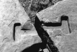
It contains a labyrinth of narrow subterranean passages, many of which inexplicably lead to dead-ends. One narrow passageway, however, allows access to an unusual vault in the form of a cross.
At this
juncture of passages, in the sacred heart of the temple, stands a
stone in the shape of a knife or lance projecting from the ceiling
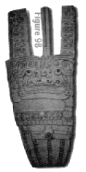
into the floor. This carved stone, shown in Figure 9a, is known as
El Lanzon - "the Lance".
The God has his right arm raised and left arm lowered, as if to convey some kind of message. Some commentators have noted the lack of a life line in the raised hand, suggesting that the God signifies death. Others see the image as benign and refer to it as "the smiling God of Chavin". Whilst the precise meaning of El Lanzon is uncertain, it is clear that the carved statue was of great importance.
The fact that its narrow, tapered upper section fits accurately through a tailor-made hole in the roof indicates that the temple must have been designed around the statue. It therefore seems as if this sacred relic was deliberately hidden away in the depths of the temple, in such a way that it could not be removed. Why did the priests go to such lengths to hide and protect their divine idol?
A clue may exist in the irregular shape of the granite (especially at the front) which suggests that the stone was damaged before the carving was made. If that was the case, the stone may have already been sacred.
It is possible that the Chavin priests carved El Lanzon and hid it to protect it from further damage.
The outside walls of the Old Temple were once adorned with more than two hundred frightening stone heads, some animal but mostly human.
Only one of these gruesome heads remains in its original position (Plate 10). The fangs and large nose are typical of the Chavin heads, as is the strange knob-shaped protrusion on the top. The meaning of these features is a mystery. It seems particularly strange that such unwelcoming stone faces would have greeted the pilgrims who made the gruelling journey to Chavin.
Why did Chavin de Huantar suddenly emerge as a religious centre? Why did pilgrims trek through almost a hundred miles of extremely difficult mountain terrain to reach it?
Clearly there was
something very special about this place something that is not
readily apparent from the sprawling ruins of the
temples which have been dated to around 500 BC. Does
Chavin have a secret, earlier past?
In her book Chavin de Huantar - A Short Eternity, archaeologist Nancy Abanto de Hoogendoorn described:
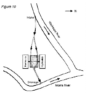
(Figure 10) shows the flow of water from the Wacheqsa intake, a short distance to the west, underneath the site to the Mosna river immediately to the east. Several hydraulic channels brought the waters together in a subterranean gallery and fed it underneath a square sunken plaza.
On one side of the plaza stood a large rectangular building known as the Northern Platform. Hoogendoorn has described the interior of the Platform as "a large passage, completely made of sculpted stones and a quite profound hydraulic system". It is thought that the heavily damaged Southern Platform on the opposite side of the plaza had a similar function to its northern counterpart.
The two platforms can be seen in Plate 11,
either side of the sunken plaza. Finally, all of the flowing waters
converged underground at a point just beyond the plaza, where they
were then drained by a single channel to the Mosna river.
The obvious answer is drinking water and sewerage, but if this was the case, then it was over-engineered on a massive scale, and would be quite without precedent in the ancient world. Another theory suggests that the builders designed the hydraulic system to counter the risk of flooding, supposedly by regulating the flow of the Wacheqsa river.
It is difficult to see how this idea would have worked in practice,
and if the risk of flooding was known in advance, why would anyone
set down their roots in such a vulnerable position? There are plenty
of other, safer locations in the vicinity.
It is a fact that water is absolutely essential for most industrial processes.
Few clues remain at the site to establish exactly what
these processes might have been, but one authority has recently
suggested the panning of gold as a possibility. An old Incan legend
indeed speaks of gold, silver and precious stones hidden somewhere
beneath the temples. Unfortunately, the first proper excavations of
Chavin de Huantar, begun in 1919 by Julio Tello, were never
completed, because in January 1945 an enormous flood buried the site
under ten feet of mud and stones. Since then, archaeological efforts
have concentrated on restoring the site to its previous condition.
Could Chavin have once been an industrial centre and could the key to its sacred importance lie in its secret past?
It may be no coincidence
that the over-engineering of the Chavin waterworks is mirrored by a
similar level of unnecessary complexity in the Akapana waterworks at
Tiwanaku...
The Incan empire which they found was huge and enormously wealthy, with gold reserves beyond the Spaniards’ wildest dreams of avarice. However, it was also an empire plagued by internal strife, which made it extremely vulnerable.
The
Incan gold proved to be a temptation that truly changed the course
of history, leading to a long war in which the Spaniards brutally
subjugated the native people. Remarkably, the Incan empire which
they destroyed was totally devoid of writing, plunging the prior
history of much of South America into an obscurity that can only be
partially enlightened by oral traditions.
From that point, it
would seem, the Incas became oppressive dictators, building their
empire by the ruthless enslavement of the surrounding tribes.
However, according to an exhaustive analysis carried out by the Spanish historian Fernando Montesinos, the mean Manco Capac was in fact named after an earlier Manco Capac, who had started civilization at Cuzco thousands of years before the Incas. Montesinos recorded the local beliefs that 62 kings had reigned at Cuzco for approximately 2,500 years and that 28 kings had then ruled at Tampu-Tocco for around 1,000 years.
This, the only chronological record of Andean prehistory, takes us back to a date of 2400 BC. At that time, the original Manco Capac had come to Cuzco from the sacred Lake Titicaca on the orders of the God Viracocha, who had given him a golden wand or staff. What exactly might this wand have been?
According to one version of the legend, Manco Capac’s instructions were to build a city where the wand sank into the ground, whilst in another version he had to use the wand to strike a particular stone. Some historians believe that the later Incas appropriated the earlier tale of Manco Capac to their own dynasty, along with the creation legend of Titicaca which they had adopted from their conquest of Tiwanaku.
The implication is that Peru once witnessed a long and unrecorded occupation by pre-Incan cultures.
In the case of Cuzco, such a suggestion has now been confirmed by archaeology, whilst other scholars have argued strongly that Cuzco had astronomical functions, which allow its origin to be dated to the era of 2200 BC or earlier." In the light of the above, it seems rather hasty to credit all of the impressive megalithic structures in Peru to the Incas, but nevertheless this has become the conventional wisdom.
Curiously, advocates of this theory cannot explain why the Spaniards did not use the Incas’ expert stonemasons to construct their own buildings following the conquest. It is a fact that, when earthquakes hit Cuzco in 1650 and 1950, most of the Spanish structures collapsed, whilst the supposedly Incan structures stood firm. One of these structures was a megalithic wall featuring an amazing stone with 12 angles (Plate 12).
Its perfect, mortarless fit with the surrounding stones is typical of many examples all over Peru where it is impossible to fit the thinnest needle or razor blade between the stones. The chronicles of the Spaniards repeatedly stressed their admiration for the megalithic walls of the "Incan" fortifications. Is it therefore conceivable that the Spaniards would not have harnessed for themselves the skills of the Incas? Did these Inca stonemasons disappear into thin air.., or did they never exist?
In short, was the expertise pre-Inca? How were stone blocks such as the stone of 12 angles cut and assembled with such accuracy? In 1996, field experiments were carried out to test a theory that "scribing and coping" might have been used. This technique utilizes a simple wooden device with a string plumb-line, which enables the profile of a pre-cut stone block to be traced against an adjacent uncut stone.
The adjacent block can then be carved with a matching surface, using smaller stones as hammers and chisels.
The field experiment managed
to produce reasonable results with small blocks of stone, but if we
move from Cuzco to the nearby site of Sacsayhuaman, we find stones
of a completely different magnitude.
But could the Incas
really have built these massive fortifications using only stone
hammers and muscle power?
The Spanish historian, Garcilaso de la Vega, recorded his impressions that the walls were:
Leaving aside the enormous efforts which would have been involved in dragging more than a thousand stones several miles from the nearest quarry, let us return to the theory of "scribing and coping".
In order to match the joints of the Sacsayhuaman stones in this way, many stones weighing 10-20 tons would have had to be propped up in mid-air while the scribing and coping was performed against the stone positioned below.
Faced with such a dangerous and painstaking
operation, the question which arises is not whether the Incas could
have done it, but why did they bother? Why did they not use stones
half the size? I asked the same question earlier of Baalbek and was
forced to conclude that an advanced construction technology must
have been available.
However, when one sees the accuracy of
this work first-hand, it seems ludicrous to suggest that such
primitive methods were actually used. The smooth, polished faces of
these steps, together with numerous other enigmatic niches around Sacsayhuaman, appear instead to have been machined using twentieth
century technology.
Among the numerous curiosities along this route, I would like to focus in particular on just two:
Ollantaytambo
Ollantaytambo is situated 40 miles north-west of Cuzco.
Like Sacsayhuaman, it consists of a series of terraced levels, defended by huge megalithic walls.
Like Sacsayhuaman and Tiwanaku, the site is littered with stone blocks in which mysterious niches have been cut with precise angles and perfect inside edges. Plate 19 shows an example of one amazing stone which stands at the bottom of these ruins Some of the megalithic walls at Ollantaytambo - Plates 18 and 20 - are among the finest in all of Peru.
Curiously, one of the lower walls here has been
repaired with inferior quality stones, which stand on top of their
superior megalithic cousins. No-one but the Incas could have carried
out these repairs. It is a feature repeated at other sites such as Pisac, and provides a further clue to the limited scope and quality
of Inca constructions, contrasting their achievements to those from
the pre-Inca period.
This "temple" is fronted by six enormous monoliths, as shown in Plate 16, the largest stone measuring over 13 feet in height. These stones are unique, their straight sides and unusual spacers being in total contrast to the multi-faced joints and bevelled edges of other megalithic walls in Peru.
Exactly how the stones were so perfectly shaped is unknown, since they were carved out of red porphyry, a stone as hard as granite.
The great mystery of Ollantaytambo is how
these six 50-ton stones were moved to their present location, since
the quarry from which they came has been definitively identified at
Chachicata four miles away across the valley on the opposite
mountainside!" Having first quarried the stones, it would be
necessary to take them down a steep mountain slope, across a river,
and then up another steep mountain slope to the construction site.
It seems to be an impossible task.
The second task was to pull a stone of similar size across the river at a shallow point. Here, the team had a surprising success, the stone moving quickly across the gravelly river bed. In a similar manner, the stone was moved across a pre-prepared cobbled surface at a surprisingly rapid speed.
At this point the project was abandoned, with the claim that the experts had illustrated how the stone could be pulled up the mountainside.
Well,
sorry chaps, it was a grand effort, but I fail to see how a 50-ton
stone will overcome the power of gravity and shoot up a 50degree
mountain slope like greased lightning - even with a cobbled path and
several thousand weightlifters!
Unfortunately, this evidence only explains the stones that did not get up the ramp. It tells us nothing about the stones which we see at the top of the hill. It is not beyond the realms of possibility that the megalithic structures at Ollantaytambo already existed in Inca times, and that the ramp and tired stones represent the efforts of the Incas to emulate what they saw.
It would appear that they failed, just as the 1996 team did.
In support of this
interpretation, Garcilaso de la Vega reported that one of the Incas
had indeed attempted to enhance his reputation by ordering 20,000
men to pull a tired stone up a mountainside. The event ended in
tragedy, with thousands of people being killed when they lost
control of the huge stone.
It may be the case that a superstructure was intended, for there are clear signs that the building was abandoned in mid-course.
However, the ultimate goal of the builders is quite obscure, for the ridge on which the stones stand is too narrow to have been of much strategic use.
The so-called "temple" reminded me of the J. F. Kennedy Memorial in Dallas, USA (Plate 17), simply because neither structure has any apparent purpose. Could this be the solution - was the structure intended as a memorial?
It is
noteworthy that the fourth stone from the left has been decorated
niches and pegs. However, they have so far failed to explain why it
was necessary for these astronomers to go to so much trouble in such
a remote location.
Anthropologist Johan Reinhard is one of the strongest advocates of this theory, stating that Machu Picchu:
This religious interpretation noticeably links Machu Picchu and Cuzco to the other sites mentioned earlier in this chapter - Baalbek, Tiwanaku and Chavin de Huantar. All have become places of pilgrimage, and all exhibit unusual signs of high technology in prehistoric times.
Is there a common factor that caused all of these
places to become so sacred? We will now travel to Nazca to find
another important clue.
As they examined these ruts, they found to their astonishment that the brown crust-like surface of the desert had been deliberately removed to create furrows 4-6 inches deep.
The lighter colored subsoil which had been exposed formed distinct lines which ran across the desert plain. In due course, it became apparent that the archaeologists had stumbled across a much wider phenomenon - the so-called "Nazca Lines" which cover a 30-mile long strip in the foothills of the Andes mountains. More than sixty years later, not one single theory has been put forward to explain all of the Nazca markings.
A prominent scientist has called it "one of the most baffling enigmas of archaeology".
Why have the Nazca Lines proved such an insoluble mystery?
The
reason lies in the sheer variety of designs, which include around
300 pictures, commonly referred to as "geoglyphs". Some of the
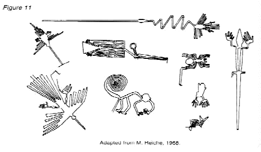
better known of these figures are shown to scale in Figure 11.
The relative sizes of the spider, monkey, condor and lizard
(among others) can be judged against the largest figure - a
stylized heron with a zigzag neck, approximately 900 feet long.
Although the recognizable animal geoglyphs draw most of the attention at Nazca, they are in fact dwarfed by the huge trapezoidal (wedge-like) designs such as the one shown in Plate 12. Some of these wedges have sides more than 2,500 feet long!
The wedges, in turn, are outdone by the lines themselves, which run perfectly straight for up to 5 miles.
What could have been the purpose of all these diverse lines and geoglyphs?
Seen as a whole, the Nazca Lines appear to be a jumbled mess, scattered seemingly at random over the desolate plain, crossing and intersecting for no apparent reason. In some places, carefully drawn geoglyphs have been partly obliterated by the huge wedges.
Furthermore, there is a great contrast between some drawings
which have been perfectly executed, and others which have been
sloppily drawn. More puzzling still, many of the images are so big
that they can only be viewed from the air at a height of 1,000
feet!’" By whom were the lines and figures intended to be seen?
However, his imaginative theory ran into a number of problems.
In addition, von Daniken has failed to explain the
meaning or purpose of the animal geoglyphs.
The strategy of this attack has been to argue that the Nazca Indians constructed the Lines relatively recently - some time between 300 BC and AD 800. In support of this possibility, some scientists have put forward ingenious ideas on how the geoglyphs could theoretically have been designed from the ground.
The more important evidence, however, is that which attempts to link the Lines definitively to the Nazcan culture. Here, neither of the two key pieces of evidence survive close scrutiny. The first piece of evidence is a series of radiocarbon dates, based on ceramic and wood remains which were left at the Lines by the Nazcan people. It is claimed that this proves that the Nazcans constructed the Lines.
On the contrary, the dating of these materials tells us only that the Nazcans lived in the area of the Lines. Since the Lines themselves cannot be radiocarbon dated, the possibility remains that they already existed when the Nazcan culture emerged. The second piece of evidence is the alleged resemblance of the Nazca geoglyphs to certain features found on Nazcan pottery. This is an important issue because it potentially offers proof that the Nazcans had either designed the images or at least viewed them from the air.
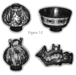
Figure 12 shows four examples of Nazcan pottery exhibited by the museum in the nearby city of Ica. The first supposedly matches the lizard in Figure 11 the second supposedly matches the spider; the third supposedly matches the hummingbird (top left of Figure 11); and the fourth supposedly matches the whale (bottom right of Figure 11).
In all cases the similarities are tenuous and key points of detail from the highly stylized geoglyphs are different or missing on the pottery. Five other examples (not shown below) are equally tenuous. In their eagerness to disprove the von Daniken theory, the experts seem to have forgotten that it is quite normal for ancient artists to reproduce figures of birds, insects, reptiles and sea creatures.
If the judgment of these experts had not been so clouded, they might have wondered why the Nazcans did not decorate their pottery with the more unusual designs of the Nazca plain - the wedge shapes, the intersecting lines and the abstract shapes. How does Maria Reiche explain the purpose of the Nazca Lines?
Although Reiche claims not to have reached a definite conclusion, she leans
heavily towards the theory that they represent an astronomical
calendar. She claims that the Nazcans used the lines and figures to
measure the key points of the solar year to assist with agricultural
planning. However, Reiche’s theory, like von Daniken’s, has
collapsed under the overwhelming weight of logical argument stacked
against it.
In 1982, Anthony Aveni obtained similar results," whilst in 1980, Georg Petersen pointed out that Reiche’s theory did not explain the different lengths and widths of the lines.
More
recently, Johan Reinhard has noted that the surrounding mountains
provided a ready-made and much more effective mechanism for the
Nazcans to use as a solar calendar; the lines would thus have been
quite superfluous to them. In addition to this avalanche of
scientific opinion, we should also note that Reiche, like von
Daniken, has failed to explain the significance of the animal
geoglyphs.
They were certainly not
Inca roads, since many lines begin and end in mid-desert, and they
were certainly not irrigation canals, since most of them do not lead
to sources of water. With all possible practical purposes exhausted,
many writers have begun to focus on the symbolism of the lines and
figures. All manner of religious cults have now been suggested -
ancestor cults, water cults, fertility cults and mountain cults.
These Gods controlled the weather and
hence the water supply which determined the fertility of crops and
livestock. Reinhard added that the chief God Viracocha (mentioned
earlier re: Tiwanaku) was closely associated with both mountains and
water.
As Reinhard explains, this cult theory explains the single most significant aspect of the Nazca Lines:
Could this be a vital clue towards solving the mystery?
The anthropologists attribute the belief in mountain Gods to a sound ecological basis, since mountains are the source of rivers and rain clouds. But what if these mountain Gods were not the product of human imagination? What if they were flesh-and-blood Gods who sometimes flew in aircraft?
It would be premature to reveal my unique proposal for solving the Nazca mystery at this point, but it is necessary for me to make two things quite clear first, I am not saying that the Nazca Lines represented an airfield; secondly, I am saying that they do strongly indicate that aircraft technology was needed to observe them. This might seem a fanciful idea if it were not for the level of high technology seen earlier at Baalbek, Tiwanaku and the various pre-Incan sites of Peru.
A very strong
pattern has emerged in this chapter. All of the sites we have
studied indicate the existence of two distinctly different levels of
culture a prehistoric culture with advanced technology. and a later
culture which gazed in awe at the miraculous stonework which the
advanced culture had left behind. Were all of these sites adopted as
sacred centers by later cultures, who created or preserved the
legends of the Gods?
They did not understand its purpose, but they made it their most hallowed spot. Nazca represents a parallel situation. It may be no coincidence that the Nazcan capital of Cahuachi functioned primarily as a ceremonial centre and is dated to c. AD 200, exactly the same time that Tiwanaku emerged as a sacred centre.
As at Tiwanaku, the Nazcans may have adopted the Lines, nor understanding their origin or purpose, but worshipping them as sacred signs of the Gods. As Johan Reinhard has noted, they built simple religious shrines at the end of many lines and worshipped mountain Gods as their ancestors.
If we take these Gods to be the same flesh-and-blood beings that designed the waterworks of Tiwanaku and Chavin, the fortress of Sacsayhuaman and the platform at Baalbek, then the Nazca Lines signify another very important technology - they tell us that the Gods could fly...
|

 ancient Peru.