|

extracted from 'Signature Of The
Invisible Brotherhood'
The history of the city plan for Washington, D.C. is not quit what
most citizens of the United States might expect. It appears to be
more of a private venture than a public project. Private in more
ways than one.
The newly formed Congress established as one of the newly elected
President’s first duties to chose the location of the city to be the
Capital of the United States. After a location was determined, a new
city would be established for the Nation’s Capital. It was the
responsibility of George Washington to determine the sight for the
Capital.
But, was this location already chosen before the forming of the
United States? Washington,
D.C. is found in the same general geographic location as Jamestown,
the first permanent English settlement in North America. Most
history books tell us that Washington’s location was established as
a compromise between the Southern and Northern States. But, Baron De Graffenried (a Swiss baron) tried to establish a colony at the exact
location of Washington, D.C. as the preferred site for his project.
De Graffenried states,
“I believe that there are scarcely any places
in the world more beautiful and better situated than this of the
Potomac...
There is a very pretty island (Theodore Roosevelt Island) of very
good ground, and facing it,
an angle between the great Potomac River and another little river
named Gold Creek (now
Rock Creek).”
The land on which much of the Capital City is built
today was owned by Ninian Beall, a Scot who owned a 1,503-acre track
called “Inclosure.” Two other tracks called
“Beall’s Levels and the Rock of Dumbarton” make up current day
Washington, D.C. and
Georgetown. Was George Washington continuing a project established
by De Graffenried and Beall 60 years earlier?
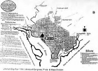
WHERE DOES LENFANT FIT IN?
History tell us that the Frenchman Major Pierre Charles L’Enfant was
the city planner for
Washington, D.C. But, a few books establish the fact that L’Enfant
was really the middleman working from a set of original plans
developed by George Washington and Thomas Jefferson.
Both Washington and L’Enfant had two things in common. First, they
both served in the
War for Independence, L’Enfant being a French volunteer in the Corps
of Engineers. Second, they were both members of the newly formed Society of Cincinnati.
L’Enfant had been asked by Baron von Steuben and members of the
Society of Cincinnati to design the insignia for this exclusive
group. This was the job for someone who understood symbols related to
the principles of the Society. His work so impressed George
Washington,
the president of the Society of Cincinnati; that L’Enfant was asked
to work on several national projects.
Later L’Enfant designed the courthouse in New York, where the first
Congress of the United States held its meetings. History tells us, it
was a combination of his work with the Society of Cincinnati and the
New York Congress building that made George Washington chose
L’Enfant as the designer for the city plan of Washington, D.C. It
appears L’Enfant was handpicked for his ability in the use of
symbolic design, instead of his ability as a city planner.
This is most true when you consider the fact that L’Enfant was not
known as a city planner,
or does it appear he designed any city plans before Washington, D.C.
Based on a letter to L’Enfant, date August 18, 1791, Jefferson
communicated his ideas for the map of the city
directly to L’Enfant. Some historians believe L’Enfant adopted these
ideas and expanded on
them.
THE MISSING NOTES - A COVER-UP?
It is unclear if George Washington, Thomas Jefferson, or Pierre
L’Enfant himself
determined the various symbols that form the streets of Washington,
D.C. Many things
indicate that L’Enfant was just following orders from Washington and
Jefferson. In the book
L’Enfant and Washington, it is pointed out that Washington was
pulling all the strings, since the plans appear to be “orally
conveyed” by Washington to L’Enfant.
The fact that three years of George Washington’s diary has mysteriously disappeared,
prevents us from knowing exactly what sort of communications
occurred between George
Washington and L’Enfant. In addition, correspondence with Jefferson
concerning the
development of the proposed “Plan” have disappeared. The mysterious
disappearance of this historical information concerning both
Washington and Jefferson and their involvement in the
original design of Washington, D.C. wreaks of a cover up - perhaps
the original Watergate.
Is it possible that the missing dairies and correspondence have been
intentionally lost to maintain secrecy about the true nature of the
development of the Nation’s Capital?
It is known that the Secretary of State, Thomas Jefferson, issued
the orders for L’Enfant to design the city and public buildings.
Washington, Jefferson, and L’Enfant met twice weekly, every
Wednesday and Saturday evenings to discuss the “Plan.” Both
Jefferson and Washington felt an affinity with Roman institutions,
law, citizenship, and architecture; so many Roman features like
dooms and columns were adopted to the “Plan.”
Andrew Ellicott was the surveyor who laid out the city and its
streets. He established 40 boundary stones one mile apart, producing
a ten mile square boundary. The center point was fixed by night
observations from a level platform on the hill where the Capital
Building was to be built. Records were kept on the north star and
the moon to establish a line due east and west, another straight
line due north and south, with the center of the Capital dome at the
point of intersection. Ellicott was responsible for finishing the
“Plan” when L’Enfant was fired.
The city that L’Enfant’s original plans proposed for the Capital
City is nothing like the present day Washington. The symbols in the
streets of Washington, D.C. today appear to have evolved from
L’Enfant’s basic design. This basic design did include the layout of
“different shapes” as specified in the written legends that
accompanies the original set of plans. The following is the original
legend for the plans for Washington, D.C.
“OBSERVATIONS EXPLANATORY OF THE PLAN
I. The positions for the different Grand Edifices, and for several
Grand Squares or Areas of different shapes as they are laid down,
were first determined on the most advantageous ground, commanding
the most extensive prospects, and the better susceptible of such
improvements as the various intents of several objects may require.
II. Lines or Avenues of direct communication have been devised, to
connect the separate and most distant objects with the principal,
and to preserve through the whole a reciprocity of sight at the same
time. Attention has been paid to the passing of these leading
avenues over the most favorable ground for prospect and convenience.
III. North and South lines, intersected by other running due East
and West, make the distribution of the city into streets, squares
etc., and those lines have been so combined as to meet at certain
given points with those divergent avenues, so as to form on the
spaces “first determined,” the different Squares or Areas which are
all proportional in magnitude to the number of avenues leading to
them.”
Though the legend does not name or explain the specific shapes or
symbols, it does make
clear that areas of “different shapes” were in the original plans
proposed to L’Enfant by
Washington or Jefferson.
Now take the words from the legend that have been underlined and
think about their meaning. Is it possible another meaning is being
expressed other than the layout of city streets?
When land in the city limits of Washington, D.C. was offered for
sell, property owners
demanded copies of the city plan. L’Enfant refused claiming that if
the maps were made public
before the principal buildings were established, unsightly
structures would be built on the best
locations. This caused the sell of lots to fail, preventing the
government from getting the
needed funds to finish the city on time. The President was forced to
dismiss L’Enfant in 1792, only one year after he had started work on
the city.
In 1812, Secretary of War James Monroe ask L’Enfant to build Fort
Washington south of the city to defend against future British
attacks. Again, his work was incomplete and he was dismissed. He
spent his remaining years as a ground keeper residing at the Chilham Castle Manor, the estate of his benefactor,
William Dudley Digges, at Green Hills, Maryland. He
died on June 14, 1825 and was buried in obscurity until 1909. In
1909 his remains were
moved with military escort to the Capital building, where he laid in
state for three hours.
During that time, thousands of Americans paid their respects to the
man who had planned the
Nation’s Capital City. On noon of that day, he was buried at a
honored vantage point in Arlington National Cemetery. On May 22, 1911
a tombstone that now marks his grave was
dedicated. The tombstone is engraved with a motif of the first map
of L’Enfant’s “Plan.”
Is it possible that L’Enfant had designed something so special in
his city plan that no one of his day could appreciate or understand
it? It is possible that someone around 1900
recognized the value of his work? Placing the body of an architect
who does not finish what he starts, in the Capital Building Rotunda
for public ceremonies eighty-four years after his
death for only three hours, sounds very unusual. According to the
history books, thousands of
people appeared for the public viewing at the Capital.
-
Can thousands
of people really pass in precession through the Rotunda in three
hours?
-
Is something else really taking place in these
ceremonies?
-
If Washington and Jefferson are the real originators of
the design; why is L’Enfant, who was dismissed from the job,
receiving all the credit?
-
Is someone trying to sidetrack us with a
re-write on history?
The Capital Rotunda has a secret of its own. Hidden below the floor
of the Rotunda is a Crypt Room which was originally designed to be
the resting place of George Washington.
You will see a model of the Capital Building on display in this
room. Beneath the center of
the Crypt floor (marked by a star) is the vacant tomb of George
Washington. This is an
American version of Napoleon’s tomb. Washington’s resting place is
at Mt. Vernon, but his remains were nearly moved to the Rotunda in
1832. Space was provided in the construction
of the central section of the Rotunda between 1818-1829 for the tomb
by a joint resolution passed by Congress.
On Feb. 13, 1832 Congress
executed an original resolution to have the
body of Washington moved to the Crypt Room. But, John A. Washington,
grand-nephew of George Washington, refused consent. The bodies of
Kennedy, Lincoln, McKinley, Garfield,
Harding, Taft, Hoover, Wilson, Stevens, Dewey, Pershing, MacArthur,
L’Enfant, and two
unknown soldiers have been placed on the catafalque found in the
tomb.
There is another well-known underground Crypt beneath a dome. It is
the tomb of St. Peter beneath the Basilica at the Vatican.
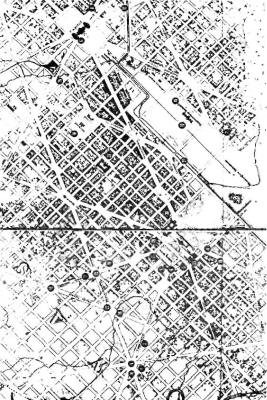
L’Enfant City Plan 1792 , Library of Congress, Photo & Maps Division
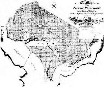
 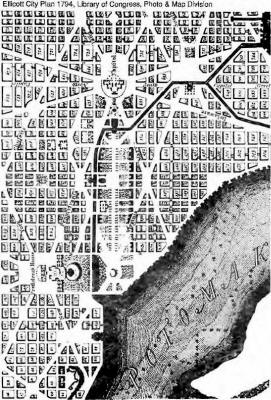
THE CHANGES
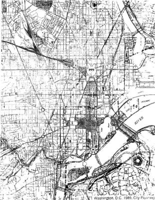
Washington, D.C. will always be a city of constant change. The city
has experienced many changes in the street layout that can be
grouped in stages. Each stage has added new symbols to the original
“Plan.” The next few pages illustrates the changes in the streets of
Washington over the past 200 years.
The L’Enfant-Ellicott stage was started on April 15, 1791 and was
finished in 1799. Congress moved to town the following year. On
Saturday, November 22, 1800 the Congress met for the first time in
Washington at a joint meeting in the Senate Chamber of the
unfinished Capital Building. President Adams made a speech at this
first meeting.
“... it would be unbecoming the representatives of this nation to
assemble for the first time in this solemn temple, without looking
up to the Supreme Ruler of the Universe and Imploring His blessing.”
Why did Adams refer to the Senate wing of the unfinished Capital
building as a “temple?”
THE BATTLE WITH THE BRITISH IN 1814
The attack on Washington, D.C. by the British was the only time the
Capital of United States was invaded since its conception. On August
24, 1814 the British began their destruction that went on through
the night and the next morning. Only the Patent Office was spared
destruction because Dr. Thornton convinced them,
“to burn what would
be useful to all mankind, would be as barbarous as formerly to bum
the Alexandrian Library, for which the Turks have since been
condemned by all enlightened nations.”
But, on August 25 a great storm blew up, putting out the fires and
driving out the invaders.
According to Mary Ingle, thirteen at the time;
“I well remember the terrific tornado which drove the enemy in haste
to their ships, from which [hey were in dread of being cut off...
The sky changed from the peculiar leaden hue portending a wind
storm, into almost midnight blackness. Then came the crash and glare
on incessant thunder and lightning, and the wild beating of the
rain........ Later we encountered a group of British officers taking
a last drink from the old pump.
‘Great God, Madam!’ said Admiral
Cockburn, ‘is this the kind of storm to which you are accustomed in
this infernal country?’ ‘No, sir,’ was the reply; ‘this is a special
interposition of Providence to drive our enemies from the city.’
‘Not so, Madam,’ he answered; ‘it is rather to aid them in
destruction of your city.’
With this parting shot the ‘Red Coats’
galloped off and disappeared forever from the Nation’s Capital.”
The Washington Monument Stage
Washington, D.C. Tour Guide, 1801, Library of Congress
This is the stage of city growth in which the Washington Monument
was started and finished.
The Lincoln Stage
The Senate Park Commission of 1901, lead by Senator James McMillan
of Michigan, further expanded the city’s design by adding to the
west end of L’Enfant’s original plan the Lincoln Memorial and
Jefferson Memorial. The Lincoln Memorial was built on swamp land. It
was completed before the Jefferson Memorial.
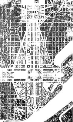
McMillan Plan 1901, Library of Congress
The Jefferson Stage
This is the start of what may be considered to be the current stage
of the city plan for Washington, D.C. The finishing of the Jefferson
Memorial, originally named “Hall of the Founding Fathers,” adds to
the plan by giving it the current symmetrical shape based around L’Enfant’s original “Plan.” This shape not only adds to the
symmetrical layout of the original design, but it adds to the
symbolic meaning of the “Plan.”
The Jefferson Memorial appears to be
borrowed from the original design of the Washington Monument. Most
historians believe it was designed after the Pantheon in Rome.
The original “Plan” by L’Enfant called for five points of interest.
With the completion of the Jefferson Memorial, the Washington
Monument, the Lincoln Memorial, the White House, and the Capital
Building these five points were accomplished. But, it is possible L’Enfant was referring to five other points?
|
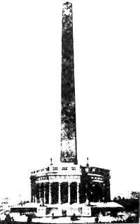
First Design for Washington Monument,
Library of Congress
|
 |
|


