|
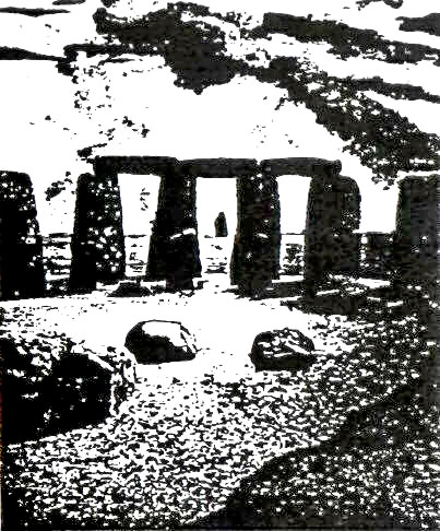
No view epitomizes Stonehenge more than the sight of the Sun's rays shining through the still-standing megaliths of the Sarsen Cirele at sunrise on summer's longest day, when the Sun in its northern migration seems to hesitate, stop, and begin to return.
As fate would have it, only four of those great stone pillars remain upright and connected at the top by the curving lintels, forming three elongated windows through which we, as though we were Stonehenge's long-gone giant builders, can also view - and determine - the beginning of a new annual cycle (Fig. 108).
Figure 108
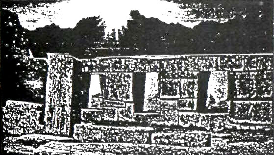
And as fate would have it, somewhere on the other side of the world, another set of three windows in a massive structure of cyclopean stones - built, local lore relates, by giants - also offers a breathtaking view of the Sun appearing through white and misty clouds to direct its rays in a precise alignment.
That other place of the Three Windows, where the Sun also rises on a crucial calendrical day, is in South America, in Peru (Fig. 109).
Figure 109
Is the similarity just a visual fluke, a mere coincidence?
We think not. Nowadays the place is called Machu Picchu, so named after the sharp peak that rises ten thousand feet at a bend of the Urubamba River on which the ancient city is situated. So well hidden in the jungle and among the endless peaks of the Andes, it eluded the Spanish Conquistadors and remained a "lost city of the Incas" until discovered in 1911 by Hiram Bingham.
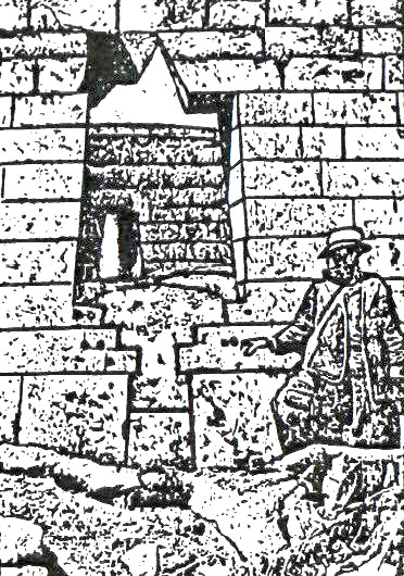
It is now known that it was built long before the Incas, and that its olden name was Tampu-Tocco, "Haven of the Three Windows."
The place, and its unique three windows, are featured in local lore regarding the origins of the Andean civilization when the Gods, led by the great creator Viracocha, placed the four Ayar brothers and their four sister-wives in Tampu-Tocco. Three brothers emerged through the three windows to settle and civilize the Andean lands; one of them founded the Ancient Empire that preceded that of the Incas by thousands of years.
The three windows formed part of a massive wall constructed of cyclopean granite stones that - as at Stonehenge - were not native to the site, but hauled from a great distance across towering mountains and steep valleys. The colossal stones, carefully smoothed and rounded on their surfaces, were cut into numerous sides and angles as though they were soft putty. Each stone's sides and angles fitted the sides and angles of all its adjoining stones; all these polygonal stones thus locked into one another like pieces of a jigsaw puzzle, tightly fitting without any mortar or cement and withstanding the not infrequent earthquakes in the area and other ravages of man and nature.
The Temple of the Three Windows, as Bingham named it. has only three walls: the one with the windows facing in an easterly direction, and two sidewalls as protecting wings. The western side is completely open, providing room for a stone pillar, about seven feet high; supported by two horizontally placed, carefully shaped stones, one on each side, the pillar precisely faces the central window.
Because of a niche cut into the pillar's top, Bingham surmised that it might have held a beam supporting a thatched roofing; but that would have been a unique feature in Machu Picchu, and we believe that the pillar here served the same purpose as the Heel Stone (at first) at Stonehenge or the Altar Stone (later on there), i.e., as the Seventh Pillar of Gudea to provide the line of sight. Ingeniously, the availability of three windows made possible three lines of sight - to sunrise on midsummer day, equinox day, and midwinter day (Fig. 110).
Figure 110
The structure of the three windows with the facing pillar made up the eastern part of what Bingham named, and scholars still call, the Sacred Plaza. Its other principal structure, also three-sided, has its longest wall on the Plaza's northern end and is without a wall on its southern face. It too is made of cyclopean blocks of imported granite also held together by their polygonal shapes. The central north wall has been so constructed as to create seven false windows - trapezoidal cutouts that imitate the three windows but do not in fact cut through the stone wall.
A massive rectangular stone monolith, measuring fourteen by five by three feet, lies on the structure's floor below these false windows. Though the purpose of this structure has not been determined, it is still referred to as the Principal Temple, as Bingham named this structure. Since the five-foot height of the prostrate stone did not let it serve as a seat, Bingham speculated that it might have served as an offering table, "a species of an altar; possibly offerings of food were placed on it, or it may have been intended to receive mummies of the honored dead, which could here be brought out and worshipped on days of festival."
Though such customs are purely imaginary, the suggestion that the structure could have been related to festival days - i.e. to the calendar - is intriguing. The false seven windows have six markedly protruding stone pegs above them, so that some kind of counting involving seven and six - as at the Girsu in Lagash - cannot be ruled out. The two sidewalls contain five false windows each, so that each sidewall - one on the east, one on the west - provided a count of twelve together with the central (northern) wall. This too implies a calendrical function.
A smaller enclosure that belongs to the same Megalithic Age was built as an adjunct to the Principal Temple, behind its northwest corner. It can best be described as a roofless room with a stone bench; Bingham assumed that it was the priest's abode, but there is nothing there to indicate its purpose. What is obvious, though, is that it was built with the greatest care of the same polygonal granite boulders, shaped and polished to perfection. Indeed, it is there that the stone with the most sides and angles - thirty-two! - is found; how and by whom this amazing megalith was carved and emplaced is a mystery that confounds the visitor.
Right behind this enclosure there begins a stairway, made of rectangularly shaped but undressed field stones that serve as steps. It winds its way upward, leading from the Sacred Plaza up a hill which overlooks the whole city. The top of the hill was flattened to enable the construction of an enclosure. It was also built of beautifully shaped and smoothed stones, but not of a megalithic size and not outstandingly polygonal; rather, the higher entrance wall that creates a gateway to the hilltop and the surrounding lower walls are built of ashlars - rectangularly shaped stones that, as bricks, form masonry walls.
This method of construction is neither of a kind with the colossi of the Megalithic Age nor of the obviously inferior structures of field stones, mortared together in their irregular shapes, of which most other structures at Machu Picchu are built. The latter undoubtedly belong to the Inca period; and the ashlar-built structures, as the one on the hilltop, belong to an earlier era which, in The Lost Realms, we have identified as the era of the Ancient Empire.
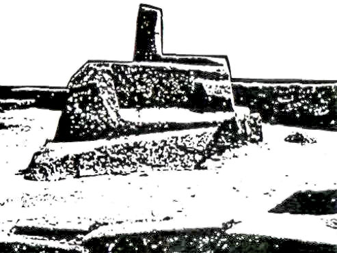
The ashlar-built structure atop the hill was clearly intended only as a decorative-protective enclosure for the main feature of the hilltop. There, in the center, where the hilltop was flattened to form a platform, an outcropping of the native stone was left sticking out, then shaped and carved magnificently to create a polygonal base from which a short stone column projects upward. That the stone-on-a-base served astronomical-calendrical purposes is evident from its name: Intihuatana, which in the local tongue meant "That which binds the Sun."
As the Incas and their descendants explained, it was a stone instrument for observing and determining the solstices, to make sure that the Sun be bound and not keep moving away for good without being pulled back to return (Fig. 111). Nearly a quarter of a century passed between the discovery of Machu Picchu and the first serious study of its astronomical connotations.
Figure 111
It was only in the
1930s that Rolf Miiller, a professor of astronomy at the University
of Potsdam in Germany, began a series of investigations at several
important sites in Peru and Bolivia. Fortunately, he applied to his
findings the principles of archaeoastronomy that were first
expounded by Lockyer; and so, besides the interesting conclusions
regarding the astronomical aspects of Machu Picchu, Cuzco, and
Tiahuanacu (on the southern shores of Lake Titicaca), Miiller was
able to pinpoint their time of construction.
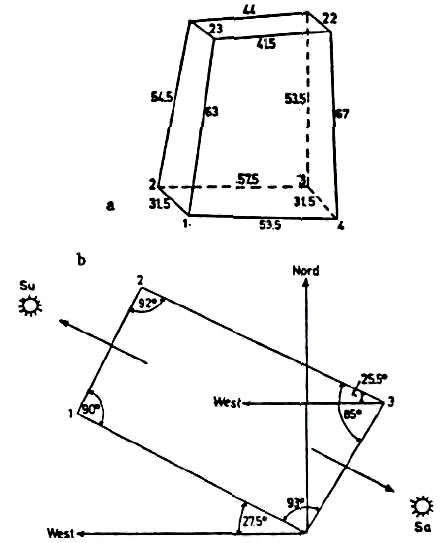
However, the base itself was so shaped and oriented that observations along its grooves could pinpoint sunrise or sunset on crucial days (Fig. 112b). Muller concluded that those preintended days were sunset (Su) on the day of the winter solstice (June 21 in the southern hemisphere) and sunrise (Sa) on the day of the summer solstice (there, December 23).
Figures 112a and 112b
He furthermore determined that the angles of the rectangular base were such that if one were to observe the horizon along a diagonal sightline connecting protrusions 3 and 1, one would have observed sunset precisely on the equinox days at the time the Intihuatana was carved. That, he concluded based on the Earth's greater tilt at the time, was just over four thousand years ago - sometime between 2100 BC. and 2300 BC. This makes the Intihuatana at Machu Picchu contemporaneous with, if not somewhat older than, the Eninnu in Lagash and Stonehenge II.
More remarkable perhaps is the rectangular layout for the astronomical function of the Intihuatana's base, for it imitates the exceptional rectangular layout of the four Station Stones of Stonehenge I (though, apparently, without its lunar purposes). The legend of the Ayar brothers relates that the three brothers from whom the Andean kingdoms stemmed - a kind of South American version of the biblical Ham, Shem, and Japhet- - got rid of the fourth brother by imprisoning him in a cave inside a great rock, where he was turned into a stone.
Such a cave inside a cleft great rock, with a white vertical stem or short pillar inside, indeed exists at Machu Picchu. Above it one of the most remarkable structures in the whole of South America still stands. Built of the same kind of ashlars as on the platform of the Intihuatana, and thus clearly contemporaneous with it, is an enclosure which on two sides forms perfect walls at a right angle to each other, and on the other two sides curves to form a perfect semicircle (Fig. 113a).
It is known the Torreon (the Tower). The enclosure, which is reached by seven stone steps, encompasses, as at the Intihuatana, the protruding peak of the great rock on which it was constructed. As with the Intihuatana, the outcropping here was also carved and given a purposeful shape; except that here no stem was made to act as a gnomon. Instead, the astronomical sightlines that run along grooves and polygonal surfaces of the "sacred rock" lead to two windows in the semicircular wall.
Muller, and other astronomers after him (e.g., D.S. Dearborn and R.E. White, Archaeoastronomy at Machu Picchu), concluded that the sightlines were oriented to sunrises on the days of the winter and summer solstices - more than four thousand years ago (Fig. 113b). The two windows were similar in their trapezoid shape (wider at the bottom, narrower at the top) to the legendary Three Windows in the Sacred Plaza and thus emulated, in shape and purpose, the ones from the Megalithic Age.
Figures 113a and 113b
The similarity continued in that the structure of perfect ashlars, where the semicircle ended and the northerly straight wail began, had a third window - if one can so call the aperture. It is larger than the other two; its sill is not straight, but is shaped as an inverted stairway; and its top is formed not by a straight lintel stone but by a wedge-like slit, like an inverted V (Fig. 114). Because the view through this opening (from inside the Torreon outward) is obstructed by fieldstone buildings from Inca times, the astronomers who had studied the Torreon attached no astronomical significance to this Third Window.
Figure 114
Bingham pointed out that the wall at this window showed clear evidence of fire, and he surmised that it was evidence of the burning of sacrifices on certain festival dates. Our own studies show that when the Incan buildings were not yet there, i.e., at the time of the Ancient Empire, a sightline from the Sacred Rock through the slit in this window to the Intihuatana atop the hill to the northwest would probably have indicated winter solstice sunset when the Torreon was built.
The structure atop the cleft rock also emulated those in the Sacred Plaza in other features. In addition to the three apertures, there were nine false trapezoidal windows in the straight parts of the enclosing walls (see Fig. 113). Spaced between these false windows there protrude from the walls stone pegs or "bobbins" as Bingham called them (Fig. 115).
Figure 115
The longer wall, which has seven false windows, has six such pegs - duplicating the arrangement in the longer wall of the Principal Temple. The number of the windows - actual plus false - twelve, undoubtedly denotes calendrical functions, such as the count of twelve months in a year. The number of false windows (seven) and pegs (six) in the longer wall, as in that of the Principal Temple, may indicate a calendrical need to engage in intercalation - a periodic adjustment of the lunar cycle to the solar cycle by adding a thirteenth month every few years.
Combined with the alignments and apertures for observing and
determining the solstices and the equinoxes, the false windows with
their pegs lead to the conclusion that at Machu Picchu someone had
created a complex solar-lunar stone computer to serve as a calendar.
Long before them one of the Ayar brothers, Manco Capac, founded the city when a golden rod given him by the God Viracocha sank into the ground to indicate the right location. It happened, by the calculations of Montesinos, circa 2400 BC. - almost 3,500 years before the Incas. That Ancient Empire lasted nearly 2,500 years until a succession of plagues, earthquakes, and other calamities caused the people to leave Cuzco.
The king, accompanied by a handful of chosen people, retreated to the hideout of Tampu-Tocco; there, the interregnum lasted about a thousand years, until a young man of noble birth was chosen to lead the people back to Cuzco and establish a New Kingdom - that of the Inca dynasty. When the Spanish conquerors arrived in Cuzco, the Inca capital, in 1533, they were astounded to discover a metropolis with some 100,000 dwelling houses surrounding a royal-religious center of magnificent palaces, temples, plazas, gardens, marketplaces, parade grounds.
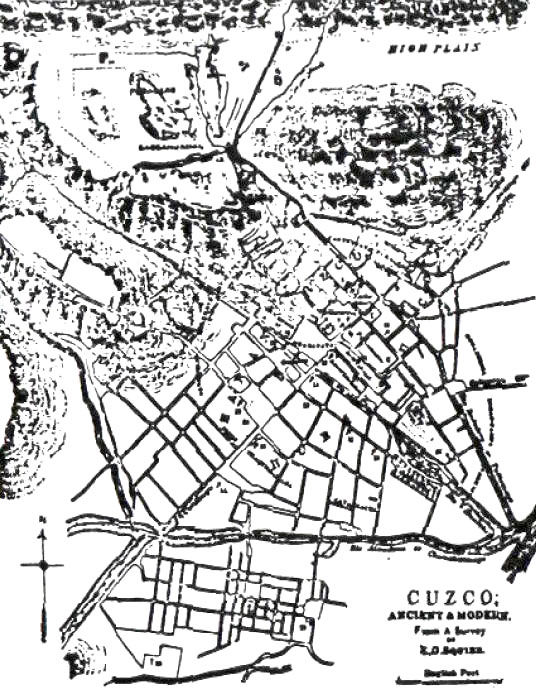
They were puzzled to hear that the city was divided into twelve wards, arranged in an oval, whose boundaries ran along sightlines anchored to observation towers built on peaks encircling the city (Fig. 116). And they were awed by the sight of the city's and empire's holiest temple - not because it was superbly built, but because it was literally covered with gold.
Figure 116
True to its name Coricancha, meaning Golden Enclosure, the temple's walls were covered with plates of gold; inside there were wondrous artifacts and sculptures of birds and animals made of gold, silver, and precious stones; and in the temple's main courtyard there was a garden whose corn and other growths were all artificial, made of gold and silver. The initial scouting party of Spaniards alone removed seven hundred of those gold plates (as well as many of the other precious artifacts).
Chroniclers who had seen the Coricancha before it was vandalized, demolished by the Catholic priests, and built over into a church, reported that the enclosed compound included a main temple, dedicated to the God Viracocha; and shrines or chapels for the worship of the Moon, Venus, a mysterious star called Coyllor, the Rainbow, and the God of Thunder and Lightning.
The Spaniards nevertheless called the temple Temple of the Sun, believing that the Sun was the supreme deity wcrshiped by the Incas. It is assumed that the idea came to the Spaniards from the fact that in the Holy of Holies of the Coricancha - a semicircular chamber - there hung on the wall above the great altar an "image of the Sun." It was a great golden disk which the Spaniards assumed to represent the Sun.
In reality, it had served in earlier times to reflect a beam of light as the Sun's rays penetrated the dark chamber once a year - at the moment of sunrise on the day of the winter solstice. Significantly, the arrangement was akin to that in the Great Temple of Amon at Kamak, in Egypt. Significantly, the Holy of Holies was in the same extremely rare form of a semicircle, as the Torreon in Machu-Picchu.
Significantly, the earliest part of the temple, including the Holy of Holies, was built of the same perfect ashlars as the Torreon and the walls enclosing the Intihuatana - the hallmark of the Ancient Empire era. And, not surprisingly, careful studies and measurements by Muller showed that the orientation designed to permit the beam of sunlight to travel through the corridor and bounce off the "image of the Sun" was conceived when the Earth's obliquity was 24° (Fig. 117), which chronologically means, he wrote, more than four thousand years earlier.
Figure 117
This
matches the timetable related by Montesinos, according to which the
Ancient Empire began circa 25002400 BC. and the assertion that
the temple in Cuzco was built soon thereafter. As astoundingly early
as the structures of the Ancient Empire were, they were clearly not
the earliest ones, for according to the Ayar legends the megalithic
Three Windows had already existed when the founder of the Ancient
Empire, Manco Capac, and his brothers set out from Tampu-Tocco to
establish kingships in the Andean lands.
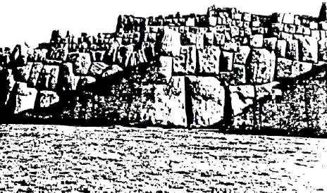
But as mind-boggling as that age's structures at Machu Picchu are, they are neither the largest nor the most enigmatic ones. The prize for that should undoubtedly go to the ruins at Sacsahuaman, the promontory that overlooks Cuzco. Shaped like a triangle with its base toward the mountain chain of which the promontory is an edge, its two sides formed by deep gorges, its apex forms a peak that rises steeply some eight hundred feet above the city that lies at its bottom.
The promontory can be divided into three parts. The widest part, forming the triangle's base, is dominated by huge rock outcroppings that someone - "giants" ac-cording to local lore - had cut and shaped, with incredible ease and at angles that could not possibly have been formed with crude hand tools, to form giant steps or platforms or inverted stairs, additionally perforating the rocks with twisting channels, tunnels, grooves, and niches.
The promontory's middle section is formed by an area hundreds of feet wide and long that has been flattened out to form a huge level area. This flattened-out area is clearly separated from the triangular and more elevated apex of the promontory by a most remarkable and certainly unique stone structure. It consists of three massive walls that extend in a zigzag parallel to each other from one edge of the promontory to the other (Fig. 118).
Figure 118
The walls are built so as to rise one behind the other, to a combined height of about sixty feet. They are constructed of the colossal stone blocks and in the polygonal fashion that is the earmark of the Megalithic Age; those in the forefront, that support the earthfills that form the raised terraces for the second and third tiers, are the most massive. Its smallest boulders weigh between ten and twenty tons; most are fifteen feet high and are ten to fourteen feet in width and thickness. Many are much larger; one boulder in the front row is twenty-seven feet high and weighs over three hundred tons (Fig. 119).
Figure 119
As with the other megaliths at Machu Picchu, the ones at Sacsahuaman too were brought over from a great distance, were given their smooth and beveled faces and polygonal shapes, and remain holding fast together without mortar.
By whom, when, and why were these structures above ground, and the tunnels, channels, conduits, bored holes, and other odd shapes carved into the living rocks, made and fashioned? Local lore attributed it to "the giants." The Spaniards, as the chronicler Garcilaso de la Vega wrote, believed that they were "erected not by men but by demons."
Squier wrote that the zigzagging walls represented "without doubt the grandest specimens of the style called Cyclopean extant in America," but offered no explanation or theory. Recent excavations have uncovered behind the large rock outcroppings that separate the flat middle area from the rocky area leading to the northwest, where most of the tunnels and channels have been formed, one of the most unusual structural shapes in South America: a perfect circle. Carefully shaped stones have been laid out so as to form the rim of a sunken area, perfectly circular.
In The Lost Realms we enumerate the reasons for our conclusion that it served as a reservoir where ores - gold ores, to be specific were processed as in a giant pan. This, however, was not the only circular structure on the promontory. Assuming that the three tiers of colossal walls were ramparts of a fortress, the Spaniards took it for granted that structural remains in the highest and narrowest part of the promontory, behind and above the walls, belonged to an Inca fortification. Prompted by local legends that a child once fell into a hole there and later emerged eight hundred feet down in Cuzco proper, local archaeologists engaged in limited excavations.
They discovered that the area behind and above the three walls was honeycombed with subterranean tunnels and chambers. More important, they uncovered there the foundations of a series of connected square and rectangular buildings (Fig. 120a); in their midst there were the remains of a perfectly circular structure. The natives refer to the structure as the Muyocmarca, "The Circular Building"; the archeologists call it the Torreon - the Tower - the same descriptive name given to the semicircular structure at Machu Picchu, and assumed that it was a defensive tower, part of the Sacsahuaman "fortress." Archaeoastronomers, however, see in the structure clear evidence of an astronomical function.
Figures 120a and 120b
R.T. Zuidema (Inca Observations of the Solar and Lunar Passages, and other studies) noted that the alignment of the straight walls adjoining the circular structure was such that the north and south points of zenith and nadir could have been determined there. The walls that form the square enclosure within which the circular structure was emplaced are indeed aligned with the cardinal points (Fig. 120b); but they form only a frame for the circular structure, which consisted of three concentric walls connected by spokes of masonry that divide the outer two circular walls into sections.
One such opening - an aperture if the higher courses forming the tower followed the ground
plan - does point due south and thus could have served to determine
sunset on nadir day. But the four other openings are clearly
oriented to the northeast, southeast, southwest, and northwest - the
unmistakable points of sunset and sunrise on the winter and summer
solstice days (in the southern hemisphere).
The evidence suggests, however, that after the Megalithic Age and in the era of the Ancient Empire begun under the aegis of Viracocha, both the equinoxes and the lunar cycle played the key roles in the Andean calendar. The chronicler Garcilaso de la Vega, describing the towerlike structures (see Fig. 116) around Cuzco, stated that they were used to determine the solstices.
But he also described another "calendar in stone" that has not survived and that brings to mind the stone circle that stood on the platform in Lagash... According to Garcilaso, the pillars erected in Cuzco served to determine the equinoxes, not the solstices. These are his exact words:
According to the authoritative study The Andean Cal-endar by L.E. Valcarcel, such a fixing and veneration of the equinoxes was carried into Inca times although they switched from an earlier equinoctial calendar to a solstitial one. His study brought out the fact that Inca month names accorded special significance to months corresponding to our March and September, the equinoctial months.
The need to adjust the solar calendar over a period of millennia because of the phenomenon of precession and, Where the Sun Also Rises 243 perhaps, also due to the wavering between a solstitial and an equinoctial New Year, led to repeated reforms of the calendar even in the days of the Ancient Empire. According to Montesinos, the 5th, 22nd, 33rd, 39th, and 50th monarchs of the Ancient Empire "renewed the computation of time that had fallen into confusion."
That such calendar reforms had to do with wavering between solstices and equinoxes is confirmed by the statement that the monarch Manco Capac IV "ordered that the year begin at the spring equinox," a feat possible because he was an Amauta, a "knower of astronomy."
But evidently in doing so he only reinstated a calendar that had once been in use, in earlier times; for, according to Montesinos, the fortieth monarch who had reigned a thousand years before Manco Capac IV,
As if all that was not enough to require constant reforms, other evidence also indicates the employment of, or at least familiarity with, the lunar calendar. In his studies of Andean archaeoastronomy Rolf Muller reported that at a site called Pampa de Anta, some ten miles west of Sacsahuaman, the sheer rock has been carved into a series of steps that form a semicircle or crescent.
Since there is nothing to view there except the promontory at Sacsahuaman to the east, Muller concluded that the place served to make astronomical observations along a sightline anchored on the Sacsahuaman promontory - but, apparently, linked to appearances of the Moon. The native name for the edifice, Quillarumi, "Moon Stone," suggests such a purpose. Shackled by the notions that the Incas worshiped the Sun, modem scholars found it at first difficult to concede that Inca observations could have also included the Moon.
In fact the early Spanish chroniclers stated repeatedly that the Incas had an elaborate and precise calendar incorporating both solar and lunar aspects. The chronicler Felipe Guaman Poma de Avila stated that the Incas "knew the cycles of the Sun and the Moon . .. and the month of the year and the four winds of the world." The assertion that the Incas observed both solar and lunar cycles is confirmed by the fact that next to the shrine to the Sun in the Coricancha there was a shrine to the Moon.
In the Holy of Holies the central symbol was an ellipse
flanked by the Sun on the left and the Moon on the right; it was
only the ruler Huascar, one of the two half brothers who were
fighting over the throne when the Spaniards arrived, who replaced
the oval with a golden disk representing the Sun. These are
Mesopotamian calendrical features; finding them in the remote Andes
has baffled the scholars. Even more perplexing has been the
certainty that the Incas were familiar with the zodiac - a wholly
arbitrary device for dividing the orbital circle around the Sun
into twelve parts - a Sumerian "first" by all accounts.
Figure 121
Sir Clemens Markham (Cuzco and Lima: the Incas of Peru) quoted the chronicler Garcilaso de la Vega's information that the twelve wards represented the twelve zodiacal constellations. Stansbury Hagar (Cuzco, the Celestial City) noted that, according to Inca lore, Cuzco was laid out in conformity with a sacred or divine plan to emulate the heavens, and concluded that the first ward, named "Terrace of Kneeling," represented the constellation Aries.
He showed that - as in Mesopotamia - the Incas also associated each of the twelve zodiac "houses" with a parallel month in the calendar. These zodiacal months bore names that had an uncanny resemblance to their Near Eastern names that originated in Sumer. Thus, the month of the autumn equinox, which equaled the month of the spring equinox and the constellation of the Bull (Taurus) when the calendar began in Sumer, was called Tupa Taruca, "Pasturing Stag."
The constellation of the Maiden (Virgo), as another example, was called Sara Mama, "Mother Maize." To grasp fully the extent of such similarities, one should recall that in Mesopotamia this constellation (see Fig. 91) was depicted as a maiden holding a stalk of grain - wheat or barley in Mesopotamia, replaced by maiz (corn) in the Andes. Hagar's conclusion that the zodiacal layout in Cuzco associated the first ward with Aries rather than with Taurus as in Sumer, suggests that the city's plan was devised after the Age of Taurus had ended (due to precession) at about 2150 BC.
According to Montesinos, it was the fifth ruler of the Ancient Empire who completed the Concancha and introduced a new calendar some time after 1900 BC. That Capac (ruler) was given the epithet Pachacuti (Reformer), and one can safely conclude that the reform of the calendar in his time was required by the zodiacal shift from Taurus to Aries - another confirmation of familiarity with the zodiac and its calendrical aspects even in pre-Inca times in the Andes. There were other aspects - complex aspects - of the ancient Near Eastern calendars in the calendar that the Incas had retained from the days of the Ancient Empire.
The requirement (still in force in the Jewish and Christian calendars) that the spring festival (Passover, Easter) be held when the Sun is in the relevant zodiac house and on or immediately after the first full Moon of that month, forced the ancient priest-astronomers to intercalate the solar and lunar cycles.
The studies by R.T. Zuidema and others concluded that not only did such intercalation take place in the Andes, but that the lunar cycle was additionally linked to two other phenomena: it had to be the first full Moon after the June solstice, and it was to coincide with the first heliacal rising of a certain star. This double correlation is intriguing, for it brings to mind the Egyptian linking of the beginning of their calendrical cycle both to the solar date (rising of the Nile) and the heliacal rising of a star (Sinus).
Some twenty miles northeast of Cuzco, at a place called Pisac, there are remains of a structure, probably from early Inca times, that appear to have been an attempt to emulate and combine some of the sacred structures at Machu Picchu: a building one of whose sides was semicircular, with a crude Intihuatana in its midst. At a place not far from Sacsahuaman called Kenko, a large semicircle of well-shaped ashlars fronts on a large stone monolith that could have had the shape of an animal (the features are too damaged to be discerned); whether or not this edifice had astronomicalcalendrical functions is unknown.
These sites, added to those of Machu Picchu, Sacsahuaman, and Cuzco, illustrate the fact that in what has been called the Sacred Valley - and only there - religion, the calendar, and astronomy led to the construction of circular or semicircular observatories; nowhere else in South America do we find such structures.
Who was it who, at about the same time, applied the same set of astronomical principles and adopted a circular shape for celestial observations in early Britain, at Lagash in Sumer, and in South America's Ancient Empire? All legends, supported by geographical evidence and ar-chaeological finds, point to the southern shores of Lake Titicaca as the place of the South American Beginning - not only of human civilization, but of the Gods themselves.
It was there, according to the legends, that the repopulation of the Andean lands began after the Deluge; that the Gods, headed by Viracocha, had their abode; that the couples destined to begin the Ancient Empire were given knowledge, route instructions, and the Golden Wand with which to locate the site of the Navel of the Earth - of establishing Cuzco.
Insofar as human beginnings in the Andes are concerned, the tales connected them to two distinct islands off the southern shore of Lake Titicaca. They were called the Island of the Sun and the Island of the Moon, the two luminaries having been considered as the two principal helpers of Vir-acocha; the calendrical symbolism inherent in these tales has been noted by many scholars. The abode of Viracocha was, however, in a City of the Gods on the mainland, at the lake's southern shore.
The place, called Tiahuanacu, was settled by the Gods (according to local lore) in times immemorial; it was, the legends related, a place of colossal structures that only giants could erect. The chronicler Pedro Cieza de Leon, who traveled throughout what is now Peru and Bolivia in the years immediately following the Spanish conquest, reported that without doubt, of all the antiquities in the Andean lands, the ruins at Tiahuanacu were "the most ancient place of any."
Among the edifices that amazed him was an artificial hill "on a great stone foundation" that measured more than 900 feet by 400 feet at its base and rose some 120 feet. Nearby he saw gigantic stone blocks fallen to the ground, among them "many doorways with their jambs, lintels, and thresholds all in one stone" which in turn were part of even larger stone blocks, "some of them thirty feet broad, fifteen or more long, and six in thickness."
He wondered whether "human force can have sufficed to move them to the place where we see them, being so large." But not only the immense size of the stone blocks puzzled him; so did their "grandeur and magnificence." "For myself," he wrote, "I fail to understand with what instruments or tools it could have been done, for it is certain that before these great stones could be brought to perfection and left as we see them, the tools must have been much better than those now used by the Indians."
He had no doubt that "two stone idols, of the human shape and figure, the features very skillfully carved... that seem like small giants" were responsible for the wondrous structures. Over the centuries most of the smaller stone blocks have been carted away to be used in La Paz, the Bolivian capital, in railroads leading to it, and in rural areas all around.
But even so, travelers continued to report the incredible monumental remains; by the end of the nineteenth century the reports assumed a more scientific accuracy as a result of the visits and researches by Ephraim George Squier (Peru: In cidents of Travel and Exploration in the Land of the Incas) and A. Stubel and Max Uhle (Die Ruinenstaette von Tia-huanaco im Hochland des Alten Peru).
They were followed earlier this century by the most renowned and tenacious researcher of Tiahuanacu, Arthur Posnansky (Tiahuanacu - The Cradle of American Man). Their work and more recent excavations and studies, reviewed at length in The Lost Realms, have led us to conclude that Tiahuanacu was the tin capital of the ancient world, that its extensive above-ground and underground structures were metallurgical facilities, that the huge one-piece multi-walled stone blocks were part of port facilities at the ancient lakeshore, and that Tiahuanacu was founded not by Man but by the Anunnaki "Gods" in their search for gold long before Man was taught the uses of tin. Where a narrow and rare plain fanned out from the southern shore of Lake Titicaca, the site of the once magnificent Tiahuanacu and its port (nowadays called Puma-Punku), only three principal monuments to its past dominate the landscape.
The one at
the southeastern part of the ruins is the hill called Akapana, an
artificial hill (as Cieza de Leon had observed) that was assumed to
have served as a fortress; it is now known to have been more like a
stage-pyramid with built-in reservoirs, conduits, channels and
sluices that indicate its true purpose: a facility for the
separation and processing of ores.
It is indeed a gate, intricately cut and carved out of a single cyclopean stone block; but it was not set up to commemorate a victory - rather, to enshrine in stone a marvelous calendar. Called "Gate of the Sun," the single stone block from which it was cut and shaped measured about ten by twenty feet and weighed more than one hundred tons. There are niches and geometrically accurate cutouts upon the lower part of the gate, especially on what is considered its back side (Fig. 122b). The most elaborate and enigmatic carvings are on the upper front side (Fig. 122a), facing due east.
Figures 122a and 122b
There, the arch of the gate has been carved to depict in relief a central figure - probably of Viracocha - flanked on each side by three rows of winged attendants (Fig. 123a); the central figure and three rows have been positioned above a meandering geometric frame so carved as to snake over and under miniature images of Viracocha (Fig. 123b).
Figures 123a and 123b
The writings of Posnansky have established that the carvings on the gate represented a twelve-month calendar of a year beginning on the day of the spring equinox in the southern hemisphere (September), yet a year where the other major points of the solar year - the autumn equinox and the two solstices - are also indicated by the positions and shapes of the depicted smaller images.
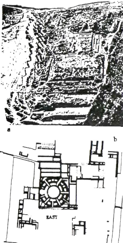
It was, he concluded, a calendar of eleven months of thirty days each plus a "great month,'1 a twelfth month of thirty-rive days, adding up to a solar year of 365 days. A twelve-month year beginning on the day of the spring equinox was, as we now know, first introduced at Nippur, in Sumer, circa 3800 BC. The "Gate of the Sun," archaeologists have discovered, stands at the northwest corner of what was a wall constructed of upright stone pillars that formed a rectangular enclosure within which the third most prominent edifice of the site stood.
Some believe that there was originally a similar gate at the southwestern corner of the enclosure, flanking symmetrically a row of thirteen monoliths erected in the precise center of the enclosure's western wall. That row of monoliths, part of a special platform, faced exactly the monumental stairway that was built at the center of the eastern wall, on the enclosure's opposite side. The monumental stairway, which has been unearthed and restored, led to a series of raised rectangular platforms that encompassed a sunken courtyard (Fig. 124a).
Figures 124a and 124b
Given the name Kalasasaya ("The Standing Pillars"), the edifice was thus oriented precisely along an east-west axis, in the manner of the Near Eastern temples. This was the first clue that it could have served astronomical purposes. Subsequent researches indeed established that it was a sophisticated observatory for determining the solstices as well as the equinoxes by observing sunrises and sunsets from certain focal points along sightlines anchored at the enclosure's corners and the pillars erected at its western and eastern walls (Fig. 124b).
Posnansky found evidence that the back side of the Gate of the Sun was so carved out that it probably held two golden panels that could be swung on bronze axles; that might have enabled the astronomer-priests to angle the plates so that they reflected the sunset rays toward any desired observation post in the Kalasasaya proper.
The multiple sightlines, more than were required just for observations on solstice or equinox days, the fact that Viracocha was helped by both the Sun and the Moon, and the fact that there were thirteen, not just twelve, pillars at the center of the western wall suggest that the Kalasasaya was not just a solar observatory, but one that served a solarlunar calendar.
The realization that this ancient structure, more than twenty thousand feet up the Andean mountains, in a desolate, narrow plain among snowbound mountains, was a sophisticated calendrical observatory was compounded by discoveries regarding its age. Posnansky was the first to conclude that the angles formed by the lines of sight suggested an obliquity somewhat greater than the present declination of 23.5°; it meant, he himself was astounded to realize, that the Kalasasaya had been designed and built thousands of years before the Common Era.
The understandable disbelief on the part of the scientific community at the time - at most it was thought the ruins, Where the Sun Also Rises 253 if not from Incan times, were not older than from a few centuries BC. - led to the dispatch of a German Astronomical Commission to Peru and Bolivia. Dr. Rolf Muller, whose extensive work on other sites has already been mentioned by us, was one of the three astronomers chosen for the task.
The investigations and thorough measurements left no doubt that the obliquity prevailing at the time of construction was such that the Kalasasaya could have been built circa 4050 BC. or (as the Earth tilted back and forth) circa 10,050 BC. Muller, who had arrived at a date of just over 4000 BC. for the megalithic remains at Machu Picchu, was inclined likewise to date the Kalasasaya - a conclusion with which Posnansky in the end agreed.
Who was there with such sophisticated knowledge to plan, orient, and erect such calendrical observatories - and in a manner that followed the astronomical principles and calendrical arrangements devised in the ancient Near East? In The Lost Realms we presented the evidence and arrived at the conclusion that it was the same Anunnaki. those who had come to Earth from Nibiru in need of gold.
And, like the men who searched for the golden El Dorado millennia later, they also came to the New World in search of gold. The mines in southeastern Africa were flooded by the Deluge; but the same upheaval uncovered the incredibly rich veins of gold in the Andes. We believe that Anu and his spouse Antu, visiting Earth from Nibiru circa 3800 BC., also went to see for themselves the new metallurgical center on the southern shore of Lake Titicaca.
They left by sailing away on the lake from the port facilities of Puma Punku, where the cyclopean chambers, carved and shaped out of single stone blocks, then stood alongside massive piers. The remains at Puma Punku hold another enigmatic clue to the amazing link between the structures at Lake Titicaca and the unusual temple to Ninurta that Gudea built. To the disbelief of the site's excavators, they found that the megalithic builders had used bronze clamps, formed to fit T-shaped cutouts in adjoining stones, to hold together the huge stone blocks (Fig. 125).
Figure 125
Such a clamping method, and such a use of bronze, were unique to the Megalithic Age, having been found only at Puma Punku and at another site of cy-clopean megaliths, Ollantaytambu, some forty-five miles northwest of Cuzco in the Sacred Valley. Yet thousands of miles away, on the other side of the world, at Lagash in Sumer, Gudea used the very same unique method and the very same unique bronze clamps to hold together the stones that, imported from afar, were used in the construction of the Eninnu.
Recording in his inscriptions the unusual use of stones and of metals, this is how Gudea lauded his own achievements:
It was a feat for which a Sangu Simug, a "priestly smith," was brought over from the "Land of Smelting." It was, we believe, Tiahuanacu in the Andes.
|