|
CITIES OF THE
GODS
THE STORY of the first settlement of Earth by intelligent beings is
a breathtaking saga no less inspiring than the discovery of America
or the circumnavigation of Earth.
It was certainly of greater
importance, for, as a result of this settlement, we and our
civilizations exist today.
The "Epic of Creation" informs us that the "gods" came to Earth
following a deliberate decision by their leader. The Babylonian
version, attributing the decision to Marduk, explains that he waited
until Earth's soil dried and hardened sufficiently to permit landing
and construction operations.
Then Marduk announced his decision to
the group of astronauts:
In the deep Above,
where you have been residing,
"The Kingly House of Above" have I built.
Now, a counterpart of it
I shall build in The Below.
Marduk then explained his purpose:
When from the Heavens
for assembly you shall descend,
there shall be a restplace for the night
to receive you all.
I will name it "Babylon" -
The Gateway of the Gods.
Earth was thus not merely the object of a visit or a quick,
exploratory stay; it was to be a permanent "home away from home."
Traveling on board a planet that was itself a kind of spaceship,
crossing the paths of most of the other planets, the Nefilim no
doubt first scanned the heavens from the surface of their own
planet. Unmanned probes must have followed. Sooner or later they
acquired the capacity to send out manned missions to the other
planets.
As the Nefilim searched for an additional "home," Earth must have
struck them favorably. Its blue hues indicated it had
life-sustaining water and air; its browns disclosed firm land; its
greens, vegetation and the basis for animal life. Yet when the
Nefilim finally voyaged to Earth, it must have looked somewhat
different from the way it does to our astronauts today.
For when the Nefilim first came to Earth, Earth was in the midst of an ice age -
a glacial period that was one of the icing and deicing phases of
Earth's climate:
Early glaciation - begun some 600,000 years ago First warming
(interglacial period) - 550,000 years
ago Second glacial period - 480,000 to 430,000 years ago
When the Nefilim first landed on Earth some 450,000 years ago, about
a third of Earth's land area was covered with ice sheets and
glaciers. With so much of Earth's waters frozen, rainfall was
reduced, but not everywhere. Due to the peculiarities of wind
patterns and terrain, among other things, some areas that are well
watered today were barren then, and some areas with only seasonal
rains now were experiencing year-round rainfalls then.
The sea levels were also lower because so much water had been
captured as ice on the land masses. Evidence indicates that at the
height of the two major ice ages, sea levels were as much as 600 to
700 feet lower than at present. Therefore, there was dry land where
we now have seas and coastlines. Where rivers continued to run, they
created deep gorges and canyons if their courses took them through
rocky terrain; if their courses ran in soft earth and clay, they
reached the ice-age seas through vast marshlands.
Arriving on Earth amidst such climatic and geographic conditions,
where were the Nefilim to set up their first abode?
They searched, no doubt, for a place with a relatively temperate
climate, where simple shelters would suffice and where they could
move about in light working clothes rather than in heavily insulated
suits. They must also have searched for water for drinking, washing,
and industrial purposes, as well as to sustain the plant and animal
life needed for food. Rivers would both facilitate the irrigation of
large tracts of land and provide a convenient means of
transportation.
Only a rather narrow temperate zone on Earth could meet all these
requirements, as well as the need for the long, flat areas suitable
for landings. The attention of the Nefilim, as we now know, focused
on three major river systems and their plains: the Nile, the Indus,
and the Tigris-Euphrates. Each of these river basins was suitable
for early colonization; each, in time, became the center of an
ancient civilization.
The Nefilim would hardly have ignored another need: a source of fuel
and energy. On Earth, petroleum has been a versatile and abundant
source of energy, heat, and light, as well as a vital raw material
from which countless essential goods are made. The Nefilim, judging
by Sumerian practice and records, made extensive use of petroleum
and its derivatives; it stands to reason that in their search for
the most suitable habitat on Earth, the Nefilim would prefer a site
rich in petroleum.
With this in mind, the Nefilim probably placed the Indus plain in
last place, for it is not an area where oil could be found. The Nile
valley was probably given second place; geologically it lies in a
major sedimentary rock zone, but the area's oil is found only at
some distance from the valley und requires deep drilling.
The Land
of the Two Rivers, Mesopotamia, was doubtless put in first place.
Some of the world's richest oil fields stretch from the tip of the
Persian Gulf to the mountains where the Tigris and Euphrates
originate. And while in most places one must drill deep to bring up
the crude oil, in ancient Sumer (now southern Iraq), bitumens, tars,
pitches, and asphalts bubbled or (lowed up to the surface naturally.
(Interestingly, the Sumerians had names for all bituminous
substances - petroleum, crude oils, native asphalts, rock asphalts,
tars, pyrogenic asphalts, mastics, waxes, and pitches. They had nine
different names for the various bitumens. By comparison, the ancient
Egyptian language had only two, and Sanskrit, only three.)
The Book of Genesis describes God's abode on Earth - Eden - as a
place of temperate climate, warm yet breezy, for God took afternoon
strolls to catch the cooling breeze. It was a place of good soil,
lending itself to agriculture and horticulture, especially the
cultivation of orchards. It was a place that drew its waters from a
network of four rivers. "And the name of the third river [was]
Hidekel [Tigris]; it is the one which floweth towards the east of
Assyria; and the fourth was the Euphrates."
While opinions regarding the identity of the first two rivers,
Pishon ("abundant") and Gihon ("which gushes forth"), are
inconclusive, there is no uncertainty regarding the other two
rivers, the Tigris and the Euphrates. Some scholars locate Eden in
northern Mesopotamia, where the two rivers and two lesser
tributaries originate; others (such as E. A. Speiser, in The Rivers
of Paradise) believe that the four streams converged at the head of
the Persian Gulf, so that Eden was not in northern but in southern
Mesopotamia.
The biblical name Eden is of Mesopotamian origin, stemming from the
Akkadian edinu, meaning "plain." We recall that the "divine" title
of the ancient gods was DIN.GIR ("the righteous/just ones of the
rockets"). A Sumerian name for the gods' abode, E.DIN, would have
meant "home of the righteous ones" - a fitting description.
The selection of Mesopotamia as the home on Earth was probably
motivated by at least one other important consideration. Though the
Nefilim in time established a spaceport on dry land, some evidence
suggests that at least initially they landed by splashing down into
the sea in a hermetically sealed capsule.
If this was the landing
method, Mesopotamia offered proximity to not one but two seas - the
Indian Ocean to the south and the Mediterranean to the west - so
that in case of an emergency, the landing did not have to depend on
one watery site alone. As we shall see, a good bay or gulf from
which long sea voyages could be launched was also essential.
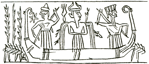
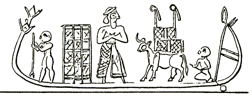
In ancient texts and pictures, the craft of the Nefilim were
initially termed "celestial boats." The landing of such "maritime"
astronauts, one can imagine, might have been described in ancient
epic tales as the appearance of some kind of submarine from the
heavens in the sea, from which "fish-men" emerged and came ashore.
The texts do, in fact, mention that some of the AB.GAL who navigated
the spaceships were dressed as fish. One text dealing with Ishtar's
divine journeys quotes her as seeking to reach the "Great gallu"
(chief navigator) who had gone away "in a sunken boat." Berossus
transmitted legends regarding Oannes, the "Being Endowed with
Reason," a god who made his appearance from "the Erythrean sea which
bordered on Babylonia," in the first year of the descent of Kingship
from Heaven.
Berossus reported that though Oannes looked like a
fish, he had a human head under the fish's head, and had feet like a
man under the fish's tail.
"His voice too and language were
articulate and human."
The three, Greek historians through whom we know what Berossus
wrote, reported that such divine fish-men appeared periodically,
coming ashore from the "Erythrean sea" - the body of water we now
call the Arabian Sea (the western part of the Indian Ocean).
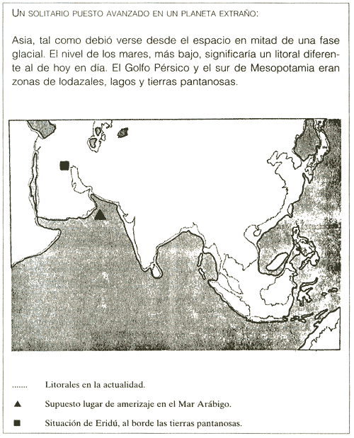
Why would the Nefilim splash down in the Indian Ocean, hundreds of
miles from their selected site in Mesopotamia, instead of in the
Persian Gulf, which is so much closer?
The ancient reports
indirectly confirm our conclusion that the first landings occurred
during the second glacial period, when today's Persian Gulf was not
a sea but a stretch of marshlands and shallow lakes, in which a
splashdown was impossible.
Coming down in the Arabian Sea, the first intelligent beings on
Earth then made their way toward Mesopotamia. The marshlands
extended deeper inland than today's coastline. There, at the edge of
the marshes, they established their very first settlement on our
planet.
They named it E.RI.DU ("house in faraway built"). What an
appropriate name!
To this very day, the Persian term ordu means "encampment." It is a
word whose meaning has taken root in all languages: The settled
Earth is called Erde in German, Erda in Old High German, Jordh in
Icelandic, Jord in Danish, Airtha in Gothic, Erthe in Middle
English; and, going back geographically and in time, "Earth" was
Araiha or Ereds in Aramaic, Erd or Ertz in Kurdish, and Eretz in
Hebrew.
At Eridu, in southern Mesopotamia, the Nefilim established Earth-
Station I, a lonely outpost on a half-frozen planet.
Sumerian texts, confirmed by later Akkadian translations, list the
original settlements or "cities" of the Nefilim in the order in
which they were established.
We are even told which god was put in
charge of each of these settlements. A Sumerian text, believed to
have been the original of the Akkadian "Deluge Tablets," relates the
following regarding five of the first seven cities:
After kingship had been lowered from heaven,
after the exalted
crown,
the throne of kingship had been lowered from heaven,
he ...
perfected the procedures,
the divine ordinances...
Founded five
cities in pure places,
called their names,
laid them out as centers.
The first of these cities, ERIDU,
he gave to Nudimmud, the leader,
The second, BAD-TIBIRA,
he gave to Nugig.
The third, LARAK,
he gave to Pabilsag.
The fourth, SIPPAR,
he gave to the hero Utu.
The fifth, SHURUPPAK,
he gave to Sud.
The name of the god who lowered Kingship from Heaven, planned the
establishment of Eridu and four other^ cities, and appointed their
governors or commanders, is unfortunately obliterated. All the texts
agree, however, that the god who waded ashore to the edge of the
marshlands and said "Here we settle" was Enki, nicknamed "Nudimmud"
("he who made things") in the text.
This god's two names - EN.KI ('lord of firm ground") and E.A ("whose
house is water") - were most appropriate. Eridu, which remained
Enki's seat of power and center of worship throughout Mesopotamian
history, was built on ground artificially raised above the waters of
the marshlands.
The evidence is contained in a text named (by S. N.
Kramer) the "Myth of Enki and Eridu":
The lord of the watery-deep, the king Enki.
built his house.
In Eridu he built the House of the Water Bank.
The king Enki... has built a house
Eridu, like a mountain,
he raised up from the earth;
in a good place he had built it.
These and other, mostly fragmentary texts suggest that one of the
first concerns of these "colonists" on Earth had to do with the
shallow lakes or watery marshes.
"He brought...; established the
cleaning of the small rivers."
The effort to dredge the beds of
streams and tributaries to allow a better flow of the waters was
intended to drain the marshes, obtain cleaner, potable water, and
implement controlled irrigation. The Sumerian narrative also
indicates some landfilling or the raising of dikes to protect the
first houses from the omnipresent waters.
A text named by scholars the "myth" of "Enki and the Land's Order"
is one of the longest and best preserved of Sumerian narrative poems
so far uncovered. Its text consists of some 470 lines, of which 375
are perfectly legible. Its beginning (some 50 lines) is,
unfortunately, broken. The verses that follow are devoted to an
exaltation of Enki and to the establishment of his relationship with
the chief deity Anu (his father), Ninti (his sister), and Enlil (his
brother).
Following these introductions, Enki himself "picks up the
microphone."
As fantastic as it may sound, the fact is that the text
amounts to a first-person report by Enki of his landing on Earth.
"When I approached Earth,
there was much flooding.
When I approached its green meadows,
heaps and mounds were piled up
at my command.
I built my house in a pure place...
My house -
Its shade stretches over the Snake Marsh....
The carp fish wave their tails in it
among the small gizi reeds."
The poem then goes on to describe and record, in the third person,
the achievements of Enki.
Here are some selected verses:
He marked the marshland,
placed in it carp and... - fish;
He marked the cane thicket,
placed in it... - reeds and green-reeds.
Enbilulu, the Inspector of Canals,
he placed in charge of the marshlands.
Him who set net so no fish escapes,
whose trap no ... escapes, .
whose snare no bird escapes,
...the son of... a god who loves fish
Enki placed in charge of fish and birds.
Enkimdu, the one of the ditch and dike, Enki placed in charge of
ditch and dike.
Him whose... mold directs, Kulla, the brick-maker of the Land,
Enki placed in charge of mold and brick.
The poem lists other achievements of Enki, including the
purification of the waters of the Tigris River and the joining (by
canal) of the Tigris and Euphrates.
His house by the watery bank
adjoined a wharf at which reed rafts and boats could anchor, and
from which they could sail off. Appropriately, the house was named E.ABZU ("house of the Deep"). Enki's sacred precinct in Eridu was
known by this name for millennia thereafter.
No doubt Enki and his landing party explored the lands around Eridu,
but he appears to have preferred traveling by water. The marshland,
he said in one of the texts, "is my favorite spot; it stretches out
its arms to me." In other texts Enki described sailing in the
marshlands in his boat, named MA.GUR (literally, "boat to turn about
in"), namely, a touring boat. He tells how his crewmen "drew on the
oars in unison," how they used to "sing sweet songs, causing the
river to rejoice."
At such times, he confided, "sacred songs and
spells filled my Watery Deep."
Even such a minor detail as the name
of the captain of Enki's boat is recorded.
The Sumerian king lists indicate that Enki and his first group of
Nefilim remained alone on Earth for quite a while: Eight shar's
(28,800 years) passed before the second commander or "settlement
chief" was named.
Interesting light is shed on the subject as we examine the
astronomical evidence. Scholars have been puzzled by the apparent
Sumerian "confusion" regarding which one of the twelve zodiacal
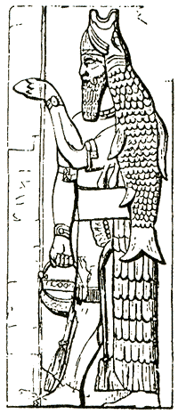
houses was associated with Enki. The sign of the fish-goat, which
stood for the constellation Capricorn, was apparently associated
with Enki (and, indeed, may explain the epithet of the founder of
Eridu, A.LU.LIM, which could mean "sheep of the glittering waters").
Yet Ea/Enki was frequently depicted as holding vases of flowing
waters - the original Water Bearer, or Aquarius; and he was
certainly the God of Fishes, and thus associated with Pisces.
Astronomers are hard put to clarify how the ancient stargazers
actually saw in a group of stars the outlines of, say, fishes or a
water bearer. The answer that comes to mind is that the signs of the
zodiac were not named after the shape of the star group but after
the epithet or main activity of a god primarily associated with the
time when the vernal equinox was in that particular zodiacal house.
If Enki landed on Earth - as we believe - at the start of an Age of
Pisces, witnessed a processional shift to Aquarius, and stayed
through a Great Year (25,920 years) until an Age of Capricorn began,
then he was indeed in sole command on Earth the purported 28,800
years.
The reported passage of time also confirms our earlier conclusion
that the Nefilim arrived on Earth in the midst of an ice age. The
hard work of raising dikes and digging canals commenced when
climatic conditions were still harsh. But within a few shar's of
their landing, the glacial period was giving way to a warmer and
rainier climate (circa 430,000 years ago).
It was then that the Nefilim decided to move farther inland and expand their settlements.
Befittingly, the Anunnaki (rank-and-file Nefilim) named the second
commander of Eridu "A.LAL.GAR" ("he who is raintime brought rest").
But while Enki was enduring the hardships of a pioneer on Earth, Ann
and his other son Enlil were watching the developments from the
Twelfth Planet. The Mesopotamian texts make it clear that the one
who was really in charge of the Earth mission was Enlil; and as soon
as the decision was made to proceed with the mission, Enlil himself
descended to Earth. For him a special settlement or base named Larsa
was built by EN.KI.DU.NU ("Enki, digs deep").
When Enlil took
personal charge of the place, he was nicknamed ALIM ("ram"),
coinciding with the "age" of the zodiacal constellation Aries.
The establishment of Larsa launched a new phase in the settlement of
Earth by the Nefilim. It marked the decision to proceed with the
tasks for which they had come to Earth, which required the shipping
to Earth of more "manpower," tools, and equipment, and the return of
valuable cargoes to the Twelfth Planet.
Splashdowns at sea were no longer adequate for such heavier loads.
The climatic changes made the interior more accessible; it was time
to shift the landing site to the center of Mesopotamia. At that
juncture, Enlil came to Earth and proceeded from Larsa to establish
a "Mission Control Center" - a sophisticated command post from which
the Nefilim on Earth could coordinate space journeys to and from
their home planet, guide in landing shuttle-craft, and perfect their
takeoffs and dockings with the spaceship orbiting Earth.
The site Enlil selected for this purpose, known for millennia as
Nippur, was named by him NIBRU.KI ("Earth's crossing"). (We recall
that the celestial site of the Twelfth Planet's closest pass to
Earth was called the "Celestial Place of the Crossing.") There Enlil
established
the DUR.AN.KI, the "bond Heaven-Earth."
The task was understandably complex and time-consuming. Enlil stayed
in Larsa for 6 shar's (21,600 years) while Nippur was under
construction. The Nippurian undertaking was also lengthy, as
evidenced by the zodiacal nicknames of Enlil. Having paralleled the
Ram (Aries) while
I in Larsa, he was subsequently associated with the Bull (Taurus).
Nippur was established in the "age" of Taurus.
A devotional poem composed as a "Hymn to Enlil, the All-Beneficent"
and glorifying Enlil, his consort Ninlil, his city Nippur, and its
"lofty house," the E.KUR, tells us much about Nippur.
For one thing, Enlil had at his disposal there some highly sophisticated
instruments: a "lifted 'eye' which scans the land," and a "lifted
beam which searches the heart of all the land." Nippur, the poem
tells us, was protected by awesome weapons: "Its sight is awesome
fear, dread"; from "its outside, no mighty god can approach."
Its
"arm" was a "vast net," and in its midst there crouched a
"fast-stepping bird," a "bird" whose "hand" the wicked and the evil
could not escape. Was the place protected by some death ray, by an
electronic power field? Was there in its center a helicopter pad, a
"bird" so swift no one could outrun its reach?
In the center of Nippur, atop an artificially raised platform, stood
Enlil's headquarters, the KI.UR ("place of Earth's root") - the
place where the "bond between Heaven and Earth" rose. This was the
communications center of Mission Control, the place from which the
Anunnaki on Earth communicated with their comrades, the IGI.GI
("they who turn and see") in the orbiting spacecraft.
At this center, the ancient text goes on to say, stood a "heavenward
tall pillar reaching to the sky." This extremely tall "pillar,"
firmly planted on the ground "as a platform that cannot be
overturned," was used by Enlil to "pronounce his word"
heavenward/This is a simple description of a broadcasting tower.
Once the "word of Enlil" - his command - "approached heaven,
abundance would pour down on Earth." What a simple way to describe
the flow of materials, special foods, medicines, and tools brought
down by the shuttlecraft, once the "word" from Nippur was given!
This Control Center on a raised platform, Enlil's "lofty house,"
contained a mysterious chamber, named the DIR.GA:
As mysterious as the distant Waters,
as the Heavenly Zenith.
Among its ... emblems,
the emblems of the stars.
The ME it carries to perfection.
Its words are for utterance....
Its words are gracious oracles.
What was this dirga?
Breaks in the ancient tablet have robbed us of
more data; but the name speaks for itself, for it means "the dark, crownlike chamber," a place where star charts were kept, where
predictions were made, where the me (the astronaut's
communications)" were received and transmitted. The description
reminds us of Mission Control in Houston, Texas, monitoring the
astronauts on their Moon missions, amplifying their communications,
plotting their courses against the starry sky, giving them "gracious
oracles" of guidance.
We may recall here the tale of the god Zu, who made his way to
Enlil's sanctuary and snatched away the Tablet of Destinies,
whereupon,
"suspended was the issuance of commands... the hallowed
inner chamber lost its brilliance... stillness spread...
silence prevailed."
In the "Epic of Creation," the "destinies" of the planetary gods
were their orbits.
It is reasonable to assume that the Tablet of
Destinies, which was so vital to the functions of Enlil's "Mission
Control Center," also controlled the orbits and flight paths of the
spaceships that maintained the "bond" between Heaven and Earth. It
might have been the vital "black box" containing the computer
programs that guided the spaceships, without which the contact
between the Nefilim on Earth and their link to the Home Planet was
disrupted.
Most scholars take the name EN.LIL to mean "lord of the wind," which
fits the theory that the ancients "personilized" the elements of
nature and thus assigned one god to be in charge of winds and
storms.
Yet some scholars have already suggested that in this
instance the term LIL means not a stormy wind of nature but the
"wind" that comes out of the mouth - an utterance, a command, a
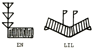
spoken communication. Once again, the archaic Sumerian pictographs
for the term EN - especially as applied to Enlil - and for the term
LIL, shed light on the subject.
For what we see is a structure with
a high tower of antennas rising from it, as well as a contraption
that looks very much like the giant radar nets erected nowadays for
capturing and emitting signals - the "vast net" described in the
texts.
In Bad-Tibira, established as an industrial center, Enlil installed
his son Nannar/Sin in command; the texts speak of him in the list of
cities as NU.GIG ("he of the night sky").
There, we believe, the
twins Inanna/Ishtar and Utu/Shamash were born - an event marked by
associating their father Nannar with the next zodiacal
constellation, Gemini (the Twins). As the god trained in rocketry,
Shamash was assigned the constellation GIR (meaning both "rocket"
and "the crab's claw," or Cancer), followed by Ishtar and the Lion
(Leo), upon whose back she was traditionally depicted.
The sister of Enlil and Enki, "the nurse" Ninhursag (SUD), was not
neglected: In her charge Enlil put Shurup-pak, the medical center of
the Nefilim - an event marked by naming her constellation "The Maid"
(Virgo).
While these centers were being established, the completion of Nippur
was followed by the construction of the spaceport of the Nefilim on
Earth.
The texts made clear that Nippur was the place where the
"words" - commands - were uttered: There, when "Enlil commanded:
'Towards heaven!'... that which shines forth rose like a sky
rocket."
But the action itself took place "where Shamash rises," and
that place - the "Cape Kennedy" of the Nefilim - was Sippar, the
city in the charge of the Chief of the Eagles, where multistage
rockets were raised within its special enclave, the "sacred
precinct."
As Shamash matured to take command of the Fiery Rockets, and in time
also to become the God of Justice, he was assigned the
constellations Scorpio and Libra (the Scales).
Completing the list of the first seven Cities of the Gods and the
correspondence with the twelve zodiac constellations was Larak,
where Enlil put his son Ninurta an command. The city lists call him
PA.BIL.SAG ("great protector"); it is the same name by which the
constellation Sagittarius was called.
It would be unrealistic to assume that the first seven Cities of the
Gods were established haphazardly. These "gods," who were capable of
space travel, located the first settlements in accordance with a
definite plan, serving a vital need: to be able to land on Earth and
to leave Earth for their own planet.
What was the master plan?
As we searched for an answer, we asked ourselves a question: What is
the origin of Earth's astronomical and astrological symbol, a circle
bisected by a right-angled cross - the symbol we use to signify
"target"?
The symbol goes back to the origins of astronomy and f astrology in
Sumer and is identical with the Egyptian -hieroglyphic sign for
"place":

Is this coincidence, or significant evidence? Did the Nefilim land
on Earth by superimposing on its image or map some kind of "target"?
The Nefilim were strangers to Earth. As they scanned its surface
from space, they must have paid special attention to the mountains
and mountain ranges. These could present hazards during landings and
takeoffs, but they could also serve as navigational landmarks.
If the Nefilim, as they hovered over the Indian Ocean, looked toward
the Land Between the Rivers, which they had selected for their
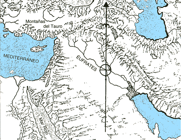
earliest colonizing efforts, one landmark stood out unchallenged:
Mount Ararat.
An extinct volcanic massif, Ararat dominates the Armenian plateau
where the present-day borders of Turkey, Iran, and Soviet Armenia
meet. It rises on the eastern and northern sides to some 3,000 feet
above sea level, and on the northwestern side to 5,000 feet. The
whole massif is some twenty-five miles in diameter, a towering dome
sticking out from the surface of Earth,
Other features make it stand out not only from the horizon but also
from high in the skies. First, it is located almost midway between
two lakes, Lake Van and Lake Se-Van. Second, two peaks rise from the
high massif: Little Ararat (12,900 feet) and Great Ararat (17,000
feet - well over 5 kilometers). No other mountains rival the
solitary heights of the two peaks, which are permanently
snow-covered. They are like two shining beacons between the two
lakes that, in daylight, act as giant reflectors.
We have reason to believe that the Nefilim selected their landing
site by coordinating a north - south meridian with an unmistakable
landmark and a convenient river location.
North of Mesopotamia, the
easily identifiable twin-peaked Ararat would have been the obvious
landmark. A meridian drawn through the center of the twin-peaked
Ararat bisected the Euphrates. That was the target - the site
selected for the spaceport.
Could one easily land and take off there?
The answer was Yes.
The selected side lay in a plain; the mountain
ranges surrounding Mesopotamia were a substantial distance away. The
highest ones (to the east, northeast, and north) would not interfere
with a space shuttle gliding in from the southeast.
Was the place accessible - could astronauts and materials be brought
there without too much difficulty?
Again, the answer was Yes. The site could be reached overland and,
via the Euphrates River, by waterborne craft.
And one more crucial question: Was there a nearby source of energy,
of fuel for light and power? The answer was an emphatic Yes.
The
bend in the Euphrates River where Sippar was to be established was
one of the richest known sources in antiquity of surface bitumens,
petroleum products that seeped up through natural wells and could be
collected from the surface without any deep digging or drilling.
We can imagine Enlil, surrounded by his lieutenants at the
spacecraft's command post, drawing the cross within a circle on the
map.
"What shall we call the place?" he may have asked.
"Why not 'Sippar'?" someone might have suggested.
In Near Eastern languages, the name means "bird." Sippar was the
place where the Eagles would come to nest.
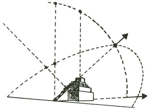
How would the space shuttles glide down to Sippar?
We can visualize one of the space navigators pointing out the best
route. On the left they had the Euphrates and the mountainous
plateau west of it; on the right, the Tigris and the Zagros range
east of it. If the craft were to approach Sippar at the easily set
angle of 45 degrees to the Ararat meridian, its path would take it
safely between these two hazardous areas.
Moreover, coming in to
land at such an angle, it would cross in the south over the rocky
tip of Arabia while at a high altitude, and start its glide over the
waters of the Persian Gulf. Coming and going, the craft would have
an unobstructed field of vision and of communication with Mission
Control at Nippur.
Enlil's lieutenant would then make a rough sketch - a triangle of
waters and mountains on each side, pointing like an arrow toward
Sippar.
An "X" would mark Nippur, in the center
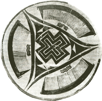
Incredible as it may seem, this sketch was not made by us; the
design was drawn on a ceramic object unearthed at Susa, in a stratum
dated to about 3200 B.C. It brings to mind the planisphere that
described the flight path and procedures, which was based on
45-degree segments.
The establishment of settlements on Earth by the Nefilim was not a
hit-or-miss effort. All the alternatives were studied, all the
resources evaluated, all the hazards taken into account; moreover,
the settlement plan itself was carefully mapped out so that each
site fit into the final pattern, whose purpose was to outline the
landing path to Sippar.
No one has previously attempted to see a master plan in the
scattered Sumerian settlements. But if we look at the first seven
cities ever established, we find that Bad-Tibira, Shuruppak, and
Nippur lay on a line running precisely at a 45-degree angle to the
Ararat meridian, and that line crossed the meridian exactly at
Sippar! The other two cities whose sites are known, Eridu and Larsa,
also Iay on another straight line that crossed the first line and
the^ Ararat meridian, also at Sippar.
Taking our cue from the ancient sketch, which made Nippur the center
of a circle, and drawing concentric circles from Nippur through the
various cities, we find that another ancient Sumerian town, Lagash,
was located exactly on one of these circles - on a line equidistant
from the 45-degree line, like the Eridu-Larsa-Sippar line. The
location of Lagash mirrors that of Larsa.
Though the site of LA.RA.AK ("seeing the bright halo") remains
unknown, the logical site for it would be at Point 5, since there
logically was a City of the Gods there, completing the string of
cities on the central flight path at intervals of six beru:
-
Bad-Tibira
-
Shuruppak
-
Nippur
-
Larak
-
Sippar
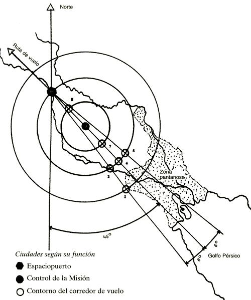
The two outside lines, flanking the central line running through
Nippur, lay 6 degrees on each side of it, acting as southwest and
northeast outlines of the central flight path.
Appropriately, the
name LA.AR.SA meant "seeing the red light"; and LA.AG.ASH meant
"seeing the halo at six." The cities along each line were indeed six
beru (approximately sixty kilometers, or thirty-seven miles) from
each other.
This, we believe, was the master plan of the Nefilim. Having
selected the best location for their spaceport (Sippar), they laid
out the other settlements in a pattern outlining the vital flight
path to it. In the center they placed Nippur, where the "bond
Heaven-Earth" was located.
Neither the original Cities of the Gods nor their remains can ever
be seen by man again - they were all destroyed by the Deluge that
later swept over Earth. But we can learn much about them because it
was the sacred duty of Mesopotamian kings continuously to rebuild
the sacred precincts in exactly the same spot and according to the
original plans.
The rebuilders stressed their scrupulous adherence
to the original plans in their dedication inscriptions, as this one
(uncovered by Layard) stated:
The everlasting ground plan,
that which for the future
the construction determined
[I have followed].
It is the one which bears
the drawings from the Olden Times
and the writing of the Upper Heaven.
If Lagash, as we suggest, was one of the cities that served as a
landing beacon, then much of the information provided by Gudea in
the third millennium B.C. makes sense.
He wrote that when Ninurta
instructed him to rebuild the sacred precinct, an accompanying god
gave him the architectural plans (drawn on a stone tablet), and a
goddess (who had "travelled between Heaven and Earth" in her
"chamber") showed him a celestial map and instructed him on the
astronomical alignments of the structure.
In addition to the "divine black bird," the god's "terrible eye"
("the great beam that subdues the world to its power") and the
"world controller" (whose sound could "reverberate all over") were
installed in the sacred precinct. Finally, when the structure was
complete, the "emblem of Utu" was raised upon it, facing "toward the
rising place of Utu" - toward the spaceport at Sippar.
All these
beaming objects were important to the spaceport's operation, for Utu
himself "came forth joyfully" to inspect the installations when
completed.
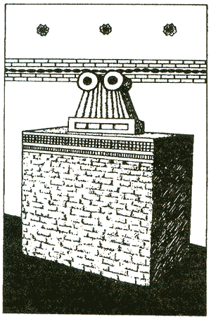
Early Sumerian depictions frequently show massive structures, built
in earliest times of reeds and wood, standing in fields among
grazing cattle. The current assumption that these were stables for
cattle is contradicted by the pillars that are invariably shown
protruding from the roofs of such structures.
The pillars' purpose, as one can see, was to support one or more
pairs of "rings," whose function is unstated. But although these
structures were erected in the fields, one must question whether
they were built to shelter cattle. The Sumerian pictographs depict
the word DUR, or TUR (meaning "abode," "gathering place"), by
drawings that undoubtedly represent the same structures shown on the
cylinder seals; but they make clear that the main feature of the
structure was not the "huts" but the antenna tower.
Similar pillars
with "rings" were posted at temple entrances, within the sacred
precincts of the gods, and not only out in the countryside.
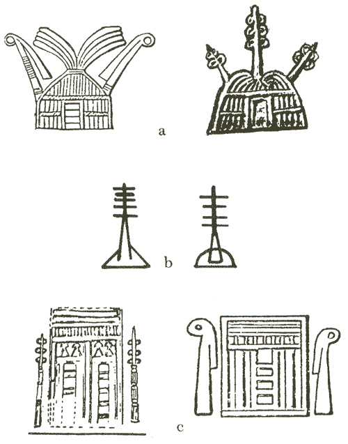
Were these objects antennas attached to broadcasting equipment?
Were
the pairs of rings radar emitters, placed in the fields to guide the
incoming shuttlecraft? Were the eyelike pillars scanning devices,
the "all-seeing eyes" of the gods of which many texts have spoken?
We know that the equipment to which these various devices were
connected was portable, for some Sumerian seals depict boxlike
"divine objects" being transported by boat or mounted on pack
animals, which carried the objects farther inland once the boats had
docked.
These "black boxes," when we see what they looked like, bring to
mind the Ark of the Covenant built by Moses under God's
instructions.
The chest was to be made of wood, overlaid with gold
both inside and outside - two electricity-conducting surfaces were
insulated by the wood between them. A kapporeth, also made of gold,
was to be placed above the chest and held up by two cherubim cast of
solid gold. The nature of the kapporeth (meaning, scholars
speculate, "covering") is not clear; but this verse from Exodus
suggests its purpose: "And I will address thee from above the
Kapporeth, from between the two Cherubim."
The implication that the Ark of the Covenant was principally a
communications box, electrically operated, is enhanced by the
instructions concerning its portability. It was to be carried by
means of wooden staffs passed through four golden rings. No one was
to touch the chest proper; and when one Israelite did touch it, he
was killed instantly - as if by a charge of high-voltage
electricity.
Such apparently supernatural equipment - which made it possible to
communicate with a deity though the deity was physically somewhere
else - became objects of veneration, "sacred cult symbols." Temples
at Lagash, Ur, Mari, and other ancient sites included among their
devotional objects "eye idols." The most outstanding example was
found at an "eye temple" at Tell Brak, in northwestern Mesopotamia.
This fourth-millennium temple was so named not only because hundreds
of "eye" symbols were un-earthed there but mainly because the
temple's inner sanctum had only one altar, on which a huge stone
"double-eye" symbol was displayed.
In all probability, it was a simulation of the actual divine object
- Ninurta's "terrible eye," or the one at Enlil's Mission Control
Center at Nippur, about which the ancient scribe reported:
"His
raised Eye scans the land.... His raised Beam searches the land."
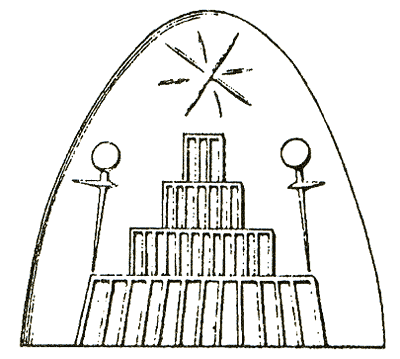
The flat plain of Mesopotamia necessitated, it seems, the artificial
raising of platforms on which the space-related equipment was to be
placed.
Texts and pictorial depictions leave no doubt that the
structures ranged from the earliest field huts to the later staged
platforms, reached by staircases and sloped ramps that led from a
broad lower stage to a narrower upper one, and so on. At the top of
the ziggurat an actual residence for the god was built, surrounded
by a flat, walled courtyard to house his "bird" and "weapons."
A
ziggurat depicted on a cylinder seal not only shows the customary
stage-upon-stage construction, it also has two "ring antennas" whose
height appears to have equaled three stages.
Marduk claimed that the ziggurat and temple compound at Babylon (the
E.SAG.IL) had been built under his own instructions also in
accordance with the "writing of Upper Heaven."
A tablet (known as
the Smith Tablet, after its decipherer), analyzed by Andre Parrot
(Ziggurats et Tour de Babel) established that the seven-stage
ziggurat was a perfect square, with the first stage or base having
sides of 15 gar each. Each successive stage was smaller in area and
in height, except the last stage (the god's residence), which was of
a greater height. The total height, however, was again equal to 15
gar, so that the complete structure was not only a perfect square
but a perfect cube as well.
The gar employed in these measurements was equivalent to 12 short
cubits - approximately 6 meters, or 20 feet. Two scholars, H. G.
Wood and L. C. Stecchini, have shown that the Sumerian sexagesimal
base, the number 60, determined all the primary measurements of
Mesopotamian ziggurats.
Thus each side measured 3 by 60 cubits at
its base, and the total was 60 gar.
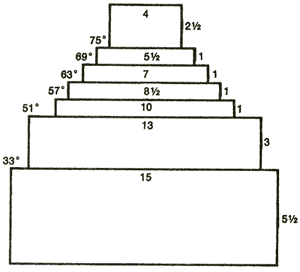
What factor determined the height of each stage?
Stecchini
discovered that if he multiplied the height of the first stage (5.5
gar) by double cubits, the result was 33, or the approximate
latitude of Babylon (32.5 degrees North). Similarly calculated, the
second stage raised the angle of observation to 51 degrees, and each
of the succeeding four stages raised it by another 6 degrees.
The
seventh stage thus stood atop a platform raised to 75 degrees above
the horizon at Babylon's geographic latitude. This final stage added
15 degrees - letting the observer look straight up, at a 90-degree
angle. Stecchini concluded that each stage acted like a stage of an
astronomical observatory, with a predetermined elevation relative to
the arc of the sky.
There may, of course, have been more "hidden" considerations in
these measurements. While the elevation of 33 degrees was not too
accurate for Babylon, it was precise for Sippar. Was there a
relationship between the 6-degree elevation at each of four stages
and the 6-beru distances between the Cities of the Gods? Were the
seven stages somehow related to the location of the first seven
settlements, or to Earth's position as the seventh planet?
G. Martiny (Astronomisches zur babylonischen Turm) showed how these
features of the ziggurat suited it for celestial observations, and
that the topmost stage of the Esagila was oriented toward the planet
Shupa (which we have identified as Pluto) and the constellation
Aries.
But were the ziggurats raised solely to observe the stars and
planets, or were they also meant to serve the spacecraft of the
Nefilim?
All the ziggurats were oriented so that their corners
pointed exactly north, south, east, and west. As a result, their
sides ran precisely at 45-degree angles to the four cardinal
directions. This meant that a space shuttle coming in for a landing
could follow certain sides of the ziggurat exactly along the flight
path - and reach Sippar without difficulty!
The Akkadian/Babylonian name for these structures, zukiratu,
connoted "tube of divine spirit." The Sumerians called the ziggurats
ESH; the term denoted "supreme" or "most high" - as indeed these
structures were. It could also denote a numerical entity relating to
the "measuring" aspect of the ziggurats. And it also meant "a heat
source" ("fire" in Akkadian and Hebrew).
Even scholars who have approached the subject without our "space"
interpretation could not escape the conclusion that the ziggurats
had some purpose other than to make the god's abode a "high-rise"
building.
Samuel N. Kramer summed up the scholastic consensus:
"The
ziggurat, the stagetower, which became the hallmark of Mesopotamian
temple architecture... was intended to serve as a connecting
link, both real and symbolic, between the gods in heaven and the
mortals on earth."
We have shown, however, that the true function of these structures
was to connect the gods in Heaven with the gods - not the mortals -
on Earth.
Return to Contents
|